Content warning Portions of descriptions and imagery on this page contain inaccurate views, derogatory language, and offensive imagery. They are included here as they were originally created in order to compile a complete reproduction. They do not reflect the attitudes of this site’s creator.
Introduction
Geography is the science which treats of the surface of the earth.
Three branches of geography are usually distinguished, according to the different points from which it is viewed, viz., Mathematical, Physical, and Civil. Mathematical (sometimes called Astronomical) Geography treats of the earth as a part of the solar system, investigating its size, shape, orbital and rotatory motions, and its relation to other heavenly bodies; it may therefore be considered as part of Astronomy. Physical Geography treats of the natural features of the earth, of the dry land and sea, of the fresh waters, and of the atmosphere encompassing it, the part having reference to the latter (Meteorology) being often thrown into connexion with Natural Philosophy or Physics, as we have done (see vol. i. p. 184). Finally, Political Geography considers the earth as the habitation of mankind, and accordingly treats of the division of its surface into states and countries; of the different towns, villages, and works of art; of the various races and tribes, with their dialects, religion, and government, and manner of life in general. Mathematical and Physical Geography, taken together, may be called General Geography, as distinguished from Political or Special Geography. To the latter belongs also, in fact. Historical Geography, which has reference to the condition of geographical science at different epochs, as well as to the political divisions and arrangements of the earth at different times.
![]() General Geography
General Geography
 General Geography
The most important facts in respect to Mathematical Geography having already been presented under the head of Astronomy, we shall here be very brief in reference to this subject. That the earth is round, differing but little in shape from a sphere, has already been mentioned; also, that it turns once in twenty-four hours on an axis, the extremities of which are called respectively the North and South Poles. That great circle of the earth’s surface to which her axis stands perpendicular, is called the Equator; every point of this is equally distant from either pole, and the whole circle divides the earth into two hemispheres, a Northern and a Southern. All circles parallel to the equator are parallel circles, or parallels of latitude. Great circles passing through both poles are called Meridians. The geographical latitude of a place is its angular distance from the equator, measured along a meridian; it will be north or south as the place is north or south of the equator. The geographical longitude of a place is that arc of the equator intercepted between two meridians, one passing through the place and the other through the arbitrary point to which the longitude is referred. This latter meridian is called the first or fixed meridian, and differs in different countries. The French take as their first meridian the one passing through the observatory at Paris; the Germans make use of the meridian of Ferro, 20° west of that at Paris, and passing near the island of Ferro. The English make all references to the meridian of Greenwich, 17° 46′ east of that of Ferro, as do the Americans also. In this country, however, an effort has recently been made to have a meridian of our own, passing through the city of New Orleans, as most convenient on account of its being as nearly as possible 90° west of Greenwich. Our maps are drawn with reference to the meridian of Ferro, but for greater convenience we shall use the meridian of Greenwich in the body of the work. Longitude may be reckoned either west and east to the amount of 180° each, or entirely west to 360°. The two circles of latitude at distances of 23\(\frac{1}{2}\)° on each side of the equator, arc called the Tropics (the northern is the Tropic of Cancer, the southern the Tropic of Capricorn): the Polar or Arctic circles are those circles of latitude 23\(\frac{1}{2}\)° from each pole, the northern parallel being the Arctic, the southern the Anatarctie circle. These four circles divide the earth into five zones: one torrid, two temperate, and two frigid. The torrid scone is bounded by the two tropics, and embraces all that part of the earth where the rays of the sun fail vertically once or twice a year. The north frigid zone lies within the Arctic circle, the south frigid zone within the Antaretic: both together include that portion of the earth where the sun, (luring the summer, does not fall below the horizon for from twenty-four hours to six months and during winter does not pass above the horizon for the same limits of time. Each of the temperate zones lies between the tropic and polar circles of its hemisphere. The two temperate zones together include more than half \(\frac{52}{100}\) of the entire surface of the earth, the torrid embracing \(\frac{40}{100}\), and the two frigid only \(\frac{8}{100}\).
The equator, like any other circle, is divided into 360°. the sixteenth part of a degree, or one minute, being called a geographical mile. The entire circumference of the earth at the equator will therefore be 21,600 geographical miles, the diameter being 6875\(\frac{1}{2}\). Were the earth a perfect sphere, then, her surface would amount to about 148,512,000 square miles, and her volume to 170,176 millions of cubic miles. Measurements, however, carried on at various times, and in various places, within the last one hundred years, have shown that degrees of the meridian, are not of the same length at all latitudes, but that they increase slightly from the equator towards the poles; it has hence been concluded that the earth in all strictness is not a sphere, but an elliptical spheroid, flattened or depressed at the pole, or in other words, is such a body as would be produced by the rotation of an ellipse about its minor axis. Nevertheless, the difference between the greatest and least diameters of the earth, or the oblateness, amounts only to about \(\frac{1}{305}\) of the former (the equatorial), or to about twenty-six statute miles. The following table expresses the dimensions of the earth, as given in English statute miles:
- Radius at the equator, 3962.6.
- Radius at the pole, 3949.6.
- Mean radius, or at 45° latitude, 3956.1.
- Mean length of a degree, 69.05.
- The fourth part of a meridian, 6214.2.
The length of an English geographical mile is equal to about 2025 yards. As the statute mile is 1760 yards, the ratio between the two is as 1:1.15, The Germans count fifteen geographical miles to the degree. Consequently one German geographical mile is equal to four English ditto; and one German geographical mile equals 4.6 English statute or ordinary miles. The squares of these values expressing square miles will then be to each other as 1 to 21.16. Unless otherwise stated, future measurements will be expressed in English geographical miles. The reduction to statute miles can, however, be readily made by multiplying by 1.15. We add a comparison of some French and English measures for the sake of convenience in reduction:
- French foot = 1.065.765 English feet.
- French metre = 39.370.091 English yards.
- French toise= 6.394.592 English feet.
Coming now to the subject of Physical Geography, we shall present a condensed description of the surface of the earth, introducing as many of such accessories to Physical Geography, as the distribution of plants and animals, aerial and oceanic currents, (fee, as may be necessary for the proper elucidation of the plates.
The entire surface of the earth includes about 148,160,000 geographical square miles, of which about one fourth belongs to the land, and the remainder to the sea. The world of waters which thus covers the greater part of the earth, may be divided into five principal bodies or oceans: the Arctic, the Antarctic, the Atlantic, the Pacific, and the Indian.
The Arctic Ocean extends from the arctic circle towards the north pole: the Antarctic, from the antarctic circle to the south pole. The two are for the most part continually frozen, and consequently inaccessible.
The Pacific Ocean is bounded to the west by Asia and New Holland, to the east by the Americas; to the south it is continuous with the Antarctic Ocean, communicating to the north with the Arctic Ocean, through Behring’s Straits. Its area amounts to about 44,800,000 square miles, or nearly one third of the entire surface of the earth. The southern part of the Pacific Ocean is sometimes called the South Sea.
The Atlantic Ocean is bounded to the west by the Americas, to the east by Europe and Africa; it is continuous to the north with the Arctic Ocean, to the south-west with the Pacific, and to the south-east with the Indian.
The Indian Ocean lies between the Atlantic and Pacific Oceans, bordering to the north on Asia, to the east on New Holland, to the south on the Antarctic Ocean, and to the west on Africa.
The dry land belonging to the earth is divided into five parts or continents: Europe, Asia, Africa, the Americas, and New Holland. The largest of these is Asia, with about 14,128,000 square miles; then comes North America with 5,472,000; South America with 5,136,000; Africa with 8,720,000; Europe with 2,688,000; and lastly, New Holland, or Australia, with 2,208,000 square miles.
Europe
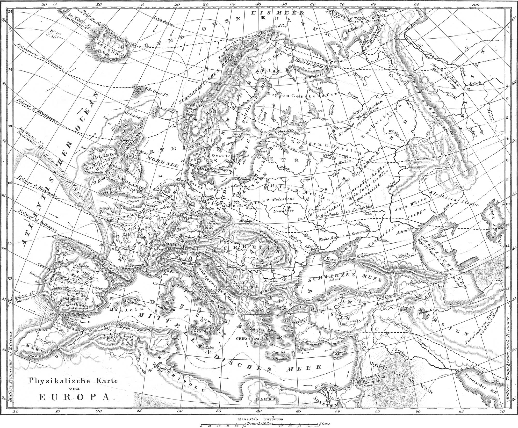
Europe extends from 36° to 71° north latitude, and from 9° west to 60° 20′ east longitude, reckoning from Greenwich. It is bounded on the north by the Arctic Ocean, on the South and west by the Atlantic, and to the east by Asia. It eastern line of division from Asia has been variously assigned, although the Ural Mountains are now generally taken as the boundary. Its area amounts, as already remarked, to about 2,688,000 geographical square miles; its coast line to 17,200 linear geographical miles.
The Arctic Ocean, or Icy Sea, presents one gulf, the White Sea. Of the many indentations of the Atlantic Ocean may be mentioned: a, In the west of Europe, the Scandinavian Sea, west of Norway, extending to the Arctic Ocean; the English Channel between England and France; St. George’s Channel, or the Irish Sea, between England and Ireland; the North Sea, united to the ocean to the south by the Straits of Dover; the Skagerrack and the Cattegat, connecting the North Sea with the Baltic; the Baltic or East Sea, with the Gulfs of Bothnia and Finland, with Riga Bay and the Bay of Biscay to the west of France and north of Spain, b, In the south of Europe we have the Mediterranean Sea connected with the Atlantic by the Straits of Gibraltar, and having numerous minor gulfs and seas. The principal of these are the Gulf of Lyons on the south of France; the Tyrrhenian or Tuscan Sea, between Corsica, Sardinia, Sicily, and Italy; the Adriatic Sea to the east of Italy; the Ionian Sea betwen lower Italy and Greece; the Egaean Sea, or the Archipelago, between Greece and Asia Minor; the Sea of Marmora (Propontis), connected with the Egaean Sea through the Dardanelles (the Hellespont), and with the Black Sea through the Straits of Constantinople (the Bosphorus); finally the Black Sea with its gulf, the Sea of Azof.
The arrows placed in different parts of the seas represented on pl. 1, indicate the direction of the oceanic currents. Two kinds of currents may be distinguished: those produced by the action of the wind, and those entirely independent of this case. The latter are the most important, constituting true streams of from fifty to two hundred miles in width. One of the principal of these is that which, striking from the north-western shores of Africa, crosses towards America, passing round in the Gulf of Mexico, and thence continued to the north as the Gulf-stream. On reaching Newfoundland it is deflected eastwards, and passing south by the Azores, joins the equatorial current again, having made a circuit of 3800 miles, and embracing a vast space nearly stagnant in the centre, and known as the Sargasso Sea. An important branch current leaves the Gulf-stream near Newfoundland, and sets towards Britain and Norway. A current indicated on pl. 1 as “Rennel’s Strömung,” passes from the north-western corner of Spain, eastwards along the coast to Bayonne, then north along the coast of France, and across to the Irish coast at Cape Clear, then turning to the south-west; it thus describes an entire circle. A constant current passes from the Baltic through the Sound and the Cattegat into the North Sea; there is also a strong current from the Dardanelles into the Mediterranean. A double current passes by Gibraltar, an upper from the Atlantic into the Mediterranean, extending to the coast of Syria, and then turning back, and a second current towards the west, at a certain depth below the surface.

The largest Mountains of Europe are the Pyrenees, the Alps, and the Carpathians, to which may be added the Apennines, the Scandinavian Mountains, and others.
- The Pyrenees. These separate France from Spain, and are about 270 statute miles long, by a maximum breadth of sixty miles. The highest point is the Malahite, or Maladetta, 11,170 feet; the middle comb is about 7990 feet in mean altitude. The central Pyrenees contain the loftiest peaks, the eastern and western (the latter especially) being of less elevation. Other important mountains of the Spanish peninsula are the Sierra Nevada, the water-shed between the waters of the Atlantic and of the Mediterranean; the Sierra Morena on the southern edge; the Gruadarama; the Sierra de Toledo; the Sierra de Estrella in Portusral, &c.
- The Alps in Switzerland, South France, and Germany, and northern Italy (the principal mountain chain in Europe), are divided up into numerous ranges, and may be considered under the following heads: the French-Italian Alps (with the Maritime, Cottian, and Grey Alps), the Bernese, Valois, and Central Swiss Alps (with the Pennine, Lepontine, and Rhetian Alps), and the Austrian Alps in its more extended sense including the Norian, Carnian, Julian, and Dinarian Alps. The highest peaks are Mont Blanc, 15,739 feet; Monte Rosa, 15,210; Mont Cervin, 14,836; Finsteraarhorn, 14,026; Jungfrau, 13,672; Mont Iseran, 13,272; Ortier Spitz, 12,851; Mont Terglou, 9386.
- The Carpathians in Hungary, Galicia, and Siebenbürgen, divide into three principal members: the Highland of Siebenbürgen, the Carpathian Wald, and the Hungarian Carpathians. The highest peaks are Ruska Boyana, 9,912; Budosch, 9,593; Mount Tatra, 8,524.
- The Apennines in Middle and Lower Italy. Mount Etna in Sicily may be considered as the highest point (10,874 feet); on the mainland in the peninsula of Italy, the highest point is the Gran Sasso d’ltalia, or Monte Corno, in the Abruzzi (9529 feet).
- The Hæmus or Balkan in Turkey, with its southern spurs, Pangaeus, Rhodope, the Strandsje, and the Tekiri.
- The curve of mountains from the Cevennes to the Carpathians in Middle Europe, consisting of: a, the Cevennes in France, Mont d’Or (6200 feet) the highest point; b, the Jura, divided into the Swiss, the French, and the Suabian; c, the Middle Rhenish Mountains, divided into the Vosges or the Wasgau Mountains, with the Hardtgebirge and the Donnersberg on the left bank of the Rhine, the Schwarzwald (Feldberg 4675 feet high), the Odenwald, and the Spessart, on the right bank of the Rhine; d, the mountains in the north Germany and Belgium region, including the Ardennes, the Argonnerwald, the Eifel, the Hohewald and Hundsrück, the Siebengebirge, the Westerwald, Mount Taunus, the Rothhaargebirge, the Teuto burgerwald, and the Hartz; e, the Hessian Mountains (with the Rhoen, 3484 feet); the Meisner, the Yogelsgebirge, and the Habichtswald: f, the Bohemian Mountains, divided into the Fichtelgebirge, the Thuringerwald, the Frankenwald. the Erzgebirge, with the Mittelgebirge and the Saxonian Switzerland, the Lusatian Mountains, the Riesengebirge, the Sudetes, the mountains constituting the boundary between Bohemia and Moravia, and the Boehmerwald.
- The mountains of Great Britain attaining a height of 3557 feet in Snowdon (Wales), and 4380 in Ben Nevis (Scotland). The highest mountains in England are Cross Fell in Cumberland (3383), Helvyllen (3313), and Skiddaw (3083). The highest in Ireland is Curran Tual in the County Kerry (3412). Other prominent members of the mountain group of Great Britain, are the Cheviot Hills, the Pentland Hills, Lead Hills, the Peak Mountain, the Grampians, &c.
- The Scandinavian Movntains extend from the southern point of Norway over a length of nearly one thousand miles to the North Cape. The highest points are the Skagestoltind, 8101 feet high, and Sneehattan 8120.
The principal of the numerous Promontories and Capes of Europe are: 1, the North Cape, the most northern point of Europe, and situated on an island; 2, Cape Lindesnas, the southern point of Norway; 3, Arcona, the most northern point of Germany (on the Island of Rügen); 4, Skagen or Skagenshorn, the northern point of Jutland; 5, Duncansby Head, the northern point of Scotland; 6, Land’s-End, the southern point of England; 7, Cape de la Roca in Portugal, the most western point in Europe; 8, Cape St. Vincent, the south-western point of Europe; 9, Tarifa, not far from Gibraltar, the most southern point of Europe; 10, Cape delle Armi and Cape Spartivento, the southern point of the Italian mainland; 11, Cape Santa Maria di Leuca and Cape d’Otranto, the south-eastern points of Italy; 12, Cape Peloro, Cape Passaro, and Cape Boco, the three points of Sicily; 13, Cape Linguetta and Actium on the west coast of Greece; 14, the promontories of Gallo, Matapan, and St. Angelo, on the south side of the Morea; 15, Colonna (the ancient Sunium) on the south-eastern side of Greece.
The most important Valleys, Plains, and Lowlands of Europe, are as follows: 1, the valley of the Po, included between the chains of the Alps; 2, the valleys of the Rhone and Danube, united by the lowlands of the Aar and the Rhine. Portions of these are: a, from the Lake of Geneva to the Lake of Constance; b, from the Lake of Constance to Linz (the former is the Swiss lowlands, the latter the plain of Munich); c, from Linz to the Lake of Neusiedel; d, the valley of the Theiss or the great Hungarian plain, 1728 miles long in a direction from north to south, and 1152 from east to west, and in all probability the bed of a former lake. 3. The plains within the circle of mountains from the Cevennes to the Carpathians, including the plains of the middle Rhine and the Bohemian Elbkcssel. 4. The great lowlands of eastern Europe, with their western off-shoots, the plains of the Baltic and North Sea. The whole of eastern Europe constitutes a single immense plain, extending from the Arctic Ocean and the Baltic to the Black and Caspian seas, and bounded to the east by the Ural Mountains. No point of this depression (as shown in Plate 1) is more than 180 toises or 1150 feet above the level of the sea; the highest known point is the Thurmberg, between Dantzic and Bütow. In Russia the plain rises not far from the town of Waldai, into the so called plateau of Waldai, to a height of about 1080 feet. This is important as the water-shed between the Black and Caspian seas and the Baltic.
The Rivers of Europe may be best examined according to the seas into which they empty.
- Into the Arctic Ocean empty: Petschora, Mezen, Dwina (in Russia), and Tanaelf, the latter forming the boundary between Lapland and Norway.
- Into the Cattegat empty: Glommen and Götaelf.
- Into the Baltic there empty: Motalaelf, Lake Malar (with its outlets, Norcder and Süderstrom), Dalelf, Angermanelf, Piteaelf, Luleaelf, Torneaelf, in Sweden; Kymmene in Finland; Newa, Narowa (Narwa), Düna or Dwina in Russia; Niemen (Memel), Pregel, Passarge, Weichsel, Persante, Oder, Warnow, Trave, in Germany.
- Into the North Sea empty: Eider, Elbe, Weser, Ems, Hunte, Vechte, in Germany; Rhine, Maas, and Scheld, in the Netherlands. The most important branches of the Elbe are, on the right bank, Iser, Black Elster, Havel, Elde; on the left, Moldau, Eger, Mulde, Saale. The tributaries of the Weser, besides the Fulda and Werra by whose confluence it is formed, are: to the right, Aller with the Leine; to the left, Diemel and Hunte. Tributaries of the Rhine are: to the right Plessur, 111, Treisam, Kinzig, Murg, Neckar, Main, Lahn, Sieg, Wipper, Ruhr, Lippe; to the left, Thur, Aar, 111, Queich, Nahe, Moselle, Ahr, Erfft. In the Netherlands the Rhine divides into the Waal, the Yssel, the Leek, the Vecht, and the old Rhine.
- Of the rivers of Great Britain, there empty into the North Sea: the Thames, Ouse, Humber, Tweed, Forth, and Tay; the Clyde and Mersey into the Irish Channel; the Severn and the Shannon, the latter the principal river of Ireland, into the Atlantic.
- The Seine and the Somme empty into the English Channel.
- Rivers of France emptying into the Atlantic are: the Loire, Charente, Garonne, Adour, Bidassoa; those of Portugal are the Minho, Douro, and Tajo or Tagüs; of Spain, the Guadiana and Guadalquivir.
- There empty into the Mediterranean: 1, on the east coast of Spain, Segura, Xucar Guadalaviar, Ebro, and Llobregat; 2, on the south coast of France, the Rhone and the Var; 3, on the west coast of Italy, the Arno, Ombrone, Tiber, Garigliano, Yolturno, Sele; 4, into the Adriatic: Osanto, Metauro, Po, Etsch, Bacchiglione, Brenta, Piave, Taghamento; on the east coast of Italy, Isonzo in Illyria, Kerka and Narenta in Dalmatia, Drin in Turkey; 5, into the Sea of Ionia: Acheron, Achelous, Alpheus, Eurotas, Inachus; 6, into the Egsean Sea: Cephissus, Asopus, Sperchius, Peneus, Haliakmon, Axius, Strymon, Nestus, and Hebrus.
- Into the Black Sea empty the Danube, with its numerous tributaries (to the right, Iller, Lech, Isar, Inn, Traun, Ens, Raab, Drau, Sau, Morawa; to the left, Wernitz, Altmühl, Naab, Regen, March, Gran, Theiss, Aluta, Sereth, Pruth), the Dniester and the Dnieper, and between these the Bug; the Don alone empties into the Sea of Azof.
The numerous inland Lakes of Europe most generally discharge their waters into the sea through rivers. The largest are the Lakes Ladoga, Onega, and Peipus, in Russia; Wener and Wetter in Sweden; the Platten and Neusiedler Lakes in Hungary. Lakes are most abundant in upper Italy and Switzerland (the Rhone flows through the Lake of Geneva, and the Rhine drains most of the other lakes).
The largest Islands of Europe are Great Britain, with about 69,000 square geographical miles, Ireland with about 32,000, and Iceland with about 28,000 square miles; all these lie in the Atlantic Ocean. In addition there are: 1, in the Artie Ocean, various Norwegian Islands, among them the Loffodens; 2, in the xAtlantic, the Faroes, the Shetland Islands, the Orkneys and the Hebrides to the north and west of Scotland; the Scilly Islands, the Isles of Man and of Anglesea; 3, in the English Channel the Isle of Wight, and the Norman islands, Jersey, Guernsey, and Alderney; 4, in the North Sea, the islands at the mouth of the Scheld along the coasts of Holland and Germany (Texel, Terschelling, Amelang, Norderney, Helgoland, &c.), also various Danish islands, Fohr, Sylt, &-c.; 5, Laessoe and Anholt in the Cattegat; 6, in the Baltic, the Danish islands, Fünen, Seeland, Laaland, Moen, Langeland, Falster, Bornholm, Alsen, &c.; the German islands of Rügen, Usedom, and Wollin, the Swedish islands of Aland and Gottland; the Russian islands of Aland, as also of Oesel and Dagoe; T, in the Mediterranean Sea: Ivica, Minorca and Majorca, Corsica, Sardinia, Elba, Capri, Ischia, Procida, Sicily, the Lipari and Ægadian Islands, Malta with Gozzo and Comino; 8, in the Adriatic Sea: Cherso, Veglio, and many islands belonging to Dalmatia; the islands of Tremiti on the east coast of Italy; 9, in the Ionian Sea, the Ionian Islands, Corfu, Zante, Cephalonia, Theaki, Santa Maura, Paxo, and Cerigo; 10, in the Egaean Sea, Candia, Egina, Hydra, Spezzia, Euboea, the Cyclades, Lemnos (now Staliraene), &c.
The dotted lines ( . . . . .) on the Physical Chart of Europe (pl. 1), are isothermals; in other words, lines connecting places having the same mean temperature throughout the year. At the right hand side of the map the corresponding degrees of temperature are represented according to the scale of Reaumur, that of Celsius being employed to the left hand. The conversion of Reaumur’s scale into that of Fahrenheit, may readily be effected by multiplying \(\frac{9}{4}\) and adding 32°. To make the conversion from the Centigrade or Celsius scale to Fahrenheit, multiply by \(\frac{9}{5}\) and add 32°. Isothermal lines are those which connect places of the same mean summer temperature, and isocheimonal, similar lines expressing the same mean winter temperature. On some isothermal lines will be found marked the corresponding mean summer and winter temperatures. As a general rule, the cold increases both with the latitude and the elevation above the sea. At a certain elevation above the latter, the snow never melts, even in the hottest parts of the year. The boundary above which snow always exists, or the lower line of perpetual snow and ice, is called the Snow line. This possesses different elevations at different latitudes, sinking deeper and deeper with increase of latitude, until near the poles it comes down to the level of the sea.
The vegetation of a country depends greatly upon the mean annual temperature; still more upon the mean summer and winter temperature. The differences in respect to the vegetation of different sections of country, we have endeavored to express on our chart. The lines — — — — — — — — — indicate the northern or polar limits of various plants, as of trees (Bäume), grain (Getreide), fruit trees (Obstbäume), vine (Weinstock). and the olive (Oelbaum). In western France the culture of the vine extends only to 47° 20′ N. L., in Champagne to 50°, on the Rhine to 51°, at Grünberg in Silesia almost to 52°, &.c. The extent over which a particular plant is met with, is called its circle of distribution: the extent from north to south is its zone of latitude, that from east to west the zone of longitude. From this is to be distinguished the vertical distribution of a plant, or its region, that is, the limits of maximum and minimum height above the level of the sea. Within the Arctic circle, the woody vegetation dwindles down to mere shrubs, no trees being present. Arable land, too, is present in only a few places. The most northern European cerealia are barley and oats; south of these we find rye, which in Norway and Sweden is met with up to 66°–67°. The two first-mentioned grains constitute the principal articles of food in northern Sweden, Norway, and Scotland; rye, in southern Sweden, Norway, and Scotland, in ]5enmark, in the regions of the Baltic, and in the greater part of Germany; Avheat in England, France, southern Germany and Hungary. In addition to wheat, rice and Indian corn are cultivated in Portugal, Spain, south France, Italy, and Greece.
In conclusion, the chart presents the height of numerous points above the level of the sea, expressed in French toises. The figures at various points of the ocean indicate the depth in fathoms of six feet. Remarkable inequalities in the bottom of the sea are indicated by shaded lines; an illustration may be seen on the map extending from the west coast of Sweden through the Atlantic Ocean, to the West of Great Britain, France, &c., where we observe such numbers as 250 and 70,300 and 65,140 and 70, close together, indicating a very sudden change in depth. (These general remarks, in explanation of the physical chart of Europe, apply equally to the physical charts of Asia, Africa, and America.)
Asia
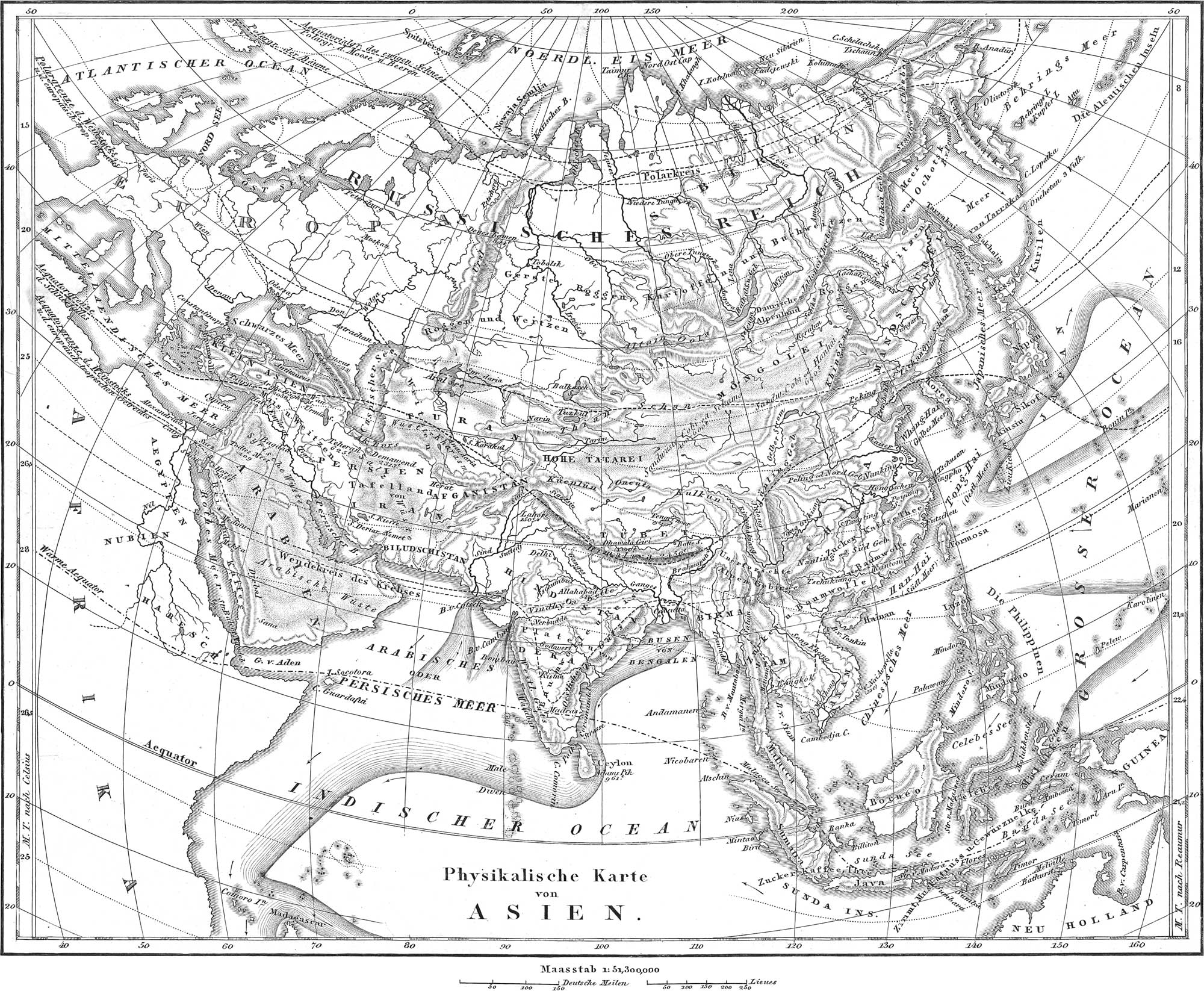
The continent of Asia, the largest part of the world, embracing about 12,000,000 square geographical miles, and about 16,000,000 statute miles (according to other estimates, 14,128,000), lies entirely within the northern hemisphere. It is connected to Europe along a line of about 2000 miles, and to Africa by an isthmus of only 60. Behring’s Straits separate it from America. Its greatest length, from Suez to Bhering’s Straits, is about 7370 miles; and its greatest breadth, from Cape Comorin in India to Cape Taimurski in Siberia, about 4320. It is included between 1° and 77° N. Lat., and 26° and 170° longitude east of Greenwich.
The Seas washing the shores of Asia are the Arctic Ocean in the North, formino; the Gulfs of Obi and Kari: in the south, the Indian Ocean with numerous gulfs and bavs, as the Persian Gulf, the Gulf of Cutch, the Gulf of Cambay, the Arabian Sea, the Gulf of Manaar, the Bay of Bengal, the Gulf of Siam, the Gulf of Tonquin, the Chinese Sea, the Gulf of Hoang-hai or the Yellow Sea, the Sea of Japan, the Sea of Okotsk, the Sea of Penjinsk, and the Sea of Eehring or Kamtschatka.
The Mountains of Asia may be arranged in the following manner, although much still remains to be known respecting them.
- The mountain chain of the desert of Cobi. in the middle of Asia, inclosing an area of over 1000 miles in length, and 200 to 400 miles in breadth, better known as Central Asia. The Bolor or Beloot Tagh Mountains form the western border, attaining a height of over 20,000 feet; the north-eastern border is constituted by the Thiam-shan or Celestial Mountains, and the Altäi chain dividing into the west and east Altäi, the latter connected with the Yablonoi Mountains; the eastern border is formed by the Kinghan, and the southern by the Kuenlun or Chinese range, to which also belong the Kulkun and the Tsunglin Mountains.
- The Himalaya, south of the preceding, and connected to the north-west with the Tsunglin Mountains. The highest summits on the globe occur in these mountains, pre-eminent among which is Kunchinginga in Sikim, 28,178 feet high. Dwalagiri in Nepaul, until lately considereil as the point of maximum elevation, is 26,862 feet high. Juwahir in Kumaoon is 25,670, &c. In fact there are twenty-two peaks of the Himalaya, each known to exceed 20,000 feet in height. The highest pass of this range is the Karokorun Pass in Tibet, 18.600 feet. The mean height of the Himalaya has been variously estimated from 11,000 to 16,000 feet.
- The Ural Mountains form the natural boundary between Europe and Asia. They extend from Ustart as the southern limit between the Caspian Sea and the Lake of Aral, to the Gulf of Karskair (or Karia) in the Polar Sea. They attain a height of 5397 feet in the Kondjakowskoi-Kamen Peak.
- The mountains of Hindostan. namely the Ghauts and the Vindhya. The former divide into the West Ghauts, which extend for a length of 800 miles along the western coast, and attaining; a height of 8760 feet in the Neilglierries; and the much less elevated East Gliaüts, separated from the other branch by the Deccan.
- The mountains encircling the table land of Persia or the plateau of Iran, of a height of from 4000 to 7000 feet above the sea. This is bounded to the north by the Hindukhos, which is the western continuation of the Himalaya, attaining a height of over 20.000 feet, and connected through the Parapomisan chain with the mountains of Elbruz on the southern extremity of the Caspian Sea (Damavend, the loftiest peak of the Elbruz. 15,000 feet high). To the east of the table land of Persia is found the Indo-Persian mountain boundary, with a peak, Sufeid Kho, 15,000 feet high; also the Soliman chain and the Brahu Mountains. In the south-vrest is a range of 120 to 200 miles broad, connected with the Elbruz, and parallel with the south western shore of Iran; this attains a height of 13,000 feet in Mount Sevellan, east of Tauris.
- The mountains of Armenia and Koordistan, forming the water-shed between the Persian Gulf, the Black, and the Caspian seas. The highest mountain in Armenia is the time-honored Ararat, 17.112 feet high. Branches of the Armenian mountains are: 1. The Caucasus, between the Caspian and Black seas, 120 to 200 miles louir. and attaininf? a height of 18.493 feet in Elbruz. 2. The Antitaurus (highest point Argneus, 13,197). 3. The Taurus, in Asia Minor, connected with the preceding. Single mountains of Asia Minor are Olympus, Ida, Tmolus, &c.
- The mountains of Lebanon in Syria. divided by the valley of Cœlo-Syria into Lebanon proper and Anti-Lebanon, are connected towards the south with the mountains east and west of the Jordan: among these are Tabor, Carmel, Gilead, &c. The elevation of Lebanon proper is 9517 feet.
- Sinai and Horeb on a small peninsula in the north-west of Arabia, the former 7498 feet, the latter 8593 in height.
The most important Capes and Promontories of Asia are: 1. Ras-el-Gad, the south-eastern point of Arabia. 2. Ras Muhammed, the southern point of the peninsula of Sinai. 3. Cape Comorin, the southern point of Hindostan. 4. Cape Romania, the southern point of the Malayan Peninsula, and the extreme southern point of the mainland of Asia. 5. Cape Cambodja, the southern point of the eastern part of Further India. 6. Cape Lopatka, the southern point of Kamtschatka. 7. The East Cape or the Promontory of Tschuktschen, the most eastern point of Asia. 9. Cape Taimura or Siwero Wastotschnoi, the most northern point of Asia.
The most extensive Plains and Deserts of Asia are: 1. The Desert of Cobi, having in its centre a sandy tract of from 80 to 200 miles in breadth, and 2500 feet high, called Schamo, or Hanhai, bordered to the north and south by two rocky and elevated plains of about 3600 feet in height. 2. The great Indian Desert of Scind, in Eastern India, 440 miles long, and 320 broad. 3. The plateau of Iran. 4. The great Desert of Tartary. 5. The Syro-Arabian Desert. The entire area of all these deserts is probably fully equal to that of the whole of Europe.
The Rivers of Asia emptying directly into the sea are:
- Those of the Indian Ocean. Into the Persian Gulf empty the Euphrates and the Tigris, which, by their union, constitute the Ghat-el-Arab, or the Arabian River; along the west coast of Hindostan empty the Indus, Nerbudda, and Tapti; along the east coast of Hindostan empty the Kaweri, Krischna, Godawery, and Mahanudy; into the Bay of Bengal empties the Ganges, to which is united the Brahmaputra, shortly before: the Irawaddy, the Thaluen, and the Tanasserim. discharoje their waters along; the western shores of Further India.
- Into the Pacific Ocean there empty, along the eastern coast of Further India, the Menam and Cambodja; in China the Yantsekiang, or Blue River, and the Hoangho, or Yellow River; in Mandschurei, the Amur, arising from the confluence of the Argun and the Schilka; in Eastern Siberia the Anadyr.
- Into the North Polar Sea, or Arctic Ocean, empty the Kolyma, Indigirska, Jana, Lena, Jenisei, and Ob.
- Into the Black Sea empty the Kuban, Phasis (now called Rion), Halys (Kisil-Irmak), Sangaris (Sakarja).
- Into the Sea of Marmora, the Granicus, important only in an historical point of view.
- Into the Mediterranean empty, on the west coast of Asia Minor, the Scamander, Hermus, Caystrus, and the Meander; on the south coast of Asia Minor, the Cydnus; and the Orontes, the Leontes, the Belus, and the Kison, on the coast of Syria and Palestine.
Numerous rivers empty into the inland seas, of which latter, the Caspian, 640 miles long, and from 100 to 240 broad, is by far the largest. Along its northern shore empty the Ural and the AYolga; along the western coast the Kuma, Terek, and Kur. Besides this there are discharged into the Aral Sea the Gihon (Oxus) and the Sihon (Jaxartes); into the Dead Sea the Jordan, Kedron, and Arnon. Other lakes are Baikal, Balkasch, Urmia, Wan, Zareh, Lop, &c.
Asia possesses numerous Islands, the principal of which are distributed as follows. 1. In the Indian Ocean: the Laccadives, the Maldives, the Andamans, the Nicobar Islands, and the great island of Ceylon, of about 16,000 square miles, and containing a mountain, Adam’s Mountain, 7420 feet high. 2. Between the Indian and Pacific Oceans: the great Isles of Sunda, namely, Borneo, Sumatra, Celebes, and Java, together with the lesser Isles of Sunda, and the Moluccas or Spice Islands. 3. In the Pacific Ocean: the Philippines, of which Manilla or Luzon, and Mindanao, are the largest; the Chinese islands, among them Hainan and Formosa; the Japanese Islands, the largest of them Nipon and Jesso. The Kurile and the Aleutian Islands between Asia and America. 4. In the Arctic Ocean: Novaja Semlja, Spitzbergen, and New Siberia. 5. In the Mediterranean, not far from the coast of Asia Minor, lie Cyprus, Rhodes, Chios, Samos, Lesbos, Tenedos, &c.
The Isothermal Lines of Asia are given on her physical chart (pl. 4). One of these is m[a]rked · — · — · — · — ·, and is indicated as the equator of heat (Wärmeäquator); by this is to be understood that isothermal which corresponds to the greatest observed mean temperature of about 82° F. It will be seen that this is far from coinciding with the terrestrial equator. The chart also expresses the equatorial limit of perpetual snow, and of the falling of snow; these show how for to the south perpetual snow lies in different countries, and how far it falls during winter. The former line coincides with the polar limits of mosses and berries.
The chart likewise indicates the limits of different kinds of plants, among which, in addition to the various cerealia, are to be found the sugar-cane (Zucker), coffee (Kaffee), tea (Thee), cotton (Baumwolle), rice, &c.; also, the polar limits of trees, the equatorial and polar limits of the vine, and of the European tropical cerealia.
Africa

This still, for the most part, unknown portion of the earth, extends from 37° 20′ north latitude to 34° 50′ south latitude; its limits in longitude are 51° 22′ east, and 17° 32′ west longitude, reckoned from Greenwich. Its greatest length is 5000 statute miles; its greatest breadth about 4800. It contains about 8,902,000 square geographical, or nearly 12,000,000 statute miles. It is bounded on the north by the Mediterranean Sea, on the west by the Atlantic, on the south and east by the Indian Ocean; to the north-east it is connected to Asia by the Isthmus of Suez, and is separated from Europe to the north-west by the Straits of Gibraltar.
The portion of the Atlantic Ocean washing the south-western part of Africa, is the South Atlantic, the northern part of which is termed the Gulf of Guinea. Smaller portions of the Gulf of Guinea are the Bights of Benin and Biafra. The small portion of the Indian Ocean which separates the Island of Madagascar from the mainland of Africa, is called the Mozambique Channel. Between the north-eastern coast of Africa and the western coast of Arabia, the Indian Ocean runs up in a long, narrow gulf, the Arabian gulf, or the Red Sea; this is connected with the main ocean by the Straits of Bab-el-Mandeb. The northern extremity of the Red Sea is called the Gulf of Suez. In the northern part of Africa the Mediterranean forms the Gulfs of Sidra, Cabes, and Tunis.
Among the Currents of the African seas, as represented on our physical chart of the Continent (pl. 5), the following are the most important: Two currents from the Indian Ocean (one of them much the stronger of the two, coming through the Mozambique Channel) unite not far from the southern point of Africa, and there constitute a current from 360 to 400 miles broad (the Cape current), which soon after takes a north-westerly direction, with a mean velocity of about twelve miles per hour. From this branches off the South Atlantic current, which passes along the western coast of South Africa, and subsequently, when the coast takes a direction to the west, continues westward along the equator. It now forms the main Equatorial current, but between it and the coast there runs another current from north to south, nearly in the opposite direction, and known as the Guinea current. The Equatorial current continues its course on both sides of the equator, and at a degree of latitude corresponding to about 20° west of Greenwich, separates into a northern and west-south-western branch, of which the latter again bifurcates. The Guinea current already mentioned is only part of the great North African current which passes southwards along the western end of the Desert of Sahara. The South Atlantic connecting current carries the waters of the Atlantic and Pacific Oceans into the Indian Ocean; little, however, is known of its extent and direction.
Very little is known of the Mountains of Africa. The following are the principal, as far as ascertained:
- The Atlas, in the western part of North Africa. The most western part is the High Atlas, which, in Morocco, attains an elevation of 15,000 feet, and is covered with perpetual snow; the eastern and northern part along the Mediterranean is called the Lesser Atlas, the most southern part the Great Atlas. Eastern continuations are the Ghariano and Soudah Mountains. East of the great Gulf of Sidra, the Plateu of Barca elevates itself to a height of some 1600 feet. The left bank of the Nile is occupied by the Libyan chain.
- In Middle Africa we find the Abyssinian Alps, not far from the Red Sea, and sometimes called tha Samen Mountains; to the south these are connected with the Mountains of the Moon (Dschebel el Kamar). and the Barakat Mountains.
- In South Africa the mountains of the Cape are conspicuous for their elevation, and consist of three parallel ranges. The first, Lange Kloof, runs parallel to the coast; the second is the Zwart Berg; and the third is the Nieuweveldt’s Gebirge, the highest of all (over 10,000 feet).
The principal Capes are: 1. On the north coast: Capes Spartel, Bugarona, Farina, Bon, Rasat. 2. On the west coast: Capes Cantin, Ger, Nun, Bojadore, Laguedo, Blanco, Mirik, Verde (westernmost point of Africa), Roxo, Verga, Sierra Leone, Mesurado, Palmas, Three Points, Coast Castle, St. Paul, Formosa, St. John, Lopez, Gonsalvo, Padron. 3. On the southern coast: Cape of Good Hope, Aiguilles, Infanta, St. Franciscus, Recife, Morgan. 4. On the east coast: Corrientes, Delgado, Guardafui (the easternmost point of Africa).
Among the innumerable plains of Africa, by far the most extensive even in the world, is the Great Desert of Sahara, 2500 miles long, and 800 broad, containing 2,000,000 square miles of area. The fertile spots, like islands, which are distributed through the Desert, are called Oases; the largest of these is the Oasis of Fezzan. The eastern part of Sahara is called the Libyan Desert, separated from the Nubian Desert by the river Nile; the western portion, which is the true Sahara, contains but few oases.
The Rivers of Africa are:
- Those emptying into the Mediterranean. The most important of these is the Nile, formed by the junction of the Blue River (Bahr el Azrek) and the White River (Bahr el Abiad). It is 2700 statute miles long, and empties into the sea by two arms (formerly by seven) forming the Delta of the Nile. From August to October of each year, it rises from twenty to twenty-five feet, and fertilizes the adjoining country by its overflow.
- Rivers emptying into the Atlantic. These are the Senegal, the Gambia, the Rio Grande, the Niger (emptying by numerous arms into the Bight of Renin, and there constituting an immense Delta), the Congo or Zaire, the Cuenza or Coango, and Orange River or the Gariep.
- Into the Indian Ocean there empty only inconsiderable rivers, the only ones deserving mention being the Lorenzo-Marquez, the Zambeze, and the Quilmance.
Africa possesses but few inland Lakes. The largest, as far as known, is Lake Tschad, situated in the interior, at an elevation of about 1400 feet, and into which flow various rivers, as Yeou, Shary, &c. In the north-east of Africa we find Lake Zana in Abyssinia, through which the Nile flows; south-east of this is the Zawaja; also Lake Moeris (Berket el Kerun) and the Natron lakes in Egypt; and the Moravi or Zembre lake in the south-east. The elevated Lake Koufia is situated to the north-west of the latter.
Islands. 1. To the east of Africa: Socotra, in the south of Arabia; the Seychelles or Mahe Islands, south of the equator, with the Almirante Islands, together forming the Ethiopian Archipelago; Madagascar, the largest of all the islands of Africa, containing about 160.000 square miles, and separated from the mainland by the Channel of Mozambique; the islands of Comoro and Primeira, in the Channel of Mozambique; and the Mascarene Islands to the east of Madagascar, among which are included the Mauritius (Isle ot France) and Bourbon. Upon the latter is a mountain of more than 10,000 feet in height.
2. In the west of Africa, a. North of the equator: the Azores or Terceiras (among them St Michael, Terceira, Flores, Pico, &c.), Madeira, the Canary Islands, Ferro, Palma, Teneriffe, with its peak of 12,172 feet in height; the Cape de Verde Islands, the largest of which is St. Jago, with the volcano of Fuego, 9154 feet high; the Guinea Islands, of which Fernando Po, Prince’s Island, and St. Thomas lie north, and Anabon south of the equator, b. South of the equators Ascension, St. Helena, and Tristan d’Acunha.
The Isothermals of Africa are shown on the chart. The equator of heat, or the isothermal of 82° F., passes through the middle of Africa, and the equatorial limit of snow through the northern part of Africa, Algiers, Tunis, and Morocco. The southern limit of the vine passes a little further south, through Egypt, (fee.; through South Africa passes the south polar limit of the banana, and of the tropical grains; also the equatorial limit of the European tropical grains; still further south is the polar limit of the palm.
America


The continent of America is divided into two portions, called North and South, by a narrow strip of land, the Isthmus of Panama. North America lies between 8° and 72° of north latitude, and 55° and 188° of longitude west of Greenwich. Its greatest length from Cape Lisburn in Russian America, to Cape Sable in Florida, is about 4260 miles; but a somewhat winding line, extending from the Isthmus of Panama to the Arctic Ocean, west of Mackenzie River, will not fall far short of 5900 miles. Its greatest breadth between 62° and 74° is nearly 3000 miles. It contains about 7,400,000 square statute miles.
South America extends from 12° N. latitude to 56° S. latitude. Its greatest length amounts to 4550 miles, the greatest breadth to 3200: the area included is 6,300,000 square statute miles, being thus over 1,000,000 of square miles less than North America. For the sake of conciseness we shall consider the entire Continent as a whole.
The northern part of the Continent is bounded by the Arctic Ocean, and the vast space between it and the Atlantic is occupied by Baffin’s Bay, with its strait (Davis’s), and Hudson’s Bay, with James Bay in its southern part, and communicating with the Atlantic by Hudson’s Strait.
The principal indentations of the Atlantic Ocean are the Gulf of St. Lawrence, Bay of Fundy, Massachussetts Bay, Narragansett Bay, Delaware Bay, Chesapeake Bay, the Gulf of Mexico, and the Caribbean Sea, with their various bays, Campeachy, Honduras, Darien, Maracaibo, &c.
On the Pacific side we find Behring’s Sea, or the Sea of Kamtschatka, between America and Asia, connected with the Arctic Ocean by Behring’s Straits; Bay of San Francisco; Gulf of California; Bay of Panama; Gult of Guayaquil; and the Straits of Magellan, separating the mainland of South America from Terra del Fuego.
We have already referred to the principal current of the Atlantic Ocean, as coming from Africa, and dividing in the vicinity of Cape St. Roque, one branch going north towards the West Indies, another south along the coast of Brazil. The former passes through the channels of the lesser Antilles into the Caribbean Sea. A most remarkable current, known as the Gulf Stream, passes out from the Gulf of Mexico towards the north-east, and is conspicuous on account of the high temperature of its waters. Among the currents of the Pacific we may mention the cold Peruvian current, passing along the west coast of South America, from south to north. South of Cape Horn a constant current passes from west to east, from the Pacific to the Atlantic Ocean. The currents of the North Pacific have not yet been satisfactorily ascertained, although a constant stream is known to flow south, along the coast of California.
- The loftiest Mountains on the continent occur in South America. Here, for example, we find the Cordilleras, which traverse the whole of South America from north to south. The highest peak is Aconcagua in Chili (23,910 feet). ChimborazO; long considered the highest mountain of America, is exceeded by several other peaks; it is about 21,424 feet high. Cayambe, near the equator, has an elevation of 19,535 feet; Antisana, 19,137; Cotopaxi, 18,875; Pinchincha, 15,924; Tunguragua, 16,424.
- The Brazilian Mountains, which run parallel with the coast, and bear different names, as Sierra do Mar, Sierra Mantequeira, Sierra Espinhaço, &c. They extend along a distance of about 2000 miles, scarcely ever attaining a height of over 6000 feet.
- The Oronoco Mountains, in the north-eastern part of South America.
- The Rocky Mountain range of Mexico and North America. With this is associated a lofty table-land, beginning at the Isthmus of Tehuantepec, and extending north-west to the parallel of 42°. It is of greatest breadth (360 miles) and height in the latitude of the city of Mexico, at which place it is 7430 feet above the level of the sea. In the vicinity of the city of Mexico are situated numerous volcanoes, pre-eminent among which are Popocatepetl, 17,884 feet; Orizaba 17,374; and Iztascihuatl, 15,705 feet above the level of the sea. The mountain system of North America proper is one of no little complexity. The Rocky Mountains, as the central range, extend to the mouth of Mackenzie River; a second great range extends from the Peninsula of California to Russian America, leaving only two gaps for the passage of the waters along the west side of the Rocky Mountains, which are occupied respectively by the Columbia and Frazer’s rivers. It possesses several peaks more lofty than those of the Ptocky Mountains, among which are some active volcanoes. This range in California is known as the Sierra Nevada. Immediately along the coast of California is a range of mountains, known as the Coast Mountains, and separated from the preceding by the valleys of the Sacramento and San Joaquin. It is pierced by the Bay of San Francisco. About the latitude of 42° a chain of mountains extends east and west, between the Sierra Nevada and the Rocky Mountains, forming the northern boundary of the Great Western Basin of North America. This basin is about 500 miles in diameter each way, and contains its own system of lakes and streams, without any connexion with the sea. Many of these lakes are salt; the most remarkable are the Great Salt Lake (Timpanagos of Humboldt) and Utah. The Ozark Mountains, which run from Texas to the Mississippi, may be considered as an offset from the Rocky Mountains. The highest summits in the mountains of Western North America are Mount St. Elias, 16,775 feet; Fremont’s Peak, 13,570; Mount Brown, 16,000; Momit Hooker, 15,700 feet: Long’s Peak, 13,470; James’s Peak, 11,500, &:c. Some of these estimates are doubtless incorrect.
- The Alleghany Mountains, which occupy the region east of the Mississippi River, have for their base a strip of table-land, extending from Alabama to the mouth of the St. Lawrence. This high land is traversed throughout 1000 miles, from Alabama to Vermont, by from three to five parallel ridges of low mountains, rarely more than from 3000 to 4000 feet high, and separated by fertile longitudinal valleys. The Alleghanies proper are, however, restricted to Pennsylvania and Virginia. The chain is well characterized by the parallelism of the ridges, and the uniform level outline of their summits, with but few indentations. To the south they maintain a distance of 200 miles from the Atlantic: further north, however, they approach closer to the coast, as in the south-eastern part of New York, whence their course is nearly north towards the St. Lawrence. The most eastern ridge is continued in the double range of the Green Mountains to Gaspe Point in the Gulf of St. Lawrence. Branches extended as high as Baffin’s Bay. The highest point in the chain is Black Mountain, 6476 feet. Next to this are Mount Tahawus, or Marcy, 5344 feet; and Mount Washington, 6225.
Capes.1. In South America: Point Salinas, to the "north; Cape Boque, or Point Toira, in Brazil, the most eastern point; Cape Forward, the most southern point of the main land; Cape Horn, the southernmost point of America, on the island l’Hermite: Cape Blanco in Peru. 2. North America: a, on the Pacific; Cape Corrientes in Mexico. Cape St. Lucas, the southern point of Lower California; Cape Mendocino, Cape Gregory, Cape Lookout, Cape Flattery, Cape Newenham, and Cape Prince of Wales, b. In the Arctic Ocean: Cape Barrow, Cape Dalhousie, Cape Bathurst, Cape Parry; Point Turnagain, Cape Franklin: Cape Liverpool, Cape York, c, In the Atlantic Ocean: Cape Farewell, the southern point of Greenland; Cape Charles in Labrador; Cape Baze in Newfoundland; Cape May, Cape Henlopen, Cape llatteras, Cape Lookout, Cape Fear; Cape Sable, the southern point of Florida; Cape Catoche, the northern point of Yucatan.
Among the Plains of America may be mentioned the immense Pampas of Brazil, especially those on the western bank of the La Plata, extending from 20° to 40° south latitude, and abounding in salt and saltpetre: 2, the wooded plains (Selvas) of the Amazon, from 4° north latitude to 15° south latitude; 3, the grass-covered Llanos of the Oronoco; 4, the Prairies of the Mississippi, nearly as large as the whole of Europe, and partly covered with high grasses; 5, the plains of Canada.
Rivers. I. Those of South America emptying into the Atlantic Ocean: 1. the La Plata, arising by the confluence of the Paraguay, the Parana, and the Uruiruay, 1920 miles long: 2. St. Francisco in Brazil, 1400 miles; 3, the Amazon, or Maranhon, in Brazil, 3080 miles long, traversing the whole breadth of South America, and receiving in its course above sixty considerable rivers; it is from 4000 feet to twelve miles wide (forty-eight at the mouth of its long arm, and twenty at that of the south); 4, the Oronoco, 1200 miles long, emptying into the ocean by forty arms: 5, the Magdalena in New Grenada, 800 miles long.
II. In North America. A. Emptying into the Atlantic Ocean: 1, the Rio del Norte, or Rio Grande; 2, the Mississippi, 2896 miles long from the Gulf of Mexico to its source above Itasca Lake, and 3610 miles from the mouth to the head of the Missouri, thus forming the longest river in the world; 3, the Alabama; 4, the Apalachicola: 5, the Suwanne, all emptying into the Gulf of Mexico; 6, the St, John’s; 7, the Altamaha; 8, the Savannah; 9, the Cape Fear; 10, the Roanoke; 11, the James; 12, the Potomac; 13, the Susquehanna; 14, the Delaware; 15, the Hudson; 16, the Connecticut; 17, the Kennebec; 18, the Penobscot; 19, the St. Lawrence. Numerous rivers of considerable size empty into Hudson’s Bay. as Nelson, Churchill, &c.
B. Into the Arctic Ocean there empty Back’s, or Great Fish River, the Coppermine, and the Mackenzie.
C. Into the Pacific there empty the Columbia or Oregon, the Sacramento and Joaquin, the Colorado and the Gila, and some smaller streams.
Lakes. 1. South America has but few lakes, and those of small extent; the largest are Titicaca in Peru, area 1000 square miles, and Lake Maracaibo (area 1200 square miles) connected with the Gulf of Venezuela.
2. In Central America, Lake Nicaragua.
3. In North America: Lake Superior, 35,000 square miles; Lake Huron, 20,000; Michigan, 25,000; Erie, 10,000; Ontario, 8,200. All of these are connected in one continuous series, discharging their waters through the St. Lawrence River. Lake Champlain, 900 square miles, is an offset of the same system: Lake Winnepeg, 12,500, drained by Nelson’s River; Great Slave Lake, 13,500: Athabasca, 3500; and Great Bear Lake, 9000 square miles; all these empty into the Arctic Ocean by Mackenzie River. The Great Western Basin contains two remarkable lakes, one (the Great Salt Lake) about seventy miles long, with its waters saturated with salt; the other, and connected with the latter, Utah Lake, containing fresh water. It is between these two lakes that the Mormons have established the nucleus of their new State of Deseret.
Islands, A. In the Atlantic: a, North America. Southampton in Hudson’s Bay; Anticosti, Prince Edward’s, and Cape Breton, in the Gulf of St. Lawrence; Newfoundland, Long Island, and the Bermudas. b, West Indies. The Bahamas, among which is San Salvador or Guanahani, discovered by Columbus in 1492; the four greater Antilles, viz. Cuba, 43,380 square miles; Hayti or St. Domingo, 29,400; Jamaica, 5,520; and Porto Rico, 3865; the lesser Antilles, which constitute an arc, extending from Porto Rico to Trinidad. The largest are Trinidad, Guadaloupe, Martinique, Barbadoes, Tobago, Dominica; Margarita, Curacao, and others, lie on the north coast of South America, c. South America. Fernando de Noronha and Trinidad on the coast of Brazil: the Falkland Islands; Terra del Fuego, Staten Land, l’Hermite, and others to the south of South America; New or South Georgia, Sandwich Land, South Shetland, and the South Orkneys.
B. In the Pacific Ocean: a, North America. Kodiak, Sitka, Washington or Charlotte, Vancouver, Prince of Wales, &.c. b, South America, The Gallapagos, San Felix, Ambrosia, Juan Fernandez, De la Campana, Madre de Dios, the Chiloe Islands.
C. In the Arctic Ocean: Melville Islands, Discoe, &c.
D. In the Antarctic Ocean: there are obscure indications of islands in the Antarctic Ocean, some of which are probably portions of an Antarctic continent.
For the explanation of isothermal lines, and of the lines marking the boundaries of various plants, as marked on the physical charts of North and South America, we would refer our readers to the article on Europe.
Australia

Australia, sometimes called Australasia, is the name given to an assemblage of huge insular masses of land, occupying the western parts of the Pacific, and extending southwards from Eastern Asia. These great oceanic tracts consist of: 1, New Holland, often called Australia; 2, Van Diemen’s Land; 3, New Zealand; 4, Papaa; 5, New Britain, New Ireland; 6, Solomon’s Island; 7, New Hebrides; 8, New Caledonia; 9, Polynesia. Of these New Holland is by fair the most extensive, embracing an area of nearly 3,000,000 square miles, with a length of 2600 miles from east to west, and 2000 from north to south. It is included between 10° 30′ and 39° south latitude, and between 112° 20′ and 153° 40′ longitude, east of Greenwich. It is watered partly by the Indian, partly by the Pacific Ocean. The former indents the north shore in the Gulf of Carpentaria, and separates the Continent from Papua or New Guinea, in Torres Straits. Bass Strait separates it to the south from Van Diemen’s Land.
Little is known of the Mountains of New Holland, excepting that they constitute a rocky wall running nearly round the whole island. Their highest summits do not appear to exceed 3000 feet. Mount Kosciusko is said to be the loftiest, next to which come Mounts Bellenden, Elliot, Abbon, Mitchell, Cockburn, Rugged, Sterling, and Round Mountains.
The principal Capes are Wilson’s promontory, the extreme south point. Cape Leeuwin (south-western point), Cape Escarpee (westevn point). Cape Grenville (northern), and Sandy Cape (most eastern point).
The principal Rivers on the eastern coast are the Brisbane, the Hastings, and the Hawksbury; on the south coast, the Murray, with its tributaries, the Morumbidgee and Darling; on the western coast. Swan River.
Van Diemen’s Land lies to the south of New Holland, of which it may be considered an island. It contains an area of 27,192 square miles. New Zealand comes next in point of importance, ranging parallel to the south of New Holland, with a broad intervening expanse of ocean; area 62,160 statute square miles. Papua is the largest mass next to New Holland, being from 1200 to 1400 statute miles in length, and varying from 150 to 200 miles in breadth. It possesses various mountains of great elevation. New Britain and New Ireland are the largest of a group of islands beginning at the north-eastern boundary of New Guinea, and ranging in a circuitous line parallel to New Holland. The area has been estimated at 16,000 statute square miles. Solomon’s Islands form an archipelago lying east of New Guinea. The New Hebrides are situated to the south-east of the preceding. New Caledonia is a large island 250 miles long and sixty broad, forming the southern termination of the great chain of archipelagoes to the east of New Guinea and New Holland.
The islands constituting the extended group called Polynesia, although in all strictness excluded from Australia, may yet be considered in this place for the sake of convenience. First among them are the Society Islands, including Tahiti, Eimeo, Ulietea, Huahine, &c. The Paumotu group is a series of very low coral islands, extending E.S.E. from the Society Islands. Pitcairn’s Island, Easter Island, and Cook’s Island, are of small size. The Sandwich Islands constitute a solitary group far north of the main range. They are ten in number, of which eight are habitable. Of nearly 7000 square miles contained in the whole, Hawaii alone embraces 4,500. The others are Maui, Oahu, Tauai, Molakai, Ranai, Niihaw, Tahawrowa. We have only room to mention the names of the remaining clusters: they are the Mendana Archipelago, including the Marquesas and the Washington Islands; the Friendly Islands, or the Tonga Archipelago: the Fejee Islands, Navigators’ Islands, the Carolines, the Central Archipelago, the Pelew Islands, and the Ladrones or the Marianne Islands.
![]() Historical Geography
Historical Geography
 Historical Geography
Geography of Ancient Times

The first geographical accounts, or rather indications, are due to the oldest Greek poets, of whom Homer in particular presents us with numerous geographical and ethnographical accounts, for which reason he may be looked upon as the oldest geographer. He supposed the earth to be a circular disk, inclosed by a great body of water, the ocean. In its midst lay the mainland of Hellas. Above the earth was placed the brazen vault of the heavens, and beneath the earth a similar vault, inclosing Tartarus, or the lower regions, situated as far below the earth as this was below the heavens. Of all the regions of the earth, Homer was only acquainted to any extent with Greece and Asia Minor, although he refers to Thrace, Phœnicia, Egypt, Lybia, Ethiopia, and some few islands in Western Europe. Hesiod (800 B. C.) had more knowledge of this subject than Homer; in his writings we find the first mention of Modern Italy, as also of Spain, under the name of the Garden of the Hesperides. Æschylus and Pindar distinguished three parts of the world, bounded by the Phasis and the Nile. The philosophers of the Ionian school (founded by Thales of Miletus, 640–548 B. C.) endeavored to attain a knowledge of the shape and physical features of the earth by deductions from hypotheses; it was the school of Pythagoras, however, that first broached the idea of the sphericity of the earth. The so-called logographers, or the oldest Greek historians before Herodotus, extended the knowledge of geography to a considerable extent. Among them may be especially mentioned Hecataeus of Miletus (549–486 B. C). Certain projectors and historians of (at that time) great voyages of discovery, as Scylax (509 B. C.) and Hanno of Carthage (500 B. C), also deserve honorable mention. (For the idea of Geography, as possessed by the ancients, see pl. 8.)
Herodotus of Halicarnassus (484–408 B. C.) is, however, to be looked upon as the true father of ancient geography, having travelled extensively for years at a time, and published the results in historical works, many of which are still extant. He returned to the first idea of a terrestrial disk resting in the centre of the universe, and assigned to the disk an elongated or oval outline, and an encompassing ocean. A division into two great halves appeared to him more appropriate than that into three parts; these were separated by the Mediterranean, the Black, and the Caspian seas; the northern division included Europe with Northern Asia to the Phasis; the southern, the rest of Asia and that portion of it forming the peninsula of Libya (i. e. Africa). In his works we first find the name Italia. The last inhabited land of Europe, according to him, is Thrace. Scythia forms a square, each side of which amounts to 4000 stadia; to the north, next to Scythia, dwell the Agathyrsoi, Androphagoi, &c., and the Sauromatoi, north of the sea of Azof (Mseotis). Asia, separated from Europe by the Phasis, and divided by the Halys into two principal portions, is as large as Africa. Along the Mediterranean, inhabited by the Colchians, Saspeirians, Medes, and Persians, are two great peninsulas, the one containing Asia Minor, the other Persia, Syria, and Arabia. The latter is the most south-western land in Asia; India the most south-eastern land in the world. Africa, or Libya, was divided by Herodotus into three portions: the valley of the Nile or Egypt, Libya in its restricted sense, and the land of Ethiopia, or the most south-western inhabited region. (See the map of the world according to Herodotus, on pl. 8.)
After Herodotus, the following are the Greek authors who added to the science of Geography: Ctesias of Cnidos, whose works are lost; Thucydides, in his history of the Peloponnesian war; Xenophon, in the Anabasis and other works; Theopompus; Scylax, in his Periplus; Pytheas; Aristotle, who asserted the sphericity of the earth from observations on lunar eclipses, and on the general principles of Gravity; Theophrastus, &c.
Geography was first placed on a systematic basis by Eratosthenes of Cyrene (276–194 B. C.); he it was who wrote the first scientifically arranged work on the subject. This, however, has entirely disappeared, excepting a few fragments. He also constructed the first chart of the earth, accordino; to astronomical and mathematical principles. He considered the northern half of the earth to be alone inhabited, and supposed that the portion thus occupied amounted to about one eighth of the whole surface. He found an ardent opponent to many of his views in the great astronomer of antiquity, Hipparchus of Nicaea.
A new era in the history of Geography begins with Strabo (66 B. C. to 24 A. D.). To him we owe the first extensive and complete work on the science (in seventeen books), almost entirely extant at the present day. In its preparation he passed many years in study and travel. In his view, the whole earth is inclosed by a great Atlantic Ocean, which forms four large gulfs; the Caspian Sea, the Persian Gulf, the Arabian Gulf, and the Mediterranean, the largest of all. The great island of the earth he divided into a northern and a southern half, assuming, however, for greater convenience, three grand divisions, Europe, Asia, and Libya: the limits of those are the Straits of Hercules (Gibraltar), the Arabian Gulf, and the Tanais (the Don). Iberia or Spain lies furthest west. East of this is the land of the Celts or Gauls (France), between the Pyrenees and the Rhine, parallel to these mountains. Britain has the shape of a triangle, north of which is the island lerne (Ireland), the most northern part of the inhabited earth. Germany is only known at the mouth of the Albis or Elbe: further east, the entire northern coast of the earth is unknown. The Alps rise along the boundary between Gaul and Italy, and to them are opposed the Apennines. Asia, separated from Europe by the Tanais and Mseotis, is divided into a northern and a southern half by the mountains of Tauris. The largest and most eastern portion of the earth is India. Libya, which is not as large as Europe, and with Europe in addition, is less than Asia, is of a triangular shape, the northern shore along the Mediterranean constituting the base; Egypt and Ethiopia constitute its most eastern portion. (For a map of the world according to Strabo, see pl. 8.)
Among subsequent geographers, one of the most distinguished is Claudius Ptolemæus, who flourished about the middle of the second century, He wrote a geographical work, which up to the sixteenth century continued to be the universal manual. He presents to us the most advanced stage of the knowledge of Geography as possessed by the ancients. The chief peculiarities of the Ptolemaic system are as follows (see the map of the world according to Ptolemy on pl. 8). Ireland (luernia) is no longer to the north, but to the west of Britain (Albion); to the north of Albion lie the Orcades, and still further north the Island of Thule. Scandinavia (Scandia) is an island smaller than Ireland. Even the Danish islands are mentioned, as Jutland (the Cimbrian Chersonese). The Caspian (Hyrcanian) Sea is inland. Ptolemy extends Asia to the east far beyond the Ganges, and speaks of the land of the Sinse (Chinese). Asia and Africa, he supposed to be connected, the Indian Ocean intervening simply as a great Mediterranean sea. Ceylon (Taprobane) he imagined to be the largest island on the earth; next to it extended from north to south, a group of 1378 islands. He makes mention of the Mountains of the Moon and the sources of the Nile in the interior of Africa, the River Niger, &c.; and on the western coast he laid down the Happy Islands, through which he drew his first meridian.
In the time of Herodotus the measure of length employed was the stadium, or the length of the Olympian racecourse. Various estimates have been made of the exact length of the stadium. From the best sources of information it would appear that this, the longest measure of length made use of in classical antiquity, contained 600 Grecian or 625 Roman feet. As the Roman foot contains nearly eleven French inches, this would make the stadium 570\(\frac{1}{4}\) French or Paris feet, equivalent to about 607\(\frac{1}{2}\) English feet, or less than \(\frac{1}{9}\) of an English mile (\(\frac{1}{10}\) of an English geographical mile of 2025 yards). We may therefore count 600 stadia to a degree. A Roman mile contained 5000 feet, and was equivalent to eight stadia, so that 1\(\frac{1}{4}\) of these go to the geographical mile, and 75 to a degree of the equator. The Persian parasang has been estimated at thirty stadia or \(\frac{3}{10}\) of a geographical mile, so that there are twenty to a degree. An Egyptian schœnos contained two parasangs or sixty stadia; according to some authors, however, only thirty or forty. A gallic hour or leuga (leuca) contains 1500 Roman paces or twelve stadia: consequently, there are fifty to a degree.
The circumference of the earth, as is well known, amounts at the equator to 21,600 geographical miles, or 216,000 stadia. Eratosthenes estimated it at 252,000 stadia; Hipparchus at 275,000: Posidonius at first at 240,000, but subsequently at 180,000 stadia, or \(\frac{5}{6}\) of its actual size. The last-mentioned estimate was accepted by most of the subsequent astronomers and geographers, even by Ptolemy.
The Greek compass or wind card (on pl. 8, according to Aristotle) is divided into eight main winds, which, from west round by north, are as follows: Zephyros, Argestes, Boreas or Aparctias, Csecias, Apeliotes, Euros, Notes, Lips. Between Boreas and Argestes blow Thrascias or the north-north-west wind, and between Boreas and Csecias, Meses, or the north-north-east wind. Two additional winds were subsequently added to these ten; phœnicias or south-south-east wind, and Libonotos or south-south-west; the twelve winds then divided the card into equal parts, so that excepting the four main winds, the rest had an entirely different signification from those on our card. Vitruvius enumerates twenty-four winds (see the wind card of the Romans on plate 8).
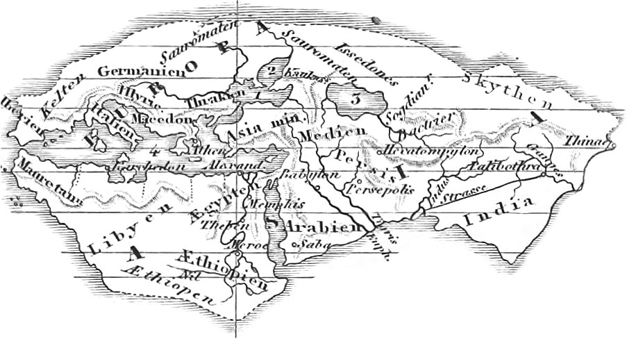
Plate 9 represents the kingdom of Alexander the Great. This renowned conqueror was originally only a king of Macedonia, a country of small extent, bounded on the east by Thrace and the Egaean Sea, south by Epirus and Thessaly, west by Illyria, and north by Dardania and Moesia; it now constitutes part of Turkey in Europe. Philip, the father of Alexander, had already subjected numerous Thracian, Illyrian, and Dardanian tribes, and in fact all Greece, by the battle of Chaeronea (338 B.C). Alexander, after ascending the throne in 336 B.C., conquered the Thracians, Triballi, Getas. and Illyrians, reduced Thebes, and first commenced his victorious career as Emperor of Greece, by his expedition against the Persians in 334 B.C. After the battle of the Granicus, he overran Asia Minor, passing through Syria, Phoenicia, and Palestine, to the borders of Egypt: Egypt he conquered without any difficulty, and founded, in 332, the city of Alexandria. After a pilgrimage to the Temple of Jupiter Ammon, in the Lybian desert, Alexander took up his march towards Central Asia, overthrew the Persian empire by the victory at Gaugamela or Arbela (331), and afterwards conquered Media, Parthia, Hyrcania, Margiana, Aria (329), Arachosia, Bactriana, and Sogdiana. In 327, Alexander crossed the Indus, Hydaspes, Acesines, and Ilydraotes, as far as the Hyphasis (Sudletsch), until his warriors refused to go any further. He now returned by another route to the Hydaspes, embarked on the Acesines. and passing into the Indus, ultimately gained the great ocean. Erom the mouth of the Indus he returned by land through the deserts of Gedrosia and Carmania (Nearchus conducting his fleet through the Indian Ocean, the Persian Gulf, and the Euphrates) to Babylon, where he died in 323. After his death his empire fell to pieces, forming several smaller kingdoms, as: 1, the Macedonian Greek; 2, the Syrian or kingdom of the Seleucidae (founded by Seleucus Nicator), which included the principal portion of the old Persian empire, and by whose downfall there arose various minor governments, as Bactria, Parthia, Armenia, Judsea, &c.; 3, the Egyptian empire under the Ptolemies; 4, Pergamos in Asia Minor, Pontus, Bithynia, &c. (See the small chart on pl. 9.)

Pl. 10 represents the Roman Empire under Constantine the Great. This monarch, in 330 A. D., divided his colossal dominions into four great prefectures: Italy, Gaul, Illyria, and the East. Each of these was divided into dioceses, which again were subdivided into provinces; of these there were 117 in all.
Italy the First Prefecture, consisted of three dioceses: Italy with Rome as its capital, Illyria with the capital Syrmium, and Africa with the capital Carthage. The Diocese of Italy was divided into three principal portions, Gallia Cisalpina (Upper Italy, excepting Savoy, but including a part of the Tyrol, and of Middle Italy); Italy proper (Middle Italy), and Græcia Magna (Lower Italy). In Cisalpine Gaul we have the provinces of Carnia (now Friaul, with the towns of Tergestum, now Trieste; Vedinum, now Udine; Aquileia): Venetia (towns Patavium, now Padua; Vicentia; Verona); Istria (Pola), Gallia Transpadana (Brixia, now Brescia; Cremona; Mantua; Bergamum, now Bergamo; Comum, now Como; Mediolanum, now Milan; Ticinum, now Pavia; Augusta Taurinorum, now Turin); Gallia Cispadana (Placentia, now Piacenza; Parma; Mutina, now Modena; Bononia, now Bologna; Ravenna); Liguria (Genoa; Lucca; Nicæa, now Nice). In Italy proper we have the following divisions: 1, Etruria, the present Tuscany, with a part of the Papal States (Pisa; Sena Julia, now Sienna; Portus Herculis Libronis, now Livorno: Perusia, now Perugia); 2, Umbria ( Ariminum, now Rimini; Sena Gallia, now Sinigaglia; Urbinum Hortense, now Urbino); 3, Picerium (Ancona); 4, Sabina, with the provinces of the Marsi, Peligni, &c.; 5, Latium (Rome; Tusculum, now Frascati; Tibur, now Tivoli: Præneste, now Palestrina; Terracina VelitrjTe, now Velletri; Cajeta, now Gæta). Groicia Magna, or Lower Italy, was divided into the following provinces; 1, Campania, now Terra di Lavoro (Capua Neapolis, now Naples; Herculaneum; Pompeii; Stabia; 2. the Land of the Picentini (Salernum, now Salerno): 3, Sainnum (Beneventum); 4, Land of the Hirpini, and 5, of the Frentani; 6, Lucania, now Basilicata and Principato citra (Pæstum and Sybaris, now "no longer in existence); 7, Bruttii, now Calabria (Rhegium, now Reggio); 8, Apulia (Venusia, now Venosa; Barium, now Bari); 9, Messapia or Calabria (Brundusium, now Brindisi: Ilydruntum, now Otranto; Tarentum, now Taranto). Here belong also the three great islands of Sicily (Messina; Catania; Toormina; Syracuse; Agrigentum, now Girgenti; Panorraus, now Palermo); Sardinia (Calaris, now Cagliari) and Corsica.
The Diocese of Illyria consisted of Illyria proper, or the east coast of the Adriatic Sea (now Dalmatia, most of Bosnia, and a portion of the present Croatia and Albania). Illyria was subdivided by the River Drilo into two parts, Barbarian and Grecian Illyria, the latter of which, with the cities of Durazzo and Albanoplis, was subsequently assigned to Macedonia; Barbarian or Roman Illyria consisted of the provinces Japydia, Liburnia, and Dalmatia. Pannonia, which included the eastern part of Austria, Styria, Carinthia, and Carniola, the whole of Hungary between the Danube and the Sau, Sclavonia, and parts of Croatia and Bosnia, was divided into upper (or western) and lower (or eastern). Particular provinces were Interamnia between the Sau and the Drau, Ripensis or Savia on the Sau, and the province of Valeria between Raab, the Danube, and the Drau. To Upper Pannonia belonged the cities of Vindobona (now Vienna), and Emona (now Laibach); to Lower Pannonia the cities of Arabona (now Raab). Acincum (now Ofen), Acimincum (now Peterwardin), Taurunum (now Semlin), Sinnium, the Largest town in Pannonia, now in ruins. Noricum divided into Noricum Ripense in the north, and Noricum Mediterraneum in the South, including the greater part of Austria, Styria, Carinthia, and Salzburg, and embraced the cities of Lentia (now Linz), Juvavia (now Salzburg), Noreja, Celeja (now Cilly), Laureacum (now Lorch). Here belonged in addition the following provinces: Vindelicia, subsequently called Rhsetia Secunda, including north-eastern Switzerland, south-eastern Baden, the most SDuthern portion of Wurtemberg and Bavaria, with the northern part of Tyrol, and Rhætia (Augusta Yiudelicorum, now Augsburg; Regina, now Regensburg or Ratisbon; Campodunum, now Kempten: Brigantium, now Bregenz: Batavia Castra, now Passau); Rhætia prima, now Graubünden and Tyrol, with a part of Lombardy (Tridentum, now Trient; Yeldidena, now Wilten; Teriole Oeni Pons, now Ipnspruck: Clavenna, now Chiavenna; Curia, now Chur).
To the Diocese of Africa belonged the following provinces; Cyrenaica or Pentapolis (Ptolemais, now Tolometa; Arsinae, now Tochira; Berenice, now Benegasi; Cyrcne the capital); Syrtica, or Tripolitana (with three capitals, Leptis Magna or Neapolis, now Lebida; Oea or Oeca, now Tripoli; Sabrata). Africa proper, or the province of Africa, divided into the districts of Byzacium in the south (Adrumetum; Tysdrus; Capsa) and Zeugitana in the north (Tunes, now Tunis; Carthage, once the capital of the mighty Carthagiuian nation, but long since in ruins; Utica next in importance to Carthage. Numidia, the present Algiers (Thabraca, now Tabarca; Hippo Regius, now Bona; in the interior, Zama, and Cirta, now Constantine). Mauritania divided into two provinces; the eastern, M. Cæsariensis (capital Cæsarea); and the western, M. Tingitana (capital Tingis, now Tangiers). Under Diocletian or Constantine, Mauritania Cagsariensis was divided into two provinces, Caesariensis in the west, and Sitifensis in the east: M. Tingitana was united with the Diocese of Spain.
The Second Prefecture of Gallia consisted of three dioceses; Gallia in its restricted sense, Hispania, and Britannia. Gallia (the present France, with Belgium, Holland, and parts of Germany, Italy, and Switzerland) was divided by the Emperor Augustus into the four provinces, Narbonensis, Aquitanica, Lugdunensis, and Belgica, which, however, were divided by Constantine the Great or even by Diocletian into fourteen, and still later into seventeen provinces. Gallia Narbonensis or Braccata, the oldest Roman province before the time of Julius Cassar, was separated into five provinces: Narbonensis Prima et Secunda, Alpes Maritimse, Viennensis, Alpes Graiæ, and Penninæ; it also included the provinces of Languedoc, Roussillon, Provence, Dauphiny, with the greater part of Savoy, Piedmont, and the cantons of Geneva and Yalais (Narbo Mantius, now Narbonne, the capital; Tolosa, now Toulouse; Massilia, now Marseilles; Telo Martius, now Toulon; A relate, now Aries; Geneva Valentia, now Valence). Aquitania was divided into the three provinces, Novempopulana, Aquitania Prima, and A. Secunda; it embraced the districts of Gascony, Beam, Auvergne, Guienne, Poitou (Burdigalia, now Bordeaux: Besunna, now Perifoux; Limonum, now Poitiers; Avaricum, now Bruges). Gallia Lugdunensis, previously Celtica, the largest of the four provinces, was divided into the four lesser provinces, Lugdunensis Prima, Secunda, Tertia, and Quarta, and included the provinces of Burgundy, Normandy, Brittany, Champagne, Maine, Touraine, Anjou (Lugdunum, now Lyons; Augustodunum, now Autun; Cabillonum, now Chalons on the Saone; Lutetia Parisiorum, now Paris; Kotomagnus, now Rouen; Genabum or Aurelianensis Urbs, now Orleans; Cæsarodunum, subsequently Turoni, now Tours). In conclusion, Gallia Belgica was divided into the five provinces, Belgica Prima et Secunda, Germania Prima et Secunda, and Maxima Sequanorum; it embraced the present Lothringia, a portion of Champagne, Picardy, Belgium, the left bank of the Rhine, southern Alsace,Tranche-comtc, and v.estern Switzerland. The most important towns embraced within these limits were in the land of the Helvetii, Lacus Lausonius, now Lausanne; Eburodurum, now Yverdum; Salodurum, noAV Solothurn (Soleure); Turicum, now Zurich: in the land of the Sequani, their capital Yesontio, now Besangon; Tullum, now Toul, in the land of the Leuci; Devodurum, now Metz, principal town of the Mediomatrici; Argentoratum, now Strasburg; Noviomagus, now Spires; Mogontiacum, capital of Germania Prima or Superior, now Mayence; Borbeto Magnus, now Worms; Augusta Trevirorum, capital of Belgica Prima, now Trier: Confluentcs, now Coblentz; Colonia grippina, now, Cologne; Bonna, now Bonn: in the country of the Batavi, called Insula Batavorum; Lugdunum, novr Leyden; Arenacum, now Arnheim; Noviodunum, now Nimwegen; Traiectum, now Utrecht; also Cortoriacum, now Courtray; Gesoriacum, subsequently Bononia, now Boulogne; Samarobriva, now Amiens; Csesaromagus, now Beauvais; Noviodurum or Augusta Suessonum, now Soissons; Durocortorum or Remi, now Rheims; Durocatelauni or Catelauni, now Chalons sur Marne.
The Diocese Hispania, including the present Spain and Portugal, was divided by Augustus into three provinces: Bsetica, Lusitania, and Tarraconensis. To these Constantine added the four provinces, Galhiecia, Carthaginiensis, Baleares, and Mauritania Tingitana in Africa. Bætica embraced the southern part of Spain, the present Andalusia, or the provinces of Sevilla, Granada, and Cordova, the western half of Jaen, the eastern part of the Portuguese province Alemtejo, and the southern part of Estremadura (capital Hispalis, now Seville). Other towns are Gades, now Cadiz; Corduba, now Cordova; Malaca, now Malaga. Lusitania, embraced the greater part of Portugal, and the Spanish provinces Estremadura and Salamanca (capital Augusta Emerita, now Merida; also Ebora, now Evora; Olisipo, now Lisbon, Salmantica, now Salamanca). Hispania Tarraconensis, the largest province, included the present Navarre, Arragon, and Catalonia, as also parts of Valencia and Castile: according to Pliny, it contains 179 cities (capital Cassaraugusta, now Saragossa; Carthago Nova, now Carthagena: Yalentia; Tarraco, now Tarragon; Barcino, now Barcelona; Pompelon, now Pampelona). Gallæcia embraced the Spanish province of Galicia, the Portuguese province Entre Douro e Minho, and the western part of Leon and Asturia, subsequently the whole of Asturia (principal towns, Braga; Brigantium, now Corunna). On the Balearic Islands (Major and Minor, now Majorca and Minorca) we find the towns Palnia and Pollentia, now Pollenza.
Of the British Islands, Britannia and Hibernia, the former only, and of that only the southern part of England, was in the possession of the Romans, who divided it into two provinces, Britannia Superior and Inferior (Scotland was known as Caledonia or Britannia Barbara). Four provinces were subsequently established: Britannia Prima, or the southern part; B. Secunda (Wales); Maxima Cagsariensis (the land between the Thames and the Ilumber); and Flavia Casariensis (the country north of the Humber to the Roman wall); to these was subsequently added a more northern province of Valentia. The principal towns of Roman Britain were Londinum or London; Amenta, now Winchester; Dunium, noAV Dorchester; Camalodunum, Colchester; Lindum, now Lincoln; Ratse, now Leicester; Eboracum, now York; Luguvallum, now Carlisle, &c.
The Third Prefecture of Illyricum (the eastern Illyria) included all the country of Greece to the Danube, excepting Thrace and the true Illyria; it consisted of the Diocese of Macedonia (capital Thessalonica) and Dacia. To the former belongs not only Macedonia proper, but also the whole of Greece; Macedonia proper being divided into two smaller provinces, Macedononia Prima, including the coast, country, and the western mountain region, and Macedonia Secunda or Salutaris. embracino; the northern mountain region; the capital of the former was Thessalonica, now Salonica, that of the latter, Stobi, now destroyed. Pella and Philippi are the only other towns worth mentioning.
Hellas, or Greece, was called Achaia by the Romans, and is naturally divided into three great sections. 1. Northern Greece, in the north of the isthmus of Corinth, and including the following provinces: 1. Thessalia, the largest of all the Grecian pro\inces (towns, Pharsalia Larissa; 2, Acharnania (towns, Ambracia, now Arta; Actium); 3, Ætolia (Elseus, now Missolonghi): 4. Doris; 5, Locris (Amphissa, now Salona; Naupactus, now Lepanto); 6, Phocis (Delphi, now Castri); 7, Bœotia (Thebæ, now Thiva; Platæa; Leuctra; Lebadea, now Lavadia: Chæronea; Coronea, near the present Granitza: 8, Attica (Athens, the capital of the kingdom of Greece, with the three harbors, Piræus. Munychia, and Phalerus); Megaris (Megara, the only city now a village of the same name). There also belongs here the province of Epirus, not included with Achaia (towns Buthrotum, now Butrinto; Nicopolis, now Prevesa; Anion or Aulona, now Balona). II. The Peninsula of Peloponnesus, subsequently called the Morea, and embracing the following ten provinces: 1, Corinthia. (capital Corinth); 2, Sicyonia (Sicyon); 3. Phliasia (Phlius); 4, Achaia (Patræ, now Patras); 5, Elis (Elis): 6, Messenia (Massene; Corona, now Coron; Methona, now Modon); 7, Laconia (towns Sparta or Lacedaemon, near the present Mistra); 8, Cynuria (Thyrea): 9, Argolis (Argos, still extant; Nauplia, now Napoli di Romania); 10, Arcadia (Megalopolis; Mantinea; Orchomenos). III. The Grecian Islands. In the Ionian Sea may be noticed, Corcyra, now Corfu; Paxi, now Paxos and Antipaxos; Leücas or Leucadia, now Santa Maura; Ithaca, now Thiaki; Cephallenia, now Cephalonia; Zacynthus, now Zante; Cythera, now Cerigo; Aegina, now Eghina. Eubœa, still of the same name, but formerly called Negroponte (towns, Chalcis; Eretria: Carystus: Histiæa). Crete was the largest of the islands of Greece; it was called Candia by the Turks (the Isle of Cyprus belonged to the Prefecture and Diocese of the East). Among the Cyclades, so called from their lying in a circle about Delos, may be mentioned Delos, Pares, Melos, Andros, Tenos, Syros, Myconos, Ceos, Naxos, Gyaros, Cythnos, Siphnos, and Seriphos. Among the Sporadian Islands were included: Thasos, Samothrace, Imbros, Lemnos, now Stalimene, los, Thera, Astypalgea, Amorgos, &c. The other Sporadian Islands, as Rhodes, belonged to Asia. To the Diocese of Macedonia also belonged the so-called Grecian Illyria, Illyria in its most restricted sense, likewise Epirus Nova, which embraced a large portion of Modern Albania. The capital was Epidamnus, subsequently called Dyrrhachium and now Durazzo.
The Diocese of Dacia included the central part of Mœsia, south of the Danube, and by Aurelian called Dacia Aureliani. In it was not included the true Dacia to the north of the Danube, embracing Hungary beyond the Theiss, Siebenbürgen, Bukowina, Moldavia, and Wallachia. Subsequently there was distinguished a Dacia Secunda, or Ripensis, the region along the Danube, from the Dacia Interior or Prima, the southern strip in the interior to the borders of Macedonia; also Dardania Prævalitana and Mœsia Prima.
The Fourth Prefecture of the East was divided into five dioceses: Thracia, Pontus, Asia, Egypt, and the Orient or East in its more restricted sense. The Diocese of Thracia. with Constantinople (previously called Byzantium) for its capital, embraced a large part of the present Turkey in Europe, and was subdivided into the provinces, Moesia Secunda, Scythia, Hæmimontus, Thracia, Rhodope, and Europa. In addition to the capital it contained the following towns: a, In Mœsia Secunda; Nicopolis on the Hsemus, now Nikopoli; Durostorum, now Süistria; Odessus, now Varna; b, in Scythia; Tomi, or Tomis, now Temeswar; Constantiana, now Costendsche; c, in the Hæmimontus; Adrianopolis, or Orestias, now Adrianople, or Edrene; d, in Thracia; Philippopolis, now Philippopoli; e, in Rhodope; Abdera, now Polystilo, or Asperosa; Ænus, now Enos; f, in Europa, besides Constantinople; Selymbria, now Selivria; Bisanthe, Rodosto, Perinthus.
The Diocese Pontus embraced eleven provinces; Bithynia, Galatia, Cappadocia Prima and Secunda, Paphlagonia, Honorias, Galatia Secunda, or Salutaris. Pontus Polemoniacus and Helenopontus, Armenia Prima and Secunda. Bithynia. the eastern part of which was named Honorias, had for its capital Chalcedon; Bithynium, subsequently Claudiopolis, was the capital of Honorias. Constantine divided Galatia into a northern part, G. Prima, and a southern, G. Secunda; Ancyra, now Angora, was the capital of the former, Pessinus that of the latter. Cappadocia, the most eastern province of Asia Minor, and now the Turkish province of Caramania, was separated into two provinces, Cappadocia Prima in the north, and Cappadocia Secunda in the south; the former had Caesarea (previously Mazaca) for its capital, and the latter Tyane, now Kills Hissar. Pontus, the most northern part of Asia Minor, included the present Pachalics of Trebisonde and Siwas; it was divided into an eastern part, P. Polemoniacus, and a western, Helenopontus (previously Pontus Galatlcus): chief towns, Trapezus, now Trebisonde, under Trajan, the capital of Pontus Cappadocius; Amasia, capital of Helenopontus; Neo-Cæsarea, capital of P. Polemoniacus. The Provinces of Armenia Prima and Secunda together, constituted Lesser Armenia.
The Diocese Asia or Asiana formed eleven provinces; Asia Proconsularis, Hellespontus, Insulæ, Pamphylia, Lydia, Caria, Lycia, Lycaonia, Pisidia, Phrygia Salutaris, and Pacatiana. The Province Asia Proconsularis included the western coast of Asia Minor, from Cape Lectum to the mouth of the Mseander, or the greater part of the old districts of Æolis and Ionia, with the neighboring parts of Mysia and Lydia (towns, Pergamum, now Pergama or Bergama; Smyrna, Clazomenæ, Colophon, and Ephesus). The Province Hellespontus embraced Troas and most of the northern parts of Mysia. The Province Insulæ included all the islands belonging to Asia Minor, with Rhodes, situated on an island of the same name, for the capital. The most important of these islands are: Tenedos on the coast of Mysia, and Lesbos (capital Mitylene) on the coast of Ionia; Chios, now Scio; Psyra, now Ipsara; Samos, Icaria; on the coast of Caria, Patmos, now Patmo; Leros, Calymna, Cos, Nisyros, Telos, and Syme. The Province of Pamphylia was a narrow strip of coast in the south of Asia Minor, with Syde for its capital. The Province of Lydia contained only the southern part of ancient Lydia, the northern and smaller portion having been added to Phrygia under the name of Mæonia. The Province of Caria, the south-western part of the peninsula, embraced the present Turkish province of Alidinella and Mentechseli; in it was situated the town of Miletus. The Province of Lycia, a peninsula on the southern coast of Asia Minor, now forms the western part of the district Tekeh. Lycaonia had for its capital Iconium, now Konieh or Kunjeh. Pisidia included the district of Isauria. Phrygia, the most western of the interior divisions of Asia Minor, was divided into the Province, P. Salutaris, or Salutaria, the largest and most central portion of the country (capital Synnada), and P. Pacatiana (subsequently Capatiana), a long and narrow strip in the west, with Laodicea or Lycos as its capital. The most northern part of Phrygia was called P. Epictetus, the south-eastern P. Parorios.
The Diocese Egypt contained the following as the more important towns: 1. Lower Egypt; Alexandria, capital of the Empire of the Ptolemies, now Scanderick; Canopus; Athribis: Babylon, now Baboul, on the boundary between Middle and Lower Egypt; Pelusium. 2. Middle Egypt; Memphis, capital of the whole of Egypt; Oxyrynchus, now Behnese; Ilermopolis Magna, now Achraimim. 3. Upper Egypt, or Thebais; Tentyra, now Denderah; Captos, now Keft; Thebes, one of the oldest towns in Egypt and the whole world; Syene, now Assuan.
The Diocese Orient (in its more limited sense) was divided into fifteen provinces: PaljBstina Prima, Secunda, and Tertia or Salutaris; Phoenicia; Phoenicia Libani; Syria Prima and Salutaris; Cilicia Prima and Secunda; Cyprus, Euphratensis, Osrhoene, Mesopotamia, Arabia Petræa, and Isauria; Palaestina or Judsea was divided into the region this side and beyond the Jordan. The former was cut up by the Romans into three districts, Galilæa in the north, Samaria in the middle, and Judæa in the south (the southern part of the latter was sometimes called Idumæa). The land beyond Jordan or Peræa was divided into six districts, Trachonitis or Trachon, Ituræa, Gaulanitis. Auranitis, Batanæa, Peræa. Of these provinces subsequently erected, Palæstina Prima embraced the largest and most northern part of Judæa with Samaria: P. Secunda. Galilæa and the northern part of Peræa; P. Tertia, southern Peræa, the southern part of Judæa and a portion of Arabia Petræa. Prominent towns besides Jerusalem the chief capital, are Cæsarea; Joppa. now Jaffa; Jericho, now Richa Ascalon, now Askalan; and Gaza; all in Judaea. In Phœnicia are Tripolis now Tripoli or Tarablus; Berytus, now Beirut: Sidon, now Saida; Tyre the most important city of all; Aca, subsequently Ptolemais, and now Acca or St. Jean d’Acre. Syria, the present Soristan, was divided into two principal portions. Upper Syria, or Syria proper, and Lower Syria, usually called Cœlosyria; the latter was the more southern portion, and, in a wider sense, likewise included Phœnicia and Palæstina. The Romans divided Upper Syria into ten provinces, Comagene, Cyrrhestica, Pieria, Seleucis, Chalcidice, Chalybonitis, Palmyrene, Laodicene, Apamene, Cassiotis. Constantino the Great, however, united the two first into one province, Euphratensis; and Theodosius the younger divided the rest of the land into Syria Prima (the northern part, capital Antioch) and S. Secunda, or Salutaris (the southern part, capital xA-pamea). The most important towns were Samosata, capital of Comagene; Hieropolis, or Bambyce, capital of Cyrrhestica, and subsequently of the whole province Euphratensis; Seleucia in Seleucis; in Palmyrene, Palmyra, now Tadmor; in Apamene, Apamea, capital of Syria Secunda; Emesa. now Hems, capital of Phœnicia Libanesia; in Cassiotis, Antiocha on the Orontes, now Antakia: in Cœlosyria, Damascus, now Damaschk, and Heliopolis, now Baalbec. Cilicia, the most south-eastern coast land of the peninsula of Asia Minor, was separated into two parts, Cilicia proper, or level Cilicia, the largest and eastern portion, now Adana; and rugged Cilicia, or Tracheotis, the western portion, now called Itschil. Theodosius II, divided the former into two provinces. Cilicia Prima (the western part) and C. Secunda (the eastern). The original capital of Cilicia was Tarsus, now Tarso. Rough Cilicia became an appendage to Isauria. The province of Cyprus included only the island Cyprus (capital Salamis, subsequently Constantia). Mesopotamia, the region between the Euphrates and the Tigris, was divided into two parts, Osrhoene in the west (capital Edessa, now Orrlioa or Orfa) and Mesopotamia proper, in the east, also called Mygdonia (capital Nisibis or Antiocha, now Nisib). Arabia was divided by Ptolemæus into A. Deserta, Petræa, and Felix. The northern part, A. Petræa, alone was in possession of the Romans. Here dwelt the Amalekites, Edomites or Idumaeans, the Moabites, Ammonites, and Midianites. Petræa was the capital city.
Such was the extent and arrangement of the Roman Empire under the first Christian emperor, Constantine the Great (305–337 A. D.), who, in 330, changed his residence from Rome to Constantinople, the ancient Byzantium, thereby making the distinction into an eastern and a western Roman empire. The first actual division of the empire took place under the emperor Diocletian (284–305). Diocletian, in 285 A. D., took Maximian as his colleague, who nominated Constantius Chlorus as associate, Diocletian nominating Galerius; the empire had thus four rulers (from 291 A. D). Of these, Diocletian governed all the eastern provinces beyond the Egagan Sea; Maximian took Italy, Africa, and the intermediate islands; Galerius, Thrace and Illyria; and Constantius, Britain, Gaul, Spain, and Mauritania. To the latter emperor succeeded his son Constantine the Great, in 306, who, in 312, after the victory over Maxentius, son of Maximian, became master of all the western provinces excepting Mauritania and North Africa. In 323 he conquered Licinius, and thereby came into possession of all the eastern provinces, and thus again united the whole empire under one sceptre. After his death in 337 A. D., the empire was divided again among his sons Constantine II., Constans, and Constantius 11. The latter was sole emperor from 353–361, and to him succeeded Julian the Apostate to 363. In 394 A. D., Theodosius the Great again united the empire, but shortly before his death divided it among his sons Honorius and Arcadius, the former taking the western, and the latter the eastern empire. This division was permanent. The former empire (the capital of which, for a long time, was Ravenna) met with its downfall in 476, by the irruption of innumerable hordes of barbarians who swept over Europe towards the west and south. These consisted of the Turcilingi, the Goths, the Heruli, the Alans, the Scyri, and the Rugi, with Odoacer, king of the Turcilingi, at their head: this prince then ruled the whole of Italy. The last emperor, Romulus Augustulus, son of the general Orestes, and by him elevated to the throne in 476 A. D., hardly attained to the government; his predecessor, Julius Nepos, the last recognised emperor of the western empire, died in 480, after which Odoacer became king of Italy. The eastern Roman empire, also called the Byzantine or Greek empire, fell away by degrees, but lingered out a miserable existence until 1492, when Constantinople, with the remains of the empire, fell into the hands of the Asiatic Turks.
Geography of the Middle Ages

In Plate 11 we present to our readers a map of Europe in the time of Charlemagne. The empire of the Franks was the most powerful in existence at that period, extending over France, Switzerland, Germany, Italy, and great part of Hungary. The basis of the empire of the Franks was laid by Clodio, their first historical king, who, about 437, conquered the northern provinces of France. He was succeeded by his son Merovteus, from whom the first royal race of the Franks received the name of Merovingian. After ruling from 447 to 456. he was succeeded by Childeric, 456 to 481, after whom came his son Chlodvig I. (Clovis), king of the Salian Franks, and real founder of the Frankian monarchy. By his victory over Syagrius at Nogent, not far from Soissons, Clovis put an end to the Roman dominion in the now Frankish Empire. The battle of Tolbiacum, now Zulpech, in 496, gave him the sovereignty over the Allemanni; in 508, he conquered all Aquitania, and all the West Gothic provinces in Gaul; and in 510 enlarged his empire by murdering all the other kings of the Franks.
On the death of Clovis, in 511, his dominions were parcelled out among his four sons, Clodomir, Childebert, Lothar I., and Theodoric, forming four kingdoms, with Paris, Orleans, Soissons, and Metz, as the capitals. The fourth kingdom was called Austrasia, and included, in addition to the original region, the Ripuarian Franks, the Duchies of Friesia, Thuringia, and Bavaria; the three first were subsequently united under the name of Neustria, to which was afterwards attached Britannia Minor or Armorica, the Brittany of the present day. In addition to Austrasia and Neustria, Gaul included two other principal countries, Burgundy and Aquitania. Burgundy, from 443 to 534, constituted a separate government, but was conquered in 534 by the British kings, and united with the kingdom of Orleans; it embraced Burgundy proper, the provinces taken in 544 from the east Goths, western Switzerland, and Dauphiny. In 508, Aquitania, the south-western part of France, was taken from the west Goths: in it were included the provinces of Auvergne and Gascony. Theodebert, the son and successor of Theodoric, destroyed the government of Thuringia, and turned it into a Frankish province. From 558 to 561, Clothar or Lothar L, son of Clovis, reigned alone; after his death, however, the kingdom was divided among his four sons. Subsequently we find only the two kingdoms of Austrasia and Neustria (with Burgundy) which Dagobert I. again united in 628, his brother Charibert residing at Toulouse as king of Aquitania., Fresh partitions again occurred, but in 687 Pepin of Heristal became actual ruler of the three kingdoms, under the title of Major Domus, subsequently a Duke and Prince of the Franks: Dietrich III. and his successors being kings only in name. To Pepin succeeded his natural son Charles Martel, who elevated himself to the position of Duke and sole lord of Neustria and Austrasia, after the death of Dietrich IV., in 737, and converted Friesland on the North Sea into a Frankish province. His sons Pipin the Short and Carlmann divided the kingdom; the latter, however, entering the cloister, and Childebert III. having been deposed, Pipin was crowned king of the Franks by St. Bonifacius in 752, and subsequently by Pope Zacharias. Shortly after, he conquered Septemania: this was the former Gallia Narbonensis, the region between the Cevennes, Pyrenees, the Rhone, and the Mediterranean, whose western portion had already been snatched from the west Goths, by Clovis, in 511. The strip along the coast from the Pyrenees to the Rhone, with the capitals Carcassone and Narbonne, still, however, remained in their possession, subsequently falling into the hands of the Arabs. Shortly before his death, Pipin, in 768, divided the kingdom betw-een his two sons, Carlmann and Charles (the Great), the former receiving Neustria and Burgundy, the latter Austrasia; Aquitania was completely subjected, in 769, and divided between the two. After the death of Carlmann, in 771, Charlemagne reigned alone; ultimately, however, he gave Aquitania to his son Louis I. and Italy to his other son Pipin. By the death of Pipin in 810, his son Bernard became ruler of Italy. This prince, in 774, conquered the entire Longobardian kingdom of Italy, with its capital Pavia, and in 778, Pamplona and a part of Northern Spain as far as the Ebro. In 785, the greater part of Germany, namely Saxony and Bavaria, fell into his hands; Hungary, as far as the Theiss, followed in 796, and Brittany in 799; in 800 he was crowned at Rome, Roman Emperor. In 804, the Saxons surrendered themselves entirely, and the Eider was recognised as the northern boundary of Bernard’s dominions. Charlemagne died in 814; his son Louis the Pious (814–840) in 817 divided the kingdom between his sons Pipin (Aquitania), Lothar (co-ruler and future superior), and Louis (Bavaria, Carinthia, and Bohemia); his youngest son Charles the Bald, in 829, received Alemannia and Rhaetia, in 837 Neustria, and after the death of Pipin, in 838, Aquitania also. At the conference of Verdun, in 843, Charles the Bald received West Franconia and the kingdom of France; Lothar I. (from 820, king of Italy, and emperor from 823) took the middle provinces, Lothringia, Elsace, Upper and Lower Burgundy, while Louis II. (the German) had East Franconia, or the kingdom of Germany. Charles the Stout (882–884) united all the states of the Carlovingian monarchy, but was deposed in 887 by the Germans.
Europe at one time consisted of the following monarchies. The Greek Empire, limited to the greater part of the present Turkey, Greece, Asia Minor, a part of Lower Italy and Sicily. 2. The Bulgarian kingdom, in what had previously been Lower Mœsia. 3. The kingdom of the Avari, much enfeebled by the attacks of Charlemagne subsequent to 791, and in 807 entirely overthrown by the Bulgarians. 4. The kingdom of the Chazari in Eastern Russia, much harassed in the ninth century by the inroads of the Petschenigenes or Patzinacites, a Turkish tribe, and in 1016 entirely subjected by the united powder of the Russians and Greeks. 5. The kingdom of the Slavi in Western Russia, Poland, Prussia, Bohemia. Moravia, and Northern Germany as far as the Elbe. 6. The kingdom of Sweden, Norway, and Denmark. In Sweden, the posterity of Sigurd II. (794–824) ruled as kings in chief until 1060; King Harold Haarfager or the Fair-haired (863–933) first in Norway, founded a separate kingdom. Gorm the Old (855–936) is to be looked upon as the true founder of the Danish government, although in the time of Charlemagne, Gottfried or Gottrich, king of South Jutland, possessed considerable powder in Denmark. 7. The Seven Anglo-Saxon Monarchies in England: Kent, Wessex, Sussex, Northumberland (previously divided into Bernicia and Deiria), Mercia, Essex, and East- Angles; these were all united in 827 into one, by Egbert, king of Wessex, who called himself king of England. In addition to these, there were the dominions of the Britons in Western England (Cornwallis, Cumberland) and Wales (North Wales or Cambria, South Wales or Damnonia); also of the Picts in Eastern Scotland, and of the Scots or original inhabitants of Ireland, in North-western Scotland, both united in 838 by King Kenneth II., together with many small powers in Ireland. These last-mentioned were divided into four sub-kingdoms: Ulster, Connaught, Leinster, and Munster. 8. In Spain and Portugal there existed at this time two governments; one the Arabic kingdom of Cordova (Al Hakem, 796–822), established by Abderahman I. in 756, and embracing the greater part of Spain and the whole of Portugal; the other, the Christian kingdom of Asturia or Oviedo, in the north-west (Alphonso the Chaste, 791–835). Count Garcias (853–870) first established the small kingdom of Navarre, after the Gascons in Navarre had in 831 withdrawn from the Frankish rule. 9. In Lower Italy, after the downfall of the Longobardian kingdom, there existed an independent principality, Benevent, established by Arigis, who, in 787, submitted to Charlemagne. Nevertheless, his son Grimoald revolted in 793, and died in 806, unconquered. His successor again submitted to a stronger power in 812, but in 818 Benevent was again independent. About 840 was established the Principality of Salerno.

Plate 12 represents Europe at the time of the Crusades (1100–1250). In the centre of Europe, in Germany and the neighboring countries, we find the Roman-German Monarchy, whose kings, since the time of Otto the Great (962), had, for the most part, been crowned emperors and kings of Italy. Subject to them were the Duchies of Swabia, Bavaria, Carinthia, Saxony, Lothringia, &c. The kingdom of Burgundy and Arelat, in 1 032, came into the possession of the Emperor Conrad, who was crowned in Geneva, king of Arelat; subsequently, however, the greater part of the kingdom broke up into independent governments, or came under the rule of the French. The north and largest portion of Italy belonged to the Monarchy, only the smaller part of Lower Italy to the Greek Empire. By degrees there arose in Upper Italy the Republics of Milan (1056), Pisa, Genoa, Pavia, &c. Lower Italy, however, excepting Naples and Benevent, became subject to the Normans, who erected several new states. These were: 1. The county Aversa and principality Capua, the latter established in 1062 by Count Richard I. 2. Apulia, a county from 1043, and a duchy (in connexion with Calabria and Sicily) from 1060. 3. Sicily, snatched by Count Roger in 1060–1090 from the Arabs. The universal supremacy of the Pope dates from the gift of the Marcgravine Matilda of Tuscany, who, in 1077 or 1079, bestowed upon the Church all her extended possessions and properties, consisting of Tuscany, Mantua, Parma, Reggio, Piacenza, Ferrara, Modena, and a part of Mark Ancona. Nevertheless, after the death of the Emperor in 1115, only a small portion of her goods went to the Pope, and even after the addition of vast temporal possessions to spiritual supremacy, the Popes for a long time recognised the superiority of the Emperor. The boundaries of the present Papal States were assigned in 1209 by Emperor Otto IV. Since the time of Innocent III. (died 1206), the reigning Pope has been Primate of Rome and her territories; these, however, did not increase materially before the fifteenth century.
In eastern Europe we find the following governments: 1. The continually decaying Eastern or Greek Empire. From 1081–1185, the race of the Comneni had possession of the throne, but in 1185, Isaac Angelus established a new dynasty. From 1204-1261 there existed a Latin dynasty in Constantinople, established by Count Baldwin of Flanders, who, in 1204, captured Constantinople, at the head of the Crusaders: this was limited to the vicinity of the capital. 2, Serbia, after the death of the powerful Emperor, Emanuel I. Comnenus (1143–1180), became independent, and the Zupan (Prince) Stephan Venceanus (1195-1224) was in 1217 crowned king of Rascia. 3. In 1186 a new Wallachian- Bulgarian kingdom was established. John Asan I. (1217–1241) conquered Macedonia and the greater part of Thrace, and immediately assumed the imperial title. 4. The kingdom of the Hungarians or Madschars was ruled by Princes of the house of Arpad up to 1301. At this period Stephan I. the Holy received the royal crown from the Pope (about 997), and obtained Siebenbürgen; he introduced Christianity among his people. Kings Ladislaus I. (1077–1095) and Colomann (1095–1114) conquered the whole of Croatia, Sclavonia, and Dalmatia, although the latter province subsequently fell into the hands of the Venetians. 5. The duchy, and afterwards kingdom of Poland, which, since 1130, had extended over Pomerania and Silesia, but, since 1163, had had a separate duke. For more than five centuries, from 840–1370, the race of Duke Piast, called from the plough to the sceptre, ruled over the land. In 965, Mieczyslaw I. embraced Christianity, and in 999 his son Boleslaw I. (992–1025) assumed the title of king. Boleslaw III., in 1138, divided the land among his four sons; but Wenzeslaw II., in 1305, again united most of the provinces. The principality, and subsequently the duchy of Lithuania, was independent of Poland. 6. The Grand Principality of Russia, under Wladimir I., who introduced Christianity, in 1015, among his twelve sons. The government descended to his son Jaroslaw I., who, in 1015, divided his dominions among his five sons, who held their residences in Kiew, Tschernigow, Perejoslawl, Wladimir, and Smolensk. Division after division subsequently took place, until there were fifty principalities, of which, however, the Grand Principality of Kiew was the most powerful, and claimed the supremacy. About the middle of the twelfth century, George Dolgoruki, the founder of Moscow established a new principality in Western Russia, with Wladimir as the seat of government, which soon became more potent than all the rest; in 1155 he united Wladimir and Kiew, but in 1157 both principalities were again separated. From 1237–1477 Russia came under the rule of the Mongolian Tartars, and was tributary to the Khan of Kaptschak. The seat of government, from 1015–1169, was held at Kiew; fit Wladimir, from 1169–1328, and after that at Moscow. Prussia and Livonia were ruled, from the thirteenth century, by the German Order, called into being by Duke Conrad of Masowia, in 1230, to fight against the heathen Prussians; this Order, in 1237, became united with the Order of the Brethren of the Sword, and in 1243–1247, conquered Courjand and Semgallia.
In Northern and Western Europe there existed the following governments: 1. The kingdom of Denmark. This attained the zenith of its power under King Canute II. the Great (1016–1035) who was at once king of Denmark, Norway (conquered 1031, lost 1036), and England (conquered in 1013 by his father, Sven), as also of Schleswig, ceded in 1035 by Conrad II. Under Magnus I. the Good, king of Norway, Denmark became a Norwegian province, but in 1044 Jarl Sven Magnus Estritson assumed the royal title, and established a new dynasty, which ruled Denmark up to the fifteenth century. Canute Laward, son of King Erik Eyegod, was, in 1115, the first Duke of South Jutland or Schleswig. Waldimar I. the Great conquered Rügen in 1168, Stettin and a part of Pomerania in 1173. King Canute IV. (1182–1202) subjected the Princes of Mecklenburg and the Duke of Pomerania, named himself king of Wenden, and in 1200 conquered Holstein. 2. The kingdom of Norway, with its capital Drontheim (since 1019); with the exception of the period of Danish dominion under Canute the Great, the race of Hakon ruled here up to 1319. 3. Kingdom of Sweden. The Swedish Prince Olof II., Skaut-Konung (993–1024), no longer called himself king of Upsala, the title which had been borne by his predecessors since the fifth century, but king of Sweden. In 1060, the dynasty of Yngling became extinct, from which time, up to 1127, the House of Stenkil held the sceptre, and afterwards, up to 1250, the Houses of Swerker and Bonde alternately. King Swerker, in 1137, united the whole country into one monarchy. 4. In England, after Hardicanute (son of Canute), Edward the Confessor (1041–1066), the last king of the Saxon dynasty, held sway; after him the Normans, under William the Conqueror, came into power. Henry I. (1100–1134) united Normandy with England, and thereby sowed the seed of perpetual war with France. The House of Plantagenet reigned from the year 1154. Henry II., the first of the line, acquired the dukedom of Brittany in 1169. In Scotland, which at that time also embraced Cumberland, Westmoreland, and Northern Northumberland (up to 1157), Macbeth became king in 1040, after the murder of Duncan, but in 1057 was replaced by Malcolm III., son of Duncan. Malcolm IV. surrendered Cumberland and Westmoreland to England, in 1157, and William the Lion-Hearted of Scotland (1165–1214) was obliged to yield up the whole country, although it soon seceded again. Ireland was governed in part by the Danes, whose chief points were in Dublin, Wexford, Waterford, and Limerick. In 1166, the English began the invasion of Ireland, at that time divided among many rulers, and in 1172, Henry II. took possession of the country in person. Nevertheless, the dominions of the English extended only over the southern and south-eastern parts of the island, together with a narrow strip of the north-east coast, while the whole north and north-east, Ulster and Connaught, remained under the native sway. About the middle of the eleventh century, the Hebrides and neighboring islands withdrew from the Norwegian rule, and were united into a kingdom of the Islands, or of Man (Fingali king from 1066). 5. In France reigned the third dynasty of the Capetians from the time of Hugo Capet (987–997). At that time the king of France had little power over his more powerful subjects. The whole western part of France, from the shores of the Channel to the Pyrenees, Normandy, Brittany, Anjou, Touraine and Maine, Aquitania, with Auvergne and Gascony, were either immediately, or as fiefs, in the power of the English kings, whose French dominions were most extensive under Henry II., far exceeding those in England. The south of France belonged partly to Spain: the Count of Toulouse possessed Septimania, and the Tolousanian Gau, but after 1067, Count Raymond of Barcelona, by the purchase of Carcassone and Rasez, came into possession of part of his dominions. The remnant of the great kingdom of Burgundy, in connexion with France, formed a single dukedom. Robert, grandson of Hugo Capet, opened the line of Dukes of Burgundy, who ruled on to the fifteenth century. The royal dominion proper embraced only a part of the former dukedom of France, the counties Clermont, Dreux, Paris, Corbeil, Orleans; the vicomtes Bourges, Etampes, and Melun; the bishoprics of Noyon, Laon, and Beauvais. After the year 1200, Philip Augustus (1180–1223) became possessed of Touraine, Maine, Anjou, Normandy, a great part of Poitou, also of the counties Artois, Vermandois, Alençon, Amiens, Evreux, and Valois. His son Louis VIII. acquired Niort, Rochelle, and Avignon; while Louis IX., son of Louis VJIL, obtained the dominions of the Counts of Toulouse, Beziers, Carcassone, Bourbon, Boulogne, &c. Thus within these short limits, the power of the French crown increased more than two-fold. Provence came likewise into possession of the royal house, by the marriage (in 1245) of the heiress Beatrice with Charles of Anjou, brother to Louis IX.
6. In Spain we find at this period the following great Christian powers: Castile, Leon, Arragon, and Navarre, in addition to that of the Arabs. Sancho the Great subjected all the Christian dominions in Spain, excepting Leon and Barcelona, which he then divided amongst his four sons, into Castile, Navarre (with biscaya and Alava), Arragon, and Sobrarbe. The latter, in 1038, became attached to Arragon; as also Navarre, in 1076, this remaining attached until 1134, when Garcias IV. was chosen king. One of his successors, Sancho VII. the Wise (1194–1234), in 1200, lost Alava, Biscaya, and Guipuzcoa, to Castile. In 1037, Leon likewise became united to Castile, but Ferdinand I. of Castile, who inherited the throne, divided his dominions in 1064 amongst his sons, thus giving rise to three kingdoms, Castile, Leon with Asturia, and Galicia with Portugal. These, however, became again united in 1073, under Alfonso VI. In 1084, Toledo was snatched from the Moors, and converted into a royal possession; this people likewise lost all the land north of the Tagus (New Castile). After the death of Alfonso VI. in 1109, Galicia, Leon, and Castile, fell to Alfonso I. of Arragon, who married Urraca, daughter of Alfonso VI. After the death of Alfonso I. in 1134, Alfonso VII., son of Urraca, by her marriage with Count Raymond of Galicia, was recognised king of Galicia, Leon, and Castile: he conquered the whole of La Mancha, as also Calatrava, was crowned Emperor of Spain in 1135, at Leon, and died in 1157. His dominions again became divided into the kingdoms of Castile and Leon, this separation lasting until 1230, when Leon, after the death of Alfonso IX., became permanently united to Castile. The Moors now lost Cordova in 1236, Murcia in 1243, Jaen and its territory in 1246, Seville in 1248, Xeres, Cadiz, Sidonia, &c., in 1256. The kingdom of Arragon, separated in 1134 from Castile, was in 1137 united to Barcelona, whose Count, Raymond, became king, as son-in-law of Ramiero II. king of Arragon. This kingdom was enlarged by the acquisition of Tudela in 1114, Saragossa in 1115, Tortosa 1138, Lerida 1149, Majorca 1229, Minorca 1233, and of the kingdom of Valencia in 1232–1245. The Moorish part of the peninsula likewise fell into numerous principalities, the most important of which were: 1, That of the Edrisides, Malaga, Algesiras, Ceuta, and Tangiers, 1015-1086; 2, that of the Abadides in Seville, to which were added Cordova in 1044, Malaga, Algesiras, Alicante, Murcia, &c., in 1086 (1026–1094); 3, that of the Beni-Alaftas in Badajoz to 1094; 4, that of the Dilnunides in Toledo, 1036–1085, and later in Valencia, 1085–1092; 5, that of the Alamerides in Valencia, Cuença, &c., 1021–1085. In addition to these, there was the territory of Saragossa; subject to the Emirs residing there, were the vicegerents of Lerida, Tortosa, Huesca, and Tudela. All the Arabian kingdoms, except Saragossa, were, in 1097, subject to the race of Almoraviden or Morabethun, from which they were wrested fifty years later, by the race of Almohaden. Nevertheless, one province after another fell into the hands of the Christians, until there remained to the Moors only the kingdom of Granada, established in 1238 al Arjona, and the territory of Alicante. 7. Portugal was established as an independent country by King Alfonso VI. of Castile, in 1094, for Couni Henry of Burgundy, the husband of his natural daughter Theresa; Alfonso L, son of Henry, acquired Lisbon in 1147, Evora in 1166, and called himself king, in 1139, after a great victory over the Arabians at Ourique. Alfonso III., who came into power in 1244, took Algarbia from the Arabians in 1250.
The Crusades. Our limits permit us to present only a very brief outline in reference to the geographical history of the Crusades. The first took place in 1096, excited by the enthusiast, Peter of Amiens, sometimes called Peter the Hermit. Under Peter, his friend Walter the Moneyless, the priest Gottschalk, and Count Enrico of Leiningen, several hundred thousand crusaders, principally from the Rhine country, collected together, and marched through South Germany, Hungary, and Bulgaria, towards the Greek empire (Alexius Comnenus, Emperor). Having lost fully half their number by the attacks of the Hungarians and Bulgarians, the remnant was sent across the Bosphorus into Asia, by Alexius. Here they entered the dominions of Kilidsche Arslan, Sultan of Iconium, who nearly annihilated them at the battle of Nicsea, and in other contests. Subsequently appeared on the stage, the main army under Godfrey of Bouillon, and his brother Baldwin of Flanders; Hugh the Great, Count of Vermandois and brother of the King of France; Duke Robert of Normandy, son of William, King of England; Count Raymond of Toulouse; Count Robert of Flanders; Count Stephen of Blois; Bohemund, Prince of Tarent, son of Robert Guiscard. &c. Godfrey of Bouillon, with his two brothers, Baldwin and Eustachius, set out on the 15th of August, 1096, and marched through South Germany and Hungary towards Thrace: Count Hugo of Vermandois, however, passed through Italy, and suffered shipwreck on the coast of Greece, thereby losing the greater part of his forces; the other leaders, with their divisions, followed subsequently. In May, 1097, the whole army, with its baggage, was collected before Nicaea in Bithynia, which soon surrendered. A victory at Dorylseum opened the way to Syria. Baldwin went towards the Euphrates, and established a sovereignty in Edessa, while the other crusaders besieged Antioch, gaining possession of the city on the 3d June, 1098, after a siege of nine months. The crusaders set out for Jerusalem in May, 1099, passing between Lebanon and the coast, and subjugating the Turkish Emirs of Tripolis, Tyre, Sidon, Ptolemais, and Caesarea. They first beheld Jerusalem, on the 6th of June, 1099, and on the 15th of July the city was taken by storm. A Christian state was then established, and Godfrey of Bouillon chosen as its head, who maintained it at the siege of Askalon against the Sultan of Egypt. At the same time, Tancred set up a government in Tiberias, Raymond of Toulouse one in Laodicea, &c. The harbors of Ptolemais, Tripolis, and Sidon, were subsequently taken, with the assistance of the Genoese, and afterwards Tyre also. In 1144, the Christians lost Edessa, the bulwark of their dominion in Asia; this started the second crusade, preached by Abbot Bernard of Clairveaux.
The second crusade commenced in 1147. At its head were the Emperor Conrad III., and King Louis of France; who were followed by 140,000 knights and about a million of foot. The German army set out in the spring of this year, and passing through Hungary and Greece, sailed across to Asia. Conrad selected the shortest but more dangerous way through Iconium; but the incessant attacks of the Turks wasted away his army, and with but a feeble force he escaped to Constantinople. Louis, who started later, reached Attalea in Pamphylia, with but a small part of his force, with which he set out for Antioch. Meeting with Conrad and Baldwin III., they laid siege to Damascus in 1148, which, however, remained unsubdued. In 1149, the European princes returned to their homes.
The third and fourth crusades were incited by the capture of Jerusalem by Saladin, in 1187, after having previously taken Sidon, Joppe, Berytus, Ptolemais, &c., and conquering the Christian army under Guido, at the battle of Tiberias. This time, the cross was taken up by Frederick I., Henry II. of England (who, dying soon after, his place was supplied by his son Richard the Lion-Hearted), and Philip Augustus of France. In January, 1189, the German army set out from Ratisbon: the emperor being accompanied by his second son Duke Frederick of Swabia, as also by Duke Berthold of Meran, and Ottokar of Styria, Markgrave Herman of Baden, Counts Adolf of Holstein and Rupert of Nassau, the Bishops of Wiirzburg, Münster, Osnabriick, Meissen, and others. The route through the Grecian empire had to be forced at the point of the sword, and the Emperor Frederick reduced PhilippopoHs, Adrianople, NicopoHs, Demotica, &c., until the Greek Emperor, in March, 1190, granted the right of way. The army crossed the Hellespont to Asia in Grecian ships, and May 17, attacked the residence of the faithless Sultan of Iconium, passing then through Cilicia to the city of Seleucia on the River Calycadnus: here the emperor, having imprudently thrown himself into the water, was drowned by the torrent on the 10th of June, 1190. His army then passed by Tarsus, Antioch, and Tyre, to Ptolemais, which had been besieged since 1189, by King Guido. The kings of France and England went to Palestine by sea. Philip Augustus, accompanied by Duke Hugo III. of Burgundy, the Counts of Poitou, Flanders, Blois, Perche, Rochefort, Champagne, Sancerre, Dreux, Clermont, Soissons, Vendome, &c., sailed in the summer of 1190 from Genoa, and King Richard of England from Marseilles. In Messina, the armies of both united, and after spending the winter in Sicily, landed near Ptolemais, in April and June, 1191, this place capitulating on the 13th July, 1191. The titular king of Jerusalem, Guido of Lusignan, transferred his claim to Jerusalem, to Count Henry of Champagne, nephew of King Richard, himself establishing a new kingdom on the Island of Cyprus, which lasted nearly three hundred years. In September, 1192, Richard returned to Europe: Philip Augustus, as well as the German army, had left long before.
The Emperor Frederick II. undertook the fifth crusade. This prince had made a vow to that effect on ascending the throne, to which he was doubly pledged, having married the daughter of the titular king of Jerusalem (the Count of Brienne), and having himself assumed the title of king of Jerusalem. His expedition of 1227 was a failure, but in 1228 it was again repeated, and the emperor made a successful debarkation at Ptolemais, reached Joppe in November, and in February 18, 1229, concluded a truce of ten years with the Sultan of Egypt; in this time, Jerusalem, and most of the region belonging to it, fell into the hands of Frederick. This monarch entered Jerusalem, placed the crown on his own head on the 18th of March, and by the end of May, returned to Brundusium. Jerusalem was again lost in 1244, by the inroads of a troop of Chowaresmians, who fled before the Mongols.
The sixth crusade was undertaken by Louis IX. of France, in 1248. On the 25th of August, the crusaders embarked at Aigues-Mortes, and reached Cyprus by the middle of September: here they remained until the spring of 1249. After Pentecost, 1249, the army anchored before Damietta, and captured the town. Here it remained until the 20th of November, when it set out along the Nile for Cairo. This city, however, was never reached, the whole French army, with its king, having been taken prisoners in April, 1250. In consequence of a treaty of peace with the Sultan, Louis returned to Damietta, went thence to Ptolemais, and finally returned to Europe, in April, 1254. A second crusade, undertaken by Louis, in 1270, became converted into an expedition against Tunis.
The Christians still possessed a few fortified towns in Palestine and the coast of Syria, namely, Antioch, Tripolis, and Ptolemais. In May, 1291, the latter, and the most important, fell into the hands of the Sultan of Egypt, after which the remainder either surrendered peaceably, or were captured.
Geography of Modern Times

Plate 13 represents Europe before the French Revolution (1789). The political arrangement of Europe in the above-mentioned year, differed essentially from that which prevails at the present day.
Germany, with Joseph II. for it’s head, consisted at that time of more than three hundred greater and smaller states, most of which were distributed in the ten circles of Maximilian I. Six of these were defined by this emperor in 1500, at the imperial diet of Augsburg, namely, those of Franconia, Bavaria, Swabia, the Upper Rhine, Westphalia, and Saxony; the remaining four were added at the diet of Cologne, in 1512, viz. those of Austria, Burgundy, the Lower Rhine, and Upper Saxony: this arrangement was confirmed at the diet of Worms and Nürnberg, in 1521 and 1522. The distribution into circles was, however, very incomplete, owing to its not including all the positions in the empire. The components of the individual circles were as follows:
- The Austrian Circle, the largest of all, had only the following nobility: the Archduke of Austria (who, for centuries, was both Roman emperor and king of Germany), the Bishops of Trent and Brixen, the German Orders and the Princes of Dietrichstein. Its constituents were:
- The Grand-Duchy of Austria, called also Lower Austria, and in old decrees the Niederland, consisting of two portions, one with Vienna, the other with Linz, as the chief towns.
- Inner Austria, consisting of the Duchies of Steiermark or Styria, Carinthia, and Carniola (capitals Gratz, Klagenfurt, and Laibach); of Austrian Istria (Mitterburg and Capo d’Istria); of Austrian Friaul (Gradisca, Gorz, Tolmein); and of the coast (Aquileia and Triest).
- Upper Austria, or the county of Tyrol (capital Innsbruck), with Montfort, Bregenz, Bludenz, and Sonneberg.
- Further Austria, consisting of the Austrian Breisgau (capital, Freiburg), and Swabian Austria (Burgau, Nellenburg, Altorf and Ravensburg, Hohenberg; five towns on the Danube, Munderkingen, Waldsee, Sulgau, Riedlingen, and Mengen, several Monasteries, and the towns of Constance, Zell, Chingen, &c).
- and 6. Bishoprics of Trient and Brixen.
- Two Commanderies of the German Order.
- Trasp in Tyrol belonging to the Prince Von Dietrichstein.
- The Burgundian Circle embraced the Austrian Netherland with the capital Brussels. The subdivisions were:
- Duchy of Brabant (in part), with the towns Lowen, Brussels, and Antwerp.
- Mecheln; 3, Limburg; 4, Luxemburg; 5, Gelderland (in part, capital Roermonde); 6, Flanders; 7, Doornik or Tournay; 8, the Free Lands (including Middelburg and Ostende; 9, Hennegau (capital, Mons); 10, Namur or Namen.
- The Circle of Westphalia, likewise called Lower Rhenish Westphalian Circle, whose directors were the Bishop of Münster, and alternately the Electors of Brandenburg and of the Palatinate included: 1, the Bishoprics of Münster, Paderborn, Liittich, and Osnabruck; 2, the Abbacies, Corvey, Stable, and Malmedy (united), Werden, St. Cornelis-Münster, Essen, Thorn, and Herford; 8, the Duchies of Cleves and Geldern (in part), both Prussian; Julich and Berg (capital, Dusseldorf ), Oldenburg; 4, the Principalities of Minden, East Friesland, and Mors, all belonging to the king of Prussia; Verden, Nassau; 5, the Counties Mark, Ravensburg, Tecklenburg, and Lingen, belonging to the king of Prussia; Wied, Sayn, Lippe, Bentheim, Steinfurt, Virnenburg, Gronsfeld, Reckheim, Holzapfel, Blankenheim and Gerolstein, Kerpen and Lommersum, Schleiden, Hallermünde, Fagnolles, Schaumburg, Hoya, Diepholz and Spiegelberg, Rietberg, Pyrmont; 6, Anhalt, Winneiiburg and Beilstein, Gehmen, Gimborn and Neustadt, Wickerad, &c.; 7, the three towns, Cologne, Aachen (Aix la Chapelle), and Dortmund.
- The Kur Rhine Circle embraced: 1, the Electorate of Mentz; 2, the Electorate of Trier; 3, the Electorate of Cologne; 4, the Palatinate; 5, the Principality Arenberg; 6, Coblentz; 7, Niederisenburg; 8, Beilstein; and 9, Rheineck.
- The Upper Rhine Circle embraced: 1, the five Bishoprics, Worms, Speier, Strasburg, Basel, and Fulda; 2, Weissenburg; 3, Hertersheim; 4, Priim and Odenheim; 5, Hesse; 6, Simmern, Lantern, and Veldenz; Zweibrücken, Hersfeld, Waldeck, Nassau in part, Wiesbaden; 7, Sponheim, Salm, Hanau-Miinzenberg, Solms, Konigstein, Oberisenburg, Leiningen, Wittgenstein, Falkenstein, Kriechingen, and Wartenburg; 8, Reipoltskirchen, Hanau-Lichtenberg, Bretzenheim, Dachstuhl, and Ollbrüch; 9, the five free towns of Worms, Speier, Frankfurt on the Maine, Friedberg, and Wetzlar.
- The Swabian Circle, whose Director and most powerful prince was the Duke of Würtemberg, embraced: 1, the Bishoprics Constance and Augsburg: 2, Ellwangen, Kempten, Lindau, and Buchau; 3, Würtemberg and Teck; 4, Baden; 5, Hohenzollern Sigmaringen and Liechtenstein; 6, Thengen and Oettingen; Stühlingen, Baar, &c.; Kletgaw; 7, twenty Abbacies and one Provostship; 8, twenty-eight Manors and Counties of the Houses Waldburg, Fugger, Königsegg, &c.; 9, thirty-one free cities, as Augsburg, Ulm, Esslingen, &c.
- The Bavarian Circle embraced: 1, Salzburg; 2, Freising, Regensburg, and Passau; 3, Berchtesgaden; 4, Lower and Upper Münster; 5, the Duchy of Bavaria; 6, Neuburg and Sulzbach; 7, Leuchtenberg and Sternstein; 8, Haag and Ortenburg; 9, Ehrenfels, Sulzbürg, Pyrbaum, Hohen waldeck, and Breiteneck; 10, the free town Reichsstädt.
- The Franconian Circle embraced the Bishoprics Bamberg, Würzburg, and Eichstadt; 2, Mergentheim and Franconia; 3, Kulmbach (or Baireuth) and Ansbach, Brandenburg; 4, Henneberg and Schwarzenberg; 5, Hohenlohe; 6, Castell, Wertheim, Rieneck and Erbach, with six manors: 7, five free towns, Nurnberg, Rothenburg, Windsheim, Schweinfurt; and Weissenburg.
- The Circle of Upper Saxony included: 1, Saxony; 2, Mark Brandenburg; 3, the dominion of the Dukes of Saxony of the Line of Ernest (Weimar, Eisenach, Coburg, Gotha, and Altenburg); 4, Pomerania; 5, Anhalt; 6, Quedhnburg and Walkenried; 7, Schwarzburg, Mansfeld, Stolberg, and Wernigerode; 8, the dominions of the Counts and Princes of Reuss, those of the Counts of Schonburg and the County Hohenstein.
- The Circle of Lower Saxony included: 1, Magdeburg; 2, the dominions of the Electorate of Brunswick- Liineburg, consisting of Bremen, Liineburg, Grubenhagen, and Kalenberg; 3, Wolfenbüttel and Blanken- burg; 4, Halberstadt; 5, Mecklenburg-Schwerin and Mecklenburg-Gustrow, also Schwerin; 6, the Duchy of Holstein; 7, Hildesheim; 8, Saxon-Lauenburg; 9, Lübeck; 10, Ratzeburg; 11, the six free cities of Lübeck, Goslar, Mlilhausen, Nordhausen, Hamburg, and Bremen.
The following territories, not included among the preceding ten circles, also belonged to Germany: 1, Bohemia and Moravia, belonging to the House of Austria; 2, Upper and Lower Lusatia; 3, Mompelgard and Homburg; 4, Arch, Wasserburg, Freudenberg, Horstgen, Rheda, Jever, Kniphausen, Dyck, Schaumburg, &c.; 3, Kappenberg, Elten, and Burtscheid; 4, the three circles of the immediate nobility in Swabia, Franconia, and on the Rhine; 7, several places owned and ruled in common by more than one family; 8, six free villages, and the free people in Swabia occupying thirty-nine villages and hamlets.
Besides Germany, Europe in 1789 contained the following states, of which eight (including the Electoral Monarchy of Poland) were republics, and one under the order of St. John; the remainder were ruled by two emperors, one Grand Sultan, nine kings, one pope, one grand duke, three dukes, and one prince.
- The Kingdom of Portugal, in its present extent, only arranged differently.
- The Kingdom of Spain, likewise of its present limits, and divided into twenty-nine provinces: Madrid, Toledo, Cuenca, Guadalajara, and LaMancha (New Castile); Burgos, Soria, Segovia, Avila (Old Castile); Leon, Palencia, Toro, Valladolid, Zamora; Salamanca (kingdom of Leon); kingdom of Granada or Upper Andalusia; kingdom of Galicia; Sevilla, Cordova, Murcia, Jaen (Lower Andalusia); Asturia, Estremadura, Arragon, Valencia, Majorca (embracing the Balearic and Pithyusian islands), Catalonia, kingdom of Navarre, and the united districts of Guipuzcoa, Alava, and Biscaya. In addition to this there was the town of Antequera, which was assigned to no province.
- The Kingdom of France, with limits much as at present, but including the Duchy of Bouillon, as also the fortified towns Philippeville, Marienburg, Saar Louis, and Landau, which, in 1814 and 1815, were ceded to Belgium, Prussia, and Bavaria; and not embracing the then papal counties Avignon and Venaissin. It was divided, in a military point of view, into the following forty-one governments: Paris, Isle of France (capital Soissons); Picardy (cap. Amiens); Boulonnais (cap. Boulogne); Artois (Arras); Champagne and Brie (Troyes); Bourgogne (cap. Dijon); Dombes (cap. Trevoux); Dauphiny (cap. Grenoble) with the principality Orange; Provence (cap. Aries); Languedoc (cap. Toulouse); Foix; Roussillon (cap. Perpignan); Navarra and Beam (cap. Pau); Gayenne and Gascogne (cap. Bordeaux); Saintonge and Angoumois (cap. Saintes); Rochelle and Aunis (cap. Rochelle); Poitou (cap. Poitiers); Bretagne (cap. Rennes); Normandy (cap. Rouen); Maine and Perche (cap. Le Mans); Orleanois (cap. Orleans); Nivernois (cap. Nevers); Bourbonnois (cap. Moulins); Lyonnois (cap. Lyon); Auvergne (cap. Clermont) ) Limousin (cap. Limoges); La Marche (cap. Gueret); Berry (cap. Bourges); Touraine (cap. Tours); Anjou (cap. Angiers); Saumur (cap. Saumur); Flanders and Hennegau (cap. Lille); Messin and Verdunois (cap. Metz); Lorraine and Bar (cap. Nancy); Elsace (cap. Strasburg); Franche-Comte (cap. Besangon); Corsica (cap. Bastia).
- The Swiss Confederacy consisted of thirteen Cantons, namely: Zurich, Bern, Luzerne, Uri, Schwyz, Unterwalden, Zug, Glarus, Basle, Freiburg, Solothurn or Soleure, Schaffhausen, and Appenzell. In addition to these there were twenty- three Landvogties (seven of them Italian), and two cities, which several Cantons possessed in common: Thurgau, Rheinthal, Sargans, Gaster, Granson, Baden, Bellenz, &c., with ten allied or associated places: St. Gallen, Graubiindten, the Valais, the town of Muhlhausen in Elsace, Neuenburg, Geneva, and the Bishopric of Basle (in part).
- The United Netherlands constituted a republic from the time of their liberation from the Spanish yoke in the sixteenth century. They consisted of seven smaller republics or sovereign states: Guelderland, Holland, Seeland, Utrecht, Friesland, Oberyssel, and Groningen, with Drenthe. In addition to these were portions of Brabant (cap. Herzogenbusch), Antwerp (cap. Breda), Guelderland (cap. Venloo), and Flanders, which had been conquered by the seven united provinces, A hereditary Stattholder stood at the head of the common republic.
- The Kingdom of Great Britain and Ireland, in its present extent and arrangement, although not united into a single government with one parliament. The islands of Helgoland and Malta at that time did not belong to England.
- The United Kingdom of Denmark and Norway, each in its present arrangement and extent. Of the latter, only the Faroes remain to Denmark. The Island of Helgoland, now English, belonged to Denmark up to 1814.
- The Kingdom of Sweden, at that time united with Finnland and not with Norway, was divided into five sections; 1, Sweden proper, subdivided into Upland, Sodermannland, Nerike, Westmannland, and Dalarne or Dalecarlia; 2, the Gothic dominion, divided into eastern, western, and southern; 3, Norrland or Nordland; 4, Swedish Lapland; 5, Finnland. In addition to this, the crown held in Germany a portion of Pomerania, with the island of Rügen, and Wismar, at present a town of Mecklenburg.
- The Russian Empire. The extent of this empire, in 1789, was much less than at the present time, as it did not include the following countries: Finnland, with a part of Lappland, Curland, Poland with Lithuania, Volhynia with Podolia, Bessarabia, Moldavia east of Pruth, and the greater part of the region of the Caucasus, It was divided into the following sections: 1, St. Petersburg or Ingermannland; 2, Riga or Livonia; 3, Reval or Esthonia; 4, Wiburg or Carelia, with a part of Finnland; 5, Olonetz; 6, Archangel; 7, Novogorod; 8, Pleskow; 9, Twer; 10, Jaroslau; 11, Wologda; 12, Kostroma; 13, Wjatka; 14, Perm; 15, Tobolsk; 16, Moscow; 17, Tula; 18, Kaluga; 19, Smolensk or White Russia; 20, Polozk, and 21, Mohilew (these two were taken from Lithuania in 1772); 22, Orel; 23, Novogorod-Sawersk; 24, Tschernigow; 25, Charkow; 26, Kursk; 27, Woronesch; 28, Rjasan; 29, Wladimir; 30, Tambow; 31, Saratow; 32, Pensa; 33, Nischnei-Novogorod; 34, Simbirsk; 35, Kasan; 36, Ufa, with the province of Orenburg; 37, Koly wan; 38, Irkutsk; 39, Kiew; 40, lekaterinoslaw; 41, Tauria or the Krimea; 42, Caucasus, consisting of the provinces Caucasus (cap. Asow), and Astrachan.
- The Kingdom of Prussia (at one time a duchy, but a kingdom since 1701). This was divided into East and West Prussia, the latter consisting of the portion of Poland ceded to Russia in 1772.
- The Republic or the Elective Monarchy of Poland was divided into three principal portions: 1, Great or Lower Poland containing the Vayvode-ships of Posen, Kalisch, Gnesen, Sieradz, Wielun, Rawa, Lenczyc, Brzesc, Inowraclaw, and Dobrzin (these three formed the district Cujavier), Plock, Masuren, also the town of Dantzig (almost entirely independent, however), and Thorn; 2, Lesser or Upper Poland, with the Vayvodeships of Cracow, Sandomir, Lublin, Podlachia (capital Bielsk), Chelm, Volhynia (cap. Luck), Podolia (cap. Kaminiec Podolski), Lithuania, and Kijow (part of the Ukraine); 3, Grand Duchy Lithuania, consisting of Lithuania Proper (cap. Wilna), Lithuanian Russia (Podlesia, Black Russia, and a part of White Russia), and Samogitia.
- The Duchy of Courland and Semgallia had its own duke, but was subject to Poland.
- The Austrian Dominions beyond Germany and Italy were much as at present, excepting that Galicia was smaller, and the greater part of Dalmatia was wanting: 1, the kingdom of Galicia and Lodomeria (previously the principalities Halitsch and Wladimir, forming Red Russia, and torn in 1772 from the Repiiblic of Poland) excepting Cracow, but including Bukowina taken from the Turks in 1777; 2, kingdom of Hungary with the kingdoms of Slavonia and Syrmia, Croatia and Dalmatia, arranged in ten provinces; Raab, Pesth, Neutra, Funfkirchen, Agram, Grosswardein, Neusohl, Munkatsch, Kaschau, Temesch (Banat); 3, the Croatian and Slavonian Military Limits; 4, the Grand Duchy Siebenbürgen.
- The Republic of Ragusa under the protection of the Grand Turk, and tributary to him, now belonging to Austria as a part of Dahnatia.
- The Turkish Empire, whose European dominions at that time embraced Bessarabia and that portion of Moldavia lying on the left or eastern bank of the Pruth, both subsequently ceded to Russia; also, the present kingdom of Greece. The now nearly independent Principality of Servia, at that time (to 1801) formed a viceroyalty.
- Italy, with which we here conclude, embraced the following states, excluding the island of Corsica, which belonged to France. 1. Kingdom of Sardinia, consisting of the Duchies of Savoy (embracing Chablais, Faucigny, Genevois, Tarantaise, and Maurienne) and Montserrat, the Principality of Piedmont (with the Duchy of Aosta and the County of Nizza), a portion of the Duchy of Milan, and the island of Sardinia. 2. The Austrian possessions, consisting of the Duchies of Milan (the greater portion) and Mantua, and the Principalities of Castiglione and Solferino. 3. The Duchies of Parma, Piacenza, and Guastalla. 4. The Duchy of Modena, with Reggio, Correggio, Mirandola, Massa, and Carrara. 5. The Principality of Monaco (under French protection). 6. The Republic of Venice. Her dominions embraced, in Italy, the Duchy of Venice, the provinces of Padua, Bassano, Verona, Vicenza, Brescia, Bergamo, Erema, the peninsula Rovigo, the Mark of Treviso, the District of Friaul and Istria. Out of Italy the Venetian possessions consisted of parts of Dalmatia (Zara, Sebenigo, Trau, Spalatro, and islands), Albania, and the seven Ionian Islands: all these, excepting the last, are Austrian. 7. The Republic of Genoa: her territory was divided into the Riviera di Levante or the eastern part, the Riviera di Ponente or the western part, and Finale; it now constitutes the Sardinian Duchy of Genoa. 8. The Grand Duchy of Tuscany, divided into the old state or the Grand Duchy proper (Florence, Pisa, and Livorno), and the new state or Siena, acquired in 1557. 9. The States of the Church; divided into Rome with her territory; Campagna di Roma and Maritima; Patrimonio di S. Pietro; Duchy of Castro and County of Ronciglione; Umbria or the Duchy of Spoleto, with Camorino, Orvieto, Perugia, and Castello; Mark Ancona with the Duchy Urbino and the city Fano; Romagna, the territory of Bologna, and the Duchy Ferrara. In addition to these, the Pope possessed, as now, the Principality of Benvenuto, and in France the Counties Avignon and Venaissin, the two latter subsequently ceded to France. 10. The Republic of Lucca, and 11, Republic of San Marino. 12. The kingdom of the two Sicilies, consisting of the kingdoms of Naples and of Sicily. The former was divided into twelve districts: Terra di Lavoro, Principato Citra, Principato Ultra, Basilicato or Matera, Northern Calabria, Southern do.. Terra d’Otranto, Terra di Bari, Capitanata, the Abruzzi, Teramo. Sicily was divided into three districts, Val di Mazzara (cap. Palermo), Val Demone (cap. Messina), and Val di Noto (cap. Catania). Besides these, the king of the Sicilies possessed the Stato degli Presidi, consisting of the Principality Piombino and the island Elba, now united to Tuscany. 13. The Islands of Malta, Gozzo, and Comino, possessed by the Order of Knights of St. John, to whom they had been given by Charles V.
![]() Special or Political Geography
Special or Political Geography
 Special or Political Geography
Europe

The greater portion of the population of Europe belongs to the Indo-European race, and is divisible into the following families: 1, the Germanic or Teutonic, over sixty millions, in Germany, Switzerland, the Netherlands, Great Britain, Denmark, Scandinavia, &lc.; 2, the Grseco-Latinic, over seventy-two millions, in Greece, Turkey, Italy, Switzerland, France, Spain, Portugal: 3, the Slavonian, over seventy-eight millions, in Russia, Poland, Germany, Hungary, Turkey, &c.
Less numerous families are the Celtic (about nine millions, in Ireland, Scotland, and Wales); the Lettonian (Lithuania, Livonia, Esthonia, about two millions), the Semitic (two millions and a half, Israelites, and 60,000 Moriscoes, or descendants of the Spanish Moors), the Basques in Spain, and the Gipsies or Zigeuni (300,000).
To the Tartar stock belong the Turks (about two millions), and the Tartars (in Russia).
To the Ural stock belong the Finns (with the Lapps) and the Hungarians or Magyars (about eight millions in all).
In its political division, Europe embraces fifty-five independent states, namely: 1. Three empires: Russia, Austria, and Turkey. 2. Fifteen kingdoms: Portugal, Spain, Belgium, Netherlands, Great Britain and Ireland, Sweden and Norway, Denmark, Prussia, Hanover, Saxony, Bavaria, Wiirtemberg, Sardinia, the two Sicilies, and Greece. 3. The Papal States. 4. One Electorate: Hesse-Cassel. 5. Seven Grand Duchies: Tuscany, Baden, Oldenburg, Hesse Darmstadt, Mecklenburg-Schwerin, Mecklenburg-Strelitz, Saxe-Weimar. 6. Nine Duchies: Nassau, Brunswick, Anhalt-Bernburg, Anhalt-Dessau, with Kothen, Saxe-Altenburg, Saxe-Coburg-Gotha, Saxe-Meiningen-Hildburghausen, Parma, Modena. 7. Ten Principalities: two Schwartzburg, two Lippe, two Hohenzollern, two Reuss, Waldeck, Liechtenstein. 8. One Landgraviate: Hesse-Homburg. 9. Eight Republics: France, Switzerland, Hamburg, Bremen, Lübeck, Frankfort on the Maine, San Marino, and the Ionian Islands. To these should properly be added the semi-sovereign states of Servia, Moldavia, Wallachia, the Republic of Andorra in the Pyrenees, &c.

Portugal
Portugal extends from 6° 15′ to 9° 30′ longitude west of Greenwich (8° 9′ to 12° longitude east of Ferro, as given in the map), and from 36° 55′ to 42° 13′ N. Lat. It is bounded on the north and east by Spain, on the south and west by the Atlantic Ocean; and including the Azores, occupies about 27,552 square geographical miles.
The greater portion of the land forms a highland, with rugged mountains; the most northern part, however, is an elevated terrace. Some of the individual mountains are: in the north, Serra de Suazo, S. de Santa Lucia, S. de Gerez, S. de Cahreira, S. de Marao, S. de Quadrasal, S. de Noguiera; in the centre, S. de Acoba or Caramujo, S. de Estrella (the highest), S. Mansa, S. de Anciao, S. de Moradal, S. Brava, S. de Melrica, S. Aire, S. Albardos, Monte Cantaro, M. Junto, S. Patelo, S. do Minde, S. Montachique, S. de Portalegre, S. de Arrabida; in the south, S. de S. Joao, S. de Ossa, Monte Maro, S. Aboleira, S. de Grandola, the Algarbian boundary mountain, S. de Cadeiro, S. de Monchique, S. de Figueira, M. Figo.
The principal rivers are as follows: 1. The Minho, which forms the northern boundary between Portugal and Spain, 2. The Douro, upon which Oporto is situated. Tributaries on the right, Sabor, Tua, Tamega; on the left, Coa, Tavoa, Pavia. 3. Tagus or Tejo, the most important stream, with Lisbon situated at its mouth: it is navigable as far as Abrantes. Tributaries on the right, Ponsel, Zezere; on the left Zatas or Sorraya, Canha. 4. Guadiana, which in its lower part forms portion of the boundary between Spain, navigable to Martola. Rivers along the coast: 5. Lima empties at Viana. 6. Cavado. 7. Bouga. 8. Mondego. 9. Sado.
Southern fruits of various kinds form the principal products, also wine and grain. Sheep are raised in considerable numbers, and the fisheries are important. Mining is almost entirely unknown.
In 1836, the population, excluding Lisbon and the islands, amounted to 3,061,684, divided into 380 Concelhos or congregations, 4034 parishes, and 791,492 families or hearths. The census of 1838 gave 3,224,174 inhabitants in 382 congregations, 3692 parishes, and 827,947 families: that of 1841, 3,412,500 heads, in 386 congregations, 3737 parishes, 847,343 families. The Azores, with the islands of Madeira and Porto Santa, have 330,500 inhabitants in 11 comarcas, 34 congregations, 163 parishes, 76,430 families. This makes 3,743,000 souls for the entire European population. These are mostly of Jewish or Moorish descent, speak a language closely allied to the Spanish, but mixed with many Arabic words, and abounding in nasal sounds. The religion is Roman Catholic.
The kingdom of Portugal is a constitutional monarchy, ruled by prinees of the House of Braganza (at present Maria II., born 1819), under the constitution granted in 1826 by Don Pedro. The supreme ruler shares the government with two chambers, which assemble annually, and which consist, the one of members chosen by the crown, the other of members elected by the people.
The state revenue, according to the estimates of 1848–49, amounts to about sixteen millions of dollars. The army embraces 28,100 soldiers, of which only 18,000 are m service. There are 9000 soldiers in the colonies. The navy consists of two ships of the line, six frigates, eight corvettes, eleven brigs, seven schooners, two steam- vessels, &c.
Sub-divisions. I. Kingdom of Portugal with six provinces: 1. Estremadura, with 780,000 inhabitants, divided into the three circles, Lisbon, Santarem, and Leira. Here is situated the capital city and royal residence, Lisbon or Lisboa, on the right bank of the Tagus, with 260,000 inabitants. 2. Lower Beira, population 330,000. 3. Upper Beira, population 290,000; circles, Coimbra, Aveiro, Lamego, Guarda. 4. Entre Minho e Douro, population 1,300,000; circles, Porto, Braga, Viana. This province embraces Porto or Oporto on the Douro, the second city in the kingdom, with 70,000 inhabitants. 5. Traz os Montes, population 300,000. Circles, Villareal and Braganza. 6. Alentejo, population 280,000. Circles, Evora, Baja, Portalegre.
II. Kingdom of Algarve or Algarbia, population 130,000. Capital Faro, population 8000.
III. The Azores, nine islands in all, with 214,000 inhabitants. 1. San Miguel, population 90,000, capital Delgada. 2. Terceira, population 30,000, capital Angra. 3. Pico, population 25,000, without any town. 4. Fayal, population 25,000, capital Horta. 5. Santa Maria, population 6000. 6. S. Jorge, population 12,000. 7, Graciosa, population 10,000. 8. Flores, population 15,000. 9. Corvo, population 1000.
Portugal owns the following islands, which, however, belong geographically to Africa. 1. Madeira, capital Funchal, and 2, Porto Santo, the two with 116,000 inhabitants. 3. The ten islands of the Cape de Verdes, population 70,000.
The colonies of Portugal are: 1. In Africa, settlements on the west coast (Guinea) with the island Bissago; the islands of St. Thomas and do Principe, with 20,000 inhabitants; the islands of Mozambique on the east coast, and the eleven Admiralty Islands. 2. In Asia: East Indies (coast of Malabar), Goa, the towns of Diu and Damaun; Macao, on the coast of China, population 38,000, and the greater portion of Timor.
Spain
Spain is situated between the parallels of 36° and 43° 46′ N. lat., and the meridians 3° 17′ east and 9° 30′ west from Greenwich. It is bounded on the north by the Bay of Biscay and France, west by the Atlantic and Portugal, south and east by the Mediterranean and Atlantic. The area amounts to about 183,600 square statute miles.
The interior of Spain is a highland of from 2000 to 3000 feet, traversed by mountains, and separated by one grand range into a southern and northern portion, the plateaus of New and Old Castile. About the highland are districts of less elevation, also surrounded by mountains. A range of mountains, about 360 miles in length, traverses the extreme north of Spain, the boundary between this country and France being lormed by a portion of about two hundred miles in length, and known as the Pyrenees. The western continuation of the Pyrenees cor-stitutes the Cantabrian Mountains, to the west of which join on the Asturean. To the north-west, west of the Minho, we find the mountain terrace of the Paranneras. The principal mountain in the interior is the Sierra de Guadarama, separating the Duero from the Tagus, to which are joined on the west, the Sierras de Gredos, de Bajar, and de Gata: to the east, the Sierras de Ayllon, de Solorio, de Cuena, de MoHna, and de Albarracin. Between the Tagus and Guadiana are situated the mountains of Toledo, the Sierras de Guadalupe, de San Mamed, &c. The Sierra Morena forms the water-shed between the Guadiana and Guadalquiver, in conjunction with the Sierras de Aroche, de Almaden, de Alcaraz, de Constantina, Sagra, &c. Lastly, in the southern parts of Spain exist the loftiest mountains in the whole country, the Sierra Nevada or the mountains of Granada. Particular portions of the Sierra Nevada are: in the west. Sierras de Ronda, de Malaga, de Almijaras; in the east, the Alpujarras, the Sierras del Rallo, de Filabres, de Cabrera, de Aljamilla, &c.
Spain possesses six principal rivers, of which five empty into the Atlantic, and one into the Mediterranean. This latter is the Ebro, which rises in the Cantabrian Mountains, is navigable to Tudela, and empties into the sea below Tortosa. Tributaries, Aragon, Xalon, Gallegro, Segre. The Atlantic streams are: 1. The Miño (Portuguese Minho), which, like the last, rises in the Cantabrian Mountains, and in the lower part of its course forms the boundary between Spain and Portugal. 2. The Duero (Portuguese Douro) rises in the Castilian range, and flows through Portugal to the ocean. Tributaries, Pisuerga, Esla, Tormes. 3. The Guadiana comes from the Sierra de Albarracin, and empties into the ocean at Lisbon. Tributaries, Xarama, Alagon. 4. The Guadiana rises in the Sierra d’Alcaraz, has its course partly in Portugal, and is not navigable. Tributary, Giquela. 5. The Guadalquiver rises in the Sierra Sagra, and is navigable to Cordova. Tributaries, Guadalimar and Xenil.
The climate of Spain is as unequal as its elevation above the sea; rude in Galacia, mild in Valencia and Murcia, and oppressively hot in Andalusia and Granada. The principal exports are wines, raisins, grapes, oranges, figs, almonds, and oil. The usual grains are wheat, rice, Indian corn, and barley. Sheep and horses are raised in large numbers, mules and goats are abundant. The silkworm is much cultivated in the south. The most important metals are silver, mercury, lead, and iron: there are also stone coal, salt, alum, vitriol, saltpetre, marble, and alabaster.
The inhabitants amounted, in 1836, to 12,386,841, at present the number is about 14,000,000. The interior provinces are much less thickly inhabited than the northern. The population is distributed among 16,990 towns, villages, and hamlets, forming 18,871 parishes. The Spaniards are a mixture of aborigines, Romans, Phoenicians, West-Goths, Arabians, Vandals, &c. There are also over 500,000 Basques in the north-east, about 60,000 Moriscoes in the south, and above 40,000 Zigeuni. The principal language is the Spanish, a branch of the Romanic; of its dialects, the Castilian is used in writing. The Basques have a very peculiar language of their own. Prevailing religion the Roman Catholic.
Form of Government. The kingdom of Spain is ruled by a line of the House of Bourbon (now Isabella II., born 1830). The constitutional government dates from 1837, although it experienced important modifications in 1844. The Cortes or Chamber of Lawgivers is divided into a Senate and a Congress.
The revenues of the state amounted, in 1848, to 1,257,780,000 reals, or about 62,890,000 dollars.
The army consists of 99,000 troops of the line. The navy, in 1846, embraced three ships of the line, six frigates, five corvettes, six brigs, two brig-galliots, six galliots, six steamships, &c.
Divisions. Since 1833, the monarchy, with the exception of the Canary Islands, has been divided into forty-nine provinces, which, in the following exposition, we shall classify under the arrangement which prevailed prior to 1833. They have most generally names similar to those of their capitals, for which reason the latter are mentioned only when the name is different.
- New Castile. 1. Madrid, pop. 320,000, capital and seat of government of the same name, situated on the Manzanares, pop. 200,000 2. Toledo, pop. 282,000. 3. Ciudad-Real (formerly la Mancha), pop. 278,000. 4. Cuença, pop. 335,000. 5. Guadalaxara, pop. 159,000.
- Old Castile. 6. Burgos, pop. 224,000, 7. Logrono, pop. 148,000. 8. Santander, pop. 169,000. 9. Avila, pop. 138,000. 10. Segovia, 135,000. Soria, pop. 216,000.
- Leon. 12. Valladolid, pop. 185,000. 13. Palencia, pop. 148,000. 14. Leon, pop. 267,000. 15. Salamanca, pop. 210,000. 16. Zamora, pop. 159,000.
- Asturia. 17. Oviedo, pop. 435,000.
- Galicia, with 1,472,000 inhabitants. 18. Corufia, pop. 436,000. 19. Lugo, pop. 357,000. 20. Orense, pop. 319,000. 21. Ponte-vedra, pop. 360,000.
- Estremadura. 22: Badajoz, 306,000. 23. Caceres, pop. 241,000.
- Andalusia. 24. Cordova, pop. 315,000. 25. Jaen, pop. 267,000 26. Granada, pop. 371,000. 27. Almeira, pop. 235,000. 28. Malaga, pop. 390,000. 29. Seville, pop. 367,000. 30. Cadiz, pop. 325,000. 31. Huelva, pop. 133,000.
- Murcia. 32. Murcia, pop. 284,000. 33. Albacete, pop. 191,000.
- Valencia. 34. Valencia, pop. 389,000. 35. Alicante, pop. 369,000. 36. Castellon de la Plana, pop. 199,000.
- Catalonia. 37. Barcelona, pop. 442,000. 38. Tarragona, pop. 234,000. 39. Lerida, pop. 151,000. 40. Gerona, pop. 214,000.
- Arragon. 41. Saragossa, pop. 301,000. 42. Huesca, pop. 215,000. 43. Teruel, pop. 218,000.
- Navarre. 44. Pamplona, 231,000.
- Biscay. 45. Guipuzcoa, pop. 109,000, cap. San Sebastian. 46. Alava, pop. 68,000, cap. Vittoria. 47. Biscaya, pop. 111,000, cap. Bilboa.
- 48. The Balearic Islands, with 229,000 inhabitants; Majorca, pop. 150,000, cap. Palma; Minorca, pop. 30,000, cap. Port Mahon; Ivica or Iviza, cap. Ivica; Formentera, &c.
- 49. The Canary Islands, with 200,000 inhabitants. Only seven out of the twenty islands are inhabited: L Canaria, pop. 45,000, cap. Ciudad de las Palmas. 2. Tenerifie, pop. 85,000, cap. Santa Cruz. 3. Fuertaventura, pop. 15,000, cap. St. Maria de Betancuria. 4. Palma, pop. 25,000, cap. Santa Cruz. 5. Lancerota, pop. 16,000, cap. Teguisa. 6. Ferro, pop. 4,000, cap. Valverde, noted as having the first meridian of some nations passing \(\frac{1}{2}\)° east of it. 7. Gomera, pop. 10,000, cap. S. Sebastian.
The colonies of Spain are: 1. In Africa, the Presidios (Ceuta, pop. 7,000, opposite Gibraltar, Pefion de Velez, Alhucemas, Melilla, and the Zapharine Islands) and the Guinea Islands, together including 17,000 inhabitants. 2. In America, the captain-generalship of Havana, embracing Cuba, Porto Rico, and some of the Virgin Islands, with 1,000,000 inhabitants. 3. In Asia and Australia, the captain-generalship of the Philippines, including part of Luzon or Manilla, pop. 1,800,000: the Bissay, the Babuya, and Basch Islands, part of Magindanao, and the Marian group, all together with 2,700,000 inhabitants.
France

France lies between 42° 30′ and 51° 10′ N. lat., and between 8° 20′ east and 4° 40′ west longitude from Greenwich. Its area is about 205,000 English square miles, or above 130 millions of acres. The greatest length is thus about 595 miles, and the greatest breadth 550. It is bounded on the north-east by Belgium and Germany, to the east by Germany, Switzerland, and Italy, to the south by the Mediterranean Sea and by Spain, and to the west and north-west by the Atlantic Ocean.
To the south and east of France, the surface is high land, the moderately elevated mountains of the interior sloping off towards the north and west: to the north-west and south-west, low lands prevail. The chief mountain systems are the Pyrenees in the south, from which the Black Mountains proceed nearly north; in the east we find the Maritime Alps and the Cottian Alps, with the Jura, the Vosges, and the Ardennes; and in the interior are situated the central mountains of France, including the Cevennes, the Foretz, the mountains of Auvergne, Charolais, &c. The most conspicuous plains are those of the Seine and Loire, the plateaus of Auvergne and Langres, the Landes in the south-west, and the Crau in Provence.
France is exceedingly rich in streams of water, 6000 rivers being enumerated by French geographers, 133 of them navigable. Three large streams, the Loire, Garonne, and Seine, are included entirely within her limits, while the Rhone, Scheldt, the Maas, and the Moselle, are shared with Switzerland, Germany, and Belgium. 1. The Rhone, coming from the Valais, takes up the Saone with the Doubs, the Ain, the Isere, the Drome, the Durance, the Ardeche, and others, finally separating into four arms inclosing a delta, and emptying into the Mediterranean. 2. The Garonne, rising in the central Pyrenees, has as tributaries, the Arriege, the Tarn, with the Aveyron, the Lot, and the Dordogne. It is navigable to Toulouse, and empties into the Atlantic, having changed its name to the Gironde after its union with the Dordogne. 3. The Loire, rising in the Cevennes, empties into the ocean at Nantes, after receiving the Mayenne, Sarthe, Loiret, Marne, Vienne, Cher, and Allier; it is navigable to Roanne. 4. The Seine rises in Burgundy, on the Côte d’Or, receives the Aube, Marne, Oise with the Aisne, Yonne, and Eure, and empties into the Channel at Havre. 5. The Scheldt rises in Picardy, becomes navigable at Cambray, and flows on into the Netherlands. 6. The Maas, and, 7, the Moselle, rising in the Vosges, water Lothringia; the former flows through the Ardennes at Givet in Champagne, towards the Netherlands; the latter, with the Meurthe and Orne, towards Germany; both empty into, 8, the Rhine. This forms part of the boundary between France and Germany, and receives from Elsace the 111 and the Lauter. Coast streams of the Mediterranean are Var, Herault, Aude; of the Atlantic, Adour, Charente, Sevre, Vilaine, Vire, Orne, and Somme. Besides the rivers, there are seventy canals, measuring over 2000 miles in length.
The climate varies from the heat of Sicily in the south to the rude blasts of Northern Germany in the north, but the greater portion of the country enjoys a mild temperature much like that of Southern Germany.
The products of France are manifold; on the whole, however, much as in central Europe generally. Those more peculiar are wine, olive oil, and silk. The wines of Bordeaux, Burgundy, and Champagne, are celebrated; and the warmer provinces to the north-west prepare large quantities of cider. The olive and silkworm are cultivated in the south, chiefly in Provence. The rearing of sheep, hogs, and bees, is carefully attended to, but the finer varieties of cattle and horses are not much cultivated. The fisheries on the coast yield large revenues.
France is justly celebrated for her industrial products, the entire annual value of which is supposed to amount to about 2000 millions of francs. The ingenuity and skill of the French are especially seen in the manufacture of silks and leathers, jewelry, articles of vertu, watches, &c. The commerce of France is greatly facilitated by the extensive coast, the excellent harbors, navigable rivers, canals, roads, steamboats, and railroads. The exports of France amounted, during 1848, to over 1000 millions of francs, her imports to about 700 millions. The political troubles and convulsions of the last few years have, however, had a very disastrous influence upon her general prosperity.
The population of France, according to the census of 1846, amounted to 33,400,486; it consists of a mixed race of Celts, Romans, Franks, and Burgundians. In Elsace, and in Lothringia, there are from two to three millions of Germans; in Flanders and Hennegau, one and a half millions of Walloons and Flemings; in Brittany a million of Cymri; in Corsica 200,000 Italians; in the Pyrenees 125,000 Basques and 6000Cagots (a race, like the Cretins, degenerate in mind and body): in addition to these are about 60,000 Jews and 10,000 Zigeuni.
The Roman Catholic religion is predominant throughout the greater part of France, although all forms are represented. Thus there are three millions of Lutherans, one million of the Reformed Church, sixty thousand Jews, four thousand Mennonites, five hundred Quakers, &c. The state of education in France is quite promising, although many portions of the country are sadly deficient in the means of instruction. There are no universities in the German sense of the term, only colleges or faculties for special sciences. All the schools, of whatever grade, are subordinate to the University of Paris.
France has been the oldest monarchy in Europe. As a kingdom, it was ruled in succession by the Prankish kings, the Carlovingians, the descendants of Capet (987), the Valois (1328), the Bourbons (1587); it then became a republic in 1792, an empire in 1804, again a kingdom under the Bourbons (1815), since 1830 under the House of Orleans, and since 1848 again a republic. The legislative power is vested in a national assembly of 750 members, chosen by the people; to a president, elected every four years, is assigned the executive. The first (and present) president is Louis Napoleon Bonaparte.
The revenues (for 1849) have been estimated at 1528 millions of francs. The army embraces about 450,000 troops, with about 94,000 horses, and 16,500 pieces of ordnance. The navy consists of a sail and a steam fleet. The former has in active service ten ships of the line, eight frigates, eighteen corvettes, twenty-four brigs, twelve transports, and twenty-four light boats: and in reserve ten ships of the line and fifteen frigates. The steam navy has in active service fourteen frigates, fifteen corvettes, thirty-four avisos; in reserve ten frigates, six corvettes, and six avisos.
The whole of France at present is divided into eighty-six departments, which are subdivided into arrondissements, cantons, and communes. At the head of the departments stand prefects; the arrondissements are governed by sub-prefects, the cantons and communes by maires. The eighty-six departments with their capitals are: 1, Ain (Bourg); 2, Aisne (Laon); 3, Allier (Moulins); 4, Lower Alps (Digne); 5, Upper Alps (Gap); 6, Ardeche (Privas); 7, Ardennes (Mezieres); 8, Ariége (Foix); 9, Aube (Troyes); 10, Aude (Carcassonne); 11, Aveyron (Rodez); 12, Calvados (Caen); 13, Cantal (Aurillac); 14, Charente (Angouleme); 15, Lower Charente (La Rochelle); 16, Cher (Bourges); 17, Correze (Tulle); 18, Corsica (Ajaccio); 19, Côte d’Or (Dijon); 20, Creuse (Guéret); 21, Dordogne (Périgueux); 22, Doubs (Besançon); 28, Drôme (Valence); 24, Eure (Evreux); 25, Eure-Loire (Chartres); 26, Finistere (Quimper); 27, Gard (Nimes); 28, Upper Gbronne (Toulouse); 29, Gers (Auch); 30, Gironde (Bordeaux); 31, Landes (Mont de JMarsan); 32, Hérault (Montpellier); 33, Ille-Villaine (Rennes); 34, Jndre (Chateauroux); 35, Indre-Loire (Tours); 36, Isère (Grenoble): 37, Jura (Lons le Saulnier); 38, Canal or Manche (Saint-Lô), 39, Loir-et-Cher (Blois); 40, Loire (Montbrison); 41, Lower Loire (Nantes); 42, Upper Loire (Le-Puy); 43, Loiret (Orleans); 44, Lot (Cahors); 45, Lot-Garonne (Agen); 46, Lozere (Mende); 47, Maine-Loire (Angers); 48, Marne (Chalons-sur-Marne); 49, Upper Marne (Chaumont); 50, Mayenne (Laval); 51, Meurthe (Nancy); 52, Maas (Bar-le-Duc); 53, Morbihan (Vannes); 54, Mosel (Metz); 55, Nievre (Nevers), 56, Norden (Lille); 57, Côtes du Nord (Saint-Brieuc); 58, Oise (Beauvais); 59, Orne (Alençon); 61), Pas de Calais (Arras); 61, Puy-de-Dôme (Clermont-Ferrand); 62, Lower Pyrenees (Pau); 63, Upper Pyrenees (Tarbes); 64, East Pyrenees (Perpignan); 65, Lower Rhine (Strasburg); 66, Upper Rhine (Colmar); 67, Rhone (Lyon); 68, Mouths of the Rhone (Marseilles); 69, Upper Saone (Vesoul); 70, Saône-Loire (Macon); 71, Sarthe (Le Mans); 72, Seine (Paris); 73, Lower Seine (Rouen); 74, Seine-Marne (Melun); 75, Seine-Oise (Versailles); 76, Deux Sevres (Niort); 77, Somme (Amiens); 78, Tarn (Alby); 79, Tarn-Garonne (Montauban); 80, Var (Draguignan); 81, Vaucluse (Avignon); 82, Vendée (Bourbon- Vendee); 83, Vienne (Poitiers); 84, Upper Vienne (Limoges); 85, Vosges (Epinal); 86, Yonne (Auxerre).
Foreign possessions of France. 1. In Asia: Pondicherry, Carical, Mahe, Chandernagore, and Yanoon in the East Indies, with 168,000 inhabitants. 2. In Africa: settlements in Senegal, with the islands St. Louis and Goree, with 20,000 inhabitants; island of Bourbon or Reunion, with 107,000 inhabitants; St. Maria de Madagascar, population 5000; Algiers, with a European population of 113,000 in 1847. 3. In America: of the Lesser Antilles, Martinique, Guadeloupe, Maria Galante, Desirade, and the Saints’ group, altogether with 256,000 inhabitants. In South America: a part of Guiana, with the island of Cayenne, pop. 36,000. In North America: the islands St. Pierre and Miquelon in Newfoundland, pop. 1500. 4. In Australia: the Marquesas Islands, pop. 20,000. The extra-European dominions of France may be estimated at above 90,000 square geographical miles.
Switzerland (Plate. 23)
Switzerland is bounded by France, Germany, and Italy, which inclose it on all sides; France on the west, Germany on the north and east, the Italian states, Milan, Piedmont, and Savoy on the south. It is situated nearly between 46° and 48° N. lat., and 6° and 10° 30′ of longitude east of Greenwich. It is about 200 miles long, 140 broad, and comprises an area of 15,000 square statute miles.
The surface of Switzerland consists almost entirely of mountains and lakes. The Alpine chains are separated by deep valleys and narrow plains, which form the beds of large rivers, or the basins of extensive lakes. The mountain system of Switzerland may be reduced to those of the Alps and the Jura, with the intermediate high lands. The St. Gothard forms the centre of the Alps, and from this radiate five main chains: 1. The Lepontine Alps to Monte-Rosa (15,210 feet high), and the Pennine Alps from this to the Great St. Bernard. 2. The Bernese Alps from the Grimsel to the Jorat in the Canton Vaud (highest peaks, the Jungfrau. 13,672, the Finsteraarhorn, 14,026). 3. Lepontine-Rhsetian Alps in the Grisons and in Valais (Vogelsberg, Bernhardin, Spliigen, &c). 4. The Alps running to the north-east in East Uri, Glarus, St. Gallen, Appenzell, Schwyz. 5. The Unterwalden Alps extending towards the north. The Jura Mountain, in the north-west, is of greatest elevation in Mont Tendre and Dole. The plateau of the Aar is almost everywhere at least 1200 feet high.
Rivers. 1. The Rhone pours out of the glacier of the Rhone at the foot of the Furca, flows through the Lake of Geneva, forms for a time the boundary between Savoy and France, and finally enters the latter country. 2. The Rhine rises in the Grisons, by the union of the Lower and Middle Rhine, to which subsequently joins the Upper Rhine; it then flows through Lake Constance, and ultimately leaves Switzerland at Basel. Tributaries: on the right, the Inn; on the left, Thur, Aar (with Emme, Reuss, Limmat, Saane, Zihl), and Birs. 3. The Inn, a tributary of the Danube, comes from a lake on the Maloja Mountain, and leaves Switzerland at Finstermünz. 4. The Tessin, a tributary of the Po, comes from the St. Gotthard. Among the numerous lakes, the largest are: Geneva or Leman, area 176 square geographical miles, Constance 144 do., Lakes Neufchatel, Zurich, Vierwaldstätt or Luzerne, Brienne, Wallenstädt, and Zug.
The climate of Switzerland is milder on the plains than in most parts of Germany, although becoming more and more severe with increasing elevation of the land; an eternal winter reigns on the summits of the Alps. The dairy yields better than the ploughed field, and grain is not produced in sufficient quantity to supply the wants of the inhabitants. The most important products of Switzerland are flax, hemp, tobacco, medicinal plants, zinc, cobalt, iron, marble, clay, lime, gypsum, slate, stone coal, and peat. Silver, copper, and lead, are only obtained in small quantities.
The population of Switzerland is mostly of the German stock: they speak dialects of the German language, excepting the Italians in the south (about 120,000), and the French in six cantons of the west(about 450,000). The Romanic language is spoken in part of the Grisons. The census of 1837 gave 2,190,258 inhabitants (among them 54,767 foreigners). There are about 1,200,000 Protestants and 800,000 Roman Catholics, together with 800 Jews (in two villages) and 900 Anabaptists (in Bern). The Roman Catholic cantons are Luzerne, Uri, Schwyz, Unterwalden, part of Appenzell, Tessin, and Valais; the rest are mixed Catholic and Protestant.
Politically, Switzerland, or the Swiss alliance, is a confederacy formed by twenty-three minor free states or sovereign cantons, which became united into one, September 12th, 1848. According to the new arrangement, the supreme power is vested in a diet consisting of two sections: one, the Nationalrath (one member to every 20,000 souls of the entire population, now a hundred and eleven in all) and the Standerath (forty-six deputies of the cantons, two from each). The supreme executive power is a court of seven members, elected by the diet for three years.
The army amounted, in 1841, to 64,019 soldiers. Each canton is obliged to furnish three men to every 100 souls of the Swiss population.
Divisions. The Swiss cantons are as follows: 1. Zurich, 953 square (English statute) miles, population 237,480, capital of the same name on the Limmat and Lake Zurich, with 14,300 inhabitants. 2. Bern, 3665 square miles, pop. 411,470, cap. of same name on the Aar, pop. 22,500. 3. Luzerne, 762 square miles, pop. 129,500, cap. Luzerne on the Reuss and Lake Luzerne, pop. 8500. 4. Uri, 508 square miles, pop. 13,870, cap. Altorf, 1500 inhabitants. 5. Schwyz, 466 square miles, pop. 42,810, cap. Schwyz on the Mythenberg, pop. 5200. 6. Unterwalden, 258 square miles, pop. 23,470. 7. Glarus, 460 square miles, pop. 30,270, chief town Glarus, pop. 4100. 8. Zug, 116 square miles, pop. 15,940, cap. Zug. 9. Freiburg, 487 square miles, pop. 94,320, cap. Freiburg, pop. 9100. 10. Solothurn or Soleure, 487 square miles, pop. 65,660, cap. do. on the Aar, pop. 4600. 11. Basel (Stadt), pop. 25,300, chief town Basel on the Rhine, pop. 20,500. 12. Basel (Landschaft), pop. 42,750, cap. Liestal, pop. 2600. 13. Schaffhausen, 169 square miles, pop. 31,990, cap. do. on the Rhine, pop. 6000. 14. Appenzell, 222 square miles, pop. 54,480. 15. St. Gall, 847 square miles, pop. 165,190, capital of same name, pop. 9500. 16. Grisons, 2966 square miles, pop. 90,280, cap. Chur on the Plessur, with 5500 inhabitants. 17. Aargau 762 square miles, pop. 190,060, cap. Aarau on the Aar, pop. 4800. 18. Thurgau, 349 square miles, pop. 87,490, cap. Frauenfeld, pop. 1200. 19. Tessin (Italian Switzerland), 1133 square miles, pop. 111,180, chief towns Locarno, Lugano, and Bellinzona. 20. Vaud, 1483 square miles, pop. 189,310, cap. Lausanne, with 15,000 inhabitants. 21. Valais, 1949 square miles, pop. 77,310, cap. Sitten on the Rhone. 22. Neufchatel, 296 square miles, pop. 60,500, cap. Neufchatel, with 6400 inhabitants. 23. Geneva, 95 square miles, pop. 59,840. cap. Geneva on the Rhone and Lake Geneva, with 28,000 inhabitants.
Belgium Plates 15, 16
Belgium lies between 2° 29′ and 5° 54′ longitude east of Greenwich, and between 49° 30′ and 51° 30′ of N. latitude. It borders on the Netherlands in the east: on the Netherlands and Germany (Prussia) in the south-west; on the North Sea in the north-west.
Mountains are only found in the southern parts (the provinces Namur, Luttich, and Luxemburg), which is traversed by the Ardennes; the greater portion of the country is entirely level. The plain of Campine, between the Scheldt and the Mosel, is especially worthy of attention.
Rivers. 1. The Scheldt comes from France, and enters Belgium as a stream, navigable below Condé, emptying into the North Sea, in the Dutch province of Seeland. Tributaries are Dender and Rupel on the right (the latter formed by the Nethe and Dyle), and Lys on the left. 2. The Maas likewise comes from France, receives the Ourthe on the right and the Sambre on the left, forms for a considerable time the boundary between the Belgian and the Netherland Limburg, and then passes into the latter. The western provinces possess numerous canals.
Agriculture is prosecuted with the greatest care. The products of the land are grain, leguminous seeds, vegetable oils, hemp, flax, hops, fruits, madder, &c.; of the mineral kingdom, stone coal (from more than 250 mines), iron (about 120 blast furnaces), copper, lead, zinc, marble, &c.Mineral springs are in abundance, and the raising of cattle, horses, and sheep, is prosecuted extensively.
According to the census of 1846, Belgium had 4,335,319 inhabitants, distributed in 86 towns and 2431 communes. This would indicate an exceedingly dense population to the square mile. The people of Belgium are (in the west) partly Flemings (alUed to the Hollanders) and (in the south) partly Walloons (allied to the French). The French is the language most generally used; although next to it, the Flemish is much employed. The great majority of the population is Roman Catholic, there being only 16,000 Protestants and 30,000 Jews. The manufactured products are cloth, linen, carpets, tapestry, hats, silk, arms, and machines. The state of public education is not at all elevated. There are four universities, of which those in Ghent and Lüttich are supported by the state, those in Brussels and Lowen by private contribution. The arts of painting and sculpture are much cultivated.
The form of government is a hereditary constitutional monarchy. King Leopold 1., of the House of Saxe-Coburg (since 21st July, 1831) is the present ruler, according to the constitution of Feb. 25, 1831. The king shares the lawgiving power with two chambers, the senate and chamber of representatives, both elective. The revenues of the state amounted, in 1848, to 117,612,250 francs. The army consists of about 90,000 soldiers (sixty-five battalions of infantry, thirty-eight of cavalry, &c).
Belgium is divided into nine provinces. 1. Antwerp, pop. 406,000, cap. Antwerp on the Scheldt, with 85,000 inhabitants. 2. South Brabant, pop. 690,000, cap. Brussels on the Senne, with 113,000 inhabitants. 3. West Flanders, pop. 613,000, cap. Bruges, with 49,000 inhabitants. 4. East Flanders, pop. 792,000, cap. Ghent on the Scheldt, and Lys, with 105,000 inhabitants. 5. Hennegau (Hainault), pop. 716,000, cap. Mons or Bergen, with 23,000 inhabitants. 6. Lüttich (Liege), pop. 453,000, cap. of same name on the Maas, with 72,000 inhabitants. 7. Limburg (Belgian portion), pop. 186,000, cap. Hasselt on the Demer, with 8700 inhabitants. 8. Luxemburg (Belgian portion), pop. 186,000, cap. Arlon, with 5000 inhabitants. 9. Namur, pop. 263,000, cap. Namur on the Maas and Sambre, with 23,000 inhabitants.
Netherlands
This country lies between the meridians of 3° 14′ and 7° 04′ east of Greenwich, and between the parallels of 50° 50′ and 53° 30′ N. lat. It is bounded on the north and west by the North Sea, on the east by Germany (Hanover and Prussia), and on the south by Belgium. Luxemburg is entirely separated from the other provinces, between Belgium, Germany, and France, and is embraced within the parallels of 49° 25′ and 50° 10′ N. lat.
There are no mountains in the Netherlands, excepting a range from the Ardennes through the province of Luxemburg: in Utrecht there are some lines of hills. Her rivers, however, are on an extensive scale. 1. The Rhine, soon after entering from Germany, divides into two arms, the southern taking the name of the Waal, the more feeble northern one retaining the original name. At Gorkum the Waal becomes united to the Maas, and empties into the North Sea by two principal arms. The new Yssel leaves the Rhine not far from Arnheim, and at Campen empties into the Zuyder Zee; further on, at Wyk, a new division takes place. The left main arm, called the Leek, takes up the Merwe, an arm of the Maas, and passes into the North Sea under the name of the Maas; the right arm flows on as the crooked Rhine past Utrecht (where it sends off the Vecht into the Zuyder Zee) to Leyden, and then empties into the North Sea at Katwyk. 2. The Maas enters the Netherlands from Belgium, takes up the Roer from the right, and empties into the Waal at Gorkum. 3. The Scheldt likewise comes from Belgium, and flows into the North Sea by two arms, which inosculate by small branches forming islands. In addition to the above, the Vecht empties into the Zuyder Zee, and the Hunse (both from Germany) into the Lauwer Zee. In addition to her numerous navigable rivers, the Netherlands exhibits a plexus of canals, far exceeding that possessed by any other country.
The climate of the Netherlands is very variable, although the extremes of heat and cold are not so widely separated as in Germany. The principal products are horned cattle, horses, fish, oysters, grain, flax, hemp, rape-seed, madder, tobacco, opium, &c. The minerals are clay, salt, and peat; there are no mineral springs.
The population of the Netherlands amounted, on the 1st of January, 1848, to 3,236,741 souls, mostly of German descent; to the north of the Maas it consists of Hollanders and Frieslanders, south of this river, of Flemings. Most of the people are of Protestant persuasions; in 1841 (excluding Luxemburg), there were 1,700,000 Protestants, 1,100,000 Roman Catholics, 52,000 Jews, and 3300 Sectarians. The inhabitants are much given to the pursuit of commerce, although not on so extensive a scale as formerly. In respect to advancement in sciences, the nation is behind the Germans, although there are not wanting excellent seminaries of instruction (among them three universities, at Leyden, Utrecht, and Groningen); there are also rich collections of all kinds.
The kingdom of the Netherlands is a constitutional monarchy; the ruling dynasty is the Orange line of the House of Nassau. Since March 17, 1849, the king has been William III., born 1817. The present constitution dates from 11th October, 1848; according to this, the legislative branch of government consists of two chambers. The first chamber embraces thirty-nine members, chosen by the nobility for nine years; the second is elected for four years directly by the people, according to a certain ratio.
The revenues, in 1849, amounted to 71,692,316 florins, or to 28,676,926 dollars.
The army consists of nine regiments of infantry, five regiments and two squadrons of cavalry, four regiments of artillery, one battalion of engineers, sappers, and miners, and one pontoon corps. The navy, on January 1st, 1849 (including vessels on the stocks) amounted to seven ships of the line, sixteen frigates, two razee frigates, fifty-seven smaller vessels, seventeen steamboats, three transports, and seventy-four gun-boats.
Divisions. 1. North Holland, pop. 463,000, cap. Amsterdam on the Amstel and the Gulf of Y, with 211,000 inhabitants. 2. Guelderland, pop. 873,000, cap. Arnhem on the Rhine, with 15,000 inhabitants. 3. South Holland, pop. 564,000, cap. the Hague or Gravenhage, the royal residence, with 19,000 inhabitants. 4. North Brabant, pop. 404,000, cap. Herzogen-busch, with 19,000 inhabitants. 5. Zealand, consisting of over twelve islands in the mouth of the Scheldt (of which Walcheren, Schouwen, and Tholen are the largest), pop. 158,000, cap. Middelburg, with 14,000 inhabitants. 6. Utrecht, pop. 153,000, cap. Utrecht on the crooked Rhine, with 245,000 inhabitants. 7. Friesland, pop. 247,000, cap. Leeuwarden, with 21,000 inhabitants. 8. Overyssel, pop. 212,000, cap. Zwolle on the Aa, with 16,000 inhabitants. 9. Groningen, pop. 190,000, cap. do. on the Hunse and Aa, with 31,000 inhabitants. 10. Drenthe, pop. 84,000, cap. Assen. 11. Duchy Limburg, pop. 203,000, a part of the German alliance, cap. Maestricht on the Maas, with 30,000 inhabitants. 12. Grand Duchy of Luxemburg, pop. 186,000, likewise a member of the German alliance, with a special constitution from July 9th, 1848, cap. Luxemburg on the Elz, with 12,000 inhabitants.
Colonies of the Netherlands. 1. In Asia: large possessions in Java, including the greater part of the island; Sumatra (S.E., West and N.W. coast); Borneo (on the W. and S. coast) and Celebes; the Amboynas, with 62,000 inhabitants, and the ten Banda Islands, with 44,000 inhabitants; the islands of Bintang, Banca, Billiton, Madura, Salayer, a part of Ternate, &c. 2. In Africa: some settlements and forts on the coast of Guinea (gold coast). 3. In America: a part of Guiana, or Surinam; of the Antilles, Curasao, and St. Eustache, together with the smaller islands, Martin, Aruba, Aves, and Bonaire.
England

This powerful kingdom, exclusive of the smaller islands, is situated between 50° and 59° N. lat., and 2° E. and 10° W. longitude from Greenwich. Geographically, it is divided into Great Britain and Ireland, the former being again divided into England proper (including Wales), with 57,960 square statute miles, and Scotland with 30,500. England is entirely surrounded by the Atlantic Ocean: that portion of the Atlantic lying between Great Britain and Ireland is called the Irish Sea (to the North the North Channel, and to the south St. George’s Channel).
The mountains of England do not attain to any very great elevation. In the south-west of Great Britain are the mountains of Cornwall, rich in tin. these ending in the promontories of Land’s End and Lizard Point. North of these is the high land of Wales, with Snowden (3557 feet) for the loftiest summit. In the north, a range known as the Cheviot and Pentland Hills separates England from Scotland. Scotland is a land of hill and mountain; the Grampians constitute her most extensive range, situated north of the Clyde and Forth. Ben Nevis, the highest point, has an elevation of 4380 feet. Ireland is an extensive plain, with a few isolated hills: the highest is Curran Tual in Kerry, 3412 feet.
The principal rivers of England are, on the east side: the Thames, the Southern Ouse, the Humber (formed by the junction of the Trent and the Northern Ouse), the Tyne, and the Tweed; on the west coast, the Severn, the Dee, the Mersey, Eden, and Esk. In Scotland, the Forth, Tay, and Dee on the east, and the Clyde on the west. The principal river of Ireland is the Shannon, which connects numerous lakes, and forms a large bay. The canals of England are important means of internal communication. Some of these pass over rivers, roads, and other canals, while others penetrate mountains by tunnels. The most important are, in England: the Grand Trunk, the Liverpool and Leeds, the Oxford, the Grand Junction, and the Bridgewater between Manchester and Liverpool; in Scotland, the Caledonian ship canal; and in Ireland, the Grand Canal. Of the numerous lakes, the largest in England is Windermere; in Scotland, Loch Lomond; and in Ireland, Loch Neagh.
From its proximity to the sea, the climate of England is much damper and more moderate than that of Central Europe: the freezing of the Thames rarely takes place. Owing to the abundance of moisture produced by the condensation of the Gulf Stream vapors, the atmosphere is very frequently filled with fogs. With a large extent of fertile soil, there are extensive tracts of barren moor and heath, especially in Scotland and Ireland.
In the amount and excellence of her products, both natural and manufactured, England surpasses all the rest of Europe. The most important of the former are salt, alum, vitriol, coal, iron, lead, tin, zinc, copper, cobalt, calamine, arsenic, marble, alabaster, clay, pipe clay, sulphur, slate, chalk, and peat; grain, potatoes, hops, madder, saffron, apples and pears, flax, hemp, liquorice; cattle, sheep, dogs, horses, goats, pigs, fish (especially herring and salmon), oysters, &c. Owing to the scarcity of forests, there are few wild animals, excepting hares and rabbits.
The population of Great Britain and Ireland, according to the last census (1841), amounted to nearly twenty-seven millions, in addition to which, there were 150,000 in the other European possessions. Both England and Ireland belong to the most populous countries of Europe, The inhabitants are mostly a mixed race of Celtic, German, and Roman descent. The English language proper exhibits traces of many others, but is essentially derived from the ancient Saxon. The people of Wales retain much of the old British or Cymrian language in their dialect; the Highlanders of Scotland and a portion of the Irish, the allied Gaelic or Erse. The language of the Shetland Islands is a dialect of the Norwegian, that of the Norman Islands of French: it is German in Helgoland, Italian in Malta, and Spanish in Gibraltar. As to the form of religion, the majority of the inhabitants of England proper belong to the Established Church, those of Scotland to the Presbyterian, and of Ireland to the Roman Catholic; there are numerous Methodists, Independents, Herrnhuters, Lutherans, Quakers, and also other dissenters. The entire kingdom, in 1835, contained fourteen millions of Episcopalians, two millions and a half of Presbyterians, half a million of Methodists, seven millions of Catholics. The number of Jews has been variously estimated from 15,000 to 27,000.
The productive industry of England far exceeds that of any other nation on earth. Her principal manufactures consist of woollen, silk, and cotton goods, linens, stone ware, porcelain, metal wares and machinery of all kinds, watches, paper, leather, beer, soap, hats, glass, &c. England’s commerce extends to every sea, and corresponds in importance to her productive industry. The three united kingdoms possess not less than 24,000 merchant vessels (among them over 1100 steamboats) amounting to a tonnage of twelve millions. The exports, in 1846, reached over fifty-one millions of pounds sterling. The sciences and arts are liberally patronized, and the means of education are abundant and widely diffused, although very much still remains to be done in the cause of popular education. The principal seminaries of learning are the universities of Oxford, Cambridge, and London in England, those of Glasgow, Aberdeen, and Saint Andrew’s in Scotland, and that of Dublin in Ireland; these have been mainly founded, endowed, and supported by private means, comparatively little help being derived from the state.
The former three kingdoms of England, Scotland, and Ireland, are now included in one, of which Victoria I. (born 1819) has been queen since 1837. The legislative branch of government consists of a parliament composed of two houses, an upper and a lower. The members of the upper house are the royal princes, two archbishops, twenty-four bishops, and the peers or lords nominated by the crown, and whose privileges, after their decease, descend to their eldest sons. The House of Commons, or members of the lower house, are elected for seven years by such of the people as are entitled to vote either by a property qualification, or by the possession of certain municipal privileges. The entire number of members consists of 658, of which 477 are from England, 23 from Wales, 53 from Scotland, and 105 from Ireland.
The public revenues amount annually to over fifty millions sterling, of which more than half is applied to paying the interest of the state debt, which exceeds 800 millions sterling.
The army amounted, in 1848, to about 150,000 men, among them 12,300 cavalry, 12,400 artillery, and 6600 guards; in the East Indies were stationed about 31,000, in the West Indies 3400, in the remaining colonies 5900. The navy included over 600 vessels of war; among them 100 ships of the line, the same number of frigates, 125 steam vessels, &c. Its armament amounted to about 34,000 sailors and 10,000 marines; the number of guns carried, about 17,000.
Divisions. The principal portions of the kingdom in Europe are the kingdoms of England, Scotland, and Ireland, each of which is divided into counties or shires.
A. The Kingdom of England embraces: I. England proper, area 50,903 square statute miles, and population 14,995,000, which has, from time immemorial, been divided into forty counties or shires, as follows: 1, Bedford; 2, Berks (chief town, Reading); 3, Buckingham; 4, Cambridge; 5, Chester; 6, Cornwall; 7, Cumberland (Carlisle); 8, Derby; 9, Devon (Plymouth); 10, Dorset; 11, Durham; 12, Essex; 13, Gloucester; 14, Hampshire; 15, Hereford; 16, Hertford; 17, Huntingdon; 18. Kent; 19, Lancashire (Manchester, Liverpool); 20, Leicester; 21, Lincoln; 22, Middlesex (part of London); 23, Monmouth; 24, Norfolk; 25, Northampton; 26, Northumberland; 27, Nottingham; 28, Oxford (Oxford); 29, Rutland; 30, Shropshire; 31, Somerset; 32, Stafford; 33, Suffolk; 34, Surrey; 35, Sussex; 36, Warwick (Birmingham); 37, Westmoreland; 38, Wilts; 39, Worcester; 40, York.
II. The Principality of Wales, with the island of Anglesea (formerly connected with the mainland by a chain bridge, but recently by the celebrated Britannia Tubular Bridge), has an area of 7425 square statute miles, with 912,000 inhabitants; it is divided into twelve counties: 1, Anglesea; 2, Caernarvon; 3, Denbigh; 4, Flint; 5, Merioneth; 6, Montgomery; 7, Brecknock; 8, Cardigan; 9, Caermarthen; 10, Glamorgan; 11, Pembroke; 12, Radnor.
B. The Kingdom of Scotland possesses an area of 32,164 square statute miles, with 2,620,000 inhabitants. Geographically, it may be divided into three parts. North Scotland or the Highlands, South Scotland or the Lowlands, and Middle Scotland or the Islands; politically into thirty-one counties and two stewartries.
These are: 1, Aberdeen; 2, Argyle; 3, Ayr; 4, Banff;. 5, Berwick; 6, Bute; 7, Caithness; 8, Clackmannan; 9, Dumbarton; 10, Dumfries; 11, Edinburgh; 12, Elgin; 13, Fife; 14, Forfar; 15, Haddington; 16, Inverness; 17, Kincardine; 18, Kinross; 19, Kirkcudbright; 20, Lanark; 21, Linlithgow; 22, Nairn; 23, Orkney and Shetland; 24, Peebles; 25, Perth; 26, Renfrew; 27, Ross and Cromarty; 28, Roxburgh; 29, Selkirk; 30, Stirling; 31, Sutherland; 32, Wigton. Of the Orkney and Shetland Islands, twenty-six of the sixty-seven belonging to the former are inhabited, and thirty of the eighty-six belonging to the latter.
C. The Kingdom of Ireland contains an area of 32,035 square miles, and is divided popularly into four provinces; politically into thirty-two counties.
I. Leinster. Counties: 1, Dublin, capital Dublin, with over 300,000 inhabitants; 2, Wicklow; 3, Wexford; 4, Kilkenny; 5, Carlow; 6, Queen’s; 7, King’s; 8, Kildare; 9, Westmeath; 10, Eastmeath; 11, Louth; 12, Longford.
II. Ulster in the north, with the counties: 13, Cavan; 14, Monaghan; 15, Armagh; 16, Down; 17, Antrim; 18, Londonderry; 19, Donegal; 20, Tyrone; 21, Fermanagh.
III. Connaught in the west, with the counties: 22, Leitrim; 23, Sligo; 24, Mayo; 25, Roscommon; 26, Galway.
IV. Munster in the south, with the counties: 27, Tipperary; 28, Waterford; 29, Cork; 30, Kerry; 31, Limerick; 32, Clare.
The European appendages of the United Kingdom are: 1. The Isle of Man, in the channel between England and Ireland (chief town, Castletown). 2. The Norman Islands of Jersey, Guernsey, Alderney, and Sark, not far from the coast of France, pop. 60,000. 3. The island Helgoland, in the North Sea, pop. 2300. 4. The Fortress of Gibraltar, in Spain, on the Straits of Gibraltar. 5. The islands Malta, Gozzo, and Comino (see under Italy).
The foreign or extra-European possessions of England are of vast extent, and are situated in all parts of the world. 1. In Asia: the island of Ceylon, with 1,442,000 inhabitants; the Chinese island of Hong-Kong; the island of Labuan; the possessions of the East India Company, of which the Punjaub contains over one hundred millions of inhabitants; together with the states under protection of the Company containing thirty millions. 2. In Africa: the Cape of Good Hope or the Cape Colony; the islands of Mauritius, St. Helena, Ascension, and the Seychelles. Many possessions on the west coast, as Sierra Leone, Gambia, &c. 3. In America: a. Canada, New Brunswick, Nova Scotia, Cape Breton, Prince Edward’s Island, all together with about 1,600,000 inhabitants, b. The northern territories on Hudson’s Bay, the Arctic Ocean, the Pacific, &c. c. Guiana. d. Honduras, e. The West India Islands of Jamaica, Trinidad, Dominica, with the Bahamas. 4. In Australia, various immense territories. South and West Australia. New South Wales, Van Dieman’s Land, as also the Falkland and New Zealand Islands.
Denmark
Denmark, including Schleswig and the Duchy of Holstein, belonging to the German alliance, but without reckoning Iceland and the Faroes, extends from 53° 20′ to 57° 44\(\frac{1}{2}\)′ N. lat., and from 8° to 10° of longitude east of Greenwich. The total area is about 22,000 miles, the greatest length about 280 miles, and greatest breadth 120. Denmark is bounded on the south by Germany (Hanover, Hamburg, Mecklenburg Schwerin, Lübeck, and Olden- burg); in all other directions, by the sea, the North Sea being to the west, the Skagerrack to the north, the Cattesjat and Baltic to the east.
There is nothing to be said with respect to any mountains and large rivers of Denmark; in their stead we find numerous bays and straits. The Cattegat is connected with the North Sea by three straits: the Sund, the Great Belt, and the Little Belt. The principal river of the peninsula of Jutland is Guden, flowing towards the north-east; the remaining rivers are of slight importance, and flow towards the west. The elevated ridge in the centre of Jutland in no place exceeds the height of five hundred feet above the sea. The climate of Denmark is mild, the winters being much less intense than those of Germany. The islands, with the Duchies of Schleswig and Holstein, are quite fertile; and agriculture, the rearing of cattle, and the fisheries, are of much importance. The principal products are horses, cattle, hogs, wild fowl, fish, oysters, lobsters, bees; grain, rape seed, buck-wheat, flax, hops, fruits, peat, lime, tar, stone coal, salt, vitriol, amber. Excepting lime and peat, there is no mineral of importance; no metals of any kind are found in Denmark.
The inhabitants in the kingdom and in the Duchies amounted, in 1845, to 2,239,077 souls, of which 1,400,000 were Danes, and 40,000 Frieslanders; the rest, about one third, were Germans. Excepting 2000 Reformers, and 6000 Jews, all the inhabitants are Lutherans, under eight bishops, and one general superintendent: the Lutheran is the established church. The manufactured products are lace, leather gloves, woollen and linen goods, rape-seed oil, sugar, &c.; the amount, however, is not very great. Owing to the peculiarly favorable position of the country, navigation and commerce are carried on extensively. The cause of education is well attended to by the universities in Copenhagen and Kiel, and by many Gymnasia and good public schools.
Denmark is a constitutional monarchy, governed under the fundamental laws of June 5, 1849 (at present by Frederick VII., born 1808). The Reichstag, which must be assembled annually in October, consists of two chambers. The members of the first chamber are elected for three years by universal and direct suffrage: one member to 14,000 inhabitants. The members of the second chamber, half as many in number as those of the first, are chosen for eight years, indirectly: among other requirements, they must be forty years of age. This form of government does not apply to Holstein, and even Schleswig is scarcely subject to it.
The revenues for 1848 amounted to 16,709,000 rigsbank dollars, or to 8,354,500 dollars of American currency. The military force embraces 25,000 men for the peace establishment, 75,000 in the war. The navy consists of six ships of the line (of which only one is equipped), seven frigates, five corvettes, four brigs, three schooners, &c. The whole state is divided politically into bailiwicks, ecclesiastically into eight chapters. The kingdom of Denmark, in its more restricted sense, consists of the peninsula of Jutland, with the four chapters of Aalborg, Wiborg, Aarhuus, and Ripen (pop. 577,000), with numerous islands. The most important of the latter are: 1, Zealand, pop. 475,000, containing the capital city and royal residence, Copenhagen, with 127,000 inhabitants; 2, Funen, pop. 166,000; 3, Laaland, pop. 53,000; 4, Bornholm, pop. 26,500; 5, Falster, pop. 22,000; 6, Langeland, pop. 17,000.
The appendages to Denmark proper are: 1. The Faroer, twenty-five in number, of which only seventeen are inhabited (pop. 7300). The largest of these is called Stromöe. 2. Iceland, pop. 56,000, cap. Reikiavik. 3. The Duchy of Schleswig, with 363,000 inhabitants, cap. Schleswig. Here also belong the islands Alsen, Arröe, Sylt, Föhr, Tehmern. 4. The Duchy of Holstein, pop. 479,000, cap. Glückstadt. 5. The Duchy of Lauenburg, pop. 45,000, cap. Ratzeburg.
The colonies or foreign possessions of Denmark are:!, in Asia, the Nicobar Islands; 2, in Africa, the Forts Christiansborg, Fredensborg, &c., in Upper Guinea; 3, in America, Greenland, and the West India Islands of St. Thomas, St. Croix, and St. John.
Sweden and Norway
The kingdoms of Sweden and Norway now united under one ruler, constitute the peninsula of Scandinavia; this extends from 55° 21′ to 71° N. lat., and from 1° to 35° E. longitude from Greenwich. Its greatest length is 1550 statute miles, its greatest breadth 350. The area included is 292,700 square English miles, of which 170,150 are in Sweden. It is joined by Russia on the north-east, but is surrounded on all other sides by the ocean (to the east by the Gulf of Bothnia and the Baltic, to the south by the Baltic, the Sound, the Cattegat, and the Skagerrack, to the west by the North Sea, and to the north by the Arctic Ocean).
The most important mountain is the Kjölen or Dofrines which for a long distance constitutes the barrier between what were once the hostile states of Norway and Sweden. The highest point is the Schneehattan (8120 feet), next to which comes Skagtöltend, 8101. The western part of the peninsula is high land; in the south formed by the so called Fjelde or fields, barren elevated plains, among which Dovrefjeld and Langfjeld are the most conspicuous. Towards the south, the high land runs off into the great plain of Gothland. In addition to numerous fiordes (bays or arms of the sea), the peninsula is well supplied with inland waters, both lakes and rivers. The most important river in Norway is the Glommen, with its tributaries; next to this the Tanaelf, the boundary between Norway and Russia, and emptying into the Arctic Ocean. Among the numberless rivers (elfs) of Sweden may be mentioned Tornaelf, the line of separation from Russia, Calixelf, Lubeaelf, Piteaelf, Skellefteaelf, Ulmeaelf, Angermanelf, Indalself, Dalelf, all emptying into the Gulf of Bothnia. Among the lakes are, in Norway, the Mjosen and the Famund; in Sweden, the Malar, communicating with the sea, the Hjelmar, the Wener, and the Wetter. The latter is connected by the Motala River, as well as by several canals and lakes, with the Baltic, and by canals and lakes with Lake Wener; this again is brought into communication with the Cattegat by the Gotaelf and the gigantic Gota canal.
The climate is very severe in the north of the peninsula, belonging, as it does, to the frigid zone; nevertheless, a fiery summer’s heat contrasts strikingly with the intense cold of winter. The climate of Southern Sweden is much like that of north-east Germany; the south-western shores of Norway have a moist and somewhat remarkably mild coast climate.
The mineral products of the Scandinavian peninsula are, above all others, iron, next to which we find silver, copper, marble, lime, cobalt, alum, sulphur, vitriol, saltpetre, salt; wood is exceedingly abundant. The rearing of cattle amounts to nothing; but wild animals are in abundance, as the reindeer, the elk (a species very closely allied to the American moose, and not at all to the American elk), stag, roebuck, wild boar, beaver, foxes, hares, otter, ermine, &c. Among the birds, the eider duck is of much importance The principal fish are herring, salmon, trout, cod, sturgeon, eels, plaice, haddock, &c.
The population amounts to 4,400,000, of which one fourth belongs to Norway. The Swedes and Norwegians, like the Danes and Icelanders, are of Germanic descent. Among the population are to be distinguished the Lapps (termed Finns in Norway), probably of Mongolian descent, and the true Finns; Sweden includes 9000 Lapps, 7500 Finns, 2500 Germans, 1000 Jews; while in Norway, where there are about 13,000 Lapps and 6000 Finns, no Jews whatever are suffered. The prevalent religion is the Lutheran. The intellectual culture of the peninsula is on an elevated stage. For instruction in the higher branches of scientific education, the universities of Upsala and Lund in Sweden, and that of Christiania in Norway, are well adapted.
Sweden and Norway are two entirely independent kingdoms, governed, since 1814 by one king, and since 1818 by the House of Bernadotte (present ruler Oscar L). The Swedish constitution dates from 6th June, 1809, the Norwegian from 17th May, 1814. The Swedish diet consists of four chambers (nobles, clergy, burghers, and peasants); the Norwegian Storthing of two sections, Lagthing and Odelthing. The powers of the Storthing are very great; it can assemble without having been convened by the king, who is obliged to accept any project which has been three times presented by the Storthing.
The revenues of Sweden amounted, from 1844-1847, to about five millions and a half of dollars, the expenditures to over eight millions. The Swedish army embraces over 34,000 men, with 95,000 as a reserve force; the Norwegian about 12,000. The Swedish navy counts twenty-one ships of the line, eight frigates, eight smaller vessels, and 247 gun-boats; the Norwegian, six small vessels of war, and 117 gun-boats.
Divisions. Sweden possesses about 3,250,000 inhabitants in eighty-eight towns, and in respect to government, is divided into twenty-four Ian or shires, and 117 fogderies or districts; politically, it is divided into three principal parts, with twenty-three subdivisions, namely:
- Svealand or Sweden proper, Svea Rike, the central portion contains eight lans or shires; Stockholm (pop. 84,000), Upsala, Westeras, Nykoping, Oerobro, Carlstad, Stora-Kopparberg, Gefleborg; corresponding to the ancient provinces of Upland, Sodermanland, Westmanland, Nerike, Warmer-land, Dalarne or Dalecarlia, Gestrikland, and Helsingland.
- Götaland, Gotland or Gothia, the southern part of the kingdom, contains the lans of Linkoping, Calmar, Jonkoping, Kronenberg, Blekinge, Skaraborg, Elfsborg, Gotheburg and Bohus, Halmstad, Christianstad, Malmolus, Gottland; corresponding to the ancient provinces of Ostergothland, Smaland, Bleckinge, Westergothland, Dasland, Halland, Skane, and the islands of Gottland and Oeland.
- Norrland or Nordland contains the lans of Nordbotten, Westerbotten, Westnorrland or Hermäsand, Jamtland; corresponding to the ancient provinces of Wester Bothnia and Lapmark, Medelpada and Angermanland, Jamtland and Herjealden.
Norway has a population of about 1,150,000, and is divided into amts, ander the following arrangement:
- Christiania, with the capital Christiania, also called Oploe (pop. 25,000), with the amts, Hedermarken, Aggerhuus, Smaalehnen, Christians-amt, Buskerud, Brodsberg, and Jarlsberg-Laurvig.
- Christiansand, with the amts, Stavanger, Mandal, and Nedenäs.
- Bergen, with the amts, South and North Bergenhuus.
- Trondhjem or Drontheim, with the amts, Romsdal, S. and N. Drontheim, Nordland, and Finmarken. The latter, the northern part of the kingdom, contains innumerable islands. To Nordland belong the Loffoden Islands, with a population of 8000, divided into the fogderies Loffoden and Westeraalen.
Russia
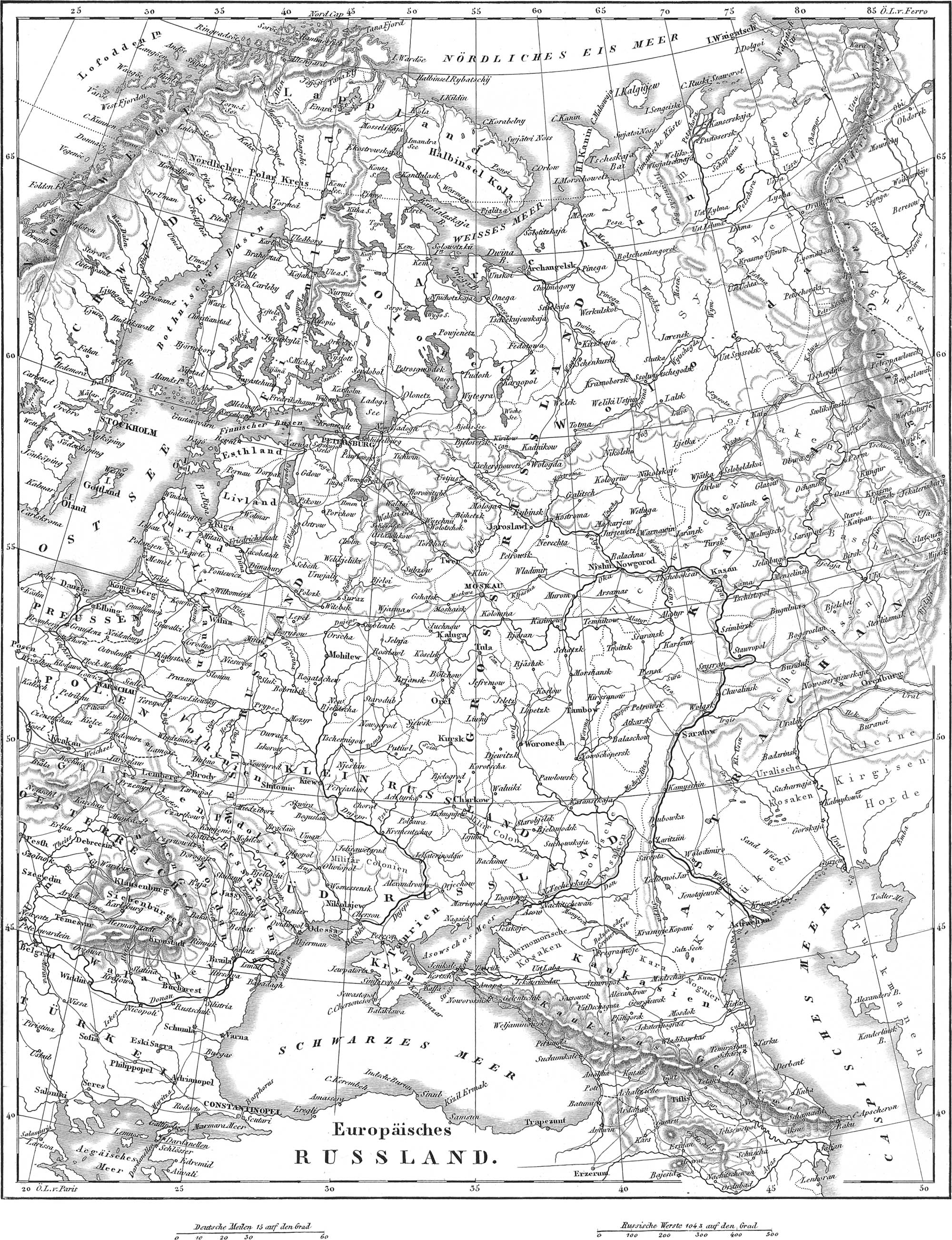
The Russian monarchy, in three continents, Europe, Asia, and America, is included between the meridians of 21° and 220° E. from Greenwich, equal in the latitude of the Arctic circle to 7590 statute miles, and between the parallels of 38° 40′ and 78° N. lat. This immense extent is divided by Behring’s Strait into two distinct portions, the eastern of which forms the north-west point of America. Of the larger, or European and Asiatic portion, the breadth varies from 1900 to 460 miles, giving an area of 3,409,000 square geographical miles, or 4,740,000 square statute miles: it is bounded on the north by Norway and the Arctic Ocean, on the east by the Pacific Ocean, on the south by the Chinese empire, Tartary, the Caspian Sea, Asiatic and European Turkey, the sea of Azof, the Black Sea, and Austria (Galicia), and on the west by Moldavia, Austria, Prussia, the Baltic, Sweden, and Norway.
By far the most important mountain range is that of the Ural, on the boundary between Europe and Asia. This is nearly 1400 miles long, and in Kamen Peak reaches a height of 5,397 feet. There are no mountains in the interior; nevertheless, the great Sarmatian plain is interrupted by two elevations, the Baltic Ural in the north, and the Carpathian Ural in the south, which begins even in Germany. A mountain range in the Crimea attains an elevation of over 5000 feet, in Tschatirdag. In South Russia are vast woodless steppes or plains, and in Lithuania extended marshes.
The waters of Russia are exceedingly numerous. The principal rivers are: of those emptying into the Arctic Ocean, the Petschora, the Mesen, the Northern Dwina, formed by the union of the Jug and the Suchona, and the Onega; into the Baltic empty, the Kymen, the Neva, the Narowa, the Pernau, the Dwina, the Niemen (called Memel after its entrance into Prussia), the Weichsel (belonging to Prussia in its lower part); into the Black Sea and Sea of Azof, the Danube, the Dniester, the Dnieper (with the Beresina, the Southern Bug, &c ), the Don, and the Kuban; into the Caspian Sea, the Wolga, the largest stream in Europe, and the Ural. Besides these, Russia possesses some important canals, which serve to unite the White and Caspian Seas, the Baltic and the Black Seas. There are also numerous lakes. The Ladoga is the largest not only in Russia, but in all Europe; smaller lakes are the Onega, Peipus, Bielos, Saima, Ilmen, &c. Finnland is especially rich in lakes; in the south there are numerous salt lakes, the most important of which is the Elton.
The climate of so immense a country would naturally be very various; the northern part belongs to the frigid zone, and is bound up in perpetual snow and ice; in the south are cultivated the subtropical fruits and the vine. As a general rule, the climate is more severe than in other parts of Europe of equal latitude; although in equal latitudes, the eastern portion is much more severe than the western.
The principal products are grain, hemp, flax, flaxseed, timber, iron, fish, and wild animals. Rye is more cultivated than the other cerealia, wheat being only raised in appreciable quantity in Poland, and rice and Indian corn in the south. In particular portions of the empire are produced wine, spices, medicinal plants, and tobacco. The forests of the north consist of pines and birches; those of the south of beech. The principal domestic animals are cattle, sheep, hogs, and horses; there are reindeer in the north, and camels in the south. The wild animals are bears, wolves, sables, beavers, martins, weasels, foxes, badgers, wild cats, lynxes, otters, squirrels, and in the south, antelopes. Besides those of iron, there are valuable mines of copper, platinum, lead, and (in the Ural) gold. Large quantities of rock salt are also mined.
The sum total of the population amounts, in all probability, to about sixty-six millions, of which sixty millions belong to the European portion, including Poland and Finnland. Excepting about one million of Mongolians (Baschkirs, Kirgises, Calmucks, Tartars, Samoiedes), the entire European population belongs to the Caucasian race, which is here reducible to the following stocks: 1, the Slavonic, constituting the great majority, and divided into the Russians, Poles, Letts, Lithuanians, Serbians, Bulgarians, Wallachians, and Moldavians; 2, Tschudic, about three to four millions, divided into Finns, Lapps, Esthonians, Livonians, Permians, Tscheremissians, Tschuwaschians, &c.; 3, Germanic, about half a million; 4, Jewish, about one million and a half; 5, Greek, about half a million. The general ratio of population is very small, not much over ten to the square mile, and even in the European portion scarcely thirty-five.
The established religion of Russia is the Greek Catholic Church. Next to this, the Roman Catholic (to which most of the Poles belong) has the greatest number of adherents. There are, in addition, over two millions and a half of Protestants, one million and a half of Jews, and one million and three quarters of Mahommedans, thirty thousand Lamaites, &c. The intellectual culture of the people is greatly in arrear, although much has been done within the last century. At the head of the seminaries of learning stand seven universities: those of St. Petersburg, Moscow, Dorpat, Helsingfors, Charkow, Kiew, and Kasan. These exercise a general supervision over all schools of lower grade. The inhabitants of the arable regions carry on a lively trade in the products of their farms, and the arts and manufactures exhibit a steady progression in excellence and extent. The most important articles of trade are candles, tallow, soap, leather, furs, sail cloth, linen, silks, potash, glass, powder, sugar, wooden ware, ropes, twine, &c. The inhabitants of the extreme north fish and hunt exclusively, while those of the Steppes raise cattle.
The form of government is an absolute monarchy. The head of the state (Emperor, now Nicholas L, born 1796, of the House of Holstein-Gottorp) must profess the religion of the Greek Church. No accurate idea can be formed of the revenues and expenditures of Russia, as nothing official is published on the subject. The European land force, with the reserve, is stated to amount to 568,000 men, with 97,640 horses, and 1672 pieces of artillery; to this must be added the Caucasian army, the Finnish, the Orenburg, and Siberian corps, together with various corps of Cossacks. The navy is estimated at fifty-six ships of the line and forty-eight frigates, without the steamboats and smaller vessels.
Political division. The Russian Empire is divided into governments, of which forty-nine belong to European Russia in its most restricted sense, eight to Finnland, and five to Poland. In addition to these, we shall present the historical division.
- Great Russia contains nineteen governments: Moscow (with the old capital Moscow, pop. 360,000), Woronesch, Kursk, Tambow, Rjasan, Tula, Orel, Kaluga, Smolensk, Pskow or Pleskow, Novogorod, Kostroma, Twer, Wladimir, Nischnei-Novogorod, Jaroslaw, Wologda, Olonetz, Archangel.
- Little Russia, whose eastern portion was formerly called the Ukraine, contains four governments: Kiew, Tschernigow, Pultawa, and Charkow (the Slobodian Ukraine).
- The Baltic Provinces consist of four governments: Ingermanland or St. Petersburg (with the capital and royal residence St. Petersburg, pop. 450,000), Esthonia, Livonia, and Courland.
- The Kingdom of Kasan consists of five governments: Kasan, Simbirsk, Pensa, Wjatka, and Perm.
- The Kingdom of Astrachan consists of four governments: Astrachan, Orenburg, Saratow, and Stawropol (Caucasus).
- South Russia, the most southern part, contains five governments: the land of the Don Cossacks, Jekaterinoslaw, Tauria, Chersonesus, and Bessarabia.
- West Russia, the south-western part, includes the governments of Witebsk, Mohilew, Podolia, Volhynia, Minsk, Grodno, Wilna, and Bialystok. Of these provinces, Pultawa has the largest population, and Astrakan the smallest; while on the other hand. Archangel is of greatest extent, and Bialystok of least.
Other lands belonging to the European portion of Russia are:
- The Grand Principality or Viceroyality of Finnland, containing 1,400,000 inhabitants, divided into eight governments: Nyland, Abo, Tawassehuus, Wiborg, St. Michael, Kuopio, Wasa, and Uleaborg.
- The Kingdom of Poland, with a population of 4,857,000, of which, in 1845, 3,800,000 were Roman Catholics, 550,000 Jews, 250,000 Lutherans, 240,000 United Greeks, 4200 Independent Greeks, 3800 Reformed, 3800 Greek Sectarians, 1250 Mennonites, 550 Moravian Brethren, 350 Zigeuni, and 300 Mohammedans. With the capital Warsaw (pop. 165,000) Poland is divided into five governments: Warsaw, Radom, Lublin, Augustowo, and Plock.
Russia in Asia embraces: 1. Siberia, with three millions of inhabitants, divided into the general governments of West Siberia and East Siberia, of which again the former is divided into the governments of Tobolsk, Omsk, and Tomsk; the latter into those of Jeniseisk, Irkutsk, lakutsk, Ochotsk, and the district of Kamtschatka. 2. Caucasus, consisting of the government of Grusia-Imereti, and the province of Caspia, or the former province of Georgia (or Grusia), Imiretia, Armenia, Tscherkessia, Schwirwan, and Daghestan. In a great part of these provinces, the Russian government is entirely repudiated.
Russia in America contains a population of probably sixty thousand souls.
Turkey
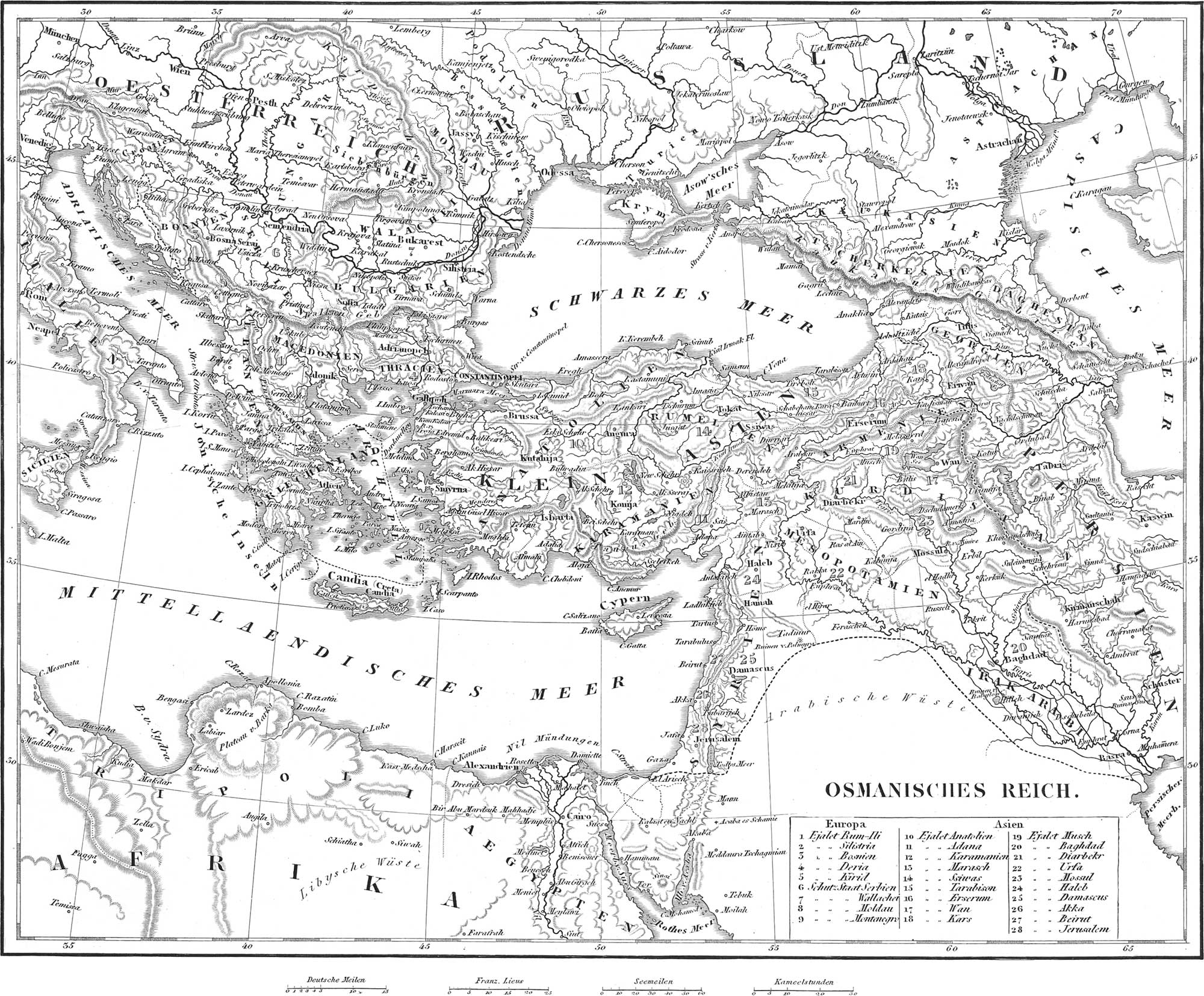
The Turkish or Ottoman Empire is included between the parallels of 31° and 49° north latitude, and is divided into European and Asiatic Turkey; the former, with an area of about 144,000 square geographical miles, and a population of thirteen millions, the latter with an area of 336,000 square geographical miles, and population of ten millions. Turkey in Europe, a part of the peninsula of Greece, is bounded on the north by Austria and Russia, on the west by Austria, the Adriatic and Ionian seas, on the south by Greece, and on the east by the Archipelago, the Sea of Marmora, and the Black Sea.
A considerable mountain divides the land into two tolerably equal parts, of which the northern includes Northern Bosnia, Servia, Bulgaria, Wallachia, and Moldavia; the southern, Rumelia, Macedonia, Albania, and Thessaly. It bears various names: in the west, where it is parallel to the Adriatic, it is called the Dinarian Alps, then Zamora, Argentara, Perserin, Schardagh, &c. At about the middle of the peninsula, the principal arm, termed Egrisu, divides into two branches, the more northern of which is called the Balkan, and afterwards Eminehdagh, the southern, Despoto Mountain. Towards the south are sent off from Schardagh, the Hellenic Mountains, called Voradagh in the north, and Mezzovo or Pindus in the south. From this pass off, towards the west, the Chimaero or Akrokeraunian Mountains; towards the east, the Volutza Mountains; and towards the north, the Livadian Mountains.
The only river of any importance in Turkey is the Danube. Into it empty from the west, or north, on Turkish territory, the Schyl or Schyll, the Aluta, the Dumbowitza with the Ardsisch, the Jalonitza, the Sereth with the Bystritza, and the Pruth, the latter the boundary to Russia; to the right, or from the south, the Sau or Save, the Morawa, the Isker, the Wid, and the Jandra. Much smaller rivers, and indeed only coast streams, are Maritza, Karasu or Nestus, Karasu or Strymon, Vardar, Indje-Karasu, Salambria, which empty into the Archipelago, also the Narenta, the Drin, the Yojussa, and the Aspropotamo, emptying into the Adriatic. The inland lakes are of no importance.
The climate of Turkey, north of the main range of mountains, is very similar to that of Germany; that to the south resembles that of Italy: it is everywhere healthy. The fertility of the country is extraordinary: of the vegetable kingdom, we find grain (in abundance), Indian corn, millet, wine, southern fruits, oil, cotton, flax, hemp, tobacco, wood of all kinds. To the animal kingdom belong beautiful horses, camels, asses, mules, horned cattle, hogs, bees, and wild beasts of various kinds. The mineral products are rock and sea salt, saltpetre, sulphur, and various metals, although the system of mining is very rude.
The population of Turkey in Europe is composed of Turks (about 700,000), Greeks (1,200,000), and Slavonians (principally in the north, Serbians, Bulgarians, Croats, Montenegrians: in all, about six millions); there are also about two millions of Wallachians and Moldavians (remains of the original population), 1,600,000 Albanians or Arnauts, 250,000 Jews, 100,000 Armenians, and 250,000 Zigeuni. The religion of the land is the Mohammedan, although there are about eight millions and a half of Christians, mostly Roman and Greek Catholics. The scientific culture of the Turks is very slight. Their principal occupation consists in agriculture and raising of cattle. The arts and manufactures are mainly conducted by Christians and Jews, and the very important foreign commerce is shared by these with the Armenians.
The government of Turkey is a despotism, the supreme ruler (now Abdul Meschid, born 1822) bearing the title of Padishaw, Pasha, Grand Sultan, Grand Turk, or Emperor. The minister of the Padishaw, to whom is delegated the supreme power, is called Grand Vizier; next to him, the Divan, composed of the principal state officers, exercises a great influence. Nothing definite is known as to the finances or military forces of Turkey.
Divisions. Politically, European Turkey is divided into Turkey proper and secondary Turkey. The former, besides the two capitals of Constantinople and Adrianople, is divided into five eyalets or provinces (each under a pasha of three tails), which again are subdivided into thirty-three sandschaks (under pashas of two tails). These eyalets are: 1, Rum-Ili, and 2, Silistria, which include the old provinces of Bulgaria, Thessaly, Thrace and Romania, Macedonia and Albania; 3, Bosna or Bosnia; 4, Deria, also called Dschesair or the viceroyalty of the Capudan Pasha, embraces the Turkish Islands of the Egsean Sea, except Crete, Taso, Samothraki, Imbro, Stalimene, (fee, as also the neighboring coast country; 5, Kirid, formed by the island of Crete, with a few neighboring islands.
Turkey secondary, or the vassal states, are: 6, Principality of Serbia, pop. one million, under Prince Alexander Georgewitsch (cap. Belgrade).
7. Principality of Wallachia, pop. 950,000, since 1849 under the Prince or Hospodar Barbo Stirbey (cap. Bucharest).
8. Principahty of Moldavia, pop. 450,000, under Hospodar Gregorius Alexander Ghika (cap. Jassy), also
9. The territory of Montenegro, on the borders of Dalmatia, the inhabitants of which, under their Vladika the Bishop of Cettigne, are almost entirely independent of the Porte.
Turkey in Asia is divided into nineteen eyalets, indicated on the map. Of these numbers, ten to fifteen constitute Asia Minor proper or Natolia; sixteen to nineteen, Armenia; twenty to twenty-three, Mesopotamia; and twenty-four to twenty-eight, Syria.
As to a Turkey in Africa, nothing more can be said than that the states of North Africa, to wit, Egypt, Tripoli, and Tunis (and excepting Fez, Morocco, and the French colony of Algiers), are little more than nominally subject and tributary to the Porte.
Greece

The kingdom of Hellas or Greece, containing about 14,000 square geographical miles, is included between the meridians of 18° 44′ and 25° 14′ longitude east of Greenwich, and the parallels of 36° 30′ and 30′ N. lat. It is bounded on the north by Turkey, in all other directions by the Mediterranean and Egaean seas. Northern Greece is traversed by the Hellenic Mountains, already referred to under the head of Turkey, and attaining, in Guiona, a height of 8538 feet, in Parnassus, 8068 feet. Other lofty summits are Oeta and Helicon. Even the Peloponnesus is very mountainous; the highest peak being Taygetos (7904 feet), and Zyria or Cyllene. The only rivers are the Aspropotamo (otherwise the Achelous), Evenus, Cephissus, Rusia or Ryzo (Alpheus), and Yri or Wasiliko (Eurotas). The climate of the valleys is very mild, but many of the mountain peaks are covered with snow for several months in the year. The chief products are oil, cotton, dried currants, tobacco, wine, madder, honey, and silk.
The inhabitants (850,000) are chiefly modern Greeks (a mixture of descendants of the ancient Greeks, and of Albanians, Wallachians, Slavonians, &c.); a portion consists also of Jews, Albanese, &c. The Greek Catholic is the prevailing religion; but on the islands there are some 20–30,000 Roman Catholics. Agriculture and manufactures are experiencing a progressive elevation in point of rank; and from the favorable position of the country, commerce has long been in a flourishing condition. The university of Greece, at Athens, stands at the head of the schools of public instruction, which have greatly increased since the erection of the state of Greece.
Until 1821, Greece was subject to Turkey, but having battled successfully for independence, it was recognised as free in 1829. Since 1832, it has formed a kingdom, governed by Prince Otto of Bavaria (brother of the present king of Bavaria), born 1815. In consequence of a revolutionary movement in September, 1843, a constitution was granted on the 16th March, 1844. The revenues of the state amount to about 2,400,000 dollars. The army includes 8900 men; the present navy, only two corvettes, two steamboats, three brigs, five cutters, and twelve gunboats.
Since 1838, Greece has been divided into twenty-four dioceses or governments; its natural divisions are:
- Northern Greece or Livadia, with the seven dioceses: Attica (with Megaris and iEgina, cap. Athens, with 26,000 inhabitants), Boeotia, Phthiotis, Phocis, Eurytania, iEtolia, and Acarnania.
- The Peninsula of Peloponnesus, or the Morea, with twelve dioceses: Argolis (with the island Spezzia and Hermione), Hydra (island), Corinth, Achaia, Cynoethe, Triphylia, Messenia, Mantinea, Gortynia, Lacedeemon, Laconia (cap. Maina).
- The Islands, with the five dioceses: Euboea (largest island of Greece, 1120 square geographical miles, with the islands Skiathos, Scopelcs, &c.), Tinos (with Andros), Syra (with the islands Keos, Cythnos, Milos, Syphnos, Cimolos, Pholegandros, Sicinos), Naxos (with Paros), and Thera (with the islands Amorgos, los, and Anaphe).
The seven Ionian Islands, situated to the west and south of Greece and Turkey: Corfu, Paxo, Santa Maura, Cephalonia (largest of all), Theaki, Zante, and Cerigo, with a population of 220,000, and with several smaller islands, constitute a republic under the protection of England. Accordirg to the constitution of 2d May, 1817, the executive power is in the hands of a senate of six members, the president of which is nominated by the king of England. The legislative assemblage embraces forty members, of whom eleven are chosen by the English Lord High Commissioner.
Italy
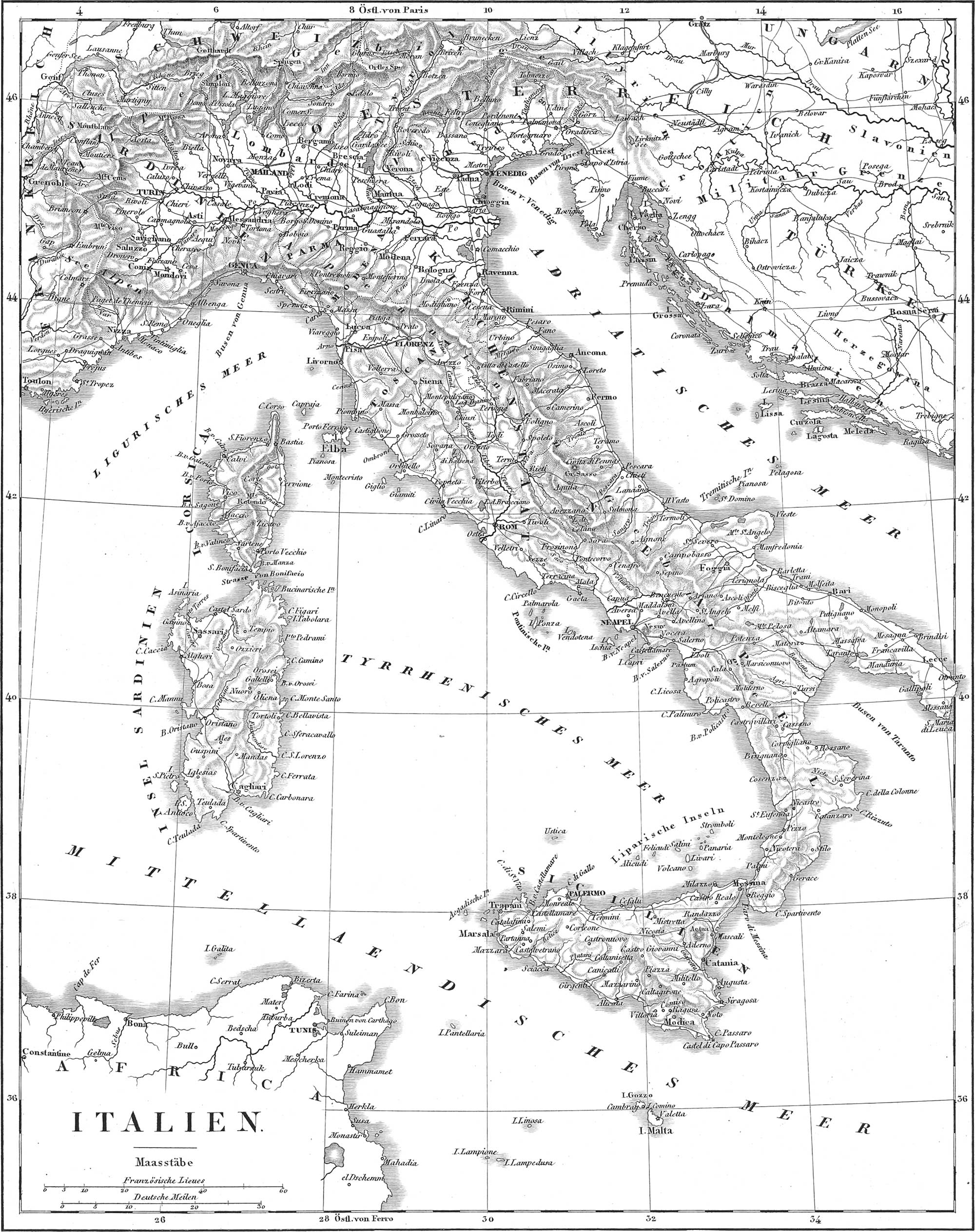
Italy, or the Apennine peninsula, with its islands, lies between the meridians of 5° and 18° 30′ east longitude from Greenwich, and the parallels of 36° and 46° 30′ N. lat., embracing about 120,000 square miles (excluding Corsica, which belongs to France). It is bounded on the north by Switzerland and the Tyrol, on the east by Austria (Illyria) and the Adriatic and Ionian seas, south and west by the Mediterranean and Tyrrhenian seas, and north-west by France.
Two great ranges of mountains belong either wholly or in part to Italy: the Alps and the Apennines. The Alps traverse the northern parts, and send the following chains into Italy: 1, the Sea or Maritime Alps, on the Gulf of Genoa (Monte Viso, 13,599 feet high), north of which are: 2, the Cottian Alps (Mont-Cenis, 6,772); 3, the Gray or Graian Alps (Mont-Iseran, 13,279); 4, the Pennine Alps (Monte Rosa, 15,210); 5, the Lepontine Alps, which only touch Italy in part. Between the Alps and the Apennines lies a hilly region. The Apennines, at whose northern slope the peninsula proper commences, join on to the Maritime Alps at the Col di Tenda, pass through Italy, first in an easterly direction, then south-east from lat. 44° to 41°, in a main range, whose greatest central elevation is in Mont Sasso (9521 feet), and finally re-appear in Sicily across the Straits of Messina. The local divisions of the Apennines are into Ligurian, Etrurian, Roman, Neapolitan, and Calabrian; the Abruzzi in Lower Italy constitute the highest and roughest. Mount Vesuvius near Naples, and Mount Etna in Sicily (10,874 feet), constitute isolated volcanic peaks.
The principal rivers of Italy are: 1. The Po, which rises in Monte-Yiso, flows through the whole of Upper Italy in an easterly direction, and empties into the Adriatic Sea by seven arms, after receiving the Dora Balta, the Sesia, the Tessin, the Adda, the Oglio, and the Mincio, on the left; and the Tanaro, the Trebbia, the Taro, and the Panaro, on the right. 2. The Adige, which comes from Germany and empties into the Adriatic not far from the Po, to which it is connected by branches. 3. The Arno, in Tuscany, empties into the Tyrrhenian Sea not far from Pisa. 4. The Tiber, united to the Arno by the channel of Chiana, empties by two arms into the Tyrrhenian Sea near Ostia. The coast rivers of Upper Italy are: Brenta, Piave, Tagliamento; of Lower Italy, Garigliano, Volturno, Pescara, Osanto, &c. The only Italian lakes of importance are in Upper Italy on the southern slope of the Alps; they consist of Lakes Maggiore, Como, and Garda, with the Tessin, the Adda, and the Mincio, flowing through them respectively. Only the second of the above-mentioned lakes belongs entirely to Italy; the two others lie with their northern extremities, the one in Switzerland, and the other in the Tyrol. In the valleys of many rivers, especially on the coast, there are considerable tracts of marsh land; among them are the Maremma of the Delta of the Po, those in Tuscany, and the Pontine marshes in the southern part of the Papal states.
The climate of Italy is very various. In the south may be seen the palm and sugar cane, in the north the thermometer sinks sometimes to 15° F. The climate of Sicily and of southern Naples bears much resemblance to that of Africa, and the Sirocco or south wind is exceedingly oppressive. In many parts of the country, noxious exhalations rise from the ground.
The chief products of Italy are: 1. From the mineral kingdom, iron (especially from Elba), mercury, alabaster, marble, stone coal and lignite, salt, saltpetre, brimstone (Sicily), alum, sal-ammoniac, tripoli, pumice, and various mineral pigments. From the vegetable kingdom: grain (especially wheat and Indian corn), rice, oil, wine, southern fruits, carob beans, sugar-cane, chestnuts, flax, hemp, tobacco, liquorice, and cork. From the animal kingdom: horses (especially in Naples), cattle, sheep, asses, mules, buffalo, goats, silkworms, bees, fish, oysters, &c. In the Alps are chamois, marmots, wolves, and bears.
The population of Italy amounts, perhaps, to twenty-four millions. Lucca is most densely, and Sardinia most thinly inhabited. The Italians are a mixed race, speaking a language with numerous dialects closely allied to the Latin; there are Hkewise French, Celtish, and German dialects in the north, and Greek in the south. The prevailing religion is the Roman Catholic, although there are about 36,000 Jews on the peninsula, and in Sardinia from 23,000 to 24,000 Waldenses. Popular education, excepting in the Lombardo- Venetian and Tuscan kingdoms, is in rather a low state. The culture of grain and the olive is most successful in the north, where also the silkworm and the products of mining are of importance. The manufactured products are silks, glass ware, mirrors, porcelain, soap, paper, gloves, essences, &c. Trade is extensively prosecuted, being greatly favored by the position of the country, but commerce is mostly in the hands of foreigners, and internal traffic thrives only in Upper Italy, where there are excellent roads and numerous canals.
Italy contains three kingdoms: the Lombardo-Venetian (under Austrian sway), Sardinia, and the two Sicilies; one Grand Duchy, Tuscany; the Papal States; two Duchies, Modena and Parma; one republic, San Marino; and finally two islands, Corsica and Malta, belonging respectively to France and England.
- The Lombardo-Venetian Kingdom (see Austria).
-
Kingdom of Sardinia. This state, with an area of 29,534 English square miles, contains 4,650,000 inhabitants (according to the census of 1839). The present king, Victor Emanuel II. (born 1820), of the House of Savoy-Carignan, has ruled since 1849, and according to the constitution of March 5th, 1848. According to this, the crown shares the lawgiving power with two chambers, a senate (the members chosen by the king), and an elective chamber. The land forces amount, on the peace establishment, to 37,500 men, and on the war, to 146,000; the navy, to four frigates, four steamboats, three brigantines, &c., in all seventy-seven vessels of war.
Divisions. The state is divided into the provinces of the mainland, with 4,125,000 inhabitants, and the island of Sardinia with 525,000. The former consist of the Principality of Piedmont, the Duchies of Savoy, Montserrat, and Genoa, a portion of Milan, and the county of Nice (Nizza); these are divided into eight circles, all of which, excepting Savoy, are named after their chief towns: 1, Turin, with the capital and royal residence, containing 125,000 inhabitants; 2, Cuneo or Coni, the southern part of Piedmont; 3, Savoy, with the capital Chambery; 4, Alessandria, and 5, Novara (the Sardinian portion of Milan); 6, Aosta, the northern part of Piedmont; 7, Nice; 8, Genoa, with the island of Capraia, not far from the coast of Tuscany.
The island of Sardinia (cap. Cagliari) is ruled by a vice-king, and is divided into the circles, Caghari, Sassari, and Nuoro.
- The Duchy of Parma. The Duchy of Parma is surrounded by Sardinia, Lombardy, Modena, and Tuscany, and has about 500,000 inhabitants, on an area of about 1760 square geographical miles. The present king, Charles III., of a Spanish branch of the House of Bourbon, has ruled since 1849. The country consists of the Duchies of Parma (cap, Parma, with 40,000 inhabitants) and Piacenza, to which were added, in 1848, the districts of Pontremoli, Bagnone, Villafranca, &c., derived partly from Modena, partly from Tuscany.
-
Duchy of Modena. This is surrounded by Lombardy, Parma, the Papal States, and by Tuscany, and possesses an area of 1672 square geographical miles, with a pop. of 500,000.
The present duke, Francis V., from a branch of the House of Austria, has reigned since 1846. The land consists of the four Duchies of Modena (with the capital and royal residence of the same name, pop. 27,000), Reggio, Guastalla (separated from Parma in 1848), and Massa.
- Grand Duchy of Tuscany. Tuscany is bounded on the north by Modena and the Papal States, east and south-east likewise by the Papal States, and on the west by the Tyrrhenian Sea. With an area of 6880 square geographical miles, it has a population of 1,800,000, The present grand duke, Leopold II. (born in 1797) of a branch of the House of Austria, has reigned since 1824. The government is a constitutional monarchy, according to the constitution of 15th February, 1848. The lawgiving power is shared by the prince with two chambers, of which the first consists of members chosen for life by the grand duke, the second of members elected by the people. The revenues of the state amount to twenty-five millions of lira or 3,875,000 dollars. The forces embrace 5500 men. According to the earlier arrangements, the land was divided into five compartimentos or circles, named after the chief towns: Florence (with the capital and royal residence, containing 102,000 inhabitants), Pisa (with the island Elba), Siena, Arezzo, and Grossetto: to these Lucca has been added since 1848, with 170,000 inhabitants.
- The Papal States. The Papal States, with an area of about 12,000 square geographical miles, contain three millions of inhabitants. The present pope, Pius IX., of the family of Mastai-Ferrenti, born in 1792, has reigned since 1846. The form of government was an absolute monarchy, up to 1848; then for a short time a constitutional monarchy, until the proclaiming of a Roman Republic, February 9th, 1849; since the downfall of which latter, it has again become an absolute monarchy. The revenues, before the breaking out of the Revolution, amounted to 9,600,000 scudi, or to the same number of American dollars. The papal army is at present entirely disbanded. Since 1831, the land has been divided into one comarca, Rome, with the capital and royal residence of the same name (170,000 inhabitants); six legations, named according to the principal towns: Bologna, Ferrara, Forli, Ravenna, Urbino (with Pesaro), and Velletri; and thirteen delegations, likewise named after the principal towns: Ancona, Macerata, Camerino, Fermo, Ascoli, Perugia, Spoleto, Rieti, Viterbo, Orvieto, Frosinone, Civita-Vecchia, and Benevento.
- The Republic of San-Marino. This small republic lies within the boundaries of the Papal States. It possesses a population of about 7600, on an area of about twenty square miles. The chief town contains 5500 inhabitants. At the head of the state stand two capitani regenti, elected for six months.
-
The Kingdom of the Two Sicilies. This constitutes the southern part of Italy, and contains 8,423,060 inhabitants to an area of about 43,052 English square miles. The present king, Frederick II., born 1810, of the Spanish line of the House of Bourbon, has ruled since 1830. The form of government is a constitutional monarchy. According to the constitution of February 10th, 1848, the king shares the law-giving power with two chambers, one of peers (chosen by the king in unlimited number for life), and a chamber of deputies, one to every 40,000 of the population. The relation of Sicily to the state is not yet definitively established.
The army, before the outbreak in Sicily, consisted of about 49,000 men, without the reserve forces; the navy, of one ship of the line and five frigates, one corvette, five brigantines, two galliots, and fourteen steamboats.
The state is geographically divisible into two principal parts.
- Sicily this side of the straits, also called Naples, with 6,383,000 inhabitants, is divided into fifteen intendancies. Of these, the old province of Terra di Lavoro was constituted by Naples (with the city Naples, pop. 400,000, and the islands of Capri, Ischia, and Procida), Terra di Lavoro, Principato citeriore, and Principato ulteriore; Abruzzo ulteriore I., A. ulteriore II., and A. citeriore, form the old province Abruzzo; Capitanata, Molise, Terra di Bari, Terra di Otranto, constitute the ancient Apulia; and finally Basilicata, Calabria citeriore, and Calabria ulteriore I. and II., the ancient Calabria.
- The kingdom of Sicily beyond the straits, consists of the island of Sicily, also of the Lipari and iEgidian Islands: it contains about 2,040,000 inhabitants, and is divided into the following intendancies: Palermo (with the capital of same name, pop. 170,000), Girgenti, Trapani, Caltanisette, Messina, Syracuse, and Catania.
- The Islands of Malta, Gozzo, and Comino, contain about eighty square geographical miles, and 124,000 inhabitants. The capital, La Valetta, with 60,000 inhabitants, is situated on the island of Malta.
The Austrian Monarchy
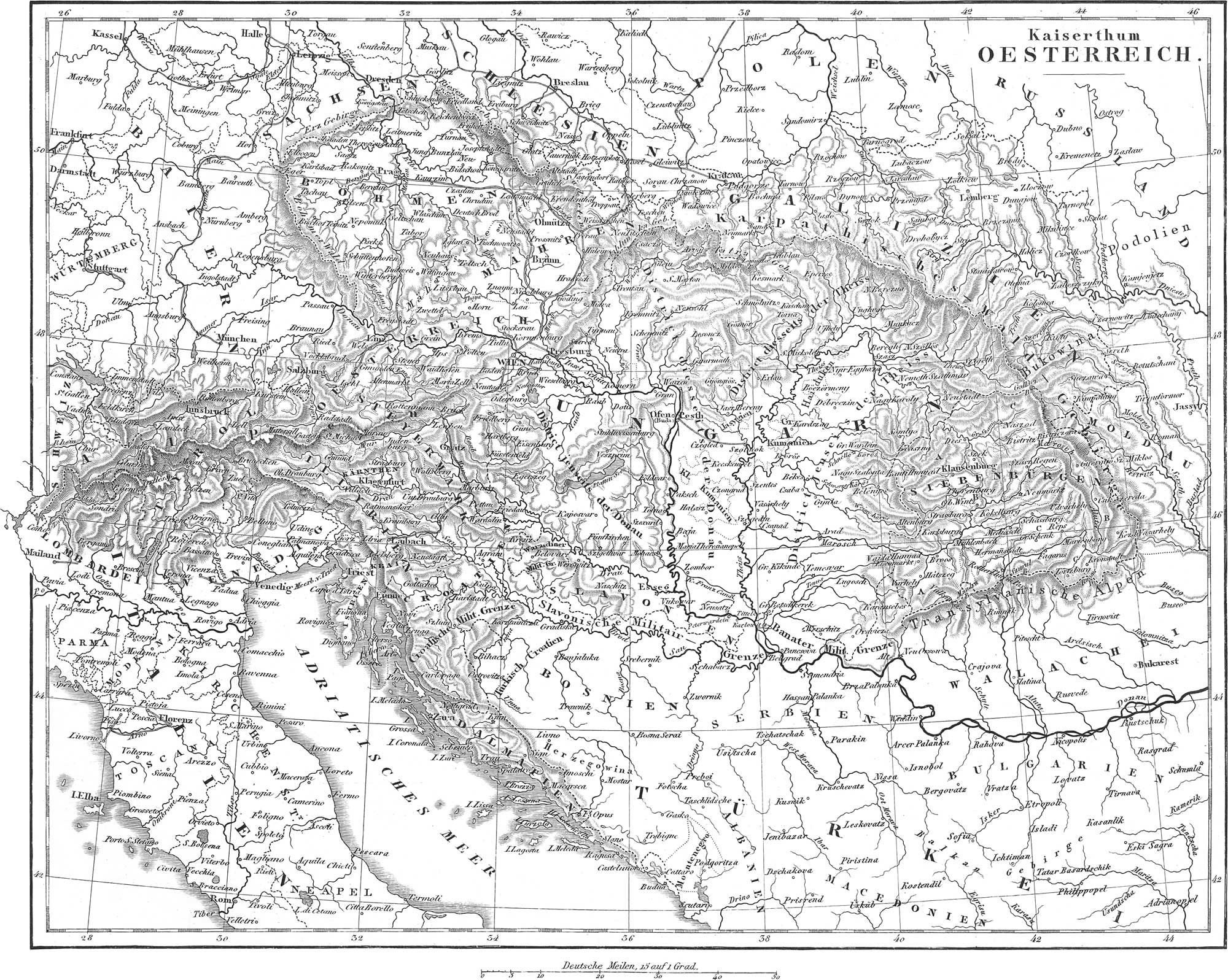
The Empire of Austria is situated between the meridians of 8° 29′ and 26° 29′ longitude east of Greenwich, and between the parallels of 42° 15′ and 51° N. lat. It is bounded on the south and east by Turkey, on the north-east and north by Russia, to the north and west by Prussia, Saxony, Bavaria, and Switzerland, and to the south and west by Sardinia, Parma, Modena, the Papal States, and the Adriatic Sea. Its area amounts to about 193,000 square geographical miles.
The principal mountains of Austria are the Alps and the Carpathians. The Alps divide into the following chains: 1. The eastern Rhaetian Alps, with one main and two secondary chains (highest point Ortlerspitz, 12,851 feet). 2. The Norian Alps, consisting of three main chains (here belong the Styrian, Austrian, and east Salzburgian Alps; highest point Grossglockner). 3. The Carniac or Carinthian Alps, attaining a height of eight to nine thousand feet. 4. The Julian or Krainian Alps, the Terglou, 9386 feet. The Carpathians divide into six main groups: 1. The Central Carpathians or the Krapack Mountains, attaining a height of 8611 feet in Lomnitzer Spitze. 2. The Beskides and Babia Goru. 3. The Lesser or Hungarian Carpathians. 4. The Hungarian Erzgebirge (over 6200 feet high). 5. The Carpathian Waldgebirge. 6. The Siebenbürgian Carpathians, over 9500 feet high. The space between the Alps and Carpathians is filled by the Hungarian plains, of which that of Lower Hungary covers an area of over 24,000 square geographical miles.
Pre-eminent among the rivers of Austria stands the Danube, with its numerous tributaries. Those of the right bank are the Inn, with the Salzach, Traun, Ens, Leitha, Raab, Drau, Sau. To the left are the March or Morawa, Waag, Neutra, Gran, Eypel, Theiss (largest tributary of the Danube). The Weichsel forms the north-western boundary of Galicia.
The principal productions of Austria, which is more highly endowed by nature than any other country in Europe, are from the mineral kingdom: gold, silver, copper, lead, tin, iron, mercury, cinnabar, cobalt, calamine, arsenic, zinc, precious stones, marble, alabaster, gypsum, sulphur, peat, lignite, stone coal, salt, soda, vitriol, alum, saltpetre, and mineral waters. From the vegetable kingdom are derived, grain, Indian corn, rice, garden and kitchen vegetables, fruits, timber, wine, tobacco, hops, flax, hemp, saffron, madder, safflower, liquorice wood, mastich, and succory or chicory. The animals are horses, cattle, buffaloes, sheep, hogs, goats, asses, bears, lynxes, wolves, marmots, chamois, tortoises, domestic fowls, pheasants, salt and freshwater fish, bees, silkworms, and leeches.
The population of Austria amounts to nearly thirty-eight millions; it is densest in the Italian provinces, and most sparse in the Tyro). The inhabitants belong to four principal stocks: to the German (about eight millions), the Slavic (over fifteen millions), the Hungarian (five millions and a half), and the Graeco-Latin (over eight millions). The Slavi are divisible into the Tschechs, Moravians, Slowaks, Poles, Ruthenes, Slowenes, Croats, Slavonians, Serbians, Dalmatians, and Istrians. To the Hungarians or Magyars belong the Szekls in Siebenbürgen; to the Graeco-Latin stock, the Italians, Wallachians, Moldavians, and Greeks. To the above-mentioned stocks must be added about 700,000 Jews (mostly in Galicia and Hungary), 93,000 Zigeuni, Armenians, &c. The prevailing religion is the Roman Catholic; there are, however, about three millions of independent Greeks, over two millions Reformed, 1,200,000 Lutherans, 50,000 Socinians, 17,000 Arminians, 700,000 Jews, &c. At the head of numerous establishments of learning stand nine universities; those of Vienna, Prague, Innsbruck, Gratz, Olmiitz, Pesth, Lemberg, Padua, and Pavia; also the Academy of Sciences in Vienna, founded in 1846. The principal manufactured products are linens, sail cloths, point lace, cotton and silk goods, cloths, shawls, carpets, hats, paper, leather ware, tobacco, sugar, soap, wax, fabrications of gold and silver, chemical apparatus, iron, glass, mirrors, &c.
The form of government, up to March, 1848, was an absolute monarchy; since that, it has been changed to the constitutional form. According to the chartered constitution of March 4th, 1849, which is to avail for the whole empire, the emperor (since 1849, Francis Joseph, born 1830) shares the lawgiving power with two houses, an upper and a lower house. In addition to this, each crown land has a special constitution and a special diet. The revenues of the state (Hungary excepted) amounted, in 1847, to over 151 millions of gulden, or more than seventy-one millions of dollars. In the half year ending April, 1847, the receipts amounted to over forty-five millions of gulden, the expenditures to nearly ninety-one millions. The army, in 1847, consisted of 315,000 infantry, 49,000 cavalry on the peace establishment, and 489,000 infantry, and 65,000 cavalry on the war footing. In addition to these were 26,000 artillery, and various extra corps, the engineer corps, pioneer corps, &c. At present all the troops are divided into five army corps, of which the fifth embraces the military limits; the four others include 358 battalions, 281 squadrons, and 766 pieces of artillery. The navy consists of three frigates, two corvettes, five brigs, one steamer, two galliots, and eight gun-boats.
According to the new constitution, the whole state is divided into the following crown lands:
- German. I. Grand Duchy of Austria above the Ens, or Upper Austria, pop. 704,572, cap. Linz. 2. Archduchy of Austria below the Ens, or Lower Austria, with 1,417,783 inhabitants, cap. Vienna, at the same time capital of the whole empire, with 410,000 inhabitants. 3. Duchy of Salzburg, pop. 146,519, cap. Salzburg. 4. Duchy of Styria, pop. 999,681, divided into three circles, those of Gratz, Bruck, and Marburg, cap. Gratz. 5. Duchy of Carinthia, pop. 316,838. 6. Duchy of Crainia, pop. 474,525, cap. Laibach. 7. Coast lands with Friaul and the counties Gorz and Gradiska, pop. 500,000, cap. Triest. 8. Counties of Tyrol and Vorarlberg, pop. 867,178, divided into four circles, those of Innsbruck, Brixen, Trient, and Vorarlberg, cap. Innsbruck. 9. Kingdom of Bohemia, pop. 4,513,074, divided into seven circles; their capitals are Prague, Budweis, Prachatitz, Gitschin, Bohmisch-Leippa, Eger, and Pilsen. 10. Marcgravedom of Moravia, with 1,826,057 inhabitants, divided into the circles of Brünn and Olmütz, cap. Olmütz. 11. Duchy of Silesia, w4th 467,420 inhabitants.
- Extra German. 1. Kingdom of Galicia, with the Duchy of Cracow, pop. 5,250,000, cap. Lemberg. 2. Duchy of Bukowina, pop. 354,000, cap. Czernowitz. 3. Kingdom of Dalmatia, Croatia, and Slavonia, with the coast land of Croatia, pop. 1,300,000. 4. Kingdom of Hungary, pop. ten millions, cap. Ofen. 5. Grand Principality of Siebenbiirgen, pop. 2,182,000, cap. Klausenburg. 6. Lands of the military limits, pop. 1,226,000, divided into the Croatian, Hungarian, and Siebenbiirgian. 7. Lombardo- Venetian kingdom, pop. five millions, divided into the government of Lombardy (cap. Milan) and Venice, cap. Venice.
Prussia
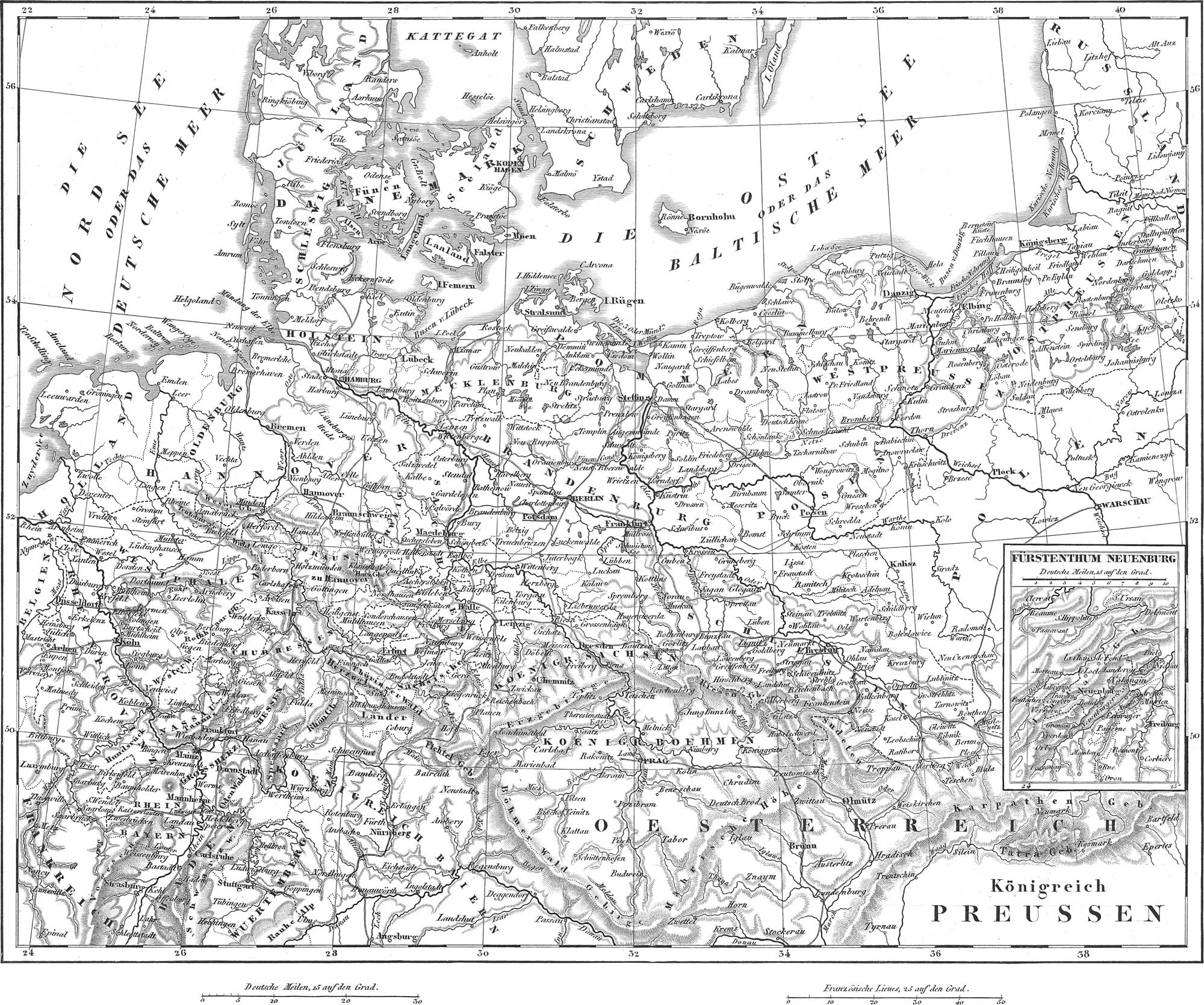
The state of Prussia is situated between the meridians of 5° 44′ and 22° 44′ of longitude east of Greenwich, and the parallels of 40° 8′ and 55° 52′ N. lat., and is divisible into a large eastern and a smaller western portion. The former is bounded on the east by Russia and Poland, south by Austria (Galicia, Moravia, Bohemia), Saxony, and the Duchy of Saxony, west by the Electorate of Hesse-Hanover, Brunswick and Mecklenburg, and north by the Baltic. The smaller portion is bounded to the N. E. and S. by various German states, Bavaria, Hesse-Darmstadt, Nassau, Waldeck, Hesse-Lippe, and Hanover, and west by France, Belgium, and the Netherlands. The area of the whole monarchy amounts to about 81,280 square geographical miles, of which a sixth belongs to the western part.
The mountains of Germany which belong under this head are: in the south-east, the Sudetes, the Glatzer- and Riesen-Gebirge (highest summit 5300), the Thuringerwald; in the western part, the Egge, the Westerwald, the Hundsrück, the Lippische Wald, the Sauerland Mountains, the Siebengebirge, the Hochwald, and the Eiffel. The principal streams are: 1. The Weichsel, which rising in Germany enters Galicia, returns again to Germany, and below Marienwerder divides into two arms, the most eastern of which, the Nogat, empties by twenty mouths into the Frische Haff, while the western, which retains the name of Weichsel, divides near the sea into the Old and Dantzig- Weichsel, and empties by fourteen mouths into the Frische Haff, and by two into the Gulf of Dantzig. 2. The Oder, which rises in Moravia at the foot of the Sudetes, passes into Silesia, and flows for over five hundred miles through Prussian territory. Its tributaries are, to the right, Olsa, Klodnitz, Bartsch, Warthe, Ihna; to the left, Neisse, Ohlau, Weistritz, Katzbach, Bober, Gorlitz, Neisse, and Ucker. 3. The Elbe, which rises on the southern slope of the Riesengebirge, and empties into the North Sea about eighty-five miles below Hamburg. Such of its tributaries as belong here, are: to the right, the Black Elster, and Havel with the Spree; to the left, Mulde and Saale. 4. The Weser merely touches the territory of Prussia, forming for a short distance the line of separation from Brunswick. 5. The Rhine, from Bingen to above Coblentz, forms the boundary to Nassau, and passes through the western part of the state to enter the Netherlands below Emmerich. Its Prussian tributaries are, to the right, Lahn, Sieg, Wupper, and Ruhr; to the left, Nahe, Moselle, and Erft.
The climate and productions of Prussia are not essentially different from those of Germany. In addition to the cereaHa, the culture of flax, tobacco, hops, fruit, and the vine, is of importance. Cattle are not raised in large quantities, but the rearing of sheep is attended to more and more. Prussia is very rich in minerals, especially silver, copper, lead, iron, salt, sulphur, lignite, and stone coal.
The population amounted, at the end of 1846, to 16,112,948 souls. It is densest in the Rhine provinces, and sparsest in Pomerania. The predominant races are the German, Slavic (Poles, Wendes, Lithuanians, &c.), Walloons, and Jews. The inhabitants, in respect to their religious belief, may be divided into Evangelical (1846, 9,835,000), Roman Catholics (over six millions), 215,000 Jews, 14,500 Mennonites, 1675 adherents to the Greek Church (Philippones). There are also Moravian Brethren, Hussites, Unitarians, and Herrnhuters. In intellectual culture, as well as in mechanical skill, the people take high rank. At the head of the seminaries of instruction, stand the universities of Berlin, Konigsberg, Halle, Greifswald (all protestant), those of Bonn and Breslau (mixed), and the Roman Catholic academy at Münster.
The Prussian form of government is a constitutional monarchy, ruled, since 1840, by King Frederick William IV. (born 1795), of the House of Hohenzollern. After the national convention called together in May 22, 1848, had been dissolved in December, 1848, without having agreed with the king upon a constitution, a chartered constitution was given to Prussia, with the proviso of a revision in the proper mode of legislation. According to this, the law-making power is exercised in common by two chambers, one consisting of 180, and the other of 350 members, all of them elected. According to official publications, the revenues for 1849 amounted to eighty-eight millions and a half of thalers (fifty-nine millions of dollars), and the state debt to 162,861,444 thalers (108,574,296 dollars). The standing army on the peace establishment amounts to 121,100 men, the Landwehr of the first summons to 96,100, that of the second to 62,600. The war footing amounts to 325,300 field troops, and 167,500 garrison soldiers (without counting the officers, commissioned and non-commissioned).
Prussia is divided into the following eight provinces: I. Prussia, consisting of: a, East Prussia, area 11,296 square geographical miles, pop. 1,480,000; circles, Konigsberg and Gumbinnen; b, West Prussia, 7552 square geographical miles, pop. 1,019,000: circles, Dantzig and Marienwerder. The capital of the province is Königsberg, with 75,000 inhabitants. II. Posen, 8576 square geographical miles, pop. 1,364,000; circles, Posen and Bromberg. The capital, Posen, has 40,000 inhabitants. III. Pomerania, area 9184 square geographical miles, and 1,165,000 inhabitants, including the largest island of Germany, Riigen (pop. 3700); circles, Stettin, Cöslin, and Stralsund. The capital is Stettin, with 41,500 inhabitants. IV. Silesia, area 11,872 square geographical miles, pop. 3,066,000; circles, Breslau, Oppeln, and Liegnitz, capital Breslau, with 112,000 inhabitants. V. Brandenburg, area 1 1,744 square geographical miles, pop. 2,067,000; circles, Potsdam (with Berlin) and Frankfort. Berlin, with 300,000 inhabitants, is the capital of the province, and at the same time of the monarchy. VI. Saxony, Sirea 7376 square geographical miles, pop. 1,742,000; circles, Magdeburg, Merseburg, and Erfurt, capital Magdeburg, with 55,80C inhabitants. VII. Westphalia, 5588 square geographical miles, pop. 1,446,000; circles, Münster, Minden, and Arnsberg, capital Münster, with 23,000 inhabitants. VIII. Province of the Rhine, area 7792 square geographical miles, pop. 2,763,000; circles, Cologne, Düsseldorf, Coblentz, Trier, and Aix la Chapelle. The capital Cologne, with the suburbs, has 95,000 inhabitants.
Germany Double Plate 15, 16
Germany, including the Prussian provinces of Posen and Prussia, and the Austrian provinces hitherto reckoned with Germany, extends from 44° 50′ to 55° 50′ of N. lat., and from 5° 44′ to 22° 44′ of longitude east of Greenwich (23° 30′ to 40° 30′ east of Ferro). It is bounded on the north by the North Sea, Denmark (Schleswig), and the Baltic; east by Russia, Poland, Galicia, and Hungary; south by Croatia, the Adriatic Sea, Italy, and Switzerland; and west by France, Belgium, and the Netherlands. The area amounts to over 209,600 square geographical miles.
The Alps, the most important of the mountains of Germany, have already been considered under Austria, only a very small portion coming into Germany proper, or into Bavaria. North of the Alps, the plateau of South Germany expands itself to the Danube. The mountain districts of Middle Germany may be divided into a western, middle, and eastern portion. In the western, we find on the left bank of the Rhine, the Haardt (1800 to 2200 feet), the Donnersberg, the Hundsriick, the Eifelberg, and the high Veen, which borders on the Ardennes. In the middle part between the Rhine and the Elbe, are: a, between the Rhine, Danube, Naab, and Main: the Schwarzwald, the German and Franconian Jura, the Odenwald; b, between the Rhine, Main, Werra, and Weser: Taunus, Vogelsgebirge, the Spessart, the Rhone Mountain, the Westerwald, Siebengebirge, the Wesergebirge, the Egge, the Teutoburgerwald; c, between the Weser, Werra, Main, Naab, Danube, March, and Elbe: the Hartz, the Frankenwald, the Thüringerwald, the Fichtelgebirge, the Böhmerwald, the Saxon Erzgebirge, &c. In the eastern part, there are only the Sudetes, individual regions of which bear different names: the Meissner Highland or Saxon Switzerland, Lausatian Mountains, Isargebirge, Riesengebirge, Silesian Erzgebirge, Schweidnitz Mountains, &c. The northern part of Germany consists of the north German plateau.
The rivers may be divided into those of the northern and southern slopes. To the former belong the Rhine, Ems, Weser, Elbe, Oder, Weichsel, Pregel, and Memel (Niemen), together with several coast streams, as the Vechte, Trave, Warnow, Recknitz, Peine, &c. To the southern slope belong the Danube and the Etsch. Lakes of some size occur only in south Germany; thus, besides the Boden-see we here find Lakes Chiem, Ammer, Tegern, König, Traun, &c.
The climate of Germany, on the whole, is mild, although severe in the Alpine districts. The climate of the north is generally moister and more variable than that of the south; in the east, the extremes of temperature are greater than in the west. In the valleys of South Tyrol, and on the coast land along the Adriatic, the climate is much like that of northern Italy.
The products are, on the whole, much the same with those already given under the heads of Prussia and Austria. From the mineral kingdom are derived, iron, lead, silver, copper, zinc, tin, mercury, cinnabar, &c.; from the vegetable, Indian corn, grain in general, chestnuts, almonds, &c.; from the animal, most European species of mammalia and birds, and of fishes, sturgeon, salmon, trout, eels, pike, &c.
The population of Germany, with the provinces recently added, amounts to forty-five millions; densest in the kingdom of Saxony, and sparsest in Pomerania and Mecklenburg-Strelitz. This, besides the Germans proper, consists of seven to eight millions of Slavi, numerous Lithuanians in the province of Prussia, 400,000 Italians (in lllyria and the Tyrol), 300,000 Walloons, about 400,000 Jews, 500 Greeks and Armenians, and 500 Zigeuni. In a denominational point of view, there are over twenty-two millions of Roman Catholics, twenty-one millions of Lutherans and Reformed, 35,000 Herrnhuters and other sects, with 400,000 Jews. The arts and sciences have attained to a high degree of advancement among the inhabitants of Germany; and the state of education is in a highly prosperous condition. Of the twenty-five universities, six are in Prussia, five in Austria, three in Bavaria, two in Baden, one to each in Würtemberg, Hanover, Saxony, Saxe- Weimar, Mecklenburg-Schwerin, Hesse-Darmstadt, Electoral Hesse, and Holstein. There are also several hundred Gymnasia (Colleges), and about one hundred large public libraries. All branches of agriculture, forest culture, cattle breeding, &c., are prosperous. Foreign commerce is carried on mainly from the towns of Hamburg, Triest, Bremen, Stettin, Lübeck, Emden, Kiel, Dantzig, Berlin, Frankfurt on the Main, Leipzig, Nürnberg, Augsburg, and Vienna. The German Zollverein or Customs Union, has greatly contributed to the flourishing state of trade: this embraces all the states excepting Austria, Hanover, Oldenburg, Schaumburg-Lippe, the two Mecklenburgs, Holstein, the three Hanse towns, and Lichtenstein.
The political relations of Germany are very undecided. The commonwealth consists of thirty-eight larger and smaller states, which, after the dissolution of the German Empire in 1806, were held together by the German Alliance (established by the act of June 9th, 1815). This faulty political creation fell to the ground soon after the meeting of the German Constitutional Convention at Frankfurt on the Main, May 18th, 1848 (June 12, 1848): this established a provisional central government, and at the head of affairs was established Archduke John of Austria as regent. The convention above referred to, fixed upon a plan, according to which the king of Prussia was to come in as the head of affairs; but it separated in May of the same year, without having had the plan recognised and carried out. By a compact concluded on the 30th September, 1849, at Vienna, between Austria and Prussia, a new provisional central government has been established, to be managed by these two powers in common, and to consist of two members from each state: nevertheless, this little promising plan still lacks the assent of a portion of the remaining states. In fact, the regent, on the 6th October, 1849, announced his return to the exercise of his former office in Austria.
The individual states of Germany, omitting those already mentioned under the heads of Austria and Prussia, are as follows:
- Kingdom of Bavaria, with 22,304 square geographical miles, pop. 4,504,874. Maximilian 11. (born 1811), king since 1848. Annual revenues about thirty-two millions of gulden (over twelve millions of dollars). Army, 76,294 men. Divided into six circles: Upper Bavaria, cap. Munich, with 113,000 inhabitants; Lower Bavaria, cap. Passau; Palatinate, cap. Speier; Upper Palatinate and Regensburg, cap. Regensburg (Ratisbon); Upper Franconia, cap. Baireuth; Middle Franconia, cap. Ansbach; Lower Franconia and Aschaifenburg, cap. Würzburg.
- Kingdom of Saxony, area 4352 square geographical miles, pop. 1,836,433. Frederick Augustus II., king since 1836. Constitution of September 4, 1831. Annual revenues, 4,200,000 dollars (American). Army formerly of 16,355 men: at present it is to consist of two per cent, of the population. Divided into five circles: Meissen (cap. Dresden, pop. 89,000), Leipzig (cap. Leipzig, pop. 60,000), Erzgebirge (cap. Freiberg, pop. 12,000), Voigtland (cap. Plauen. pop. 10,000), and Lausitz (cap. Bautzen, pop. 8000).
- Kingdom of Würtemberg, area 5760 square geographical miles, pop. 1,743,827. William I. (born 1781), king since 1816. Constitution dates from 25th Sept., 1819, but is shortly to be revised. Revenues, sixteen millions and a half of gulden (nearly $7,000,000). Army 19,000 (war footing). Divided into four circles: circles of the Neckar (cap. Stuttgardt, pop. 47,000); Schwartzwald (cap. Reutlingen); Jaxt (cap. Reutlingen); and Danube (cap. Ulm).
- Kingdom of Hanover, area 11,184 square geographical miles, pop. 1,758,847; revenues, five millions of dollars. Army of 21,200 men. The constitutional law of 6th August, 1848, has been essentially changed by the law of 5th September, 1848. Ernest August (born 1771) has ruled since 1837. Divided into six Landdrosteis: Hanover (cap. Hanover, pop. 38,000), Hildesheim, Lüneburg, Stade, Osnabriick, and Aurich.
- Grand Duchy of Baden, area 4448 square geographical miles, pop, 1,349,930. Leopold, Grand Duke since 1830. Present constitution from 22d August, 1818. Revenues, about twenty-five millions of florins (ten millions of dollars). The land is divided into four circles: Middle Rhine (cap. Carlsruhe, with 25,000 inhabitants); Upper Rhine (cap. Freiburg), Seekreis (cap. Constance), Lower Rhine (cap. Mannheim).
- Electorate of Hesse, area 3344 square geographical miles, pop. 732,000. Frederick William I. (born 1802), elector since 1847. Settled constitution since January 8, 1831. Revenues, about 2,900,000 dollars. The land is divided into four provinces: Lower Hesse (cap. Cassel, pop. 35,000); Upper Hesse (cap. Marburg); Fulda, and Hanau.
- Grand Duchy of Hesse Darmstadt, area 2832 square geographical miles, pop. 853,000. Ludwig III. (born 1806), Grand Duke since 1848. Constitution of 17th December, 1820. Revenues, 7,800,000 florins. Divided into three provinces: Starkenburg (cap. Darmstadt, pop. 30,000); Rhine-Hesse (cap. Mayence); Upper Hesse (cap. Giessen).
- Grand Duchy of Holstein and Lauenhurg, with an area of 2800 square geographical miles, and pop. 526,850 (see under Denmark).
- Grand Duchy of Luxemburg with Limburg, area 1392 square geographical miles, pop. 389,000 (see under Netherlands).
- Grand Duchy of Mecklenhurg-Sckwerin, area 3,648 square geographical miles, and 528,000 inhabitants. Frederick Franz, Grand Duke since 1842. The state constitutional law promulgated October 11, 1849. Gross revenues, 2,818,000 dollars. The land is divided into the Duchies of Schwerin and Güstrow, the Principality of Schwerin, the Manor of Wismar, and the District of Rostock.
- Grand Duchy of Mecklenburg- Strelitz, area 576 square geographical miles, pop. 96,300. George Frederick, Grand Duke since 1816, rules according to the ancient constitution, which applied to both Mecklenburgs. The state is divided into the Duchy of Strelitz and the Principality of Ratzeburg.
- Grand Duchy of Oldenburg, area 1824 square geographical miles, pop. 279,000. A constitutional government was introduced February 18, 1849, by Grand Duke Augustus, who has reigned since 1829. The revenues for 1849 amounted to 576,000 dollars, the expenditures to about 856,000 dollars. The state is divided, both politically and physically, into three parts: Duchy of Oldenburg, Principality Lübeck, and Principality Birkenfeld (on the left bank of the Rhine); to these must be added the Herrschaft of Kniphausen.
- Grand Duchy of Saxe-Weimar-Eisenach, area 1072 square geographical miles, pop. 257,000. Charles Frederick, Grand Duke siude 1828. Constitution of May 5th, 1816. Revenues over 500,000 dollars. Divided into the Principality of Weimar (cap. of same name, pop. 12,000) and Eisenach.
- Duchy of Brunswick, area 1152 square geographical miles, pop. 269,000. Present ruler, Duke William (since 1830). Constitution proclaimed October 12th, 1832. Revenues, 841,000 dollars. Divided into six circles: Brunswick, Wolfenbiittel, Plelmstadt, Holzminden, Gandersheim, and Blankenburg, cap. Brunswick, pop. 38,000.
- Duchy of Nassau, area 1312 square geographical miles, and 418,600 inhabitants, Duke Adolphus, ruler since 1839. Constitution proclaimed September 1, 1814, and changed 1848. Revenues over two millions of florins. Divided into twenty-eight amts. cap. Wiesbaden, pop. 12,300.
- Duchy of Saxe-Coburg-Gotha, area 592 square geographical miles, and 147,000 inhabitants. Duke Ernest, ruler since 1844. This state is divided into the Principality of Coburg and Gotha, each of which has its own constitution, the former since 8th September, 1821, the latter since March 25th, 1849. Revenues of the former, 122,217 dollars; of the latter, 580,170 dollars. Capitals, Coburg, with 10,000, and Gotha, w4th 14,000 inhabitants.
- Duchy of Saxe-Meiningen, area 736 square geographical miles, pop. 160,500. It consists of a Henneberg portion, a Coburg portion, the Duchy of Hildburghausen, and the Principality of Saalfeld. Bernhard, Duke since 1803. Constitution of August 23, 1829. Revenues, 1,208,208 florins; cap. Meiningen, pop. 6000.
- Duchy of Saxe-Altenhurg, area 384 square geographical miles, pop. 130,000. Duke George, ruler since 1848. Constitution of April 29th. 1831. Budget for 1849, 426,000 dollars. Divided into the circles of Altenburg and Saal-Eisenberg. Capital Altenburg, with 15,000 inhabitants.
- Duchy of Anhalt-Dessau, area 272 square geographical miles, pop. 6300. Leopold Frederick, Duke since 1817. Constitution of September 29th, 1848; cap. Dessau, with 12,000 inhabitants.
- Duchy of Anhalt-Bernhurg, area 224 square geographical miles, pop. 48,400. Duke Alexander Charles, ruler since 1834; cap. Bernburg, with 6000 inhabitants.
- Duchy of Anhalt-Köthen, area 240 square geographical miles, pop. 43,000. At present governed by the Duke of Anhalt-Dessau. Capital Kothen, with a pop. of 6500.
- Principality of Schwarzhurg-Sondershausen, area 240 square geographical miles, pop. 58,700. Giinther Frederick Charles, Prince since 1834. Constitution of September 21st, 1841; cap. Sondershausen, pop. 4000.
- Principality of Schwarzburg-Rudolstadt, area 240 square geographical miles, pop. 68,900. Günther Frederick, Prince since 1807. Constitution of January 2, 1816. Revenues, 250,000 florins; cap. Rudolstadt, pop. 5300.
- Principality of Hohenzollern-Sigmaringen, area 256 square geographical miles, pop. 45,500. Prince Charles Anthony, ruler since 1831; cap. Sigmaringen, with 1600 inhabitants.
- Principality of Hohenzoilern-Hechingen, area 85 square geographical miles, pop. 20,000. Prince Frederick, ruler since 1838; cap. Hechingen, with 3000 inhabitants.
- Principality of Waldeck, area 352 square geographical miles, pop 58,800; consists of the Principality proper, and of the county Pyrmont, capital of the former Korbach; the princely residence is Arolsen. Prince George Victor, ruler under the constitution of 28th May, 1849.
- Principality of Lippe, area 320 square geographical miles, pop. 108,000. Prince Leopold, ruler under the constitution of 1836; cap. Detmold, pop. 5000.
- Principality of Schaumburg-Lippe, area 160 square geographical miles, pop. 28,800. The present prince, George William, came into power in 1787. Constitution of 15th January, 1816; cap. Biickeburg, with 4200 inhabitants.
- Principality of Reuss, of the old line, or Reuss-Greiz, area 100 square geographical miles, pop. 33,800. Henry XX., Prince since 1836; cap. Greiz, pop. 7000.
- Principality of Reuss, of the new line, area 336 square geographical miles, pop. 70,000, consisting of the counties, Schleiz, Lobenstein-Ebersdorf, and Gera. Henry LXIL, Prince since 1816. Capitals, Gera, with 10,000, and Schleiz, with 5000 inhabitants.
- Principality of Lichtenstein has an area of 40 square geographical miles, and pop. 6400. Prince Aloys Joseph, ruler since 1836. Principal place, the village of Vaduz, pop. 1000.
- Landgrafschaft of Hesse-Homhurg, area 80 square geographical miles, pop. 24,400. Ferdinand, Landgrave since 1848; cap. Homburg, with 3600 inhabitants.
- Free town of Hamburg, area 112 square geographical miles, pop. 188,000, of which 148,000 belong to the town proper.
- Free town of Bremen, area 80 square geographical miles, pop. 72,800, of which 55,000 belong to the town. Constitution from 18th April, 1849.
- Free town of Frankfurt on the Main, area 25 square geographical miles, pop. 68,200, of which 58,000 belong to the town.
- Free town of Lübeck, area 96 square geographical miles, pop. 47,000, of which 26,000 belong to the town. Constitution of April 8, 1848.
The Railroads of Central Europe

The railroad lines opened in the present age throughout Europe require some special notice; and as we have now completed our review of the different European states, this will be an appropriate place for such consideration. In this we omit England, whose railroads are so numerous as to have nearly taken the place of all her highways. We may remark in general, that in the British islands on the 1st of July, 1849, there were no less than 5447\(\frac{1}{4}\) miles of railroad open and in actual use.
Germany is far ahead of the rest of the continent of Europe, in respect to railroads, as at the end of September, 1849, there were 4186 miles of road open to travel, 2048 of these, or over one third, being government roads. The latter are as follows: 1. In Austria: from Prague to Olmiitz, with a branch from the Bohemian Trübau to Brünn, and from Miirzzuschlaa; by Gratz and Cilly to Laibach, in all 414 miles. The former is to be continued north to the borders of Saxony at Tetschen, the latter from Laibach to Triest over the Karst; the one will be finished in the spring of 1850, the other in 1852. 2. In Bavaria: from the limits of Saxony, between Hof and Plauen, by Bamberg, Nürnberg, Donauworth, and Augsburg, to Kaufbeuern, with a branch from Augsburg to Munich, 306 miles in all. The continuation from Kaufbeuern to Lindau is in progress, as also a road from Bamberg by Wiirzburg and AschafFenburg to Hanau. 3. In Würtemberg: from Heilbronn, by Ludwigsburg and Stuttgart to Geisslingen, also from Biberach to Friedrichshafen on the Bodensee, in all 115 miles. The section from Geisslingen by Ulm to Biberach will probably be finished in 1850. Connecting links to Baden and Bavaria are in distant contemplation, 4. In Baden: from Mannheim by Heidelberg, Karlsruhe, Offenburg. Freiburg to Efringen, near Basel, with branches to Kehl and Baden-Baden, as also from Friedrichsfeld to the borders of the Grand Duchy of Hesse, in all 193 miles. 5. In Hesse-Darmstadt and Frankfurt on the Main: from Frankfurt by Darmstadt to the borders of Baden (called the Main-Neckar Line) with branches to Offenbach, in all 38\(\frac{1}{2}\) miles. 6. In Hanover: from Hanover to Brunswick; from Hildesheim by Celle to Harburg (the two roads cross each other at Lehrte); from Hanover by Wunstorf to Bremen; and from Wunstorf to Minden, in all 214 miles, without counting the tracts lying in the territories of Prussia, Hesse, Brunswick, Lippe-Schaumburg. and Bremen. 7. In Brunswick: from Oschersleben by Wolfenbüttel and Brunswick to the borders of Hanover; also from Wolfenbuttel to Neustadt in the Hartz; in all 70 miles. In Saxony (with Saxony- Altenburg): the Saxony-Bavarian railroad from Leipzig by Altenburg, Reichenbach, and Plauen, to the borders of Bavaria (completed, with the exception of the part from Reichenbach to Plauen, to be ready in 1851), with a branch to Zwickau; also the Saxony-Bohemian road from Dresden to Konigsstein (the continuation of which, to the Bohemian borders, is in progress, and mostly finished), in all 99\(\frac{3}{4}\) miles.
Roads built and equipped by joint stock companies are as follows: 1. In Austria: the Kaiser-Ferdinand railroad from Vienna by Lundenburg and Prerau to Oderberg, where it joins on to the Prussian railroads, with branches from Vienna to Stockerau, from Genserndorf to the borders of Hungary (continued to Pressburg), from Lundenburg to Briinn, and from Prerau to Olmiitz, in all 253 miles. Also the Vienna-Gloggnitz railroad, from Vienna by Baden and Viennese-Neustadt to Gloggnitz, with branches to Bruck on the Leitha, to Laxenburg and to Oedenburg, 74\(\frac{1}{2}\) miles. Finally, the Budweis-Linz-Gmundner horse road, the oldest railroad m Germany, which was partly m use in 1828, 122 miles long. 2. In Bavaria: the short road from Nürnberg to Fürth, notable as being the first German road on which steam was used (opened December 8, 1835); also on the left bank of the Rhine, the Palatine Ludwicr’s road from Ludwia-shafen and Speier by Neustadt and Kaiserslautern to Berbach, 69 miles. 3. In Heste, Nassau, and the Territory of the free town of Frankfurt: the Taunusroad, from Frankfurt on the Main to Wiesbaden, with branches to Biberich and Soden, 28\(\frac{3}{4}\) miles; also the short road from Frankfurt to Hanau, 9 miles. 4. In Kur-Hesse: the Frederick- William-Northern railroad from the borders of "Saxe- Weimar at Gerstungen, by way of Cassel, to Carlshafen on the Weser, 85 miles. 5. In Saxony: the Leipzig-Dresden road, 71\(\frac{1}{3}\) miles; also the Saxony-Silesia road from Dresden by way of Löbau to Gorlitz with branches from Lobau to Zittau, 85 miles; the Chemnitz-Riesa road from Riesa by Döbeln to Limmritz (the road has stopped at this point), 18\(\frac{1}{2}\) miles. 6. In Prussia and the neighboring territories (Saxony, Anhalt, Mecklenburg-Schwerin, Lauenburg, Hamburg, Lübeck, Saxe-Weimar, Saxe-Gotha). a. The Lower Silesia-Mark road from Berlin by Frankfurt on the Oder to Breslau, with branches from Kohlfurt to Görlitz, and from Hansdorf by Sagan to Glogau, in all 285 miles, b. The Cologne-Minden road, 170 miles long, with branches from Münster to Hamm, 20\(\frac{3}{4}\) miles, and from Dortmund to Elberfeld, 35\(\frac{1}{2}\) miles, c. The Berlin-Hamburg road, 168 miles, d. The Berlin- Anhalt road from Berlin by Jüterbog, Wittenberg, and Dessau, to Köthen, with a branch from Iüterbog to Röderau at Riesa, 125\(\frac{1}{2}\) miles. e. The Upper Silesian road from Breslau by Oppeln and Kosel to Myslowitz, 124 miles, with connecting links from Breslau to Freiburg and Schweidnitz, 41\(\frac{1}{2}\) miles, from Brieg to Neisse, 28\(\frac{1}{2}\) miles, from Kosel to Oderberg (Williams road), 33\(\frac{1}{3}\) miles, and from Myslowitz to Cracow. f. The Thuringian road from Halle by Naumburg, Weimar, Erfurt, Gotha, and Eisenach, to Gerstungen, 115\(\frac{1}{2}\) miles, with a small branch to Waltershausen. g. The road from Berlin by Stettin to Stargard, 102\(\frac{1}{2}\) miles, and h, the road from Berlin by Potsdam to Magdeburg, 89\(\frac{1}{2}\) miles. k. The road from Leipzig by Halle and Kothen to Magdeburg, 70 miles, with a branch from Kothen to Bernburg, 10\(\frac{3}{4}\) miles. l. The road from Magdeburg to Wittenberg on the Elbe (to connect with the Berlin-Hamburg road), 66 miles, m. The road from Magdeburg by Oschersleben to Halberstadt, 35\(\frac{1}{2}\) miles, n. The Rhenish road from Cologne by Aix-la-Chapelle to Herbesthal on the borders of Belgium, 53 miles, with the road from Cologne to Bonn, 18\(\frac{1}{2}\) miles. o. The road from Düsseldorf to Elberfeld, with the branch from Steele to Bowinkel, in all 35\(\frac{1}{2}\) miles. 7. In Mecklenburg: the Mecklenburg road from Wismar by Schwerin to Hagenow on the Berlin-Hamburg road, 39 miles (to be opened further north to Rostock, with a branch to Güstrow, in 1850). 8. In Holstein: the road from Altona to Kiel, formerly termed Christian VIII. Baltic railroad, with branches to Gluckstadt and Rendsburg, in all 96\(\frac{1}{2}\) miles.
From the above, it is evident that German railroads already reach the bounds of Germany in the following places: at Myslowitz, from which a road goes to Cracow, this again connecting with the Warsaw- Vienna road to Warsaw: the borders of Hungary are touched in three places; crossed by roads to Presburg, Bruck, and Oedenburg; at Basel, where a small portion only of the Baden railroad lacks completion; at Herbesthal, on the boundary of Belgium and Prussia, where the Belgian railroad joins on directly to the Prussian (Rhenish); and at Kehl opposite Strasburg. To sum up the whole, there are in Prussia 1564 miles of railroad, in Austria 773 miles, in Bavaria 377 miles, in Saxony 255 miles, in Hanover 223 miles, in Baden 193 miles, in Wiirtemberg 105 miles, &c. With the exception of about 575 miles, all the German railroads form a continuous network, extending from Kiel on the Baltic to Laibach, and from the borders of Galicia to those of Belgium.
Of the remaining continental countries, France comes next in respect to extent of railroads; the sum total amounting to 1840 miles. The lines most worthy of mention are: 1. The north railroad from Paris by Arras to Douay, and thence in two branches by Lille and Valenciennes to the borders of Belgium, there connecting with the roads of the latter country; also branches from Amiens to Boulogne, from Lille to Calais and Dunkirk, and from Creil to St. Quentm (opened to Chauny). 2. From Paris by Rouen to Havre, with a branch from Rouen to Dieppe. 3. From Paris to Versailles (two roads on either bank of the Seine), with a continuation to Chartres. 4. From Paris to Orleans, and from Orleans on the one side by Tours to Saumur (part of the road to Nantes), and on the other, to Vierzon (central road), from which point again, one road runs to Chateauroux, another by Bourges to jVerondes. 5. From Paris by Epernay to Chalons on the Marne (commencement of the road to Strasburg). 6. From Paris to Lyons, open on the route from Paris by Montereau to Tonnerre, with a branch from Montereau to Troyes, and from Dijon to Chalons on the Saone. In addition to these, there are small roads from Paris to St. Germain and Sceaux. The following roads are at present unconnected with the capital. From St. Etienne to Andrezieux, from this to Roanne, and from St. Etienne to Lyons, the oldest railroads in France (the first mentioned has been in existence since 1827, the others since 1832 and 1833); from Nismes by Montpelier to Cette, from Beaucaire by Nismes to Alais and Grand Combe; from Strasburg to Basel, with a branch from Mühlhausen to Thann; from Bordeaux to Teste; from Avignon to Marseilles. To these must be added numerous coal roads.
Belgium has over 4G0 miles of railroad (three fourths built since 1835 at the public expense) which traverse the country in every direction. One main line passes from Herbesthal on the borders of Prussia, by way of Lüttich, Landes, Lowen, Mecheln, Ghent, and Bruges, to Ostende; this is crossed at Mecheln by the second line, which goes from Antwerp by Brussels, Hal, Braine-le-Comte, and Mons, to Quievrain on the borders of France, and in French territory by way of Valenciennes to Paris. Lateral lines lead from Landes by St. Trond to Hasselt, from Braine-le-Comte by Charleroi to Namur, from Ghent by Courtroi to the borders of France (in the direction of Lille), and to Tournai. During the last year, private roads have been laid out: 1, from Ghent to Antwerp; 2, from Bruges to Courtrai (West Flanders); 3, from Tournai to Jurbise, on the road passing from Brussels to Mons; and 4, many other smaller tracts.
The kingdom of the Netherlands has likewise its railroad system, consisting of two lines: the Holland railroad from Amsterdam by Haarlem, Leyden, and the Hague, to Rotterdam; and the Rhine railroad from Amsterdam by Utrecht to Arnheim, the two amounting to about 120 miles. The first tract was opened in 1839, the latter in 1847.
In Switzerland we find only a few short roads, as the one from Zurich to Baden, 14 miles, &c. In Denmark, from Copenhagen to Roeskilde 18\(\frac{1}{2}\) miles, the Seeland railroad built 1847; and in Spain (not included in the chart), the road from Barcelona to Mataro, about 18\(\frac{1}{2}\) miles, built in 1848.
In Italy, which in its northern part at least belongs here, we find the following railroads: 1. In Upper Italy, from Chambery to the Lake of Bourget, scarcely 5 miles in length; from Turin to Montcaliere, as the beginning of the Sardinian network of roads; from Milan to Monza, with a continuation to Como, in progress as far as Camnago; from Venice by Padua and Vicenza to Verona, and from Milan to Treviglio (the deficient link between Treviglio and Verona has been under way for seven years). 2. In Middle Italy, from Florence by Pisa to Leghorn, with branches from Pisa to Lucca, from Empoli to Siena, from Florence to Prato. 3. In Lower Italy, from Naples to Nocera and Castellamare, from Naples to Capua and Nola. The oldest Italian railroad is that from Naples to Portici, opened in 1839.
In Hungary and Galicia, the following railroads have been constructed since 1840: from Presburg by Tyrnau to Szered; from Pesth on the one side to Szolnok, on the other, to Waitzen; from Odenburg to Katzeldorf (joining on to the Vienna-Gloggnitz road), and from Presburg to Marchegg (joining on to the Kaiser- Ferdinand-north railroad); in all about 148 miles) The Galician road from Cracow to the borders of Prussia (called the Cracow-Upper Silesian road, 32 miles long) has already been mentioned among the German railroads.
In Poland, a railroad was opened in 1845-1848, from Warsaw to Cracow (the Warsaw- Vienna road), with a branch to Lowicz, in all 198 miles. In Russia, a road of 16 miles was opened in 1836–1837, from St. Petersburg by Zarskoe-Selo to Pawdowsk. Whether the colossal railroad from St. Petersburg to Moscow (now under way for several years) be opened at all, or how far, nothing satisfactory can be learned.
The railroads constructed on the continent of Europe, up to this time, may be estimated at 7360 miles, more than half of them in Germany; if to this be added the 5447\(\frac{1}{2}\) in England, we shall have the large number of 12,807 miles of railroad in the whole of Europe. The number of miles of road opened and in use on the 1st of January, 1849, in the United States of America, amounted to 6117\(\frac{1}{2}\) miles, and the sum total, by the end of 1852, will in all probability reach, if it do not exceed 10,000 miles.
Asia

Having already referred to the principal physical features of this great continent, we shall here confine ourselves to a brief consideration of its political relations. The inhabitants, whose numbers have been estimated at five hundred millions, though not from any very sure data, may be divided into three races: Caucasian, Mongolian, and Malay. Only a small portion belong to the latter. The Caucasian may be divided into the Caucasian stock proper (Georgians, Tscherkessians, &c.), the Indo-Persian stock (Hindoos, Afghans, Persians, Armenians, &c.), and the Arabian stock (Tartars, Arabians, Turks, and Turcomans). The Mongols are divided into the Mongols proper, Japanese, Chinese (with the inhabitants of Thibet and Further India), and the various tribes in Siberia. Ethiopians occur only on a few of the Indian Islands. The prevailing religions are those of Budha, Brahma, the Grand Lama, and Mohammed; in addition to these we find Christianity in Asiatic Russia and in the East Indies. In a political point of view, the following lands and states are the most important: in treating of them we shall proceed from north to south.
Asiatic Russia
We have already referred, under the head of European Russia, to this part of Asia. It is divided into Siberia and the Caucasus, the former of which has an area of 3,600,000 square geographical miles, with not over thirteen millions of inhabitants, or about three souls to the square mile; the latter has, with an area of 48,000 square geographical miles, two- millions and a half of inhabitants. Among the inhabitants are two millions of Tartars, about one million of Caucasians, 25,000 Mongolians, 110,000 Armenians, besides Tartars, Slavi, and various tribes in Eastern Siberia of uncertain descent. The peninsula of Kamtschatka belonging to Siberia, has about 64,000 square geographical miles of area, and only 5000 inhabitants. Of the 140 Kurile Islands, only twenty-one belong to Russia, the rest to Japan.
Turkey in Asia
Embraces from 284,000 to 320,000 square geographical miles, with an indeterminable population, at most not more than ten to twelve millions. Among them are about four millions of Turks, two millions of Greeks, one million and a half of Armenians, one million and a half of Turcomans, one million of Arabians, one million of Kurds, one million and a half of Maronites, 300,000 Jews, &c. The following provinces are usually distinguished: 1. Natolia or Anadoli, the ancient Asia Minor, 128,000 square geographical miles, divided into six eyalets. 2. Armenia, 36,320 square geographical miles, divided into four eyalets. 3. Koordistan. 4. Mesopotamia or Dschesair, with Irak, Arabia, the ancient Babylonia and Chaldaea, divided into four, eyalets. 5. Syria or Soristan, 32,000 square geographical miles, with about 1,360,000 inhabitants, and five eyalets. The names of all these evalets will be found on Plate 26. To the above provinces must be added: 6. The Turkish Islands, of which Cyprus, with about 4849 square geographical miles, and 100..000 inhabitants, is largest. The most considerable of the other islands are: Rhodes, 320 square geographical miles, pop. 10–30,000; Chios, Samos, Tenedos, Lesbos, and the nine Prince’s Islands in the Sea of Marmora.
Persia (West Iran)
This state lies between 44o and 52° E. longitude from Greenwich (62° to 79° east of Ferro), and between 27° and 40° N. lat. It embraces an area of 368,000 square geographical miles, with about eleven millions of inhabitants, among which, in addition to the Persians proper, are Parsees or Guebers, Koords, Armenians, &:c. The national religion is the Schiite-Mohammedan. The supreme head of the state is called Shah (Nasreddin since 1848, of the ruling family of the Turcoman Kadschars), the throne is Hereditary in the male line. The kingdom is divided into twelve provinces: 1. Irak Adschemi, the ancient Media, with the capital and royal residence, Teheran, and the ancient Ispahan. 2. Farsistan or Fars, Persia proper, with the capital Shiraz. 3. Laristan. 4. Kerman or Karamania, the eastern province, cap. Ravamania. 5. Schusistan or Chusistan. 6. Adzerbeidschan, with the cap. Tauris or Tabriz. 7. Ghilan. 8. Masanderan, the ancient Hyrcania. 9. Taberistan. 10. Kuhistan. 11. Chorasan. 12. Koordistan.
Arabia
Arabia is separated from Africa by the Red Sea or the Gulf of Arabia, and connected to it by the Isthmus of Suez, has an area of 720,000 square geographical miles, to a population of twelve millions. The greater part of these consist of Arabians, although there are also Turks, Turcomans, Armenians, Banians (Indian merchants), Jews, Negroes, and Abyssinians. The prevailing religion is that of Islam, which here had its origin; the prevailing sect is the Sunnitic; only in the interior do we find numerous Wechabites. It is only the inhabitants of the coast, divided into Hedesi (dwellers in towns and villages) and Maedi (a semi-nomadic people), who pay any attention to agriculture, manufactures, and commerce (the latter is chiefly in the hands of the Banians); the Bedouins in the interior wander about with their herds. The Imaum of Muscat is the most powerful of all the numerous petty princes. The following districts of unknown extent have received special names: 1. Hedschas, the coast land on the northern part of the Gulf of Arabia, over which the Turkish Sultan, as Khalif, exercises a kind of supremacy. The most powerful native prince is the Shereef of Mecca. The most important towns are Mecca, the sacred city of the Mohammedans, where their prophet was born, and Medina, where he was buried. The harbor of Mecca is termed Dschidda; that of Medina, Yambo. To the extreme north-west of Hedschas lies the peninsula of Petrsea, or peninsula of Mount Sinai, with the towns of Akaba and Suez; it is not usually included under Hedschas. 2. Yemen, the south-western part of Arabia, subject in part to the Imaum of Sanna or Sanaa. The chief towns are Sanna, Mocha, and Aden, the latter in possession of England since 1839, and in a high state of prosperity. 3. Hadramaut, and 4, Madrah, form the southern coast. The chief towns of the interior are Hadramaut, Schibam, and Terim; on the coast, Makulla or Markalla. 5. Oman, the south-eastern coast from Cape Mussendom to the island of Mazeira, divides into the provinces Dscheilan, Oman, Dhorra, and Batna. The most important towns are Maskat, Rastak, Matarah, and Schohar. 6. Hadschar, also called Lahsa or El Ahsa, the coast land along the Persian Gulf, contains the towns of El Katif, Lahsa, and Graine. 7. Nedschid, the highland of the interior, is almost entirely unknown. It contains Derreyeh, the chief town of the Wechabites. The greater part of the interior is desert, and forms the so-called Arabia Deserta, including the greater part of the Arabian peninsula.
Turkestan, Turan, or Tartary
Turkestan, the home of the Turks, sometimes called Great Bucharia, lies between Russia in Asia, China, Afghanistan, and Persia; it has an area of 512,000 square geographical miles, with a population of five millions. This belongs chiefly to Tartary stocks (Usbekes and Todschiks or Buchanans), besides Turcomans or Truchmenes, Arabians, Kirgises, Kafirs (a Hindoo stock), &c. Excepting the last mentioned, all are Sunnite Mohammedans. Besides the Nomadic tribes in the desert, there are five large states subject to Khans. These are: 1. Buchara or Bokhara, capitals Samarcand and Bokhara. 2. Chokand, north-east of the preceding, with a cap. Chokand. 3. Khiwa, in Chowaresm, the northern part of the country, with the land of the Kourates or Aralian Tartars. 4. Kunduz, and 5, Balkh, with capitals of similar names. We must add to the above the Turcoman land between the Caspian and Aral seas; the land of Buret, the true home of the Kirgises, and the territory of the great Orda of the Kirgises.
Afghanistan or Kabulistan
Afghanistan, area 192–256,000 square geographical miles, pop. ten to fourteen millions, constitutes, with Beludchistan, the eastern part of the Iranian plateau, and until 1847 belonged to Persia. The inhabitants belong to very diflferent tribes; the Afghans or Patans, introduced as conquerors, amounted to four millions and a half, in two principal stocks, Gildschis and Duranis; Tadschiks or Persians, the original inhabitants, two millions and a half; Hendkis, of Indian origin, three millions; Eimaks and Hasarehs; also Turkomans, Arabians, Armenians, Abyssinian slaves, Jews, &c. The most powerful princes are the Shah of Kabul, and the Shah of Herat.
The proper Afghan country includes eleven provinces: Tschotsch, Lagman, Pischawer, Dschellalabad, Hasareh, Liwi, Schirkarpur, Kandahar (its capital, one of the most beautiful towns in Asia), Gasni or Ghisni, and Furrah, all with capitals of the same names.
In Khorasan, once a Persian portion of the country, we find Herat, with 100,000 inhabitants, one of the largest and most important places of trade in Southern Asia. Additional provinces reckoned by many geographers under Afghanistan, are the renowned vale of Cashmere (subject to a Maharadscha), and the province of Mooltan.
Beludchistan
This country, situated to the south of Afghanistan, has an area of from 96–112,000 square geographical miles, with a population of two to three millions. This belongs chiefly to the two races of the Beluds and Brahus, both a pastoral people, and the latter subdivisible mto seventy-four stocks. Six provinces are usually distinguished: Sarawan, cap, Kelat; Katsch-Gandawa, cap. Gandawa; Djhalawan, cap. Zuhri; Lus, cap. Bela; Mekran, cap. Kedsch or Kedsche; Kuhistan, cap. Buhra.
Chinese Empire
This immense empire, which ranks with the Russian and English, as the largest on earth, extends from 69° to 115° longitude east of Greenwich (86° to 162° E. of Ferro), and from 20° to 50° N. lat. Its greatest length is 3450 miles, its greatest breadth amounts to 2484 miles, and with the tributary and vassal countries, embraces an area of 4,000,000 square geographical miles. Of this amount only one third belongs to China proper. The number of inhabitants can be only approximately ascertained, the estimates varying from 150 to 360 millions; at any rate, this empire exceeds all others in point of population. In addition to the true Chinese, forming the great majority of the population, we find in China proper, Mantchous, various Mongolian tribes, and Jews. The three acknowledged religions are those of Kon-fu-tse or Confucius (religion of the educated), of Fo (Court religion), and of Lao-tse (the oldest religion of the people). The form of government is an unlimited monarchy. The present Emperor is called Ee Lunz, or Yhi Chiu; his reign dates from the beginning of 1850. The empire consists of directly subject, tributary, and vassal or protected lands.
I. Lands immediately subject to China, a. China proper, or Schina, is divided into seventeen provinces. These from north to south are as follows
1. Tschile or Petscheli, pop. twenty-eight millions, cap. Peking, with about two millions of inhabitants: it is capital of the whole kingdom. 2. Schantung, pop. twenty-nine millions, cap. Tsinansu. 3. Kiangsu, pop. thirty-eight millions, and 4. Anhoei, pop. thirty-four millions; cap. Kiangningfu or Nankin, with 500,000 inhabitants. 5. Tschekiang, pop. twenty-five millions, cap. Kangtscheufu: Ningpo, with 500,000 inhabitants. 6. Fukian, pop. fifteen millions, cap. Futschewfu, with 400,000 inhabitants. 7. Kwangtung, pop. nineteen millions, cap. Kwangtschufu or Canton, with 500,000 inhabitants. In the vicinity of Canton are situated the Portuguese island of Macao, and the English island of Hongkong. 8. Schansi, pop. ten millions, cap. Tajuan. 9. Schensi, and 10. Kansu, together, with a pop. of fourteen millions, and one cap. Singan. 11. Szetschuan, pop. twenty-one millions and a half, cap. Tschingtu. 12. liinnan, pop. five millions and a half, cap. of same name. 13. Kwangsi, pop. 700,000, cap. Kweilin. In the interior are the provinces: 14. Hunan, pop. eighteen millions and a half, cap. Tschangscha. 15. Kiangsi, pop. thirty millions, cap. Nantschang. 16. Hupi, pop. twenty-seven millions, cap. Wutschang. 17. Honan, pop. twenty-three millions, cap. Kaiting or Kaifangfu. In addition to these, the islands of Formosa and Hainan belong to China.
b. Thian-Schan-Pelu (or the Dsungarei), and Thian-Schan-Nanlu (High Tartary or Little Bucharia), both together called Sin-Kiang or the new limits. The most important towns are Ili or Guldja, Yarkand, and Kaschgar.
II. Tributary Provinces. 1. Mandschury, also called Tungusia or the Amurland, in the north of China proper, area 480 to 560,000 square geographical miles, pop two millions, cap. Mukden. 2. Mongoly, area from 90 to 100,000 squaie geographical miles, inhabited by about three millions of nomadic tribes, subject to twenty-six princes. The town of Urga is situated in the north, and Dschehol in the south.
III. Lands under the protection of China. 1. Butan or Bhotan, also included under the East Indies, area about 48,000 square geographical miles, pop. one million and a half, cap. Tassisudon. 2. Tübet or Thibet, area about 400,000 square geographical miles, cap. Hlassa, the residence of the Dalai Lama, or the high priest, and at the same time temporal ruler. 3. Peninsula of Korea or Tschao-Sian, area 112,000 square geographical miles. The king resides in Kinkitao. 4. The thirty-six Lukeio Islands, area 6880 square geographical miles, with 300,000 inhabitants; also the eleven Madschico Islands south-west of the latter.
Japan
This island-state on the eastern coast of Asia, embraces an area of 192 to 208,000 square geographical miles, with about twenty to thirty millions of inhabitants. These are about equal to the Chinese in intellectual development; they are of Mongolian descent, and are divided into eight different classes. The national religion is that of Budha, in eicrht different sects, all recognised by the state. The supreme ruler has for title Dairi. His, however, is only a spiritual supremacy; the Seogoun or Kubo governs in his name, with two hundred princes subject to him. The entire state is divided into eight provinces, sixty-eight circles, and 622 districts. The principal islands are as follows:
1. Nipon, about 80,000 square geographical miles, situated in the centre. The capital, Dscheddo, is said to have 1,600,000 inhabitants; Miako, the residence of the Dairi, is not much smaller. 2. Kiusju or Schimo, area 20,800 square geographical miles, with its capital Nangasaki, where the business of the Dutch Company is carried on: their factory is on the small island of Desima. 3. Sikok, south of Nipon, 12,800 square geographical miles, cap. Awa. 4. Jesso, north of Nipon, 46,400 square geographical miles, cap. Matsmai, with 50,000 inhabitants. In addition to these, most of the Kurile Islands belong to Japan.
Hindostan or Hither India
Hindostan, or the western peninsula of the East Indies, this side of the Ganges, embraces about 1,120,000 square geographical miles, and is divided by physical features into four essentially different portions: 1, the Alpine land on the southern slope of the Himalaya; 2, the lowland of the Ganges or Hindostan proper; 3, the lowland of the Indus; and 4, the peninsula of the Deccan. The inhabitants, about 150 millions in number, may be divided into Hindoos or natives in four different castes; the so called Mongols, mostly of Perso-Turkish origin, about fifteen millions; Afghans, Arabians, 500,000 Parsees or Guebers, Jews and Europeans. The prevailing religion is that of the Brahmins (with three principal gods, Brahma, Vishnu, and Shiwa), to which about 107 millions conform; there are also about twenty-five millions of Mohammedans, five millions of Sikhs or Namaks, over one million and a half of Christians (600,000 Roman Catholics, 500,000 Episco-palians and Presbyterians, 200,000 Jacobites, 200,000 Thomas-Christians, 50,000 Armenians, &c.), and 50,000 followers of Budha.
The greater portion of the peninsula, or about 960,000 square geographical miles, is in possession of the English, or rather of the British East India Company: most of it, with 110 millions of inhabitants, is directly owned by them, and the rest in their indirect possession. The former is divided into four presidencies.
1. Calcutta or Bengal, with Assan and Arracan, embraces 96,000 square geographical miles, with sixty millions of inhabitants. The capital (and the cap. of all British India) is Calcutta, with 250,000 inhabitants. 2. Agra, 112,000 square geographical miles, pop. twenty-one millions, cap. Allahabad, pop. 20,000. Other towns are Benares, pop. 500,000, Delhi, pop 300,000, Mirzapur, pop. 200,000, Agra, pop. 100,000. 3. Madras, 96,000 square geographical miles, pop. fifteen millions, cap. Madras in the Carnatic, with a pop. of 460,000. Other important towns are Trichinopoly, Tanjore, Masulipatam, Calicut, Cotschin, &c. 4. Bombay, 56,000 square geographical miles, pop. six millions and a half, cap. Bombay in the province of Aurungabad, with 160,000 inhabitants. Other important towns are Surat, Punah, and Ahmedabad. Since 1843, the district of Scinde, with 40,000 square geographical miles, and one million of inhabitants (cap. Hyderabad); and since 1849, the Punjaub (the former kingdom of Lahore or the state of the Sikhs), with 128,000 square geographical miles, and eight millions of inhabitants (cap. Lahore, pop. 80,000), together with the district of Petschauer, have become part of the Indo-British Empire.
The indirect territory of the East India Company, 424,000 square geographical miles of extent, and thirty-eight millions of inhabitants, consists of numerous states of various size. The most important are: 1. The Kingdom of Hyderabad or the Deccan, 72,000 square geographical miles, and ten millions of inhabitants, with the cities of Hyderabad, pop. 200,000, and Aurungabad, pop. 60,000. The prince, or Radscha, is called Nizam or Subah. 2. Nagpur, 52,800 square geographical miles, pop. three millions, with a cap. of the same name, containing 110,000 inhabitants. 3. The Mahratta state of the Maharadscha Sindia, 29,760 square geographical miles, with four millions of inhabitants. 4. Mysore, 20,320 square geographical miles, and three millions of inhabitants, with the cities of Mysore and Bangalore. 5. Aude, 15,200 square geographical miles, pop. three millions, cap. Lucknow, with 300,000 inhabitants. 6. The States of the Rajpoots, 37,280 square geographical miles, pop. two millions. 7. The State of Guzerat, 13,600 square geographical miles, pop. two millions, cap. Baroda, 100,000 inhabitants. 8. Satarah, 8000 square geographical miles, pop. one million and a half. 9. The State of the Holkar, 8480 square geographical miles, pop. one million and a quarter, cap. Indore. 10. Travancore, 6400 square geographical miles, pop. one million, chief towns Travancore and Trivanderam.
The French possessions in India embrace only 400 square geographical miles, with 170,000 inhabitants, and the town of Pondicherry; the Portuguese 628 square geographical miles, with 90,000 inhabitants, and the town of Goa.
There are only two independent states in Hither India: Nepaul, 40,000 square geographical miles, with two millions and a half of inhabitants, cap. Katmandu; and Butan or Bootan, with 48,000 square geographical miles, one million and a half inhabitants, and the cap. Tassisudon. The latter state has also been included in Thibet, and is a vassal province of the Chinese empire.
Further India
Further India, or the eastern peninsula of the East Indies, beyond the Ganges, embraces about 640,000 square geographical miles, with thirty-six millions of inhabitants. These consist of Burmans, Siamese, Malays, &c.; most of them speak the Malay tongue, and profess the religion of Budha. The principal states and districts are as follows:
1. Burmah or Ava, 192,000 square geographical miles, pop. four millions and a half (other accounts vary between two and fourteen millions), cap. Ava; larger towns are Amerapura and Rangoon. 2. Siam, about 144,000 square geographical miles, with three millions and a half of inhabitants, cap. Bangkok, pop. 90,000. 3. Anam, consisting of the districts of Cochin China and Tonquin, 208,000 square geographical miles, with twelve millions of inhabitants. The royal residence is Hue-Fo in Cochin China: other important towns are Ketcho in Tonquin, and Saygun in Cambodscha. 4. The Peninsula of Malacca contains several small independent states. 3. The British Possessions, belonging to the presidency of Bengal, are: a, Assam, subjected since 1825, 32,000 square geographical miles, pop. one million; b, Provinces taken from the Burmans, viz. Arracan, Martaban, Ye, Tavay, and Tenasserim, in all 27,200 square geographical miles, with 250,000 inhabitants; c, Prince of Wales Island, one of the Mergui islands, 128 square geographical miles, pop. 61,000; cap. Georgetown, with 20,000 inhabitants; e, Island of Singapore, south of Malacca, 240 square geographical miles, pop. 21,000.
The East India Islands
1. The Laccadives, west of Kindostan, thirty-two inhabited. 2. The Maldives, south of the preceding; their number amounts to over one thousand; only fifty, however, are inhabited by 200,000 Malays under a Sultan 3. The English Island of Ceylon, 20,000 square geographical miles, pop. one million and a half, cap. Colombo, with 50,000 inhabitants. 4. The Andamans, in the Bay of Bengal. 5. The Nicobar Islands, south of the preceding. The Danish settlements on these islands have been long since abandoned. 6. The Great Sunda Islands: a. Sumatra, 112 to 128,000 square geographical miles, inhabitants mostly Malays. The Netherlands are in possession of the most of the south-eastern and south-western coast. Chief towns: Padang, Bencoolen, Palembang. b. Java, 40,000 square geographical miles, pop. five millions. The greater part of the island in possession of the Hollanders. Chief towns: Batavia, pop, 50,000; Samarang, pop. 30,000; Surabaya, pop. 80,000. c. Borneo, the largest island of Asia, 160,000 square geographical miles, with about three millions of inhabitants. A small portion of the island is in possession of the Hollanders, d. Celebes, 41,600 square geographical miles, pop. three millions. A tract of 3680 square geographical miles, with 360,000 inhabitants, belongs to the Netherlands. 7. The Small Sunda Islands, extendina: eastwards from Java. The most important are Timor, 6400 square geographical miles, and Sunbava, but little less, both belonging to the Netherlands, excepting a small portion of Timor, which is Portuguese. 8. The Moluccas or Spice Islands, the easternmost East India islands between Celebes and the small Sunda Isles. They form three groups: the Moluccas proper in the north, the largest Dschilolo, but the best known Ternate: the Amboina group in the middle, the largest of which are Ceram and Buru, but Amboina the most important, and the Banda group. Four islands of the latter, with 44,000 inhabitants, with a portion of the other islands, are in possession of the Hollanders. 9. The Philippines, over one thousand in number, mostly small, and in possession of Spain. The largest and most important is Manilla or Luzon, 40.000 square geographical miles, with one and a half to two millions and a half of inhabitants, cap. Manilla. The most southern island is Magindanao or Mindanao, over 16,000 square geographical miles, with nearly one million of inhabitants. The western part of the island only, with the fortress of Zamboanga, is Spanish. The most important of the remaining islands are Mindoro, Panay, Negros, Leyte, and Samar. To the north of Manilla lie the Babuyan and the Baschi Islands. 10. The Sulu Islands, with the Island of Galawan, between Borneo and the Philippines.
Africa

This, the least known of all the great continents, possesses an area of 8,480,000 square geographical miles, or 11,236,000 square statute miles. Its length amounts to 4968 statute miles, and its breadth to 4692 statute miles. Only an approximate estimate can be formed of the population, as the interior is almost entirely unknown. Most geographers give one hundred to one hundred and twenty millions as the number of inhabitants, but this must be considered as a very vague statement, without much veritable foundation. The aboriginal inhabitants consist of two stocks, the Negroes in the south, and the Caucasian Berbers (Cabyles, Copts, Nubians) in the north. Between the two in the north and east are interposed the Arabians and their posterity the Moors, who have penetrated from Asia. The great majority of the inhabitants are Heathens.
North Africa contains the following lands proceeding from east to west.
Egypt
This land, interesting in so many respects, is situated on both banks of the Nile, and embraces about 128,000 square geographical miles, with two millions and a half of inhabitants. These are mostly Arabians, and either Fellahs (tillers of the soil, 1,800,000 in number) or nomadic tribes, amounting to 200,000; next to these come the Copts (150,000). There are also the Barabras allied to the Berbers, in the south, some 15,000 Turks, 3500 Jews, &c. The prevailing religion is the Mohammedan, although the Copts profess Christianity. Egypt was a Turkish province since 1517, but now merely acknowledges the supremacy of the Porte, the Viceroy (since 1848, Abbas Pasha, grandson of Mehemet Ali) being almost entirely independent. Three principal districts of Egypt were recognised in the older geographical arrangement: 1. Lower Egypt, Bahri, or the northern part as far as the delta of the Nile. This portion contains the celebrated city of Alexandria, now with about 60,000 inhabitants. 2. Middle Egypt, Westani. This includes Cairo or Cahira, the residence of the Pasha, with 200,000 inhabitants. 3. Upper Egypt, Said, the southern part. The most important town is Siut, with 15,000 inhabitants.
To the east of the Nile valley or Egypt proper, are situated the harbors of Suez and Cosseir. Between Egypt and Tripoli is situated the Libyan desert or the Desert of Barca; and in this, the Oasis of Siwah with the town of the same name.
Barbary
This, in its most extensive sense, includes the whole coast of Africa lying to the west of Egypt, a strip of about 560,000 square geographical miles, inhabited by twelve to fifteen millions of inhabitants. These are principally Moors, Arabians (Bedouins), and Berbers or Cabyles.
- Tripoli, area 144,000 square geographical miles, pop. 650,000, has been a Turkish province since 1835. The capital, Tripoli, has about 20,000 inhabitants. Dependencies of Tripoli are the Oases of Fezzan (70,000 inhabitants) and Aucrila, as likewise the district of Barca.
- Tunis, 48 to 64,000 square geographical miles, with about two millions of inhabitants, is subject to a Bey, who is almost entirely independent of the Porte. The capital, Tunis, has 100,000 inhabitants. Other important towns are Kairwan, Gabes or Cabes, Monastir, Sfar, &c.
- Algiers, with 67,200 square geographical miles, and a pop. of 1,000,000 (among them at least 150,000 Europeans), has been a French colony since 1838, ruled by a military governor. The immediate territory of the French, which, besides the towns, includes only their immediate vicinity, is divided into the three divisions of Algiers, Oran, and Constantine. The capital is Algiers, with about 100,000 inhabitants. Next to this, the most important towns are: Constantine, Oran, Bona, Philippeville, Budschia, Blidah, Medeah, &c.
- Empire of Fez and Morocco, 224,000 square geographical miles, and six to eight millions of inhabitants. These are composed mainly of Moors and Arabs, and Amazirghes, or descendants of the aboriginal inhabitants (divided into Berbers and Schellus); there are also 500,000 Jews, and 120,000 Negroes. The empire is subject to an entirely independent Sultan (at present Muley Abderrahman), and is divided into the kingdoms of Fez and Morocco. The capital of Fez is the town Fez, with 80,000 inhabitants: other towns are Mekines, Tetuan, Tangiers, &c. The capital of Morocco is Morocco, with 30,000 inhabitants; other towns are Tarudant, Mogadore, &c. To these must be added the district of Tafilet.
The coast towns of Ceuta, Penon de Velez, and Alhucemas, belong to Spain.
The Sahara
By Sahara (Desert) is to be understood that extensive African lowland which, with the exception of the lands already referred to, and Nubia, includes the whole of Northern Africa, to the amount of about 1,280,000 square geographical miles. The western portion, termed Sahel, is the most desolate, the eastern including numerous Oases. The most extensive of these are: In the East: the Little Oasis El Wah, only ninety miles from the Nile; the Middle Oasis, Takel; the great Oasis south of the first, with the town of El Karjeh; the Oasis of Darfu, the largest of all, with numerous inhabitants under a Sultan. 2. In the North: the Oasis Siwah (Oasis of Jupiter Ammon), Augila, and Tessan or Fezzan, with the town of Mursuk. The strip of land between the Atlas and the Desert is termed Biledulgerid, or the Land of Dates.
Nubia
Nubia extends along the Gulf of Arabia in a straight direction from north to south for more than 800 statute miles; since 1822 it has been under the dominion of the Pashas of Egypt. The inhabitants are partly true Nubians or Barabras in three branches, partly Negroes, and partly Arabs; all, however, are Mohammedans. The southern part of Nubia is termed Sennaar, area about 80,000 square geographical miles, and pop. one million and a half, cap. Sennaar. North of this is the land of Schendy, and to the west the Oasis of Cordofan, with the cap. Obeid.
Habesch, or Abyssinia
This country lies to the south-east of Nubia, and is inhabited by Abyssinians, Schangallas, Gallas, Schihos, Danakils, &c. The prevailing religion is Coptic Christianity, though of a very degenerate character. The whole land formerly constituted a single state, governed by a Negus: at present it is divided into several single states, which exhibit a merely nominal recognition of the Negus as head. The largest of these states are:
1. Tigre, ruled by the Ubie who resides in Antalo. 2. Amhara or Gondar in the west, under the Negus or Ras Ali, cap. Gondar. 3. Schoa, with Efat in the south, under the Sehla Selasse, who resides in Angololla. Chief town, Ancobar. Eastward of Schoa lies the land of Hurrur, with the cap. of same name.
The West Coast
This entire coast, from the Sahara to Cape Negro, is inhabited by Negroes, divided into innumerable tribes. It is divisible into three great sections: Senegambia, Upper Guinea, and Lower Guinea.
- Senegambia: from 16° N. to 10° S. lat., deriving its name from the two rivers Senegal and Gambia, is divided into a vast number of small negro states. The most numerous tribes are the Fulahs, the Mandingos, the Dschaloffs and Felups, the Biafars, &c. The following European nations have settlements on this coast: 1. The French: Islands of St. Louis Goree, &c. 2. The English (under the government of Sierra Leone) St. James’s Island, St. Mary, Macarthy, Bulama. 3. The Portuguese: St. Cacheo or Cacheu, Farim, Geba, Island of Bissao.
-
Upper or North Guinea is divided from east to west into the following districts: 1. District of Sierra Leone. 2. Coast of Malaghetta or grain coast; to this belongs the Republic of Liberia (colony of emancipated negroes from the United States), cap. Monrovia, as also the Kroo, Sanguin, and other lands. 3. Ivory Coast. 4. Gold Coast, the best known part of Guinea, with the most powerful negro nation of this region, the Ashantees, amounting to from one to two millions of souls. Their chief town is Kumassi. 5. Slave Coast, with Dahomey, chief town Abomey. 6. Coast of Benin, a peninsula, with the important negro kingdom of Benin.
The European settlements of North Guinea are: 1. English: the government of Sierra Leone, to which all slaves captured in slavers by the English are taken, cap. Freetown; on the Gold Coast, the forts, Apollonia, Dixcove, Commenda, Cape Coast Castle, Annamabu, Winnebah, and Prambran (indicated on our map, Plate 29, by the numbers 1, 3, 4, 6, 7, 9, 11, in order); James’s Castle, with the negro town Akkra (No. 10). 2. French: the factories Grand Bassan on the Ivory Coast, and Assinie on the Gold Coast. 3. Netherlands: forts Antonius, Elmina or St. George de la Mina, Tantam (given on the map by the numbers, 2, 5, 8), Hollandia, Crevecœur, near Akkra, Sebastian, St. lago, &c., all on the Gold Coast. 4. Danish: forts Akkra (No. 10), Quita (No. 12), Christiansburg, Friedensburg, and others, on the Gold Coast; Prinzenstein on the Slave Coast.
- Lower or South Guinea, separated from Upper Guinea by the Ambos highlands, and partly under the supremacy of the Portuguese (300,000 subjects), contains the following independent negro kingdoms: 1. Loango, cap. of same name; subject to it is the kingdom of Cakongo. 2. Congo, to the south of the preceding, with the town of San Salvador or Congo. Under Portuguese dominion, are: 3, Angola, with the town of S. Paolo de Loando, and 4, Benguela, with the Portuguese town of the same name: in the interior is the town of Matamba.
Soudan
By this is to be understood an indefinite extent of country in the interior of Middle Africa, bounded on the north by the Sahara, east by Darfur, west by Senegambia and Upper Guinea, and south by the inner highlands. The area of this little known country (entirely unexplored in the eastern part) amounts at least to from 640 to 800,000 square geographical miles. The low northern part is called Low Soudan or Nigritia. The district of Haussa divides it into a western and eastern portion, the former of which contains the basin of the Niger or Quarra (termed Dscholliba in its upper part), the latter that of Lake Tschad. The inhabitants are negroes, as far as known; amongst them the most advanced in civilization are the Haussans. The principal kingdoms, as far as known, are: 1. Bornu, probable pop. five millions; chief town. New Birnie, not far from Lake Tschad. 2. Haussa, or the kingdom of the Fellatahs; chief town, Sakkatu. 3. Mandara, south of Bornu; chief town. Mora. 4. Yarriba, cap. Katunga or Eyeo. 5. Borgu, cap. Bussa. 6. Yauro, cap. Yauri. 7. Timbuctoo, cap. Timbuctoo, an important place of trade. 8. Lower Bamharra, cap. Inne or Dschenne. 9. Upper Bamhara, cap. Sago or Segu. The more elevated portion of Soudan to the north of North Guinea, is called High Soudan.
The East Coast
This coast, 3680 statute miles long, from Cape Guardafui to Delagoa Bay, or from 12° N. lat. to 25\(\frac{1}{2}\)° S. lat., is still but very little known. The inhabitants are mainly negroes, but in the north we find Arab tribes. The only European settlements are those of the Portuguese, who have had a footing for more than three hundred years. The subdivisions of the country are from north to south as follows: 1. Ajan, or the deserts of the Somalis and Sowalis, mostly desert, and inhabited by Arab and Galla tribes. Towns, Mukdischa, Magadoxo, Brava, Melinde. 2. Zanguebar or Zanzibar, from the river Quilimanci to the river Mongallo, on Cape Delgado; cities, Mombaca, Lamu. Here belong the islands of Pemba and Zanguebar, on the latter of which resides the Imaum of Muscat. 3. Mozambique, from the Mongollo to the Zambesc; the city and island of Mozambique form the seat of the Portuguese government of the east coast. Islands are Oibo, Querimba (both with Portuguese settlements), Angora, Fuego, and St. Quilimane, Not far from the coast reside the Makuas, a rude negro race. 4. Coast lands of Sena, Sofala, Sabia, and Inhamhare. In the interior are situated the negro states of Monomotapa (cap. Zimbaoe) and lambara; and on the coast, the Portuguese settlements of Inhambane, Sena, Tete, Zumbo, and Manica.
Between Cape Guardafui and the Straits of Bab-el-Mandeb, lies the coast of Adel, with the districts of Zeile and Berbera.
The Highlands of Africa
Which in all probability include the interior of the whole of South Africa, are almost entirely unknown, with the exception of the southern portion. The inhabitants are negroes, amongst which are usually distinguished four main stocks: the Schaggas, Gallas, Caffirs, and Hottentots. The Bechuanas of Orange River belong to the Caffirs, who likewise inhabit a portion of the east coast. The Hottentots, among which belong the Bosjemins or Bushmen, dwell on the Middle and Lower Orange; some tribes (as the Griquas) have partly embraced Christianity.
The Cape Land
By this is to be understood such of the southern part of Africa as has been penetrated by European settlers. Its area amounts to from 128 to 160,000 square geographical miles, the proper area of the colony to about 112,000 square geographical miles; the number of inhabitants is 150 to 160,000. The Netherlands possessed this country since 1600, the first settlement being made in 1652; their territory was conquered by the English in 1806, in whose hands it still remains. The land is subject to a governor, and is divided into two provinces.
- The Western Province, divided into seven districts: Cape district, with 40,000 inhabitants; cap. Cape Town, with 30,000 inhabitants, amongst which are 12,000 Mohammedans and 6,000 Negroes; Stellenbosch, pop. 18,000; Worcester or Tulbagh, and Clanwilham, pop. 18,000; Zwellendam, pop. 17,000; George, with 10,000 inhabitants; and Beaufort.
- Eastern Province, divided into five districts: Graaf Reynett, pop 16,000; Uitenhage, pop. 12,000: Albany, pop. 9000; Somerset, pop. 12,000; and Adelaide.
The Islands of Africa
- On the East Coast from north to south: Socotora, 140 miles from Cape Guardafui, in possession of the Arabian Emirs of Kissim, cap. Tamerida. 2. The Sechelles, or Mahé Islands, thirty in number, Enghsh colonies since 1814. The most important are Mahe, Praslin, and La Digue. 3. The Amirantes or Admiralty islands, south-west of the preceding, belonging to the Portuguese. 4. Madagascar, 168,000 square geographical miles, is unknown as to its interior. The inhabitants, termed Madegassas, although of dark complexion, are not negroes, and possess some advancement in civilization. The island is divided into twenty-two individual states: the most important are north and south Sekelava on the west coast, and Anossy in the interior. The French have established several settlements on the east coast, among them St. Marie, Foulpoint, Nossibe, &c. In the vicinity of the northern point, the English possess the harbor of Loquez or Diego Suarez. 5. The Comorin, or Comoro Islands, in the northern part of the Mozambique Channel, four in number, the largest, Angazaye or Comoro; the others are called Anjuan, Mehilla, and Mayotta (the latter in possession of the French). 6. The Mascarene Islands, Bourbon and Mauritius. The former belongs to France, and has an area of 1760 square geographical miles, with a pop. of 100,000, cap. St. Denis: the latter to England, area 880 square geographical- miles, pop. 100,000, cap. Port Louis. 7. The single islands of Rodrigues, John of Lisbon, Kerguelen’s Land, St. Paul and Amsterdam, &c.
- On the West Coast from south to north: 1. Tristan d’Acunha, three islands in possession of the English. 2. St. Helena, 88 square geographical miles, pop. 5000, belongs to England. 3. Ascension, also English. 4. Guinea Islands, only 70 to 250 miles from the coast of Guinea; of these, Fernando Po belongs to the English; the Princes Islands and Annobon to the Spanish; St. Thomas to the Portuguese. 5. The Cape de Verde Islands, fourteen in number (four of these barren rocks only), in possession of the Portuguese. The largest are San Jago, San Nicholas, S. Vincente, S. Philipp or Fuego, S. Antonio, and S. Juan. 6. The Canary Islands (see page 53). 7. The Madeiras, of which Madeira, 256–320 square geographical miles, and pop. 100,000, is solely of importance. It is in possession of the Portuguese. The capital, Funchal, has 20,000 inhabitants. The northern islands of Porto Santo and Salvages likewise belong to Portugal.
America
The great western continent extends in a north and south direction from 71° 20′ N. to 54° 30′ S. lat., its extreme length from the Straits of Magellan to Behring’s Strait being 10,500 statute miles. The entire area may be estimated at 14,950,000 square statute miles.
It is divided by the Isthmus of Panama into two large triangles. North and South America, between which lies a large chain of islands. The inhabitants are partly of aboriginal origin (Indians and Esquimaux), and partly introduced (Europeans and Africans, with their descendants). The population amounts to over fifty millions. The prevailing religion of North America is the Protestant; that of Central and South America, Catholic. In addition to these, there are numerous tribes in both Americas, which have not embraced any form of Christianity.
North America

Continental and Insular Region of the North Pole
- Lands to the west of Baffin’s Bay. On the west side of Baffin’s Bay is situated Baffin’s Land, consisting of one or more islands (called Cockburn Island in the north, and Cumberland Island in the south), to the west of which is Melville Peninsula. North of Barrow’s Straits lies the land of North Devon; west of it, the North Georgian Islands, Cornwallis, Bathurst, Byam Martin, Sabine, and Melville; to the south of the first and last respectively, lie North Somerset, whose southern part is called Boothia Felix, and Banks Land.
- Greenland, to the east of Baffin’s Bay, is probably an island, and is inhabited by copper-colored Esquimaux. The Danes have settlements on the west coast (New Greenland), embracing from 20–25,000 inhabitants, and divided into a north and a south Inspectorate, with about 9000 Christian inhabitants. The southern and most thickly populated place is Julianenhaab, with 16,000 inabitants; the oldest is Goodshaab, the most northern Upernavik. Disco is the largest of all the numerous islands on the west coast. The east coast, discovered in 982, was almost inaccessible for nearly one hundred years previous to 1822,owing to numerous icebergs.
- Spitzbergen, the most northern land known (extending to 81° N. L.), consists of three large, and several smaller islands, all together possessing an area of 22,400 square geographical miles. It is uninhabited, save by a few Russians in summer, who carry on fishing and hunting for several months in the year.
The Hudson’s Bay Territory and Russian Possessions
The territory embraced under this head, and lying between the Atlantic and the Pacific Oceans, covers an area of over 3.570,000 square statute miles. Individual portions are: 1. Labrador and East Main, together constituting a peninsula between Hudson’s Bay and the Atlantic. 2. New Wales or West Main, called New North Wales in the north, and New South Wales in the south, situated south and west of Hudson’s Bay. 3. Along the Pacific from north to south. New Norfolk, New Cornwall, New Hanover, New Georgia. The whole country has been termed New Britain. All the region north of 60° N. lat., and west of the meridian of 141° W. longitude from Greenwich, belongs to Russia, the territories of the United States beginning with the parallel of 49° N. lat. in the western region. The most important point in Russian America is the settlement of New Archangel on the island of Sitka. The British territory embraces 278,816 square geographical miles, with about 2,500,000 inhabitants, and is divided into twenty districts, although the only settlements are those in the vicinity of the scattered forts and factories of the Hudson’s Bay Company.
British North America
In addition to New Britain just referred to, the following territories of North America belong to Great Britain, amounting to 327,424 square geographical miles, with 1,620,000 inhabitants.
1. Canada, with 347,812 square statute miles, and 1,165,000 inhabitants, is divided into Lower and Upper Canada, or Canada East and Canada West. About 30,000 of the inhabitants are descended from the Aborigines of the country, the rest are of European origin (French, English, Scotch, &c.) The majority of the inhabitants of Lower Canada are of French extraction, and profess the Catholic religion. The Governor of Canada, who is at the same time Governor General of all British America, shares the government with a parliament composed of a legislative council and a house of assembly. The most important towns are, in Lower Canada; Montreal (former capital), pop. 40,000, and Quebec with 40,000; in Upper Canada, Toronto (present capital), with 11,000, and Kingston with 12,000. The present Governor of Canada and Captain General of all the British Provinces of North America is Lord Elgin. 2. New Brunswick, 27,700 square statute miles, pop. 156,000 (mostly English), situated to the east of Lower Canada, capital Fredericktown, with 5000 inhabitants. St. John’s, the chief place of trade, has 15,000 inhabitants. Present Lieutenant Governor, Sir W. Colebrooke. 3. Nova Scotia and Cape Breton, both together of 17,500 square statute miles in area, with 200,000 inhabitants; capital Halifax, with 20,000 inhabitants. Pictou and Sidney are important towns. Sir John Harvey, Lieutenant Governor. 4. Prince Edward’s Island, area 2134 square statute miles, pop. 34,666, capital Charlottetown, Lieutenant Governor, H. V. Huntley. 5. Newfoundland, separated from Labrador by the Straits of Belleisle, area 35,913 square statute miles, pop. 90,000, of mixed French and English descent, capital St. John’s. The large island of Anticosti, in the Gulf of St. Lawrence, belongs here. The neighboring islands of St. Pierre and Miquelon, with 2000 inhabitants, belong to France. 6. The Bermuda Islands, situated nearly 500 miles from the coast, amount in number to bout 400, of which only five are inhabited, namely St. George (cap. Georgetown), Bermuda, St. David, Ireland, and Somerset.
The United States of America
The vast territory belonging to the United States is included between the parallels of 25° and 49° N. lat., and the meridians of 67° and 125° of longitude west of Greenwich. It is bounded on the north by British America, on the east by the Atlantic Ocean, on the west by the Pacific, and on the south by the State and Gulf of Mexico. Its area amounts to 3,260,073 square statute miles, of which 1,570,916 belong to thirty states, the thirty-first state, or California, being included in the estimate for territories. Seme authorities allow 2,187,496 square miles to the territories; this, however, includes the whole of Texas as claimed by her.
The population of the United States, as ascertained by the census of 1840, amounted to 17,063,353; the census of 1850 will probably exhibit an aggregate of over twenty-one millions. The number of slaves, in 1840, amounted to 2,009,031; of free negroes, to 386,235. The densest population is found in Massachusetts, Rhode Island, and New York. The great majority of the inhabitants are whites, principally of English descent or Anglo-American; the English is the prevailing language; next to this the German is most in use, being spoken by over five millions of people. The aboriginal inhabitants are fast melting away, their number, according to some estimates, amounting only to 200,000, and at any rate not exceeding half a million. The largest denomination (as regards actual communicants) is the Roman Catholic, which embraces 1,191,000 communicants; next comes the Methodist Episcopal Church with 1,112,756 communicants, the Baptists with 686,807, the Presbyterians (old and new school) with 339,877, the Lutheran with 163,000, the Congregational with 197,196, the Protestant Episcopal with 67,550, the Dutch and German Reformed with 102,840, &c. The proportion is somewhat different as regards simple profession of faith.
According to the constitution of 1787, the United States form a confederacy, at the head of which stands a president (now Millard Fillmore) elected for four years, and a congress. This congress consists of a senate and a house of representatives, which must assemble at least once a year, unless otherwise provided by law. The senate is composed of two members from each state, the present number being sixty-two. They are chosen by the legislatures of the several states, for the term of six years. The Vice-President of the United States is the President of the Senate, in which he has only a casting vote. The house of representatives is composed of members elected by the people of the several states for the period of two years. The thirty-first congress is chosen according to the apportionment of 1842, the ratio being one representative for every 70,680 persons in each state. The present number of representatives is 231, and there are two delegates, one from Minnesota and the other from Oregon, who have a right to speak but not to vote. The compensation of each member of congress is eight dollars per day, when in attendance in congress: in addition to this, he receives eight dollars for every twenty miles of travel in going to or returning from the seat of government.
The governments of the individual states, although exhibiting slight variations among each other, are modelled closely on the system of the general government, namely a governor and a legislature, the latter composed of a senate and assembly.
The Individual States
In the following table of statistics, the population, unless otherwise expressed, is given according to the census of 1840:
1. Maine (since 1820), 32,400 square statute miles, with 501,793 inhabitants, capital Augusta. 2. New Hampshire (since 1623), 9500 sq. st. m., with 284,574 inhabs., cap. Concord. 3. Vermont (since 1791), 9700 sq. st. m., with 291,948 inhabs., cap. Montpelier. 4. Massachusetts (since 1628), 7800 sq. St. m., with 737,699 inhabs., cap. Boston, with 114,000 inhabs. 5. Rhode Island (since 1638), 1251 sq. st. m., with 108,830 inhabs., cap. Providence, with 23,000 inhabs., and Newport. 6. Connecticut (since 1635), 4789 sq. st. m., with 309,978 inhabs., cap. Hartford, with 1300 inhabs., and New Haven. 7. New York (since 1614), 46,220 sq. st. m., with 2,428,921 inhabs., cap. Albany with 34,000 inhabs.; the first commercial and most populous city of the whole union is New York, with 370,000 inhabs. 8. New Jersey (since 1624), 7948 sq. st. m., with 373,306 inhabs., cap. Trenton, with 4000 inhabs. 9. Pennsylvania (since 1682), 42,215 sq. st. m., with 1,724,023 inhabs., cap. Harrisburg, with 6000 inhabs.; the second city of the union in population is Philadelphia, with 260,000 inhabs. 10. Delaware (since 1627), 2068 sq. st. m., with 78,085 inhabs., cap. Dover, with 6600 inhabs. 11. Maryland (since 1633), 10,755 sq, st. m., with 470,019 inhabs., cap. Annapolis, with 3000 inhabs.; here belongs the third city of the union, Baltimore, with 134,000 inhabs. 12. Virginia (since 1607), 65,700 sq. st. m., with 1,239,797 inhabs., cap. Richmond, with 20,000 inhabs. 13. North Carolina (since 1650), 51,632 sq. st. m., with 753,419 inhabs., cap. Raleigh, with 2000 inhabs. 14. South Carohna (since 1670), 31,565 sq. st. m., with 594,398 inhabs., cap. Columbia, with 4300 inhabs. 15. Georgia (since 1733), 61,683 sq. st. m., with 691,392 inhabs., cap. Milledgeville. 16. Florida (since 1845), 56,336 sq. st. m., with 54,447 inhabs., cap. Tallahasse. 17. Alabama (since 1819), 54,084 sq. st. m., with 590,756 inhabs., cap. Montgomery. 18. Mississippi (since 1817), 49,356 sq. st. m., with 375,651 inhabs., cap. Jackson. 19. Louisiana (since 1812), 47,413 sq. St. m,, with 352,411 inhabs.. cap. Baton Rouge. 20. Tennessee (since 1796), 41,752 sq. st. m., with &29,210 inhabs., cap. Nashville. 21. Kentucky (since 1792), 40,023 sq. st. m., with 779,828 inhabs., cap. Frankfort. 22. Ohio (since 1802), 40,500 sq. st. m., with 1,519,464 inhabs., cap. Columbus; far more important is Cincinnati, with more than 100,000 inhabs. 23. Indiana (since 1816), 35,626 sq. st. m., with 685,866 inhabs., cap. Indianapolis. 24. Illinois (since 1818), 56,506 sq. st. m., with 476,183 inhabs., cap. Springfield. 25. Michigan (since 1836), 60,537 sq. st. m., with 212,267 inhabs., cap. Lansing. 26. Missouri (since 1820), 70,050 sq. st. m., with 383,702 inhabs., cap. Jefferson city; the most important city is St. Louis, with 40,000 inhabs. 27. Arkansas (since 1835), 54,617 sq. st. m., with 97,574 inhabs., cap. Arkopolis or Little-Rock. 28. Wisconsin (since 1846), 92,930 sq. st. m., with 30,945 inhabs., cap. Madison. 29. Iowa (since 1845), 173,786 sq. st. m., with 43,112 inhabs., cap. Iowa city. 30. Texas (since 1845; till 1835 a part of Mexico, then 1835–45 an independent republic), cities: Austin, the capital, other towns Bexar, Houston, and Galveston. 31 California \since IfeoO), cap. not decided upon, inhabs. not precisely ascertained. Principal city, San Francisco.
1. District of Columbia, formerly ten miles square, now confined to that part of the square formerly in Maryland, and north of the Potomac, cap. Washington, and at the same time the seat of the general government, pop. 23,000. 2. The Indian Territory north of Texas, west of Missouri and Arkansas, and south of the Platte, area 248,851 square statute miles, inhabited by the Delawares, Kansas, Arrapahoes, Shawnees, Osages, Cherokees, Seminoles, &c. 3. Nebraska, north of the Platte and of Iowa, and extending to the British line of 49° N. lat., bounded east by the Missouri and west by the Rocky Mountains, inhabited by the Minnetarees, Mandans, Cheyennes, Tetons, Blackfeet, Pawnees, &c., 723,248 square statute miles. 4. Minnesota, area 150,000 square statute miles, west of Iowa and Wisonsin, east of the Missouri river, and south of the British line of 49°, inhabited by Winnebagos, Sioux, &c., and by an increasing population of whites, chief town St. Paul’s. 5. Oregon, bounded north by the parallel of 49°, south by the parallel of 42°, east by the Rocky Mountains, and west by the Pacific Ocean, inhabited by Clatsops, Wallah Wallahs, Shoshonees, and other tribes of Indians, and by a large and increasing number of persons from the United States, area 341,463 square statute miles. 6. New California (recently erected into a state), south of Oregon and north of Mexico, bounded on the east by the Pacific Ocean, and on the west by New Mexico. This country, within the last few years, has been the object of universal attention on account of the vast deposits of gold which it contains, either in the rock or in the alluvial sands. The white population, consisting mainly of individuals from the United States, amounted, on the 1st of January 1850, in all probability, to 100,000. Principal town, San Francisco. 7. New Mexico, north-west of Texas, north of Mexico, and east of New Cahfornia, with an area of 77,128 square statute miles. Principal town Santa Fé, inhabited by predatory bands of Indians, by Mexicans, and Anglo-Americans, the latter increasing rapidly in number.
Republic of Mexico
This great state, to the south of the United States of America, has an area of 1,100,000 square statute miles, with a population of seven to nine millions. Of this, about four sevenths are aboriginal inhabitants, two sevenths a mixed race, and one seventh Europeans or their descendants, mostly of Spanish origin. Slavery is not recognised in this country. The principal language is the Spanish, although many others are in use. The prevailing religion is the Roman Catholic. Although a confederacy, the independence of the individual states as provinces was taken away by the constitution of 1825. These states may be divided into western, eastern, and interior. The western states, represented on the map of North America (pl. 30) by the numbers 1, 15, 16, 5, 7, 4, are in this order: Mexico (with the cap. Mexico, pop. 220,000); Puebla (cap. Puebla, pop. 75,000), with the district Tlascala; Oaxaca (cap. do., pop. 33,000, XaHsco, Cinaloa, with Sonora and Mechoacan. Eastern states, on the map Nos. 18, 12, and 14, are Tabasco, Tamaulipas (cap. Tampico), and Vera Cruz. Interior states, Nos. 2, 3, 6, 8, 9, 10, 11, 13, 17, on our map, are: Queretaro (cap. do., with 20,000 inhabitants); Guanaxato (cap. do., pop. 50,000); Zacatecas (cap. do., pop. 22,000); Cohahuila; New Leon (cap. Monterey, pop. 15,000); San Luis Potosi (cap. do., with 32,000 inhabitants); Chiapa. There are also three territories: Lower California, a peninsula, nearly 700 miles long, Colima, and Tlascala.
The province of Yucatan, of from 42–63,000 square geographical miles, and with 6–700,000 inhabitants, since 1841 has formed an independent free state. The cap. is Merida, with 28,000 inhabitants.
The English possess a settlement on the south-eastern coast of the peninsula of Yucatan, namely Balize or Honduras.
Free States of Central America
These states, situated to the south of Mexico, have an area of 169–190,000 square statute miles, with 5–600,000 white, and about one million and a half of Indian inhabitants. From 1821 to 1823, they formed part of the Mexican confederacy; from the 1st of July, 1823 to 1839, they constituted a separate confederacy, which in 1839 dissolved into the following five independent republics: the four first, however, formed a new confederacy on the 7th October, 1842. 1. Guatemala, area 28,000 square statute miles, with 950,000 inhabitants, cap. New Guatemala, with 55,000 inhabitants. 2. San Salvador, 24,000 square statute miles, pop. 350,000, cap. San Salvador, with 31,000 inhabitants. 3. Nicaragua, area 30,000 square statute miles, pop. 350,000, of which one half are Ladinos (mixture of Whites and Indians), one third Indians, and one sixth Mulattoes and Blacks; cap. Leon, with 50,000 inhabitants. 4. Honduras, 81,000 square statute miles, with from 200-350,000 inhabitants, cap. New Valladolid or Comayagua, pop. 18,000. 5. Costa Rica, or Isthmus of Panama, area 33,000 square statute miles, pop. 180,000; cap. San Jose (da Costa), pop. 20,000.
The eastern part of the peninsula of Honduras is occupied by the Mosquito Indians, who have there a so-called kingdom under the protection of the English, cap. Blewfield.
West Indies
By this is to be understood the numerous chain of islands situated in front of or in the Caribbean Sea, and lying between the parallels of 10° and 27° N. lat. Together they present an area of about 92,800 square statute miles, with a pop. of some three millions, mostly negroes and mulattoes (one million of slaves); about one sixth of the number are whites. With few exceptions they belong to six European powers, as follows:
- The Great Antilles, four in number. 1. Cuba, 435880 square statute miles, pop. one million (one half slaves), in the possession of Spain since 1511; cap. Havanna, with 137,000 inhabitants. 2. Jamaica, 5697 square statute miles, pop. 485,000 (of these, in 1837, only 16,000 were whites), is the most important British island. The cap. is Spanish Town, with 5000 inhabitants; the most important place, however, is Kingston, with 33,000. Here belong the two Cayman Islands, the larger of which alone is inhabited. 3. Haiti, formerly St. Domingo or Hispaniola, 29,400 square statute miles, pop. 950,000 (among them 500,000 negroes, 420,000 mulattoes, and 30,000 whites), belongs to free negroes and mulattoes, and from 1822–1843 constituted an independent republic, which in the latter year was divided into two: a, the Republic of Dominica in the eastern (formerly Spanish) portion of the island, with the cap. San Domingo, and h, the Republic of Haiti, in the western (formerly French) end; cap. Port Republican (formerly Port au Prince). The latter republic, since August 29, 1849, has been changed into a monarchy, the President, General Soulouque, having been proclaimed Emperor under the name of Faustin I. 4. Porto Rico, 3840 square statute miles, with 280,000 inhabitants (400,000 according to other estimates), amongst them 40,000 slaves. It has been Spanish since 1510; cap. San Juan de Porto Rico, with 10,000 inhabitants.
- The Lesser Antilles, or Caribbean Islands, with an area of about 6275 square statute miles.
- In possession of England. 1. The Virgin Islands, Spanish Town or Virgin Gorda, Tortola, and Anegada, in all 189 square statute miles, with 66,000 inhabitants. 2. Antigua, 105 square statute miles, pop. 36,000, cap. St. John’s, with 16,000 inhabitants; to this belong the islands Anguilla, pop. 1609; St. Kitt’s, pop. 23,000, cap. Basse-Terre; Montserrat, pop. 73,000, cap. Plymouth; Nevis, pop. 9000, cap. Charlestown. 3. Dominica or Dominique, 273 square statute miles, with 20,000 inhabitants, cap. Roseau. 4. Barhadoes, to the east of all the Antilles, 210 square statute miles, pop. 22,000. Next to Jamaica, it is the most important of all the British West Indies; cap. Bridgetown, with 20,000 inhabitants. 5. St. Lucie, 220 square statute miles, pop. 21,000, cap. Carenage, with the harbor Port Castries. 6. St. Vincent, 126–168 square statute miles, pop. 28,000, cap. Kingston. 7. Grenada, 126–168 square statute miles, pop. 29,000; cap. Georgetown, with 10,000 inhabitants. 8. The Grenadillas, a small group, 68 square statute miles, pop. 2000. 9. Tobago, 126–168 square statute miles, with 13,000 inhabitants, cap. Scarborough. 10. Trinidad, 1680 square statute miles, or according to other estimates, 2373 square statute miles, pop. 60,000; cap. Spanish town or Puerto da Espana.
- The French possess: 1. Guadaloupe, 378–756 square statute miles, pop. 116,000: among them 90,000 slaves. It consists in reality of two islands, separated by an arm of the sea: Grand Terre and Basse-Terre. On the latter is situated the capital of the same name. 2. Desirade, 21 square statute miles, with 1300 inhabitants. 3. Marie Galante, 84 square statute miles, pop. 12,000. 4. Les Saintes, three islands, 126 square statute miles, pop. 1200. 5, Martinique, 358 square statute miles, pop. 120,000, cap. Port Royal, with 10,000 inhabitants; St. Pierre is still larger, with 20,000 inhabitants.
- The Spanish possess only two of the Virgin Islands, Passage and Culebra Islands, 147 square statute miles, with 4000 inhabitants.
- Islands of the Netherlands, in all 252 square statute miles, with 20,000 inhabitants. 1. St. Martin, pop. 8000: a portion of the island, with 3500 inhabitants, is French. 2. St. Eustache, 20–40 square statute miles, with 13,000 inhabitants, cap. St. Eustache. 3. Saba, 10 square statute miles, with 3000 inhabitants. 4. Curassao, 178 square statute miles, pop. 14,000; cap. Wilhelmstadt.
- The Danes possess three of the Virgin Isles, 178 square statute miles in all, with 45,000 inhabitants: 1. St. Croix; 2, St. Thomas; 3, St. Jean.
- The Bahamas owned by the English, about 500 in number, of which only two are inhabited. Area of the whole, 4200 to 5250 square statute miles, with a pop. of 25,000. The most important islands are New Providence, 168 square statute miles, pop. 8000, cap. Nassau: Abaco or Lucayo; Bahama Grande, 346 square statute miles, but uninhabited; St. Salvadoi or Guanahani, also called Cat Island, 336 square statute miles, the first land discovered by Columbus; Turk’s Island; Caicos.
South America
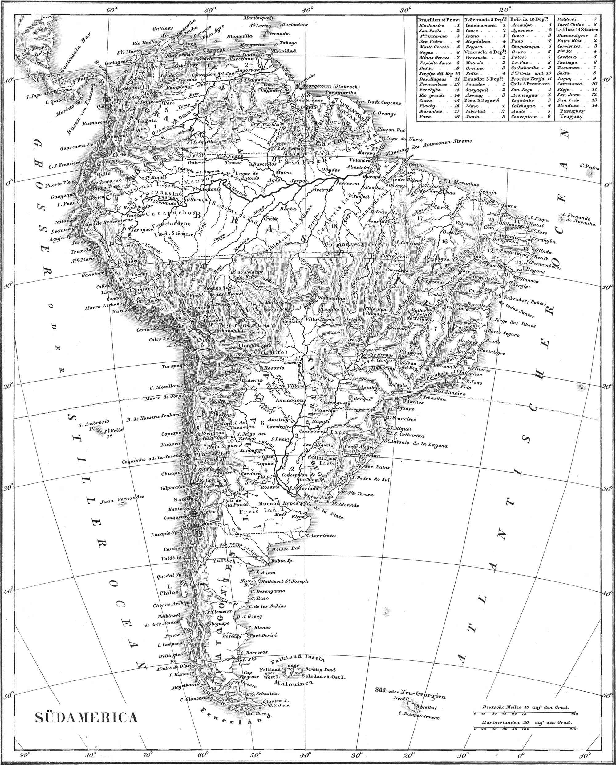
The Three Columbian Republics
The Republic of Columbia, established in 1819, became separated in 1830 into three smaller republics.
- New Grenada, the north-western part, 380,000 square statute miles, pop. 1,687,000, divided into five departments; the cap. is Santa Fé de Bogota, with 40,000 inhabitants.
- Venezuela, 450,000 square statute miles, divided into thirteen provinces; pop. about one million, of which 300,000 are whites, 480,000 mixed, 48,000 negro slaves, 4000 subjected Indians, 50,000 free do., &c.; cap. Caraccas, with 45,000 inhabitants. Here belongs the West Indian island. La Margarita or Margaretha, 399 square statute miles, with 14-19,000 inhabitants, together with several other smaller islands.
- Ecuador or Quito, area 325,000 square statute miles, pop. 325,000, formerly divided into three departments, now into eight provinces; cap. Quito, with 70-80,000 inhabitants.
Guyana or Guiana
By this is to be understood the territory belonging to England, France, and the Netherlands, situated between Venezuela and Brazil, with an area of 163,800 square statute miles, and a pop. of 250,000 (160,000 negroes), exclusive of the free Indians. Maroon-negroes or runaway slaves are numerous in the forests.
- British Guiana has an area of 98,700 square statute miles, and a pop; of 100,000, among which 7000 are whites. It is divided into three colonies: Demerara, Essequibo, and Berbice, cap. Georgetown, with 20,000 inhabitants.
- Netherlandish Guyana or Surinam, area 35-37,800 square statute miles, and a pop. of only 70,000; of this, 60,000 are slaves; cap. Paramaribo, with 20,000 inhabitants.
- French Guiana or Cayenne, 27–29,400 square statute miles, pop. 22,000, of which 15,000 are negro slaves; cap. Cayenne, on a small island.
Empire of Brazil
The area of this enormous state, the second in point of rank in America, amounts to 2,300,000 square statute miles, and the pop. to 5,200,000, without including the wild Indian tribes. Brazil was a Portuguese territory from the sixteenth century; from 1815 it was a kingdom; and since 1822 it has been an independent state, with a representative government, and an emperor. Since 1831, the emperor has been Don Pedro II., of the House of Braganza, brother of the reigning Queen of Portugal. The map exhibits the eighteen provinces into which the empire is divided. The capital city is Rio Janeiro, with 150,000 inhabitants; next to it, in point of size, come the two towns of Bahia, with 80,000, and Pernambuco, with 60,000 inhabitants.
Republic of Peru
With an area of 524,000 square statute miles, this state has a population of 1,374,000 souls. This consists chiefly of Creoles, Mestizoes, Mulattoes, Indians, and Negroes, all of whom, with little exception, profess the Roman Catholic religion. Our map presents the three departments, Lima, Libertad, and Junin; but recent geographers add four more provinces, Arequipa, Ayacucho, Cuzco, and Puno; and others again, the departments, Amazonas, Anchas, Guancavelica, and Mosquegna; cap. Lima, with 40,000 inhabitants.
Republic of Bolivia
Under Spanish government this country was called Upper Peru; but becoming free in 1825, it took the name of Bolivar, which was subsequently changed to Bolivia. It covers an extent of 318,000 square statute miles, and has a pop. of 1,700,000 souls, more than half of which are tributary Indian tribes. The cap. is Chuquisaca, formerly termed Charcas or La Plata (pop. 13,000). Other important towns are Potosi, with 14,000, La Paz de Ayacucho with 32,000, and Cochabamba, with 30,000 inhabitants.
Republic of Chili
This strip of coast land embraces an area of 144,000 square statute miles, with a pop. of about 1,200,000. The state is divided into eight provinces: 1. San lago, with the cap. Santiago (pop. 60,000), and the important harbor of Valparaiso. 2. Aconcagua, cap. Ciudad de Felipe. 3. Coquimbo, the largest province, cap. Coquimbo, or Ciudad de Serena, pop. 11,000. 4. Colchagua, cap. Villa de Curico. 5. Maule, cap. Villa de Cauquenes. 6. Concepcion, cap. Concepcion. 7. Valdivia, cap. do. 8. Chiloe-Archipelago, consisting of seventy-three islands, of which thirty-six are inhabited by 45 to 50,000 persons. The principal island, Chiloe, has an area of 4200 square statute miles, cap. Ciudad de Castro. Further south lie the Chonos and Guayanecas Islands, and about 460 miles off the coast are the two Juan Fernandez Islands, Masatierra and Masafuero.
United States of the Rio de la Plata
The Argentine Republic has an area of 726,000 square statute miles, with 675,000 inhabitants, exclusive of some 1,500,000 Indians. The Gauchos, descendants of Spaniards, are remarkable for living almost entirely on horseback, and for the skill with which they use the lasso. Prominent Indian tribes are the Abipones, Guayanas, Tupis, and Charruas, in the north; and the Pampas Indians in the south. The confederacy embraces the following states: 1. Buenos Ayres, or Argentina in its restricted sense, with 168,000 inhabitants; cap. do., with 85,000 inhabitants. 2. Entre Rios, cap. Parana. 3. Corrientes, cap. do. 4. Santa Fe, cap. do. 5. Cordova, cap. do. 6. St. Iago del Estero, cap. do. 7. Tucuman, cap. San Miguel. 8. Salta, cap. do. 9. Juguy, cap. San Salvador de Juguy. 10. Catamarca. 11. Rioja. 12. San Juan de la Frontera. 13. San Luis de la Punta. 14. Mendoza; all with capitals of similar names.
Republic of Paraguay
This state, so long under the rule of the celebrated dictator. Dr. Francia (deceased in 1840), during which it was entirely inaccessible to foreigners, is the only one in America which does not touch the sea in some point. Its area amounts to 74,000 square statute miles, its pop. to 250,000. The capital is Asuncion, with about 10,000 inhabitants. The individual departments are Asuncion, Concepcion, San Iago, Villarica, Caruguatay, Candelaria, San Fernando, and Santa Hermengilda.
(Oriental del) Uraguay
This state, recognised as independent since 1828, and known under the names of Banda Oriental, Montevideo, and Cisplatina, has an area of 120,000 square statute miles, and a pop. of 140,000, which is mostly European (French, Italian, English), with but few Indians and Negroes. The republic is divided into nine departments: Montevideo, Maldonado, Canelones, San Jose, Golonia del Sagramento, Soriano, Paysandu, Duranjo, Cerro Largo. The capital is Montevideo, with 20,000 inhabitants.
Patagonia
By this is to be understood the southern extremity of America, below the parallel of 38° S. lat. It embraces an area of some 105,000 square statute miles, and is inhabited solely by native tribes. Those in the west are termed Moluches; the eastern are the Patagonians, or Tehueihets, once celebrated for their size, although the narrations of the earlier voyagers in this respect do not appear to be borne out by the experience of the present day. There are no settlements of Europeans.
Terra del Fuego
The Straits of Magellan separate Patagonia from Terra del Fuego, which consists of eleven large and about twenty small islands, with a total area of about 31,500 square statute miles. On the island l’Hermite is situated the most southern land of America, Cape Horn. The inhabitants are the rude and savage Pescherahs, scarcely 2000 in number. On Staatenland the English have a settlement.
To the east of the Straits of Magellan are situated the Falkland Islands, two large and eighty to ninety small islands, in possession of England, and covering an area of 3360 square statute miles. Of the two large islands, the western is called Falkland, the eastern Soledad. Seat of government, Port William.
Australia Plate. 32
This continent, sometimes called New Holland, is situated between the parallels of 10° 40′ and 39° S. lat., or entirely within the southern hemisphere. Its area amounts to about 2,240,000 square geographical miles; to 2,560,000 square geographical miles, however, if we include the innumerable small islands which may be referred to it as the centre. The inhabitants, whose numbers are unknown, are chiefly Malays, among which we distinguish two classes: the Malays proper, or Australian Indians, of lightish color, and the more or less black Papuas or Australian Negroes. The latter live principally on the mainland and the western islands. The number of Europeans probably exceeds 200,000.
East Australia or New South Wales
The English have here had a colony of criminals, in the southern part of the east coast, since 1788; it is this district only, divided into nineteen counties, or New South Wales proper, that is known with any degree of precision. In 1837, there were 37,830 convicts, and 47,270 free people: of these 54,600 were Protestants, and 21,900 Roman Catholics. In 1845. the English population amounted to 181,500. The capital is Sidney, with 26 to 30,000 inhabitants in the county of Cumberland. Other important towns are Paramatta and Bathurst.
South Australia
The English have had a settlement here since 1836, the capital of which is Adelaide. In 1842, with an area of 113,040 square geographical miles, it possessed a pop. of 15,000. The European population, at the end of 1849, was estimated at 25,000. East of this is the colony of Australia Felix, established in 1839; cap. Melbourne. West of South Australia lies Nuyts Land, with a colony at Port Raffles, settled in 1827.
Western Australia
Since 1828, there has been an English settlement in Leeuwin’s Land, on the southern part of this coast, which now embraces twenty-six counties in an area of 75,360 square geographical miles, cap. Perth. The whole colony contained 3476 inhabitants in 1842. The coast north of this is called, in order of succession, Blaming’s Land, Edel’s Land, Eendracht’s Land (the first discovered part of the coast by the Netherlanders in 1616), Dewitt’s Land, and Tasman’s Land.
North Australia
In 1824, the English took possession of the peninsula to the west of the Gulf of Carpentaria, called Arnhem’s Land and Van Diemen’s Land, together with the islands of Melville and Bathurst. On the peninsula of Coburg is situated the town of Victoria. East of the Gulf of Carpentaria is the entirely unknown Carpentaria Land.
Islands in the Vicinity of the Mainland
1. Van Diemen’s Land, or Tasmania, separated from the south-eastern point of Australia by Bass Strait, embraces about 19,200 square geographical miles, and since 1805 has been colonized by the English. It now counts over 50,000 inhabitants, of which 18,700 are convicts; cap. Hobart-town, with 14,500 inhabitants. The island is divided into nine districts. 2. Fourneaux Islands, at the eastern entrance of Bass Strait. 3. King’s Island, at the western entrance of Bass Strait. 4. Kangaroo Island, on the coast of South Australia.
Inner Series of Australian Islands
1. New Guinea, north of New Holland, and separated from it by Torres Strait, next to New Holland is the largest island of the south seas. It includes an area of about 160,000 square geographical miles, which, however, excepting a few points along the coast, is entirely unknown. The inhabitants are partly Malays, under the names of Haraforas, Alfoaras, and Alfakis, partly Papuas and partly Badschus (wandering fishermen). 2. Admiralty Islands, north-esist of New Guinea, about thirty in number, with the Hermit Islands. 3. Archipelago of New Britain, consisting of New Britain (the largest), New Ireland (Tombara), and New Hanover, the total area of which amounts to 18,000 square geographical miles. The inhabitants are Papuas. 4. Archipelago of the Louisiade, south of New Britain. 5. Solomon’s Islands, or New Georgian Islands, south-east of New Ireland. Near them lie the Arsacides. 6. Islands of Queen Charlotte, or Archipelago of Santa Cruz, east of the preceding. The largest island is Santa Cruz or Egmont. To the south-east lies the island of Wanikoro or La Perouse (also called Recherche). 7. The New Hebrides, nine large and many small islands, south of the preceding. The largest island is Espiritu Santo; next to it comes Mallicollo. Banks and Torres Islands belong here. 8. New Caledonia, south-east of the preceding, 4800 square geographical miles, to the east of which lie the Loyalty, Cypress, Plant, Walpole, and Matthew’s Islands.
Outer Series of Australian Islands
1. Mariannes or Ladrones, 14–20 islands, of about 912 square geographical miles, in possession of Spain. Only two or three of them are inhabited. On the Guam, the largest and most southern, is situated the capital, San Ignacio d’Agana; the population amounts to about 5000. 2. The Carolines, or New Philippines, separated from the Mariannes by the Caroline Straits, a group of several hundred diminutive islands, claimed but not settled by Spain. 3. The Pelews, west of the Carolines, more than twenty inconsiderable islands. The largest are termed Babeltuab and Corure. 4. Lord Mulgrave’s Archipelago, consisting of two groups: the Radack and Ralick Islands in the north, sometimes called the Marshall Islands, and the Gilbert’s Islands, in the south. The number of the latter amounts to seventy. In the vicinity lie the Brown’s group, as also the Fisher, Kutusow, and Suwarow Islands. 5. The Fejee Islands, to the south of Gilbert’s Islands and east of the New Hebrides, 200 and more in number. Nearly all are small, but well settled; the largest is Pau. 6. The Tonga or Friendly Islands, south-east of the preceding; 32 large and over 100 small islands, of which Wauwau, Lifuga, and Tonga-Tabu, are the largest. The inhabitants are of a light brown color, friendly disposition, and somewhat civilized; they number over 200,000, with a king at their head. 7. The Samoa, or Sailor’s group, north-east of the preceding, eight small but densely populated islands, of which Pola or Otawhi, Ogalava, and Mauna, are the largest. 8. Cook’s Islands, south-west of the last group. 9. The Archipelago of the Low Islands consists mainly of coral rocks, but little known. They are probably the most recent of the Australian islands. The southern group has received the name of the Dangerous Islands. Here belong the Palliser Islands, and Pitcairn’s Island lying out of the torrid zone. 10. The Society Islands, fourteen large and numerous smaller islands, discovered since 1606, and most visited and best known of all the south sea islands. The population, governed by a king, amounts to 100,000 persons, some of which are of dark brown, some of light olive, nearly white complexion; they are of good disposition, and have been brought within the pale of civilization by English and American missionaries. The islands are divisible into two groups; a, the south-eastern, called George’s Islands, including Otaheite or Tahiti, the largest of all, 420-525 square statute miles, and very fertile, now under the so-called protection of the French; Eimeo, 52 square statute miles, and 1500 inhabitants; Tabuai, Manu, Maitia, and the five Tetuaro Islands, b. The north-western group, with Rajatea, 52 square statute miles, pop. 1800; Taha, 31 square statute miles; Huaheine, 26 square statute miles, with 1800 inhabitants; Borabora, 14 square statute miles, pop. 1000; Maurua, 10 square statute miles. 11. Mendaña’s Archipelago, consisting of two groups: a, a southern, the Marquesas Islands, five islands of 2352 square statute miles (the largest is Hiwaoa, or St. Dominica, the most visited Tahuata or St. Christina, owned by France since 1841); b, the eight Washington or New Marquesas. The largest of these is Nukahiwa, with 18,000 inhabitants, occupied by the French since 1843.
Scattered Islands
- New Zealand, to the south-east of New Holland, consists of two islands, separated by Cook’s Strait: Ikanamauwi or North, and Tawai-Punamu or South Island. The two together embrace an area of about 64,000 square geographical miles, with a pop. of 130,000. These are of light brown color, and of very savage disposition. The English have taken possession of the island since 1840; since when, numerous colonies have started up on the northern island, including over 10,000 Europeans. There are two towns. Nelson and Wellington, of which the latter is the capital. Here belongs Stewart Island, to the south of the southern island. In the vicinity lie: in the north, Norfolk Island (with an English convict colony), and the three Kermandic Islands; to the south-east, Chatham Island, Bounty Island, and Antipodes Island; in the south, the Auckland and the Macquarie Islands. The latter are the most southern of all the Australian islands.
- The Sandwich Islands in the Pacific Ocean, thirteen in number, with an area of 5270–6330 square statute miles, and a population of 120–150,000 (among them 90,000 Christians). These belong to the Malay race, are of a dark color, fine figure, and far advanced in civilization, through the agency of missionaries. In 1830, there were 30,000 of the inhabitants who could read. The islands form a monarchy under a king (now Tameamea III.); the Christian is the state religion. The largest island is Hawaii, or Owyhee, with an area of about 4220 square statute miles, and 85,000 inhabitants. On the island of Oahu, 527 square statute miles, and with a pop. of 28,000, is the royal residence, Honolulu, with 10,000 inhabitants. The largest of the remaining islands are Maui, area 633 square statute miles, pop. 25,000; Tawai, area 527 square statute miles; Morotai, area 168 square statute miles; and Ranai, area 105 square statute miles.
- Eastern Island, or Waihu, and the uninhabited island Sala y Gomez, are the most eastern of all the Australian islands.
![]() Planography, Plans of the Principal Cities of Europe
Planography, Plans of the Principal Cities of Europe
 Planography, Plans of the Principal Cities of Europe
London

London, the largest city in Europe, and the capital of the British Empire, is situated on both banks of the Thames, about sixty miles from where it empties into the North Sea. The population amounts to over two millions (the London Police District, in 1849, included even 2,336,960), among which are only about 8000 soldiers. It consists of three portions: the city in the north and east, Westminster in the west, both on the north bank of the Thames, and Southwark on the south bank; the last belongs to the County of Surrey. The City, or Old Town, of an area equal to one square mile, is divided into twenty-six districts. It is contracted and irregularly built, but constitutes the heart of the city or the principal seat of commerce. The principal streets are Cheapside and Fleet street. The most conspicuous buildings are St. Paul’s Cathedral, the largest Protestant Church in the world, 500 feet long, 250 feet broad, and 356 feet high, with a dome 282 feet high, 140 broad, and resting upon thirty-two columns; it contains fifty monuments, among them one of Nelson, who is here buried. There are, likewise, the Tower, on the Thames, an old citadel, and formerly the royal residence, containing many dwelling houses, the Magazine, the Mint, the Public Archives, prisons of state; the Bank; the new Exchange, 293 feet long, 175 broad, with a portico, a tower 160 feet high, and a place of assembly 270 feet long and 112 wide; Guildhall, with a hall 153 feet long, 48 broad, and 55 high, capable of accommodating several thousand persons; the Custom House, 480 feet long, with a beautiful façade, and a hall 190 feet long and 66 broad; the East India House; Newgate Prison (capable of containing 900 persons). In the city is also the Monument, a column of marble 200 feet high, in commemoration of the great fire of 1666.
Westminster, the finest and most regularly built part of London, is divided into sixteen districts. The principal streets are the Strand; Piccadilly, with the Burlington Arcade, 600 feet long, and lighted from above with glass windows; Regent street, Oxford street, and New Bond street. The principal squares are Covent Garden, Hanover, Charing Cross, with the equestrian statue of Charles I, Lincoln’s Inn Fields, St. James’s square, with the statues of the Duke of York and William III.; Russell square, Grosvenor square, with the statue of George II. on horseback, &c. The principal buildings are St. James’s Palace, a royal residence since 1695, and Buckingham House, the residence of the queen, in St. James’s Park; Westminster Abbey, where the sovereigns of England are crowned and buried, a master-piece of Gothic architecture, 390 feet long, with forty-eight marble columns and many chapels; the immense new Houses of Parliament, built in the Gothic style on a terrace along the Thames, with the statue of Canning in front; Westminster Hall; the Admiralty Building; St. Martin’s, St. Pancras’, St. Stephen’s, St. Ann’s, St. George’s, and St. Margaret’s Churches; the British Museum, with a large library (3–400,000 vols., and 50,000 manuscripts), and one of the finest collections of Natural History and of Art in the world; the National Gallery in Trafalgar square, 461 feet long, and 56 feet broad; the University Building, 430 feet long, with chapel, library, and dining hall; the Pantechnicon, 500 feet long, with numerous shops; the three principal theatres, Queen’s Theatre or the Italian Opera House, for 2400 persons, Covent Garden, and Drury Lane, the latter capable of containing 3,000 spectators; the Barracks of the Guards. The finest private house is the palace of the Duke of Northumberland; next to it comes Apsley House, the palace of the Duke of Wellington, with those of Lords Marlborough, Bedford, Stafford, Spencer, &c.
Southwark, the southern part of London, inhabited, by the poorest and humblest part of the population, has but few buildings of any note, besides Lambeth House (residence of the Archbishop of Canterbury), and the Queen’s Bench (Court of Justice), with numerous prisons. Other portions of London, arising from the incorporation of individual villages, lie to the west, north, and east, about the city and Westminster. They may be divided into three divisions or parishes: Holborn, including Marylebone, Paddington, and Pancras, and called West End, from lying west of the city; Finsbury, north of the city, with Clerkenwell, Finchley, Islington, &c.; Tower Hamlets, east of the city, and therefore called East End, with Bethnal Green, Hackney, Limehouse, Shoreditch, Stratford, Stepney, Spitalfields, Wapping. On the south bank of the Thames lie also Lambeth, Battersea, Camberwell, Clapham, Wandsworth, Rotherhithe. &c., which together constitute the Brixton division.
Six bridges cross the Thames for the purpose of accommodating the northern and southern parts of the city. These are, from west to east: 1, the iron Yauxhall Bridge, 861 feet long, with nine arches; 2, Westminster Bridge, 1223 feet long, 48 feet broad, with 14 piers; 3, the superb Waterloo Bridge of dressed granite, 1248 feet long, with 9 large arches; 4, Blackfriars’ Bridge, 995 feet long, with 9 arches; 5, the iron Southwark Bridge, with three arches, the middle one of which has a span of 240 feet; 6, London Bridge, 928 feet long, 52 feet broad, with five arches. To the east, there is the Tunnel, constructed by Brunei in 1824–42, between Rotherhithe and Wapping, 1300 feet long, 34 feet beneath the bed of the river, divided into vaulted galleries, 13f feet broad, and 16\(\frac{1}{3}\) feet high each.
The most frequented promenades are: 1, St. James’s Park, with a beautiful gate of marble, and the equestrian statue of George IV.; 2, Green Park; 3, Hyde Park, reaching to Kensington, 395 acres in extent, with a statue of Achilles eighteen feet high, and one of Wellington on a pedestal 150 feet high; 4, Regent’s Park, 360 acres, newly laid out, in the West End (here are situated the Botanic Garden and Zoological Gardens).
The immense docks, or artificial basins for the reception of vessels, deserve especial mention. Of these, there are the West India Docks, covering 24 acres, the London Docks, of 20 and 14 acres, the East India Docks, and St. Catharine’s Docks, of 11\(\frac{1}{2}\) acres, &c. They are all surrounded by gigantic warehouses.
Explanation of the Plan.
Bridges.
- Battersea or Chelsea bridge.
- Vauxhall bridge.
- Westminster bridge.
- Hungerford bridge (suspension).
- Waterloo bridge.
- Blackfriars’ bridge.
- Southwark bridge.
- London bridge.
Docks and Basins.
- South dock.
- Timber docks.
- Commercial docks.
- Grand Surrey outer dock.
- Grand Surrey inner dock.
- Greenland dock.
- East county dock.
- and IX. West docks.
- Mast pond.
- East and west docks.
- Mill pond.
- London docks.
- East London dock.
- St. Catharine’s dock.
Squares.
- Grosvenor square, with the statue of King George II.
- Portland square.
- Berkeley square, with the statue of King William III.
- St. James’s square.
- Hanover square.
- Manchester square.
- Cavendish square.
- Golden square.
- Soho square, with the statue of King Charles I.
- Bedford square.
- Bloomsbury square, with the statue of the minister Fox.
- Russell square.
- Tavistock square.
- Gordon square.
- Easton square.
- Brunswick square.
- Mecklenburg square.
- Red Lion square.
- Lincoln’s Inn square.
- Trinity square.
- Wellclose square.
- Finsbury square.
- Smithfield square.
- The Oval.
Public Buildings.
- St. Paul’s Church.
- The Tower.
- New Mint.
- Bank.
- The Lord Mayor’s House.
- House of the East India Company.
- Exchange.
- Custom House.
- Guildhall.
- London Institute.
- St. Luke’s Hospital.
- Charter House Hospital.
- St. Bartholomew’s Hospital.
- Fleet Prison.
- Entrance to Temple Garden.
- Westminster Abbey.
- Parliament Houses.
- St. James’s Palace.
- Royal Palace.
- Somerset House.
- Admiralty.
- War Department.
- Treasury.
- British Museum.
- University of London.
- Colosseum.
- Diorama.
- House of Correction.
- Chelsea Hospital.
- Guy’s Hospital.
- St. Thomases Hospital.
- Magdalene Hospital.
- Bethlehem Hospital (Bedlam).
- Queen’s Bench Prison.
- Vauxhall.
- Temple Gardens.
- Gray’s Inn Gardens.
- Zoological Gardens.
- Ranelagh.
- Deaf and Dumb Institute.
- Blind Institute.
- Surrey Theatre.
- Astley’s Theatre.
- Italian Opera House.
- Covent Garden Theatre.
- Drury Lane Theatre.
- Lyceum or English Theatre.
- Adelphi Theatre.
- West Theatre.
- Pantheon.
- London Monument.
- St. George’s Church.
- St. Paul’s Cathedral.
- London Hospital.
- St. Stephen’s Chapel.
- Jew’s Hospital.
- St. Leonard’s Church.
- Alms House.
- St. Luke’s Workhouse.
- Sadler’s Wells Theatre.
- Polygon.
- Park square.
- Statue of the Duke of Kent.
- Marylebone Church.
- Wellington’s Monument.
- St. George’s Hospital.
- Lock Hospital.
- Invalids’ Hospital.
- New Bridewell.
- Lambeth Palace.
- Elephant and Castle.
- St. John’s Church.
- Church of Mary Magdalene.
- Jenkins’s Nursery.
Streets.
- Waterloo.
- Grand Surrey.
- Westminster.
- Borough.
- Lambeth.
- New Camberwell.
- Kennington.
- Walworth.
- New Kent.
- Old Kent.
- St. George’s.
- Long Lane.
- Tooley.
- West India Dock.
- Radcliffe Highway.
- New street.
- Handel’s.
- White Chapel.
- Mile End.
- Hackney.
- Bethnal Green.
- Shoreditch, Kingsland.
- Bishopsgate.
- Thames.
- Cheapside.
- Newgate.
- Holborn.
- Oxford.
- Pity.
- Goswell.
- Aldersgate.
- New.
- Gray’s Inn Lane.
- Seymore.
- Hampstead.
- Tottenham Court.
- Portland Place.
- Regent.
- Wimpole.
- Bond.
- Baker.
- Gloucester.
- Park.
- Rawford.
- Devonshire.
- Audley.
- Piccadilly.
- St. George.
- Whitehall.
- Vauxhall.
- Belgrave square
- King.
- Sloane.
- Brompton.
- Marlborough.
- Clarence.
- Grove.
- Edgeware.
- Great Union.
Principal Divisions of the City.
- City proper.
- Westminster.
- Southwark.
Paris
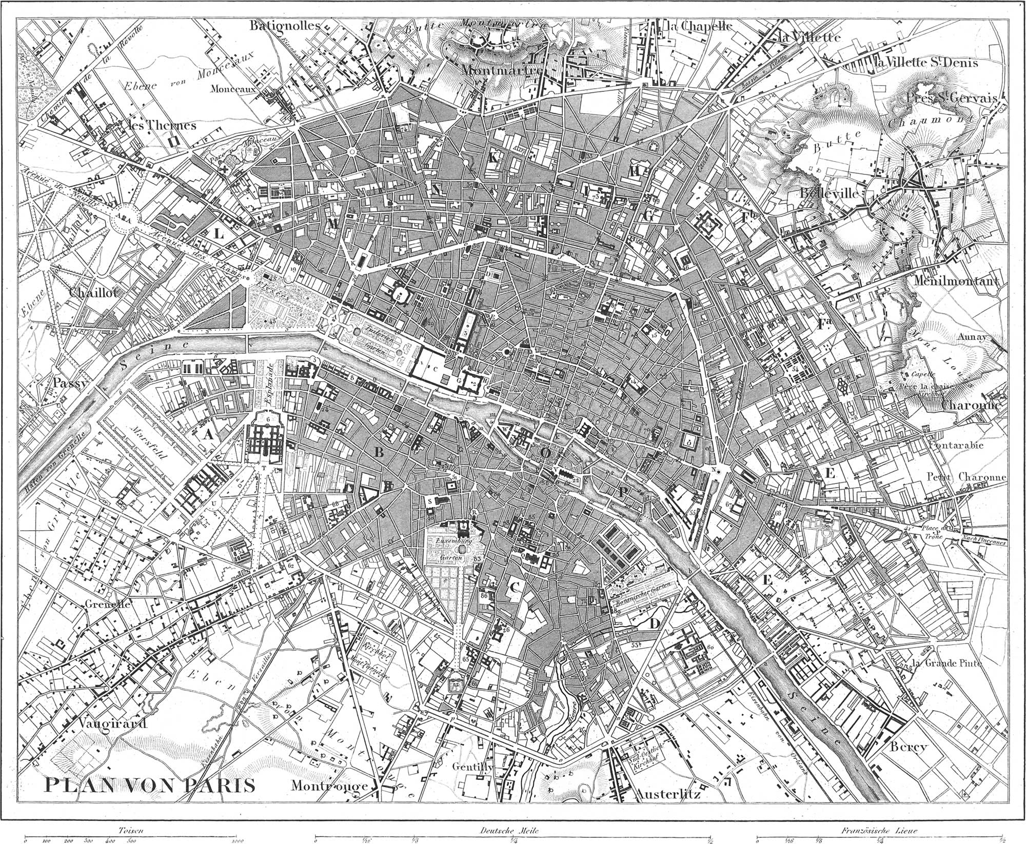
Paris, the time-honored capital of France, lies in a plain traversed by the Seine. At the last census, of 1846, it had a population of about 1,053,897 inhabitants, amongst which 945,721 belonged to the fixed population, and 88,475 to the floating, or those in schools, hospitals, &c.; and 19,701 to the garrison. Paris is about fourteen miles in circumference, with an area of three millions and a half of hectares, and is divided into twelve Mairies or Arrondissements, with forty-eight Quartiers or Police districts. The Seine separates it into a south and north part, the latter of which is the larger. It is inclosed by a continuous wall, twelve to sixteen feet high, through which lead fifty-eight entrances or Barrieres. The city contains 30,000 houses, 113 churches and chapels, 43 public libraries, 40 convents, 22 theatres, 27 hospitals, 33 barracks, 22 bridges, 80 fountains, more than 80 public squares, and some 1700 streets and quais. The principal points of interest are as follows:
- In the City Proper, north of the Seine: the Tuileries, formerly the residence of the French king, 1071 feet long, with a garden 2000 feet in length; the Louvre, 525 feet long, united with it by a superb building with a colonnade 1332 feet in length, and containing the antique museum, the galleries of paintings (in a hall 1332 feet long), of antiquities, of models of ships, of plaster casts, of designs, and of recent statuary; the Palace Elysée Bourbon, formerly the palace of the Duke of Bourdeaux, now the residence of the President of the Republic; the Palais Royal, formerly the property of the Duke of Orleans, with a court 700 feet long and 300 broad, surrounded by arcades of 180 arches, containing the most brilliant shops, &c.; the Palace of the Bourse, and of the Chamber of Commerce, 208 feet long, adorned with sixty-six Corinthian columns; the Library Building, containing, according to different estimates, from 700,000 to 1,000,000 volumes, and over 80,000 manuscripts, 150,000 coins, and one million and a half of engravings and charts; the great church of St Eustache, with painted glass windows; the beautiful Magdalene Church, 318 feet long, 138 feet broad; the Hospital of St. Louis, with 800 beds; the City Hall or Hotel de Ville. The largest and most beautiful square is the Place de la Concorde (formerly Place Louis XV., and Place de la Revolution), 780 feet long, and adorned with the Obelisk of Luxor, a mass of granite 45 feet high; other beautiful squares are the Place du Carrousel, before the Tuileries, with a magnificent triumphal arch 45 feet high; the Champs Elysées, which leads to the triumphal Arch de l’Etoile, 152 feet long, 138 broad, and 80 feet high; the Place Vendome, 450 feet long, with the Victor’s column of bronze, 140 feet high, and 12 thick, having the statue of Napoleon on the top, access to which is gained by 176 steps; the Place Royale, with the equestrian statue of Louis XIII.; the Place de la Bastille, with the July column of bronze, 158 feet high, and 10 feet thick; the Place Louvois, the Place du Chatelet, and the Marche des Innocens, all with beautiful fountains; the Place des Victoires, with the statue of Louis XIV., &c.
- The Ancient City, or Cité consists of three islands of the Seine. On the largest of these. Cite in a restricted sense, or He du Palais, is situated the grand church of Notre Dame, a masterpiece of Gothic architecture, 390 feet long, 144 feet broad, with a dome 162 feet high, and two towers of 204 feet. Here are also the Palace of the Archbishop; the Palais de Justice; the prison Conciergerie; and the Hospital Hotel Dieu, which contains 1500 beds in twenty-three rooms. The two other islands are termed St. Louis and Louviers.
- In the inconsiderable portion of the city on the south bank of the Seine (Université), are the Museum of Natural History and the Botanic Garden (Jardin des Plantes), with the richest menagerie in the world; the Castle of Luxemburg, with a large and beautiful garden; the Pantheon, or the former church of St. Genoveva, 340 feet long, with a superb dome, supported by 130 columns; the Hospital Salpetriere, for 5000 old women, and the Insane Asylum Bicetre, for 3000 insane persons; the Manufactory of the Gobelins; the Palace of the Chamber of Deputies, with a beautiful hall with columns and extensive gardens, which end in a terrace 1500 feet long; the Observatory, wath a platform 85 feet high; the Hotel des Monnaies or the Mint Building, 360 feet long; the Military School, now Barracks, consisting of six buildings with fifteen courts, 1320 feet long, and 780 feet broad; the Hospital of the Invalides, with a beautiful church, in which is situated the tomb of Napoleon. The Champ de Mars is an extensive square at the west end of the city, 2700 feet long and 900 feet broad, serving for military parades.
The most important of the bridges over the Seine are the bridge of Jena, a stone bridge 460 feet long, the bridge or Pont de la Concorde, 600 feet long, of five arches, and adorned with twelve statues; the Pont Royal; the Pont des Arts, 516 feet long, of nine iron arches; the Pont Neuf, 712 feet long, with the statue of Henry IV., fourteen feet high; the Bridge of Austerlitz, with five iron arches, 400 feet long.
The Catacombs were formerly quarries, from which was obtained the stone used in building the city of Paris. They now constitute an enormous subterranean cemetery, access to which is obtained by a flight of ninety steps. Other points of interest are the Artesian Well in the Slaughter House of Grenelle, 1961 (English) feet deep; the Cemetery of Pere la Chaise, in the eastern part of the city, with 25,000 graves, and innumerable monuments. The following communes are united with the city government: On the right of the Seine, Belleville, Batignolles, Montmartre, La Chapelle, La Villette, Neuilly, Bercy, Passy, Charronne; on the left bank, Baugirard, Chantilly. Mont Rouge, and Grenelle. These lie between the barrieres and the fortifications erected since 1841. The fortifications consist of eighty- five bastions, with walls, ditches, &c. At from 800-2500 paces from the circular wall are sixteen detached forts, mounted with 2208 cannon. Instead of the ancient fortifications, the interior of the city, within the circular wall, is surrounded by ten Boulevards, 36,000 feet long, and planted with trees.
Railroads lead from Paris, on the north bank of the Seine, northward to Versailles (St. Germain and Rouen) and Brussels (Northern Railroad), and eastward to Strasburg; on the left bank of the Seine, south-west to Versailles, south-east to Orleans and Lyons.
Explanation of the Plans.
Paris and its Vicinity.
Suburbs.
- Justice du Gros-Caillon.
- Foubourg St. Germain.
- Foubourg St. Jacques.
- Foubourg St. Marceau.
- Foubourg St. Antoine.
- a. Foubourg du Temple.
- b. Foubourg St. Martin.
- G. Foubourg Ménilmontant.
- Foubourg St. Denis.
- Foubourg Poissonnière.
- Foubourg Montmartre.
- Foubourg au Roule.
- Foubourg St. Honoré.
- Justice de la Chaussée d’Antin.
- Justice de la Cité.
- Justiced de l’Ile St. Louis.
Public Squares.
- Place de la Concorde.
- A.Place et barrière de l’Etoile.
- Place Vendôme.
- Place du Carrousel.
- Place de la Bourse.
- Place des Victoires.
- Place du Palais-Royal.
- Place du Musée.
- Place du Louvre.
- Place de l’Oratoire.
- Place de la Madeleine.
- Place du Châtelet.
- Place de l’Hôtel de Ville.
- Place de la Bastille.
- Place Royale.
- Place du Trône.
- Place du Panthéon.
- Place de l’Odéon.
- Place St. Sulpice.
- Place de Vauban.
- Place de Fontenoy.
- Place du Parvis-Notre-Dame.
- Place Dauphine.
Quays and Streets.
- Quai de la Grève.
- Quai de la Megisserie.
- Quai de l’Ecole.
- Quai du Louvre.
- Quai des Tuileries.
- 1 Quai Cours la Reine, and Quai de la Conference.
- Quai d’Orsay.
- 1 Quai Voltaire.
- Quai Malaquais.
- Quai Conti.
- Quai des Grands Augustins.
- Quai St. Michel.
- Quai Montebello ou Billy.
- Quai de la Tournelle.
- Quai St. Bernard.
- Quai d’Austerlitz.
- Quai de la Rapée.
- Quai Moraud.
- Quai des Ormes.
- Quai de Bethune.
- Quai de l’Archeveche.
- Quai des Orfevres.
- Quai de l’Horloge.
- Quai Napoleon.
- Quai Bourbon.
- Quai d’Anjou.
- Port aux Vins.
- Rue Royale.
- Rue Trouchet.
- Rue Malherbes.
- Rue Rivoli.
- Rue Castiglione.
- 1 Rue de la Paix.
- Rue St. Honore.
- Rue Richelieu.
- Rue Vivienne.
- Rue Montmartre.
- Rue Poissonniere.
- Rue St. Denis.
- Rue St. Martin.
- Rue Rambuteau.
- Rue du Temple.
- 1 Rue vieille du Temple.
- Rue St. Louis.
- Rue St. Antoine.
- 1 Rue du faub. St. Antoine.
- Rue Lafayette.
- Rue du faub. du Temple.
- Rue du faub. St. Martin.
- Rue du faub. St. Denis.
- Rue du faub. Poissonniere.
- Rue du faub. Montmartre.
- Rue Laffitte.
- Rue du Mont Blanc.
- Rue du faubourg du Roule.
- Rue du faubourg St. Honoré.
- Rue d’Arcole.
- Rue de la Seine.
- Rue de l’Université.
- Rue de Vaugirard.
- Rue de Sèvres.
- Rue St. Jacques.
- Rue St. Victor.
Boulevards.
- Boulevard de la Madeleine.
- Boulevard des Capucines.
- Boulevard des Italiens.
- Boulevard Montmartre.
- Boulevard Poissonnière.
- Boulevard Bonne-Nouvelle.
- Boulevard St. Denis.
- Boulevard St. Martin.
- Boulevard du Temple.
- Boulevard des Filles du Calvaire.
- Boulevard St. Antoine.
- Boulevard de l’Arsénal ou de Bourdon.
- Boulevard de l’Hôpital.
- Boulevard Gobelines.
- Boulevard St. Jacques.
- Boulevard d’Enfer.
- Boulevard du Mont Parnasse.
- Boulevard des Invalides.
- Avenue de Breteuil.
- Allée des Veuves.
Bridges.
- Pont de Bercy, ou de la Gare.
- Pont d’Austerlitz.
- Pont de Constantine.
- Pont de Damiette.
- Pont de la Tournelle.
- Pont Marie.
- Pont de la Cité
- Louis Philippe.
- Pont d’Arcole.
- Pont Notre Dame.
- Pont au Change.
- Pont Neuf.
- Pont d l’Archevêché.
- Pont au Double.
- Pont Petit St. Michel.
- Pont St. Michel.
- Pont des Arts.
- Pont du Carrousel.
- Pont Royal.
- Pont de la Concorde.
- Pont des Invalides.
- Pont d’Jena
- Pont de Grenelle.
Public Buildings.
- Palais de Tuileries.
- Palais du Louvre.
- Palais Royal.
- Palais du Luxemourg (Chamber of Peers).
- Palais Bourbon (Chamber of Deputies).
- Hôtel des Invalides.
- Ecole Militaire.
- Palais de la Legion d’Honneur.
- Palais du quai d’Orsay.
- Hôtel des Monnaies.
- Palais de l’Institut.
- Observatoire.
- Palais de Justice.
- Palais Soubise, Archives du Royaume.
- Le Temple.
- Banque de France.
- Ministère des Affaires étrangères.
- Ministère des Finances.
- Elysée-Bourbon.
- Ministère de la Marine.
- Panthéon.
- Hotel-de-Ville.
- Bourse et Tribunal du commerce.
- Garde-Meubles.
Churches.
- Eglise Notre Dame.
- Eglise St. Germain-des-Prés.
- Eglise St. Thomas d’Aquin.
- 1 Eglise St. Valère.
- Eglise St. Etienne-du-Mont.
- Eglise du Val-de-grâce.
- Eglise St. Germain l’Auxerrois.
- Eglise St. Eustache.
- Eglise St. Roche.
- Eglise St. Gervais.
- Eglise St. Paul.
- Eglise Notre Dame de Lorette.
- Eglise St. François de Paul.
- Eglise St. Sulpice.
- Eglise de la Madeleine.
- Chapelle St. Louis.
Theatres.
- Académie Royale de Musique.
- Théatre Italien.
- Théatre François.
- Théatre Ventadour.
- Théatre de l’Opera-comique.
- Théatre de la Porte St. Martin.
- Théatre de l’Ambigu-comique.
- Théatre du Cirque Olympique.
- Théâtre du Gymnase dramatique.
- Théâtre des Varietés.
- Théâtre Cirque de Champs Elysées.
- b. Panorama.
- Théâtre de l’Odéon.
Halls and Markets.
- Entrepôt général.
- Halle aux vins.
- Halle aux blés.
- Marché du Temple.
- Marché des Innocents.
- Marché St. Germain.
- Marché au gibier (game market).
- Marché St. Honoré.
- b. Marché aux chevaux.
- Abattoirs (slaughter-houses).
- Grenier de réserve.
Hospitals.
- Hôtel Dieu.
- Hôpital de la Pitié.
- Hôpital de la Charité.
- Hôpital St. Antoine.
- Hôpital de la Salpétrière.
- Hôpital Cochin.
- Hôpital Necker.
- Hôpital Beaujon.
- Hôpital St. Louis.
- Hospice des Enfants trouvés.
- Hospice des Orphelins.
- Hospice des Quinze-vingts.
- Hospice des femmes incurables.
- Hospice des hommes incurables.
Prisons.
- Prison de la Force.
- Prison Ste. Pélagie.
- Prison des Madelonnettes.
- Prison St. Lazare.
- Prison Clichy (des dettes).
- Prison Modèle.
- Prison du Nouveau Bicêtre.
- Prison Militaire de Montaigne.
Scientific Institutions.
- Sorbonne.
- Ecole de Droit.
- Ecole de Medecin.
- Ecole Polytechnique.
- Ecole des Beaux-Arts.
- Ecole des Mines.
- Ecole de Musique.
- Collège de France.
- Institution des Sourds-muets.
- Conservatoire des Arts et Metiers.
- Bibliothèque Royale.
- Museum d’histoire naturelle.
- Séminaire de St. Sulpice.

Military Plan of Paris
- Palace of the Tuileries.
- Chamber of Peers.
- Chamber of Deputies.
- The Louvre.
- Hôtel de Ville.
- War Department.
- Principal quarter of the first military division.
- Military Intendency.
- Military School.
- Hôtel des Invalides.
- Arsenals and Military Storehouses.
- 12. Principal Quarter of the first Legion of the Nat. Guards.
- 13. Principal Quarter of the 2d Legion.
- 14. Principal Quarter of the 3d Legion.
- 15. Principal Quarter of the 4th Legion.
- 16. Principal Quarter of the 5th Legion.
- 17. Principal Quarter of the 6th Legion.
- 18. Principal Quarter of the 7th Legion.
- 19. Principal Quarter of the 8th Legion.
- 20. Principal Quarter of the 9th Legion.
- 21. Principal Quarter of the 10th Legion.
- 22. Principal Quarter of the 11th Legion.
- 23. Principal Quarter of the 12th Legion.
- Large space intended for Parades and Barracks.
- Strategical ways, connecting the forts.
- Barracks.
- Military Hospital.
- Pont (bridge) de Bercy.
- Pont d’Austerlitz.
- Pont de Constantine.
- Pont de Damiette.
- Pont de la Tournelle.
- Pont Marie.
- Pont de la Cité.
- Pont Louis Philippe.
- Pont d’Arcole.
- Pont Notre Dame.
- Pont au Change.
- Pont Neuf.
- Pont de l’Archevêché.
- Pont au Double.
- Pont St. Michel (Petit).
- Pont St. Michel (Grand).
- Pont des Arts.
- Pont du Carrousel.
- Pont Royal.
- Pont de la Concorde.
- Pont des Invalides.
- Pont d’Jéna.
- Pont de Grenelle.
Observations
- The line outside of the ring wall and of the forts, indicates the breadth of the glacis.
- The first dotted line indicates the breadth of the military district.
- The second dotted line about the forts, indicates the mean musket
range. - The second dotted circular line about the forts, indicates the mean grapeshot range.
- The third dotted circular line indicates the extreme range of the mortars and twenty-four pounders.
- The Bastions of the Ring walls bear the successive numbers, 1–94, beginning at the Seine above Bercy.
Constantinople
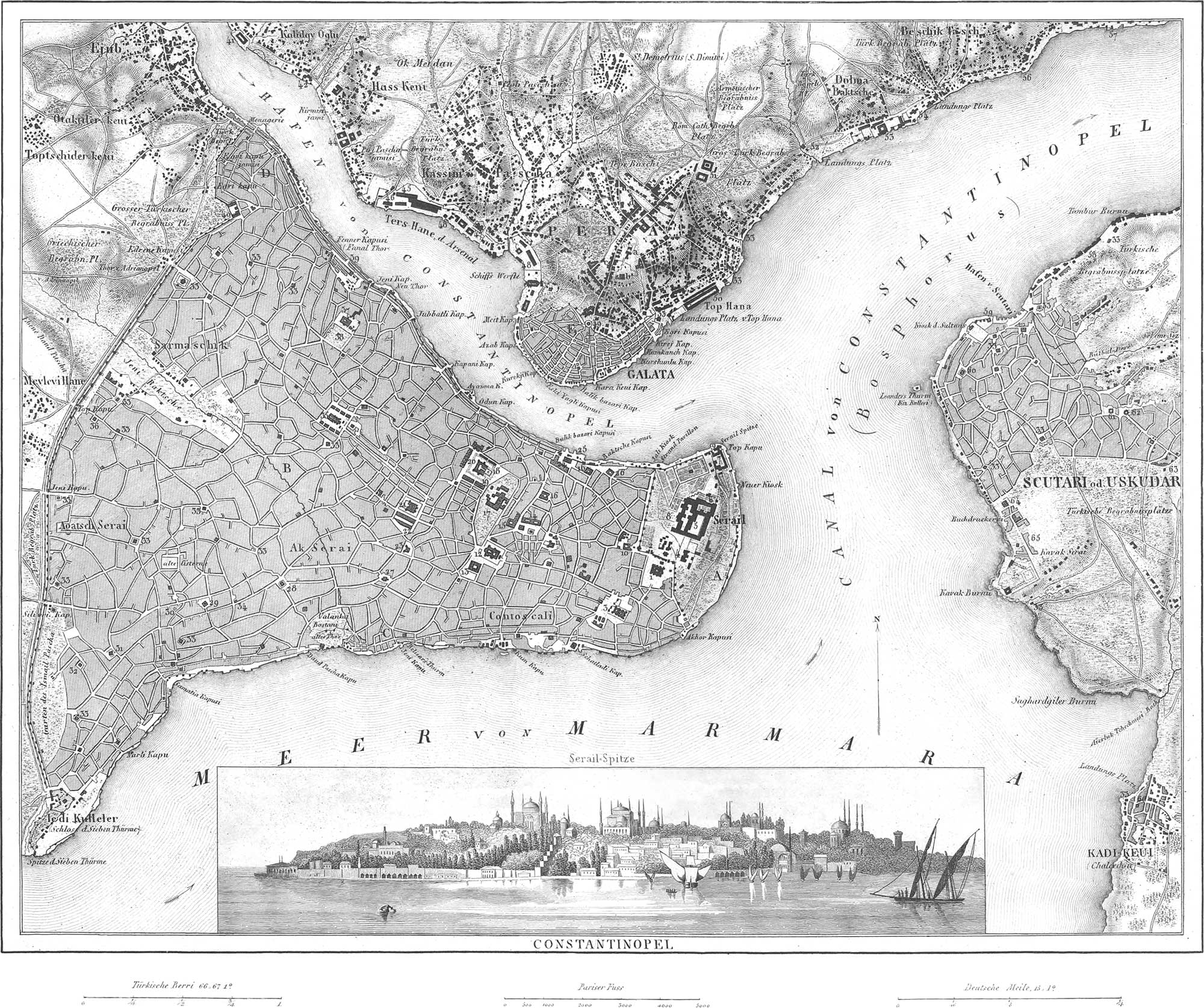
Constantinople, the Turkish Stamboul, the capital of the Turkish Empire, is situated at the southern entrance of the Straits of Constantinople, formerly the Bosphorus. It forms a triangle, the northern part of which is bounded by the Bay of Constantinople, the southern by the Sea of Marmora, while the third side is occupied by fields and gardens. The population, like that of all eastern cities, is hard to determine, although it amounts at least to half a million, of which half are Turks, one fourth Greeks, and the rest Europeans, Jews, and Armenians. The city wall, erected by the Emperor Theodosius, is provided with 548 towers, and protected by a ditch twenty-five feet broad; the walls are doubled on the land side, often trebled, with a space of twenty feet between the walls. The most remarkable part of the city is its extreme point on the sea, which contains the castle of the Grand Turk, called Serai or Seraglio; this is over two miles in circumference, includes a number of gardens, mosques, &c., and is inhabited by some thousands of persons. Near the Seraglio is the residence of the Grand Vizier, the gate of which is called the Sublime Porte. Next to the Seraglio, the most remarkable public buildings are the Mosques, built by the Sultans. Of these there are 517 in all, thirty-six of them large; conspicuous among them is the Hagia Sofia, or the former church of St. Sophia, built by the Emperor Justinian in 538. It is 270 feet long, with a magnificent dome, and 170 columns of marble, granite, &c. Also the Mosque Suleimanje, built in 1550, and a masterpiece of oriental architecture, with thirteen domes; the Mosque Ahmedidje, with six domes (all other mosques having but four). In addition to these, Constantinople has 24 Greek, 9 Roman Catholic, and three Armenian Churches, 183 Hospitals, 101 Cafes, 9 Insane Asylums, 130 Public Baths, 40 Khans or houses of refreshment, &c. The most important bazaar is the labyrinthine Jeni Bazaar, in the middle of the city. The only noteworthy public square is the Atmeidan, 250 paces long, inclosed by pillars, and with an obelisk sixty feet high; this was formerly a circus for races. Of the seven aquedticts, two date back as far as the Grecian times; as also the two colossal cisterns, of which one, entirely in disuse, contains 672 marble pillars, and the other 336. Of the sixteen suburbs, the most important are Pera, the residence of the foreign embassies, and of many European merchants; and Galata, both separated from the town itself by the bay; Tophana; Hassan or Kassim Pasha; Fanar or Fanal, at the point of the bay, where dwell most of the Greeks, hence called Fanariotes. Scutari, on the Asiatic side, separated from Constantinople by the Bosphorus, is also to be looked upon as a suburb.
Explanation of the Plans.
- Seraglio of the Sultan.
- Former quarter of the Janissaries.
- Quarter of the Armenians.
- The Blachernes.
- Quarter of the Franks.
- Mosque of Aja Sofia.
- Church of St. Irene.
- The Atmeidan, with the Mosque of Achmed.
- First Court of the Seraglio.
- Second Court of the Seraglio.
- Imperial Treasury.
- Summer Harem of the Sultan.
- Winter Harem of the Sultan.
- Marble Kiosk of the Sultan.
- Vizier’s Seraglio.
- Mosque of the Sultan Osman.
- Mosque of Sultan Bajazed.
- School Building.
- Ieni Khan.
- Khan of the Sultana Valide.
- Other Khans.
- Old Seraglio.
- Mosque Suleimanje.
- Coffee Houses.
- Hospital.
- Mosque Khalilzade.
- Former barracks of the Janissaries.
- Laleli-dschamisi.
- Mosque of Sultana Valide.
- Custom House.
- New Imaret.
- Budrun-dschamisi.
- Mosque Achmed Hissar.
- Mosque Daud Pasha.
- Mosque Hekim Oghli.
- Mosque Mustafa.
- Mosque Ismail Pasha.
- Mosques and Houses of Prayer.
- Column of Arcadius.
- Mosque of Mohammed and Tawkhane Hospital.
- Meidan dschamisi Seraglio.
- Mosque of Selim.
- Ancient Cisterns.
- The Fanal (Lighthouse).
- Tekfur Seraglio, former palace of Constantine the Great.
Suburb of Galata.
- Barracks of the Bombardiers.
- Old Cannon Foundry.
- Engineers’ School.
- New Cannon Foundry, with the Administration Buildings.
- Magazines and Ropewalks.
- School Building.
- Seraglio of the Capudan Pasha.
- Magazines and Wharfs.
- Tower of Galata.
- Old Artillery Barracks.
- New Artillery Barracks.
- Mosque, Coffee Houses, and Fountains.
- Palace of Beshik-Tash.
- Mosque Mustaffa Effendi.
- Mosque Sinan Pasha.
- Palace of Sultana Begum.
- Palace of Sultana Valide.
Suburb of Pera.
- Hotel of the French Embassy.
- Hotel of the Austrian Embassy.
- Hotel of the Holland Embassy.
- Hotel of the English Embassy.
- Hotel of the Norwegian-Swedish Embassy.
Scutari.
- Granaries.
- Mosque Shemsi Pasha.
- Ibrik dschamisi.
- Khan of the Sultana Mother.
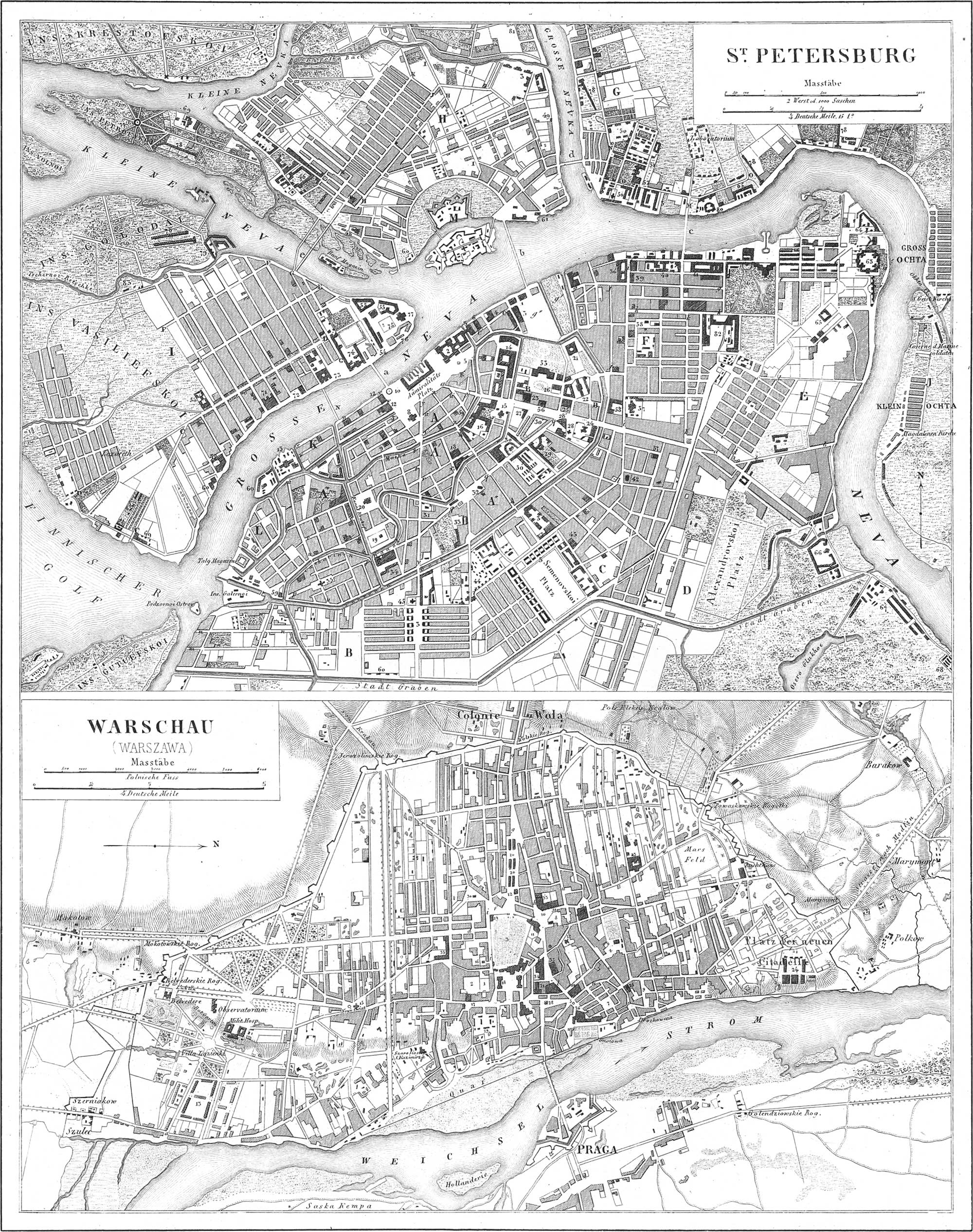
St. Petersburg Plate 37
St. Petersburg is one of the most beautiful cities in Europe, not on account of its position, but by merit of its superior plan and architectural features. It is the most important commercial place in the Russian Empire, of which it is also one of the capitals. It is situated between the Lake of Ladoga and the Gulf of Finnland, near the mouth of the River Neva. It has a circumference of nearly sixteen miles, with a population of some 450,000, amongst which are only about 150,000 females; there are 120,000 peasants, 75,000 military persons; 25,000 Lutherans, 23,000 Roman Catholics, 8000 Reformed, 2,200 Mohammedans, 570 Jews; 3000 French, 2700 English, 20–25,000 Germans, &c. Of its 8700 houses, 5400 are of wood; there are ten imperial palaces, over 750 government buildings, 304 police stations, 163 churches and chapels, amongst them but twelve Protestant and Roman Catholic. The city is divided into thirteen districts, of which nine lie on the southern bank of the Neva; two form islands, Petrofskoi and Wasiliefskoi-Ostrow; between the Neva and Newka; one lies north of the Neva, and is not yet fully built up; the thirteenth district is the former village of Ochta on the Neva. In all, excepting the last, which has been but recently drawn into the city, the streets are straight and broad. The finest street is the Newsky-perspective, 15,000 feet long, and 140–150 feet broad, abounding in the most brilliant shops. The finest parts of the city are the four Admiralty Districts, between the Neva and the Fontanka Canal; in these are situated the Imperial Winter Palace, 450 feet long on the Neva; in front of it stands the immense column in honor of Alexander I., eighty-four feet high and thirty-six feet thick, wrought of a single mass of granite; the Hermitage, with a very valuable collection of paintings, and a library of 100,000 volumes; the Marble Palace, built of granite and coated with marble, and with a copper roof; the Palaces of the Grand Prince Michael, and of the Duke of Leuchtenberg; the immense Navy Yard, with workshops for shipbuilding, magazines, and docks. Some of the other numerous public buildings are the Imperial Foundling Hospital for 5000 children; the Imperial Public Library, with 450,000 volumes and 18,000 manuscripts; the Royal stables, with accommodations for 1500 horses; the Taurian Palace, formerly belonging to Prince Potemkin, with a collection of antiquities; the large bazaar, Gostinnoi Dwor, with arcades and 170 shops; the Exchange, on the island of Wasiliefskoi-Ostrow, 330 feet long and 246 feet broad, with forty Doric columns, and a hall 136 feet long; the building of the Academy of Arts; the fine University building; the Land and Sea Cadet House, the former for 700, the latter for 350 pupils. The principal churches are St. Isaac’s Church, built entirely of marble and metal, with 112 granite columns, 56 feet high, each one cut from a single block, and with a dome 330 feet high and 100 feet in diameter, one of the largest and most magnificent churches in the world; the Church of Our Lady of Kasan, with marble floor and fifty-six granite columns, together with an external, semi-circular portico of 130 columns; the Church of St. Nicholas, of two stories, the lower of which can be heated; St. Peter-Paul’s Church, with the imperial vault, in which all the Emperors are entombed, and with a spire, 330 feet high, gilded at the expense of 60,000 ducats; the Church of the Order of Alexander-Newsky; also an imperial burying-place, containing the silver tomb of St. Alexander. Of monuments and statues, in addition to those already mentioned, the principal are the bronze equestrian statue of Peter the Great, on a single block of granite, 17 feet high, and weighing 1500 tons; the monuments of the Marshals Suwarrow, Kutusow, and Barclay de Tolly. Public places of resort are the islands of Chreskowsky, Jelagin, and Kammenoi-Ostrow (or Stone Island), with gardens, walks, parks, &c.
Explanation of the Plan.
- 1. Admiralty’s.
- ′ 2. Admiralty’s.
- ″ 3. Admiralty’s.
- ‴ 4. Admiralty’s.
- Narwa.
- Moscow.
- Karetnoi.
- Rozestwenskoi.
- Liteinoi.
- Wiborg Side.
- Petersburg Side.
- Wasiliefskoi-Ostrow.
- Ochta.
- New Holland.
- Malysowskoi Island.
- Fort of St. Peter and St. Paul.
- Stone Bridge.
Ship Bridges.
- Isakieffskoi.
- Troitzkoi.
- Workresenskoi.
- Samsoniefkoi.
- Tutschkoff.
Streets and Squares.
- 1 Newskoy Prospect.
- Little Morskoi.
- Little Ochta Prospect.
- Slonowaia Ulitza.
- Dechtiarnaia Ulitza.
- Offizerskaia Ulitza.
- Bolschoi Woskresenskoi Prospect.
- Sergiefskaia Ulitza.
- ′ Summer Garden.
- ″ Mars’ Field, with Suwarrow’s Statue.
- Kirschnaia Ulitza.
- Liteinoi Prospect.
- Machawaia Ulitza.
- Znamenskaia Ulitza.
- Forstadstkaia Ulitza.
- Bolotnaia Ulitza.
- Ismailowskoi Prospect.
- Ismailowskoi Prospect.
- Bolsch. Sadowaia Ulitza.
- Bolsch. Sadowaia Ulitza.
- Bolsch Meschtschanskaia Ulitza.
- Petroffskoi Prospect.
- Bolsch. Offizerskaia Ulitza.
- Angliskoi Prospect.
- Torgowaia Ulitza.
- Galernaia Ulitza.
- Angliskaia Nabereschnaia.
- Bolschoi Morskoi.
- 1 Wosnesenskoi Prospect.
- Admiraltitätskoi Prospect.
- Garagowaia Ulitza.
- Italianskaia Ulitza.
- 1 Little Million.
- 1 Great Million.
- Kosewannoi Prospect.
- Bolschoi Prospect.
- Srednia Prospect.
- Maloi Prospect.
- Corpusnaia and 1. Line.
- Pusskarskoi Prospect.
- Bolschoi Prospect.
- Kamennoi Prospect.
- Maloi Prospect.
- Pesotschnoi.
- Woskresenskaia Ulitza.
- Bolsch. Samsonskoi Prospect.
- Botscharnaia Ulitza.
Public Buildings.
- Imperial Marble Palace.
- Imperial Winter Palace.
- Barracks.
- Depart. of the Imperial Pensions.
- Generalty with the Column of Alexander.
- Hotel of the French Embassy.
- Admiralty Building.
- St. Isaac’s Church.
- General Post Office.
- Square and Equestrian Statue of Peter I.
- Navy Department.
- Palace of the Senate and Holy Synod.
- New Admiralty Building.
- Imperial Stable.
- Cathedral of Our Lady of Kasan.
- Foundling Asylum.
- Loan Bank.
- Second Gymnasium (School).
- Church of St. Nicholas.
- The large Theatre.
- Engineers’ School (the old Michailow Palace).
- Riding School of the Guards.
- Catholic School of St. Catharine.
- Imperial Palace Anischko, Cabinet of the Emperor.
- Imperial Treasury.
- House of the Imperial Orderlies.
- The City Hall.
- The Alexandra Theatre.
- 1 Imperial Library.
- The Pages’ Building.
- Bank.
- ′ Gostinnoi Dwor.
- Church of the Ascension of Christ.
- Church of the Ascension of St. Mary.
- School of Civil Engineers.
- The Nicholas Market.
- Church of the Intercession of the Virgin Mary.
- New Arsenal and Foundry.
- Hospital for the Poor.
- Church of Christ’s Glorification.
- Artillery Department.
- Imperial Gobelin Manufactory.
- Building of the Guard of Chevaliers.
- Church of St. Wladimir.
- Nobility Institute of the Imperial University.
- Technological Institute.
- Trinity Church.
- Building of the 2d Cadet Corps.
- Exercising School.
- St. Nicholas Church.
- Chemical Laboratory.
- Military Hospitals.
- Veterinary School.
- Medico-Chirurgical Academy.
- Palace of Grand Prince Michael.
- Imperial Archives.
- Main Custom House.
- Armenian Church.
- House of Cossacks of the Don.
- Catharine Institution.
- Police Building.
- Magazine.
- House of Peter the Great.
- Taurian Palace.
- Convent of Smolna.
- City Hospital.
- Military Hospital.
- Convent of Alexander-Newsky, with the Theological Academy.
- Mirror and Glass Works.
- Barracks of Cossacks of the Guard.
- Sugar Refineries.
- Institute of the Mining Corps.
- Marine Cadet School.
- Academy of Sciences.
- Academy of Arts.
- Buildings of the first Cadet Corps.
- Custom House Stores.
- Observatory.
- Exchange.
- b Old Palace of Peter the Great.
- Rope Walks.
- Brandy Depots.
- Herring Depots.
- Botanic Garden.
- Military Hospital.
- Church of Our Lady of Smolensk.
Warsaw Plate 37
Warsaw, the capital of the Russian Kingdom of Poland, is situated on the left bank of the Weichsel, and has about 165,000 inhabitants, amongst which are some 38,000 Jews, 7000 Protestants, and 3000 Greeks. About one third of the city, which is about five miles long and two miles and a balf broad, is occupied by gardens and open squares. The city itself consists of mean houses (with 1400 stone buildings there are 1700 of wood) and splendid palaces (of these there are no less than 180, public and private). The inner town, divided into the Old and New, is exceeded in beauty by the four suburbs, conspicuous amongst which is that of Praga, situated on the opposite bank of the Weichsel, and with 8000 inhabitants. The principal streets are Honey street, Long street. King’s Street, Senator street, &c. The most beautiful squares are Saxony Square, and those of Marieville and of King Sigismund. The most conspicuous buildings are the Royal, now Imperial Palace, on an elevation; the Palace of the former vice-King; the Saxon Palace; the former Brühl Palace; the Arsenal; the Mint; the Bank; the Post Office; the City Hall; the Great Hospital of the Child Jesus; the Cathedral; the Augustine, Piarist, the Cross and Alexander Churches. There are nineteen churches in all, namely sixteen Roman Catholic, two Protestant, and one Greek. Among monuments, may be mentioned the monument erected to Copernicus in 1830; an iron obelisk in Saxony Square, resting on eight lions, in honor of the Poles who fell in 1830, fighting on the Russian side; before the city, the marble monumental column of King Sigismund II., with the gilt statue of this prince.
Explanation of the Plan.
Streets.
- Czerniakowska.
- Soler.
- Alexandryjska.
- Marszalkowska.
- Twarda.
- Wielopolska.
- Chlodna.
- Elektorolna.
- Krolewska.
- Wierzbowa.
- Senatorska.
- Miodowa.
- Povwale.
- Dluga.
- Mostowa.
- Zakroczymska.
- Gwardyjska.
- Fulary.
- Franciszkanska.
- Leszno.
- Dzika.
- S. Janska.
- Nalewsky.
Public Buildings.
- Palace Ossolinski.
- Palace Radzinski.
- The Saxony Garden.
- Palace Krasinski.
- Palace Branicki.
- Palace Radziwillow.
- Rynek Starego-Miacta.
- Palace Mniszkowski.
- Palace Oginski.
- Palace Zamoyski.
- Palace Lubomirski.
- Cavalry Barracks.
- Trinity Church.
- St. Alexander’s Church.
- Lutheran Church.
- Church of the Holy Cross.
- Saxon Palace.
- Riding School.
- Kooszary Mirowskie (Barracks).
- Finance Department.
- Arsenal.
- Artillery Barracks.
- Guard Barracks.
- Dominican Church.
- Royal Palace.
- Mint.
- Krakowskie Przedmiescie Suburb.
- Gymnasium (School).
- Grzybowa.
- Post Office.
- City Hall.
- Bank.
- Theatre.
- Child Jesus’ Hospital.
Berlin
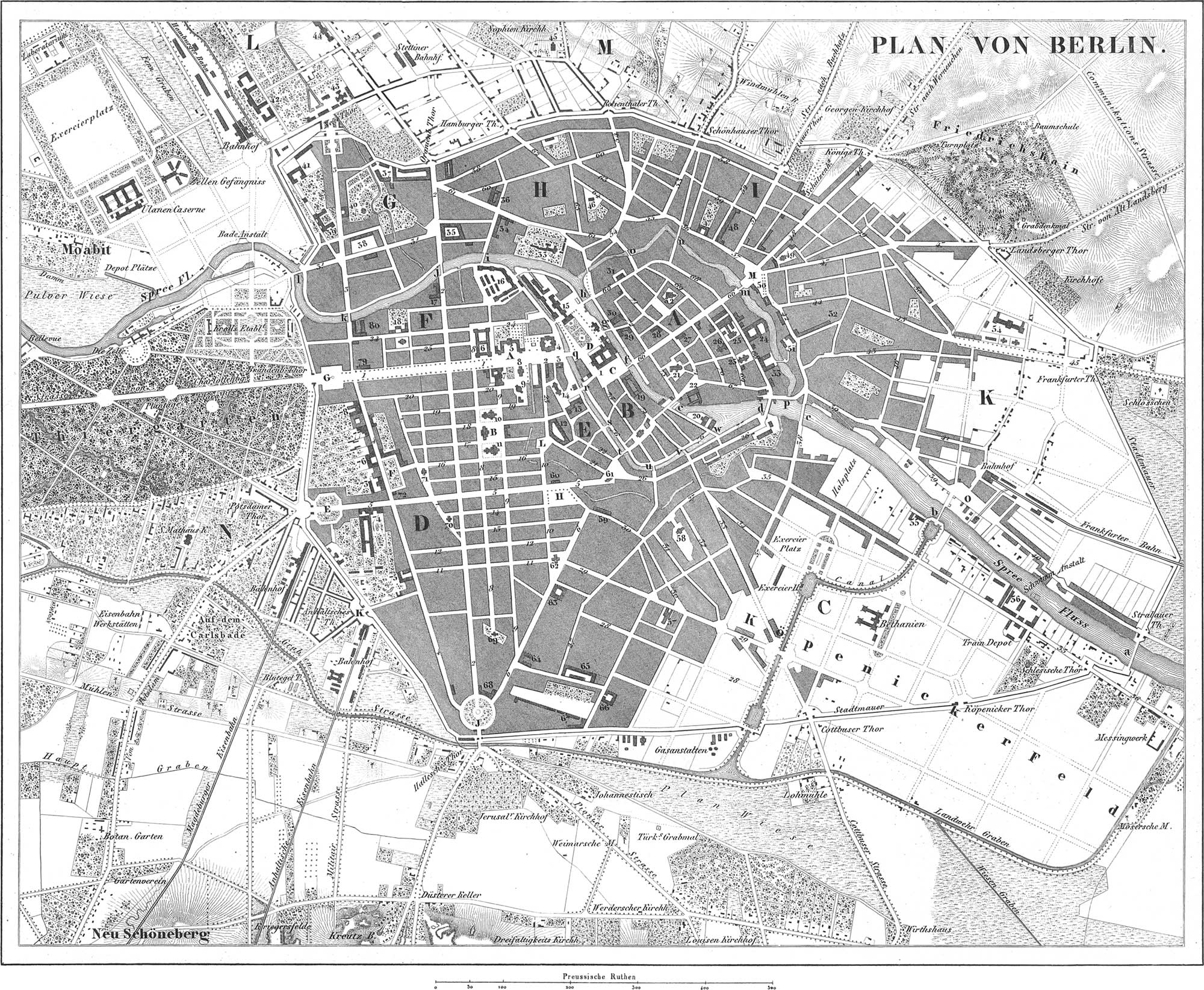
Berlin, the first city of the Prussian Monarchy, lies in the former Mark, and present Province of Brandenburg, in a perfectly level, sandy, and unattractive region, on the Spree. Its present population is 400,000, amongst which are 7000 Jews, 5–6000 Roman Catholics, 5500 French Reformed, 850 Bohemian Protestants, and the rest Evangelical. It is incontestably one of the most beautifully built cities in Europe, and, in its newer quarters, has a large number of superb edifices. It is divided into the following six parts: Berlin Proper or Old Berlin, Old and New Cologne (the oldest parts of the city), Friedrichstadt, Friedrichswerder, Dorothea- or Neustadt, Friedrich-Wilhems-stadt; to these must be added the Königsstadt, the Spandau and Stralau quarters, together with the Oranienburg, the Rosenthal, the Potsdam, and the Köpenick Suburbs (the latter now Louisenstadt). The Friedrichs- and the Neustadt are especially distinguished by broad and perfectly straight streets. The most conspicuous are the Linden, with a fourfold avenue of lindens, 2000 paces long and 160 feet broad; the Friedrichsstrasse, 8250 paces long; Königsstrasse, 2170 paces; Wilhelmsstrasse, 4650 paces; the Leipzigerstrasse, and the new Friedrichs-strasse. The most beautiful squares are the Paris square, Wilhelmsplatz, with six Marble Statues of Prussian Generals of the Seven Years’ war; the Belle Alliance Platz, with a column supporting a Victory, in commemoration of the twenty-five years’ peace of 1840; the Lustgarten; the square in front of the Arsenal; the Opera square, with the statues of Bliicher, Scharnhorst, and Biilow; the Gendarmen Mark, 440 paces long; the Donhof, the Leipzig, and the Schlossplatz. Among the gates, the Brandenburg Gate, at the end of the Linden, deserves especial mention; it consists of twelve Corinthian columns of forty-four feet in height and five in diameter; it is 195 feet broad, 64 feet high, and built after the model of the Propylaea at Athens; upon it stands the celebrated four span of horses with the Victoria. Of the forty bridges across the Spree (among them six of iron and eighteen of stone), the most conspicuous are the Long Bridge, with the bronze equestrian statue of the great Elector; and the new Palace Bridge. Of the thirty-three churches, none deserve especial notice; the most beautiful are the recently restored Convent Church, and the new Friedrichswerder Church; in the place of the old unsightly Cathedral, built in 1748, a much larger is to be erected, surrounded by a Campo Santo, containing the burial-place of the Royal House, and decorated with frescoes by Cornelius. The most conspicuous pubhc buildings are the King’s Palace, 460 feet long, with four courts, 500 chambers, and a beautiful dome; the Arsenal, 280 feet long; the Opera House; the Royal Library (containing over 250,000 volumes, and 4600 manuscripts); the University Building; the. Museum of Art and Antiquity (in a former bed of the river, placed on 8000 piles), a quadrangle 276 feet long, 179 feet deep, to which has been recently added a second Museum (not yet completed); the Mint; the Architects’ School; the Royal Guard House; the building of the Academy of Sciences; the Theatre; the new Royal Veterinary School, &c. In the vicinity of Berlin the Thiergarten is a very favorite and exceedingly beautiful promenade; in this, a monument to Friedrich Wilhelm III. has been recently erected. Another remarkable monument of cast iron, in commemoration of the struggle of 1813 to 1815, presents itself on the Kreuzberg before the Halle Gate.
Explanation of the Plan.
Divisions of the City.
- Berlin Proper or Old Berlin.
- Old and New Cologne.
- Louisenstadt, formerly Köpenicker Vorstadt.
- Friedrichsstadt.
- Friedrichswerder.
- Dorothea, or Neustadt.
- Friedrich-Wilhelm’s Stadt.
- Spandau Quarter.
- Königsstadt.
- Stralau Quarter.
- Oranienburger Vorstadt (Voigtland).
- Rosenthaler Vorstadt (Neuvoigtland).
- Potsdamer or Friedrichsvorstadt.
Public Squares (Plätze).
- Opernplatz.
- Gendarmenmarkt, with the Royal Theatre.
- Schlossplatz.
- Lustgarten.
- Leipziger Platz.
- Wilhelms Platz.
- Pariser Platz.
- Dönhof Platz.
- Belle Alliance Platz.
- Ascasnischer Platz.
- Hausvoigtei Platz.
- Alexander Platz.
- New Market.
- Stralau Platz.
Public Buildings.
- Royal Palace.
- King’s private Palace.
- Military Government Hall.
- Arsenal.
- University.
- Royal Academy.
- Library, and Palace of the Prince of Prussia.
- Royal Opera House.
- St. Hedwig’s Church.
- French Reformed Church.
- Cathedral.
- Police Prison.
- Royal Mint.
- Werder Church.
- Royal Museum.
- Artillery Barracks.
- Frederick William’s Institute.
- Grand Lodge; opposite St. Dorothea Church.
- Royal Stables.
- Warehouse-, and Island-Buildings
- St. Nicholas Church.
- Civil Government Hall.
- Parish Church.
- Royal Cadet House.
- Convent Church.
- French Church.
- City Hall.
- General Post Office.
- Military School.
- Joachimsthal Gymnasium: School.
- Garrison Church.
- St. Mary’s Church.
- Monbijou Palace.
- New Post Office.
- Barracks of the 2d Regiment of Guards.
- Old Post Office.
- Stables of the Mounted Artillery Guard.
- Barracks of the Infantry Guard.
- Old Charite (hospital).
- Veterinary School.
- New Charite (hospital).
- Hospital of the Invalids.
- Royal Iron Foundry.
- House of Artillery Practice.
- St. Elizabeth Church.
- St. Sophia Church.
- Royal Lithographic Institute.
- Barracks of the Regiment of Emperor Alexander.
- St. George Church.
- Königsstadt Theatre.
- Barracks of the Regiment Emperor Francis.
- Forage Magazine.
- Provision Magazine.
- Frederick William Hospital.
- Royal Salt Warehouse.
- Barracks of the Pioneer and Guard Sharp Shooters.
- St. Jacob’s Church.
- St. Sebastian Church.
- Barracks of the Regiment Emperor Francis.
- Chancery of State.
- Hospital Church.
- Jerusalem Church.
- Military Prison.
- Court of Justice.
- Barracks and Stables of the Dragoons of the Guard.
- Barracks and Stables of the Dragoons of the Guard.
- Barracks of the Cuirassier Guards.
- Barracks of the Hulan Guards.
- Observatory.
- Bohemian Church.
- Trinity Church.
- Foreign Department.
- Department of the Royal House.
- War Department.
- Palace of Prince Albert.
- Palace of Prince Radziwil.
- Ministry of Justice.
- Prince Frederick’s Palace.
- Artillery School and Police Office.
- Artillery Workshops.
Bridges (Brücken).
- Oberbaum.
- Schilling’s Bridge.
- Jannovitz Bridge.
- Waisen Bridge.
- Fischer Bridge.
- Long Bridge.
- Cavalry Bridge.
- New Fredericks Bridge.
- Eberts Bridge.
- Weidendammer Bridge.
- Marschall’s Bridge.
- Unterbaum Bridge.
- König’s Bridge.
- Kunowski Bridge.
- Spandau Bridge.
- Stralau Bridge.
- Schloss Bridge (large).
- Schloss Bridge (small).
- Jungfern Bridge.
- Gertrauden Bridge.
- Grünstrassen Bridge.
- Rossstrassen Bridge.
- Island Bridge.
Streets (Strassen).
- Unter den Linden.
- Friedrich’s Strasse.
- Louisen Strasse.
- 2 Karls Strasse.
- Wilhelm Strasse.
- Leipziger Strasse.
- Linden Strasse.
- Mauer Strasse.
- Charlotten Strasse.
- Markgrafen Strasse.
- Jerusalemer Strasse.
- Koch Strasse.
- Zimnier Strasse.
- Schützen Strasse.
- Krausen Strasse.
- Kronen Strasse.
- Mohren Strasse.
- Tauben Strasse.
- Jäger Strasse.
- Französische Strasse.
- Behren Strasse.
- Niederwall Strasse.
- Kur Strasse.
- Oberwall Strasse.
- Dorotheen Strasse.
- Mittel Strasse.
- Wall Strasse.
- Alte Jacobs Strasse.
- Ritter Strasse.
- Orangen Strasse.
- Commandanten Strasse.
- Stallschreiber Strasse.
- Sebastians Strasse.
- Dresdener Strasse.
- Schäfergasse (alley).
- Köpeniker Strasse.
- Schlesische Strasse.
- Neander Strasse.
- Brücken Strasse.
- Holzmarkt Strasse.
- Mühlen Strasse.
- Lange Gasse (alley).
- Alexander Strasse.
- Blumen Strasse.
- Kaiser Strasse.
- Grosse Frankfurter Strasse.
- Rosengasse.
- Landsberger Strasse.
- Neue Königs Strasse.
- Golnowsgasse.
- Weber Strasse.
- Prenzlauer Strasse.
- Kleine Alexander Strasse.
- Alte Schönhauser Strasse.
- Rosenthaler Strasse.
- Neue Schonhauser Strasse.
- Münz Strasse.
- Alexander Strasse.
- Linien Strasse.
- Hirtengasse.
- August Strasse.
- Oranienburger Strasse.
- Kleine Hamburger Strasse.
- Gips Strasse.
- Sophien Strasse.
- Grosse Hamburger Strasse.
- Königs Strasse.
- Stralauer Strasse.
- Neue Friedrichs Strasse.
- Kloster Strasse.
- Juden Strasse.
- Spandauer Strasse.
- Heilige Geist Strasse.
- Post Strasse.
- Breite Strasse.
- Brüder Strasse.
- An der Friedrichsgracht.
- Neu-Colln on the Water.
Vienna

Vienna, or Wien, the beautiful and lively capital of Austria, is situated at the foot of the Wiener Mountain, on the right bank of the Danube, which is here divided into three arms, and also on a canal, and on the Wien. With its suburbs it is about sixteen miles in circumference, and includes 9000 houses, with 410,000 inhabitants (not counting the military). Of these, about 12,000 are Protestants, and 600 Greeks. The inner city, or city proper, which forms only the tenth part of the whole, is separated from the thirty-four suburbs by the Esplanade or glacis, a surface 600 paces broad intersected by meadow lands and avenues, which occupies the place of the former fortifications: a further separation is effected by ramparts forty to sixty feet high, with eleven bastions (the latter partly changed into public gardens and promenades). All the suburbs, however, lie within the line, a wall twelve feet high and 42,500 feet long. Although the inner town (with 12 gates, 127 streets, 19 squares, 1300 houses, and 64,000 inhabitants) is irregularly built, it has many beautiful buildings, and numerous palaces. The finest squares are: the Burg or Paradeplatz, 950 feet long; the Hof, 400 feet long, with a marble column and two fountains; the High Market, with a marble monument in the form of a temple, representing the nuptials of Joseph and Mary; the Franzensplatz, with a monument to Emperor Francis I.; the Grahen, a street 100 feet broad, with the Marble Trinity Column, 66 feet high; the Josephsplatz, with an equestrian statue of Emperor Joseph II., 33 feet high; the New Market, with a beautiful basin, and the Freiung, with the new fountain, ornamented by Schwanthaler’s allegorical representations of the four principal rivers. The principal buildings are: the Burg or imperial residence, 1200 feet long, with three courts, and containing in one hall, 240 feet long and 84 broad, the Imperial Library, with 360,000 volumes and 12,000 manuscripts; the great Imperial Cabinet of Natural History in 4 halls; also a collection of 300,000 engravings, antiquities, works of art, &c., 32,000 coins and medals, and the Treasury; the Riding School near the Burg; the Castle of Arch Duke Charles; the Hof kammer; the Bank; the War Department, and the University Buildings; and about thirty noteworthy private palaces. Of the fifty-six churches and chapels (among them only two Protestant and three Greek) are St. Stephen’s Church, 330 feet long, 216 broad, with a spire 432\(\frac{1}{2}\) feet high (containing a bell weighing 35,400 pounds), 38 marble altars, 31 windows, and many tombs, amongst them those of Prince Eugene of Savoy, and of Emperor Frederick III.; the Augustins’ Church, with the celebrated monument to the Grand Duchess Christina, by Canova; the Church of the Redemptorists at Maria-Stiegen, with a spire 180 feet high, ending in a calyx and surmounted by a cross; the Capucin Church, with the tombs of the imperial family; the Italian Church, and the Church of St Michael.
Of the suburbs, which are divided into eight police districts, the most beautiful are the Leopoldstadt and Josephstadt, as also the Jagerzeil and the Taborstrasse; the most extended, however, are the Wieden, with 33,000 inhabitants, the Landstrasse with 26,000, the Leopoldstadt with 23,000 the Schottenfeld with 21,000, and Gumpendorf with 13,000. The principal buildings of the suburbs are the Imperial stable, 600 feet long, capable of containing 400 horses; the Palace Belvedere, containing the valuable picture gallery, and in an adjoining building the Ambrase collection of armor and works of art of the middle ages; the two Liechtenstein Palaces, one of them with a rich gallery of paintings; the Esterhazy and the Auersperg Palaces; the Stahremberg Free-House, with 300 residences and 2200 inhabitants; the Medico-Chirurgical, the Engineer and the Nobles’ Academies; the Invalid Hospital for 800 men; the Polytechnic Institute; the Public Hospital, with 111 apartments and 2000 beds; the Cannon Foundry; the great steam Rolling Mill; the Porcelain Manufactory. The Church of St. Borromæus in the suburb Wieden, built in the Italian style, with domes, portals, paintings, and the monument of Collin, next to the Church of St. Stephen, is the most beautiful in Vienna.
The River Wien is spanned by two stone bridges, one plank, and one suspension bridge; also by one suspension and several simple wooden footpaths; over the Wiener Donau Canal are six bridges, among them three suspension bridges; over the Danube, which converts the Leopoldstadt into an island, are several wooden yoke bridges. The southern suburbs are provided with water by the aqueduct from Hiittendorf to Vienna, which feeds twelve wells, as also by the new Emperor Ferdinand’s aqueduct, which draws up the water of the Danube at Nursdorf, by means of seven steam engines; in addition to these sources of supply, there are forty Artesian wells in different parts of the city.
The principal promenades are: 1, the Imperial Garden, with a menagerie and hothouses 568 feet long, containing a conservatory 72 feet long; 2, the Prater and the Augarten in the Leopoldstadt; 3, the Volksgarten, with a temple containing a statue of Theseus, by Canova; 4, the Gardens of Princes Schwarzenberg and Liechtenstein.
Vienna has two railroad depots: one in the north, on the island of Leopoldstadt, not far from the Praterstern, from which the Emperor Ferdinand’s Northern Railroad takes its origin; and one in the south, not far from the Belvedere line, from which the roads go out to Gloggnitz and Bruck.
Explanation of the Plan.
Suburbs.
- Leopoldstadt.
- Landstrasse.
- Wieden.
- Mariahilf.
- Neubau.
- Josephstadt.
- Alsergrund.
- Rossau.
Squares and Gardens.
- St. Stephansplatz (with the Cathedral).
- The Hof.
- High Market.
- Jew’s Place.
- Freiung.
- Graben.
- Minoritenplatz.
- Neuer Paradeplatz.
- Josephplatz.
- Ballplatz
- Voksgarten.
- Hofgarten.
- Kirchenplatz.
- Swine Market.
- Botanical Garden.
- Fruit Market.
- Grain Market.
Bastions and Gates (Basteien u. Thore).
- Biberbastei.
- Rothe Bastei.
- Gonzaga Bastei.
- Fischerthor.
- Neue Thorbastei.
- Schottenbastei.
- Schottenthore.
- Mölker Bastei.
- Kaiser-Franzthor.
- Löwelbastei.
- Burgthor.
- Augustinerbastei.
- Kärnthnerthor.
- Wasserkunstbastei.
- Seilerstetterthor.
- Stubenthorbastei.
- Stubenthor.
- Dommikanerbastei.
- Hauptmauththor (Customhouse Gate).
Public Buildings.
- Imperial Burg.
- University.
- Arsenal.
- Archbishop’s Palace.
- Infantry Barracks.
- Mint Building.
- Court Opera House.
- House of Invalids.
- Custom House.
- Belvedere.
- 2 Schwarzenberg Palace.
- German Nobleguards.
- Foundry.
- Theresianum.
- Freehouse.
- Imperial Stables.
- St. Charles Church.
- Polytechnic Institute.
- Barracks.
- Theatre on the Wien.
- Italian Nobleguards.
- Hungarian Nobleguards.
- Criminal Court.
- Public Hospital.
- Military Hospital.
- Insane Asylum.
- Asylum.
- Porcelain Manufactory.
- Orphan Asylum.
Streets (Strassen) and Alleys (Gassen).
- Herren Gasse.
- Augstiner Gasse.
- Kärnthner Strasse.
- Singer Strasse.
- Lichtensteg.
- Wipplinger Strasse.
- Hohe Brücke.
- Renn Gasse.
- Wallner.
- Jägerzeile.
- Prater Strasse.
- Tabor Strasse.
- Zur Franzensbrücke.
- On the Tabor.
- Herren Gasse.
- Lilienbrunn Strasse.
- Neue Strasse.
- Donau Strasse.
- Augarten Strasse.
- Prater Strasse.
- From Augarten.
- On the Glacis.
- Land Strasse, Haupt Strasse.
- Halter Gasse.
- Erdberg Gasse.
- Ritter Gasse.
- Anton Gasse.
- Raben Gasse.
- Waag Gasse.
- Paulus Gund, Haupt Strasse.
- Ungar Gasse.
- Renntrog Gasse.
- Feld Gasse.
- St. Pauli Höhe.
- Paulus Grund.
- Kirchen Gasse.
- Stern Gasse.
- Gärtner Gasse.
- Weissgerber Haupt Strasse.
- Lower Garten Gasse.
- On the Gestätte.
- On the Danube.
- Renntrog Gasse.
- Fasan Gasse.
- Heu Gasse.
- Favoriten Linien Strasse.
- Weiringer Gasse.
- Linien Gasse.
- Blechernes Thurmfeld.
- Meyerhöfel Gasse.
- Old Wiedner Haupt Strasse.
- Matzleinsdorfer Haupt Strasse.
- Mittersteig.
- Sieben Brunnen Gasse.
- Sieben Brunnen Meadow.
- New Wiedner Haupt Strasse.
- Gries Gasse.
- Margarethen Lange Gasse.
- Lange Gasse.
- Hundsthurmer Linien Gasse.
- Schloss Gasse.
- Ziegelofen Gasse.
- Kugel Gasse.
- Reinprechtsdorfer Strasse.
- Grosse Neue Gasse.
- Trappel Gasse.
- Penzinger Strasse.
- Mariahilfer Haupt Strasse.
- Leimgrube.
- Roth Gasse.
- Drei Hufeisen Gasse.
- On the Wein.
- Schleifmühl Gasse.
- Gumpendorfer Haupt Strasse.
- Windmühl Gasse.
- Gross Stein Gasse.
- Stumper Gasse.
- Müller Gasse.
- Linien Gasse.
- Zwerg Gasse.
- Schmalzhof Gasse.
- Grosse Schmiede Gasse.
- Schwaben Gasse.
- Sieben Stern Gasse.
- Kleine Stift Gasse.
- Spittelberg.
- Burg Gasse.
- Wendelstatdt.
- Lang Keller Gasse.
- Ritter Gasse.
- Kandel Gasse.
- Kirchen Gasse.
- Lamm Gasse.
- Fuhrmann’s Gasse.
- Feld Gasse.
- Ziegler Gasse.
- Neubau Gasse.
- On the Platzl.
- Neustift.
- Stadt Gasse.
- Kaiser Strasse.
- Roverani Gasse.
- Lerchenfelder Haupt Strasse.
- Lerchenfelder Strasse.
- Kosephstädter Kaiser Gasse.
- Lange Gasse.
- On the Glacis.
- Strozzische Grund Haupt Strasse.
- Neu Gasse.
- Allee Gasse.
- Benno Gasse.
- Albert Gasse.
- Feld Gasse.
- Alser Haupt Strasse.
- Magazin Gasse.
- Floriani Gasse.
- Herren Gasse.
- Piaristen Gasse.
- Neue Schotten Gasse.
- On the Burg Strasse.
- On the Alsterbach.
- Spital Gasse.
- Währinger Gasse.
- Fuhrmanns Gasse.
- Lange Gasse.
- Drei Mohren Gasse.
- Schmied Gasse.
- Bramer Gasse.
- Juden Gasse.
- Porzellan Gasse.
- Hauptplatz.
- Gestätten Gasse.
- Nussdorfer Haupt Strasse.
- Lichtenthaler Haupt Strasse.
- Kirchen Gasse.
- Grosse Kirchen Gasse.
- Schimmel Gasse.

Lisbon Plate 40
Lisbon, or Lisboa, the capital of the kingdom of Portugal, is situated on the Tagus, being extended for about five miles along its bank. It includes a population of about 280,000 souls, amongst which are a goodly number of negroes and mulattoes. In point of beauty of situation it competes with Naples, Constantinople, Genoa, and Stockholm. It has neither walls nor gates, but incloses three hills, as also numerous gardens, and even some fields. The north and east quarters of the town are irregularly built, and contain mostly narrow, crooked, and in part steep, streets. On the other hand, however, the New City, built up since the great earthquake of 1755, is equally conspicuous for its regularity and beauty. Here we find three great squares: the Praza do Comercio, or Trade Market, 600 feet long, adorned, in addition to the brazen equestrian statue of Joseph I., by a number of splendid buildings, such as Library, Exchange, Custom House, Government Buildings, Arsenal, India House, &c.; also the Rocio, 1800 feet long, and the Praza do Figueira or Fruit Market, planted with trees and filled with booths; the Praza do Polerim, &c. In addition to the buildings already named, there are the Opera House, City Hall, Arsenal, the College of the Nobility, the Corn Hall, the Cannon Foundry, the Prison (Limoeiro), the Treasury, &c. The numerous churches are neither large nor beautiful, although generally adorned to a great extent internally; the Patriarchal Church, by its elevation on a hill, towers above all the rest, and the Church of St. Rochus is worthy of note, on account of its splendid chapel built by John V. The Royal Palace lies in the hamlet of Belem, now embraced within the city. A masterpiece of architecture is seen in the marble aqueduct, built by John V., which supplies the city with water; it consists of thirty-five arches, which carry the water for 2400 feet across the valley of Alcantara: the highest of these arches is over 230 feet in elevation. The city itself is without fortifications; a remnant of antiquity is met with in the Moorish Castle on the highest hill in the city, in which are kept the Archives, and a House of Correction. The extensive and safe harbor is protected by several forts: Fort St. Juliao, Torre do Buzio, Belem, and St. Sebastiao.
Explanation of the Plan.
Squares.
- Prâça (square) Alcantara
- Prâça (square) Amorciras.
- Prâça (square) Rato.
- Prâça (square) Romulares.
- Prâça (square) Rocio.
- Prâça (square) Allegria.
- Largo Passiâo Publico.
- Prâça S. Domingo.
- Largo Carmo.
- Prâça Figueira.
- Paço da Ranha.
- Prâça or Campo de Santa Clara.
- Largo S. Vincente.
- Prâça Pelourinno.
- Prâça das Flores.
- Largo do Convento da Graça.
- Largo do Socorro.
- Largo do Outeirinho.
- Porta do Sol.
- Largo do Loretto.
- Largo Quintella.
- Prâça do Comercio.
- Public Promenade (Passeio publico).
- Largo Conde Barâo.
- Square in front of the Castle and Convent of Santa Cruz.
Streets (Ruas).
- Rua Augusta.
- Rua da Magdalena.
- Rua nova del Ray.
- Rua Santa Julia.
- Rua da Conseicâo.
- Traversa de San Nicolao.
- Traversa da Victoria.
- Traversa da Assumpçao.
- Traversa de Santa Justa.
- Rua dos Martyres.
- Rua das Flores Largo.
- Rua de San Paulo.
- Rua da Boa Vista.
- do Marquez de Abrantes.
- Rua de S. Francisco de Paula.
- Rua do Sacramento.
- Rua do Livramento.
- Rua de Buenos-Ayres.
- Calçado do Estralla.
- Rua do Quelhas.
- Rua da Esperança.
- Rua do Poes Negros.
- Rua de San Bento.
- Largo do Calhariz.
- Rua do Monho de Vento.
- Rua da Salitre.
- Rua de Santa martha.
- Careira dos Cavallos.
- Rua do Sol Rato.
- Costa do Castello.
Public Buildings.
- Palacioi (Palace) de Nostra Sennora Necessidades.
- Old Fort on the Tagus.
- Armarens do Polvora.
- Convento et Igregia (Convent and Church) dos Barb. da Bo Morte.
- Convento do Caraçâo de Jesus.
- Convento da Estrella.
- Convento S. Isabel.
- Convento de S. Bento.
- Convento dos Inglezinhos.
- Convento da Esperança.
- Convento dos Paulistes.
- Convento de Jesus.
- Collegio des Inglezes (of the English).
- Convento et Igregia da Trinidade.
- Convento et Igregia do Carmo.
- Convento et Igregia Cara da Misericordia.
- Palacio da Inquisizione.
- Convento et Igregio de S. Francisco.
- Church San Roque.
- Church San Loretto.
- Church San Paulo.
- Alfandega et Aduana (Custom House).
- Convento da Graça.
- Nostra Sennora do Monte.
- Convento S. Vicente de Fora.
- Convento do Santa Clara.
- Funiçao de Baixo.
- Palacio Bemposta.
- Igregia do Coroçao de Jesus.
- Convento S. Antonio dos Capuchos.
- Convento dos Desterro.
- Collegio dos Nobres.
Naples Plate 40
Naples, or Napoli, the capital city of the kingdom of the Two Sicilies, is celebrated for its beautiful situation on a magnificent bay, encircled by the Capes Miseno and Campanella, and the islands of Capri, Ischia, and Procida. The city, with its population of 370,000 inhabitants, is one of the largest, and at the same time one of the most beautiful in Europe. It is indeed true, that the streets are generally only from six to eight paces wide, and that the houses are very high, having sometimes as many as eight stories, but some streets are conspicuously broad and regular; amongst these, the street Toledo is the most important, as well as the liveliest. Some of the principal points and squares in the city are: the Chiaja, a fine street along the sea, with the Villa Reale, a royal pleasure castle; the squares Largo di Castello, Largo dello Spirito Santo, with the equestrian statue of Charles III.; the Piazza di Santa Lucia, and the Market Place, termed Largo del Mercato. The principal buildings are the Royal Palace, adjoining the Arsenal and Castel Nuovo on the great harbor; the Palace Capo di Monte on a mountain before the city, with Observatory and Library; the Finance Palace; the Archbishop’s Palace; the great Grain Magazine; the great Poor House, and the Theatre San Carlo, the largest in Italy, with six tiers of boxes. Amongst the churches and chapels, over two hundred in number, may be mentioned the Church of St. Francis of Paula, although many others are more or less eminent for their interior decoration, antiquity, paintings, sculpture, &c. Among the collections of science and art, is the Museo Borbonico, in the Palace degli Studi, consisting of a rich gallery of paintings in eight halls, and a still richer collection of antiques. Six castles protect and command the city; among them, Castel St. Elmo, in the highest part of the city, connected by a bridge with the Castel Pizzo Falcone; Castel Nuovo, the former royal residence, now containing an artillery school; the Castello dell’ Uovo on an island in the harbor, connected with the main land by a bridge; and the Castello Capuano, which likewise served as a royal residence for a time, and now contains the Supreme Court of Justice.
Explanation of the Plan.
Public Squares and Gates.
- Porta di Constantinopoli.
- Porta Medina.
- Porta Suscella.
- Porta di San Gennaro.
- Largo delle Pigne.
- Largo de’ Miracoli.
- Piazza de Tribunali.
- Largo fuori la Porta Capuana.
- Largo Ponte della Maddalena.
- Piazza del Marcato.
- Piazza del Real Palazzo.
- Largo del Castello.
- Largo Santa Maria a Capella.
- Largo del Vasto.
- Largo dello Spirito Santo.
- Piazza del Gesù Nuovo.
- Largo di S. Domenico.
- Largo della Carità.
- Largo della Vittoria.
Streets.
- Strada Nuova di Capo di Monte.
- Strata arena della Sanita.
- Strata de’ Cristallini.
- Strata delle Vergini.
- Strata Foria.
- ′ Strata S. Carlo air Arena.
- Fossi di Ponte nuovo.
- Strada del Borgo di S. Antonio Abbate.
- Strada Carbonara.
- Strada dell’ Orticello.
- ′i′. Strada di Tribunali.
- Strada S. M. Constantinopoli.
- Strada l’Anticaglia.
- Strada Trinità maggiore.
- Strada Nolana.
- Sellarie Pennino.
- Strada Borgo di Loretto.
- Strada Nuova.
- Molo Piccolo.
- Posta Strada di Porto.
- Strada Lanzieri.
- Strada Medina.
- Strada San Carlo.
- Strada Montoliveto.
- Strada Santa Anna de’ Lombardi.
- Calata Trinita maggiore.
- Strada Lucia.
- Strada del Gigante.
- Strada Toledo.
- Strada S. Teresa.
- Strada Mater Dei.
- Salita Gonfalone.
- Strada della Salute.
- Strada dell’ Infrascata.
- Strada Monte Santo.
- Strada de’ Sette dolori.
- Strada S. Polito.
- Strada di Chiaja.
- Chiaja.
- Strada Monte di Dio.
- Salita del Vomero.
- Strada di Piedigrotta.
- Strada Santa Catterina.
- Strada S. Teresa.
Puhlic Buildings.
- Palazza del Rè.
- Palazza Vecchio.
- Teatro San Carlo.
- San Francesco di Paola.
- Palazzo Francavilla.
- L’Ascensione a Chiaja.
- Pizzofalcone et Tipografia Reale
- Quartiere (Barracks).
- Ministeri di Stato.
- Ufficio della Posta.
- Posta.
- Dogana.
- Banco delle due Sicilie.
- Teatro Nuovo.
- S. Pietro Martire.
- Ospedali la Trinita.
- San Martino.
- Bagni.
- Chiesa del Carmine.
- S. Agostino della Zecca.
- Vullo deir Annunciata.
- Palazzo Tribunali.
- S. Marcellino.
- Università.
- Santa Chiara.
- S. Domenico maggiore.
- Banco dello Spiritu Santo.
- San Paolo.
- Duomo.
- Incurabile Ospedal.
- Collegio de’ Med. et de’ Chirurg
- Museo Borbonico.
- Sacramento Ospedal.
- San Giovanni a Carbonara.
- Reale Collegio de’ Miracoli.
- Villa Marchese Tomasi.
- San Gennaro o le Catacombe.
- Reclusorio (House of Correction).

Rome Plate 41
This ancient city, once the capital of the most powerful nation on the earth, and now the capital city of the States of the Church, is situated on the Tiber, about fourteen miles from where it discharges into the sea. It is fourteen to twenty miles in circumference, and has a population of about 160,000, amongst which are over 6000 ecclesiastics, monks, and nuns, and about 4000 Jews. Its walls still inclose the seven ancient hills, the Palatine, Capitoline, Quirinal, Coelian, Aventine, Viminal, and Esquiline. The principal of the public squares are: the Capitol Square, with the gilt equestrian statue of Marcus Aurelius, and the statues of Castor and Pollux, together with the Palace of the Senate, the Capitoline Museum, and the Palace dei Conservatori; 2, the Piazza (square) del Popolo, with the beautiful churches de’ Miracoli and di Monte Santo, as also with an Egyptian obelisk eighty-two feet high; 3, Piazza Colonna, with the column of Antonine, and the Palaces Chigi and Spada; 4, the Piazza del Monte Citorio, with the obelisk of the Sun and the Palace of Justice; 5, the Piazza di S. Pietro, in front of St. Peter’s, with the Custom House; 6, the Piazza Rotonda, with the Pantheon; 7, the Piazza Navona, an ancient circus, with the Church of St. Agnes, and three fountains; 8, the Piazza della Trinita del Monte; 9, the Piazza di Monte Cavallo, with the palace of the Pope (Quirinal), two antique horses, and the Palace della Consulta. The ancient Forum is now covered to a depth of thirty feet with rubbish, and is called Campo Vaccino (Cowmarket). Rome’s three principal streets are the Corso, a straight line for 2700 paces, the Via Ripetta, and the Via Babbuina. Among the 341 churches and chapels, stands pre-eminent the celebrated St. Peter’s, 640 feet long, 470 feet broad in the cross, 408 feet high in the spire, and with a dome 220 feet high in the interior, with twenty-nine altars and innumerable statues; a still more gorgeous church, although of less size, is that of St. John in the Lateran, with 335 columns, the Parish Church of the Pope, and the principal church of Catholic Christianity; other churches are St. Mary’s Church, or the ancient Pantheon; the Church of Sta. Maria Maggiore, with 40 columns of granite and marble; Trinita del Monte, with a beautiful flight of steps; Santa Maria, in Trastevere, the oldest church in Rome, &c. Among the palaces may be mentioned: the Vatican, connected with the Castle of St. Angelo by a covered way; it is 1200 feet long, 1000 feet broad, with twenty-two courts, and several thousand chambers, containing countless treasures of books, manuscripts, records, antiquities, and works of art; the Quirinal, residence of the Pope; the Palaces Pamfili, Barberini, Aldobrandini, Spada, Colonna, Borghese, Caffarelli, Braschi, Orsini, Corsini, Farnese, &c., all remarkable for their size, architecture, or collections of art. Of the innumerable ruins, from the times of the ancient Romans, some of the principal are: the Coliseum or Amphitheatre of Titus, 560 feet long, 472 broad, 154 high, capable of seating 80,000 persons; the Column of Trajan, 141 feet high, 12 feet thick, composed of 34 blocks of marble; the marble column of Antonine, 117 feet high; eleven obelisks (the largest 115 feet high, 9 feet thick, of red granite); the aqueducts, of which three still supply the city with water; the Baths of Caracalla, Diocletian, and Titus; the Pyramid of Cestius, 126 feet high (with the Protestant burying-ground in front). The subterranean passages called Catacombs, and extending to a great distance under ground, are very interesting; originally stone quarries, they were subsequently used as burial-places and places of worship. Rome has numerous beautiful fountains, the finest of which are the Fontana Trevi or Vergine, Fontana di Tritone, Fontana dell’ Acqua Felice, and the spring on the Piazza Navona. Among the educational institutions are the University and the Collegio Romano, with an observatory and a botanic garden. The chief among charitable institutions are the immense Hospital of the Holy Ghost, and the Hospital of St. Michael, for 230 old men, 100 women, 480 boys, and 520 girls.
Explanation of the Plan.
- Piazza di S. Pietro.
- Piazza del Popolo.
- Piazza Navona.
- Piazza de’ Capucini.
- Piazza degli Apostoli.
- Piazza de’ Termini.
- Piazza della Trinità de’ Monti.
- Mausoleo di Adriano.
- Ruins of the Vatican Bridge.
- Ospedale di Santo Spirito.
- Piazza di Santa Marta.
- Covered way from the Vatican to the Castle of St. Angelo.
- Palazzo Farnese.
- Piazza di San Francesco.
- Ospizio di S. Michele.
- Arsenale.
- Ospedale di San Giacomo.
- Mausoleo di Augusto.
- Teatro Aliberti.
- Piazza di Spagna.
- Piazza Mignanelli.
- Piazza Nicosia.
- Piazza Silvestro.
- Piazza Barberini.
- House of Sallust and Temple of Venus.
- Piazza di Ponte.
- Teatro Tordinone.
- Monte Giordano.
- Piazza Sforza.
- Care ere.
- Statua di Pasquino.
- Cancelleria.
- Sapienza.
- Teatro della Valle.
- Chiesa di S. Eustachio.
- Panteon.
- Collegio Romano.
- Piazza della Minerva.
- Dogana.
- Monte Citorio.
- Teatro Capranica.
- Piazza Colonna.
- Fontana di Trevi.
- Piazza della Pilotta.
- Piazza di Monte Cavallo.
- Palazzo Pontefico.
- Piazza di Venezia.
- Giardino Colonna.
- Reservoir of the Baths of Diodetian.
- Aqueduct.
- Basilica de Santa Maria Maggiore.
- Terme (Bagni) di Paolo Emilio.
- Colonna e Basilica del Foro Trajano.
- Palazzo Farnese.
- Piazza Farnese.
- Teatro di Pompejo.
- Teatro Argentina.
- Piazza Cenci.
- Piazza Giudea.
- Teatro di Marcello.
- Rocca Tarpea.
- Campidoglio.
- Campo Vaccino.
- Cloaca Maxima.
- Forum Boarium.
- Ruins of the Palaces of the Cæsars.
- Reservoirs of the Baths of Titus.
- Trofei di Mario.
- Mausoleo di Mario.
- Tempio di Minerva Medica.
- Anfiteatro Castrense.
- Basilica di S. Giovanni in Laterano.
- Ospedale.
- Chiesa di S. Stefano Rotondo.
- Piazza di S. Gregorio.
- Ponte Sublicio.
- Ponte Rotto.
- Terme di Tito.
- Coliseo.
- Chiesa di S. Giovanni e Paolo.
- Isola S. Bartolomeo.
- Ponte Sisto.
- Ponte S. Angelo.
- Via della Lungara.
- Via della Lungaretta.
- Via de’ Genovesi.
- Via de’ Morticelli.
- Via di S. Francesco.
- Via di S. Michele.
- Via dell Fratte.
- Borgo Vittoria.
- Borgo Pio.
- Borgo Nuovo.
- Borgo Vecchio.
- Borgo S. spirito.
- Via di Ripetta.
- Via del Corso.
- Via Babbuina.
- Via della Fontanella.
- Via de’ Condotti.
- Via Sistina.
- Via Felice.
- Via delle quattro Fontane.
- Via di Porta Pia.
- Via della Vita.
- Via delle Mercede.
- Via Tordionona.
- Via dell’ Orso.
- ′ Via di’ Coronari.
- ′ Via di’ Banchi.
- ′ Via di Monserrato.
- ′ Via Giulia.
- ′ Via del Fontanone.
- ′ Via del Pelegrino.
- ′ Via del Governo Vecchio.
- ′ Via di’ Giubbonari.
- ′ Via del Pianto.
- ′ Via del Cesarini.
- ′ Via del Gesù.
- ′ Via di Arceli.
- ′ Via Arco de’ Pantani.
- ′ Via Baccina.
- ′ Via del Coliseo.
- ′ Via de’ Serpenti.
- ′ Via del Boschetto.
- ′ Via delle Carette.
- ′ Via di S. Lorenzo in Pane e Perna.
- ′ Via Urbana.
- ′ Via Graziosa.
- ′ Via di S. Pudenziana.
- ′ Via di S. Maria Maggiore.
- ′ Via Paolo.
- ′ Via di S. Lucia in Selci.
- ″ Via di S. Martino.
- ″ Via di S. Vito.
- ″ Via di Marmorata.
Milan Plate 41
Milan (in German, Mailand), the capital of the Lombardo-Venetian kingdom, although an ancient-looking, irregular city, still possesses some recently built palaces and churches, with many beautiful streets. The first rank amongst the public buildings is assumed by the celebrated Cathedral, 454 feet long, 275 broad, built entirely of white marble, and adorned, or rather overloaded, externally, with not less than 4000 statues; of the other seventy-eight churches, we may mention San Lorenzo, with antique marble columns, and Madonna presso San Celso; of the convents, the former Dominican Convent of Santa Maria delle Grazie, containing the renowned, but now almost entirely destroyed, fresco painting by Leonardo da Vinci, of the Last Supper; likewise the Palace della Corte, the Government Palace, the Palace of the Archbishop, the Mint, the Palace of the Court of Appeal, the Theatre della Scala, with 400 boxes, and capable of seating 7000 persons (in addition to which, Milan has six other theatres); the large hospital. The principal collections of art and science are: the Palace Brera, formerly belonging to the Jesuits, with a library, a gallery of antiques and paintings, a botanic garden, and an observatory: also, the celebrated Ambrosian Library, with 15,000 manuscripts, and a large cabinet of coins. There still remains to be mentioned the circus, built under Napoleon in the ancient style, and capable of seating 30,000 persons, with an arrangement for filling the arena with water: also the Marble Arch of Peace, commenced in 1807, by Napoleon, and completed in 1829; it is eighty-four feet high, forty-two broad, with eight marble columns forty-two feet high and two feet thick, and entirely covered with alto relievos. The most frequented promenade is the Corso. The place of a river is supplied by the Grand Naviglio Canal, commenced in 1271; it is nineteen miles long, and goes by the Abbiate Grosso into the Ticino.
Explanation of the Plan.
- Piazza del Duomo.
- Piazza dei Marcanti.
- Piazza del Palazzo Reale.
- Piazza Fontana.
- Piazza della Vetra.
- Piazza e Parochiadi S.Eustorgio.
- Foppone, ossia Camp Santo.
- Ponte di Porta Romana.
- Piazza e Parrochia di S. Marco.
- Collegio delle Vevode.
- Ospedale de’ Fatebene-Fratelli.
- Collegio de’ Nobili.
- San Bartolomeo.
- Tipografia Reale.
- Palazzo della Contabilità generale.
- S. Pietro Celestino.
- San Damiano.
- San Pietro in Gessate.
- Collegio Imp. delle Fanciulle.
- La Guastalla, Collegio.
- Ospedale di S. Catterina.
- Santa Maria del Pardiso.
- San Calimero.
- Orfanotrofio Milit. di s. Luca.
- La Vittoria.
- S. Calogero.
- S. Vittore al Carpo.
- S. Nicolo.
- Santa Maria del Castello.
- Broletto Delegaz. Provinz. e Municipale.
- Corte d’ Apello ed Ipoteca.
- S. Tomaso in Terra Mala.
- Uffizio de’ Tesi e Misure.
- Il Carmine, Parrochia.
- Palazzo dell’ Imper. Reale Commt. Militare.
- Palazzo di Brera, Accademia Reale.
- Ponte Marcellino.
- Posta de’ Cavalli.
- Monte de Pieta.
- S. Giuseppe.
- Amministrazione del Lotto.
- Real Teatro della Scala.
- Filodrammatici.
- Direzione generale di Polizia.
- Palazzo dei Marini e della Finanza.
- Uffizio della Diligenza.
- Monte.
- Seminario.
- Ponte di Porta Orientale.
- Ponte di San Damiano.
- Piazza e Palazzo Belgiojoso.
- Piazza e Parrochia S. Fedele.
- Uffizio generale del Censo.
- Teatro Rè.
- Archivio pubblico.
- Residenza de’ Tribunali Civili.
- Biblioteca Ambrosiana.
- Ponte di Porta Toaa.
- Luogo Pio Trivulzi.
- Palazzo di Giustizia.
- Palazzo Archivescovile.
- Palazzo Reale.
- Corte di Giustizia Correzionale.
- Ospedale Maggiore.
- Teatro della Conobbiana.
- Uffizio della Posta per le Lettere.
- S. Sepolcro e Piazza.
- Direzione generale del Demanio.
- S. M. Pedone e Piazza Borromea.
- S. Giorgio.
- S. Alessandro.
- Teatro del Lentasio.
- S. Eufemia e Piazza.
- Ponte di S. Celso.
- Ponte delle Pioppette.
- San Lorenzo.
- Ponte di Porta Ticinese.
- Ponte de’ Fabbri.
- Ospedale Milit. di S. Ambrogio.
- Ponte di S. Vittore.
- Caserma.
- Ponte di Porta Vercellina.
- Conservatorio di Musica e S. M. della Passione.
- Palazzo del Governo.
- S. Simpliciana e Caserma.
- Collegio Calchi.
- La Stella, Orfanotrofio.
- Ospedale di S. Antonio.
- Salesiane.
- Teatro Carcano.
- Stada di S. Teresa.
- Stada di S. Angelo.
- Stada Risara.
- Borgo di S. Angelo.
- Corso e Borgo di Porta Comasina.
- Strada de’ Fatebene-Fratelli.
- Contrada di Borgo nuovo.
- Contrada di Brera.
- Strada del Pontaccio.
- Contrada del Monte di Pieta.
- Contrada deir Olmetto.
- Corso di Porta nuova.
- Corsia del Giardino.
- Strada di S. P. Celestino.
- Strada di S. P. Damiano.
- Contrada di S. P. Romano.
- Contrada del Monte.
- Contrada di S. Paolo.
- Contrada del Marino.
- Corsia de’ Servi.
- Contrada S. Margherita.
- Contrada delle Meraviglie.
- Corso di Porta Vercellina.
- Borgo delle Grazie.
- Stradone di S. Vittore.
- ′ Strada del Ponte de’ Fabbri.
- ′ Strada della Vittoria.
- ′ Borgo di Viarenna.
- ′ Corso di Porta Ticinese.
- ′ Borgo di Cittadella.
- ′ Strada del Molino delle Armi.
- ′ Corso e Borgo di S. Celso.
- ′ Strada di S. Sofia.
- ′ Corso di Porta Romana.
- ′ Borgo di Porta Vigentina.
- ′ Strada dell’ Ospedale.
- ′ Contrada di S. Prassede.
- ′ Strada del Foppone.
- ′ Contrada dell’ Ospedale.
- ′ Contrada Larga.
- ′ Corso di Porta Tosa.
- ′ Contrada del Durino.
- ′ Contrada della Lupa.
- ′ Contrada di S. Orsola.
- ′ Contrada di S. Simone.
- ′ Contrada de’ Ratti.
- ′ Corsia del Duomo.
- ′ Corso di S. Vittore 40 Martiri.
- ′ Corso di S. Andrea.
- ′ Corso de’ Bastelli.
- ″ Corso di S. Giuseppe.
- ″ Corso de’ Filodrammatici.

Madrid Plate 42
Madrid, the capital city of Spain, with a population of 200,000, lies in a bare unattractive plain on the left bank of the Manzanares, about 2000 feet above the level of the sea, and is built on a number of small hills. The river at the city is crossed by two large stone bridges, one of them 1130 paces long. The city forms an irregular quadrangle, surrounded by a high brick wall, and is divided into two northern and two southern quarters. The old quarter to the south-west has mean houses and narrow streets; the new, much larger and more beautiful buildings, and broad straight streets; amongst which may be mentioned those of Alcala, San-Bernardo, Fuencarrel, and Toledo. The principal squares are the great market or Plaza Mayor, and the Plaza Puerto del Sol, the latter the centre of the city and the gathering place of the business people. Of the public buildings, we may mention the Castle Buen Retiro, or the ancient royal castle, on the east side of the city; the still unfinished new palace, 470 feet long, on the west side of the city; the large Ferdinando-Hospital, the City Hall, the Custom House, Post-Office, Arsenal, Mint, Court Prison, &c. Among the seventy-seven churches, conspicuous not on account of their architectural beauty, but for their excellent paintings, those deserving of especial notice are St. Isidore’s Chapel, the Church of the Salesian nuns, the Church of St. Isabella, and the Church of Antiochia; of the convents, the Franciscan Monastery, inclosing ten courts. The collections of art and science are very important; among them the Royal Library of 200,000 volumes, with a cabinet of 150,000 coins and medals; the Library of San Isidoro, of 50,000 volumes; the Royal Museum, with one of the finest collections of paintings in existence; the Royal Cabinet of Natural History, and the Observatory on the new castle. The Prado is the most beautiful public promenade; it extends between the Palace Buen Retiro and the city, adorned with four rows of trees, as also with fountains and statues. There is likewise the garden of Buen Retire close to the Prado, with the statues of Philip II. and Charles I. A large aqueduct conducts springs of water from the Guadarama Mountain into the city, which is there distributed in thirty-two wells.
Explanation of the Plan.
- Palacio del Rey.
- Real Biblioteca.
- Ministerios.
- Casa que fue de suprema Inquisicion.
- Casa del Duque del Parque.
- Quartel de Caballeria.
- Casa del Duque de Osuna.
- Quartel de las Guardias Corps.
- Seminario de los Nobles.
- Colegio de las Arrepentidas.]
- Monserrate, Monasterio Benitos.
- El Salvador.
- Santa Ana (Bernardos).
- El Rosario (Dominicos).
- Casa del Duque de Albuquerque.
- Hospital de los Franceses.
- Carmen Calzado, Convento.
- Quartel de las Guardias Españolas.
- El Hospicio, Colegio.
- Ninas de Leganes, Colegio.
- Aduana y Estanco general.
- Academia de las Nobles Artes.
- Carmelitas Descalzos, Convento.
- Las Salesas, Monasterio.
- San Pasqual, Franciscas.
- Casa del Duque de Medina Sidonia.
- Hta. de San Felipe Neri.
- Gustinos Recoletos.
- Real Casadi Moneda.
- Posito.
- Espiritu Santo.
- Buen Suceso, Hospital.
- Descalzados Reales, Franciscas.
- San Felipe Neri, Convento.
- Los Consjos.
- Plaza de la Villa.
- Casa del Duque de Infantado.
- San Audres, Parroqua.
- Casa del Duque de Alba.
- Casa del Conde de Fernando Nuñez.
- San Francisco, Convento y Campillo.
- Fabrica Real de Cristales.
- Orden Tercerca, Hospital.
- Matadero en la Puerta de Toledo.
- Carniceria del Rastro y Plaza Cerillo.
- La Latina, Hospital.
- San Isidorio y Real Colegio.
- Academia de la historia.
- Carcel de Corte.
- Santo Tomas, Dominicanos.
- Santa Cruz, Parroqua.
- San Felipe Real, Augustinos.
- Casa de Correos.
- La Magdalena y Casa del C. de Salvatierra.
- Trinitarios, Calza Convento.
- Casa del Duque de Alba.
- Fabrica de Aguardiente (Cigarros).
- Nuestra Seiiora de la Paz.
- Plaza y Fuente de Lavapies.
- San Lorenzo.
- Carcel de la Corona.
- Anton Martin, Hospital.
- Hospital de la Misericordia.
- Beatas de San Josef.
- Loretto Ninas, Colegio.
- Hospital grande para Hombres.
- Agonizantes, Hospital.
- Capuchinos del Prado, Convento.
- Trinitarios Descalzos.
- Cabineto de Historia Natural.
- 71. Quartel de Caballeria.
- Plaza del Coliseo.
- Plaza principal y Casa de los Proceres.
- Estudio y Jardin Botanico.
- Observatorio.
- Campo Santo.
- Estatua Equestre del Rey Felipe IV.
- La Leonera.
- Plaza de los Toros.
- Ermita de Nuestra Señora del Puerto.
- Passeo de la Florida.
- Santa Maria de la Pabera.
- Nuestra Senora de Atocha.
- Fabrica Real de Tapices.
Saragossa Plate 42
Saragossa, or Zaragoza, the capital of the Spanish province of Arragon, is situated in a fertile plain on the Ebro, over which stream is thrown a fine stone bridge, 600 feet in length. Below the city, the Huerba or Guerva empties into the Ebro, after having inclosed the south-eastern part of the city in a crescent. The population amounts to about 45,000. The streets, with but few exceptions, are narrow, crooked, and badly paved. One of the most prominent public buildings is the Church Nuestra Senora del Pilar, with an image of Mary on a column of jasper. The city is celebrated for its heroic defence under Palafox, against the besieging army of the French, from the 4th to the 14th of August, 1808, and a second time from December 20th, 1808, to Feb. 21, 1809, in which 60,000 persons perished by sword and famine. Under the Romans, this city was called Caesar Augusta, or Csesarea.
Explanation of the Plan.
- Convento de los Facetas.
- Santa Lucia.
- San Domingo.
- Santa Inès.
- Capuchinos Descalzos.
- Nuestra Senora del Portillo.
- Quartel de Caballeria.
- Circo para los Toros.
- La Miserieordia.
- Plaza de la Miserieordia.
- Convento de los Capuchinos.
- Hospital.
- La Encarnacion.
- Carmeletas Descalzos.
- Convento.
- Convento dela Vitoria.
- San Pablo.
- Calle del Merc ado nuevo.
- San Juan de los Panales.
- Nuestra Senora del Pilar.
- San Felipe.
- San Tomas.
- Convento de San Francisco.
- San Diego.
- Plaza del Carmen.
- Plaza Convento de Santa Engracia.
- Las Monjas de Jerusalem.
- Hospital de los Locos.
- El Asco.
- El Sepulcro.
- Compañia de Jesus.
- Universitad.
- San Augustin.
- Santa Monica.
- Plaza San Augustin.
- Convento de San Josef.
- Convento de San Lazaro.
- El Calzas de San Josef.
- Castillo de Aljaferia (de la Inquisicion).
Barcelona Plate 42
Barcelona, the capital of the Spanish Principality of Catalonia, one of the largest and most flourishing cities in Spain, is situated on the Mediterranean Sea, between the mouths of the Llobregat and Bezas. With the neighboring town, or rather suburb Barceloneta, it has over 10,000 houses, and about 150,000 inhabitants, of which 10,000 belong to the above-mentioned suburb. On the east side of the city is situated a strong citadel, which is connected with the Fort of San Carlos on the sea; on the west side rises up Montjuy, with a fort which commands the harbor. Among the principal buildings are the great Cathedral, the ancient castle of the former Counts of Barcelona, a large hospital for 3000 invalids, the Arsenal, the Cannon Foundry, &c. There still remain, from the time of the Romans, the ruins of a Temple of Hercules, and of some baths. The spacious, but not sufficiently deep harbor, is protected by an extensive mole, at the end of which is a lighthouse.
Explanation of the Plan.
- Balhuarte (Bastion) de la Porta Nueva.
- Balhuarte de San Pedro.
- Balhuarte de Jonqueras.
- Balhuarte del Angel.
- Balhuarte de los Estudios.
- Balhuarte de Tellers.
- Balhuarte de Valdoncella.
- Balhuarte Nueva.
- Balhuarte de San Antonio.
- Balhuarte del Rey.
- Quartel de Atarazanas.
- Balhuarte San Francisco de Asis.
- San Ramon.
- Balhuarte de Mediodia.
- Balhuarte de la Reyna.
- Casa del Gobernador.
- Iglesia (Church).
- Quartels (Barracks).
- Balhuarte del Reyde la Citadella.
- Belhuarte del Principe.
- San Felipe.
- San Fernando.
- Seminaritas, Colegio de Religiosos.
- La Misericordia.
- Quartel de Cordelles.
- Convento de las Capuchinas.
- Hospital de San Lazaro.
- Hospital general.
- Colegio de San Buenaventura.
- Colegio del Carmen.
- Casa de Comedias.
- Administracion de Correos.
- Fundicion de Artilleria.
- Estanco Real del Tabaco.
- Barracas del Vino y Azeite.
- Aduana.
- Palacio del General.
- La Lonja.
- Hospital de Santa Maria.
- Inquisicion.
- La Ca-tedral.
- Academia Militar.
- Nuestra Señora de Junqueras.
- Quartel de los Estudios.
- Parroqua de San Pedro.
- Quartel de Infanteria de Barceloneta.
- Plaza Mayor.
- San Miguel.
- Quartel de Caballeria.
- Plaza San Miguel.

Copenhagen Plate 43
Copenhagen, or Kiöbenhavn, the capital city of the Danish monarchy, is situated on the island of Zealand, on the Sound, and in part on the small island Amak; it has a population of about 125,000 souls, among them 2400 Jews. It consists of Copenhagen proper, again divided into the Old Town and New, or Frederick Town (the two separated by the Goth’s street, 4200 feet long), Christianshaven on the "island of Amak, and the citadel Frederikshaven. Frederiksstad is the most beautiful and regular part of the city, rendering Copenhagen one of the finest towns in Europe. The principal squares are the Frederiks Plads, with the statue of Frederick V., and King’s New Market, with the statue of Christian V. The most conspicuous buildings are the royal residence Amalienburg, with two other castles, that of Rosenborg (with a cabinet of coins and a fine garden), and the new Christiansborg (containing a beautiful chapel, a large library, and a museum of art consisting of paintings and antiques); adjoining the palace is the Thorwaldsen Museum, containing all the works of the great sculptor, and valuable collections of paintings, coins, medals, gems, &c., bequeathed by him to his native city; the Church of Our Lady, with statues by Thorwaldsen, representing Christ and the Apostles; the Church of the Trinity, with a tower 111 feet high, access to which, even for wagons, can be had by a flat spiral ascent; the Frederik or Marble Church (ruin of an unfinished edifice); the Church of the Redeemer, with a high spire, the top of which is reached by an external spiral staircase; the great Frederik’s Hospital, &c. Among the scientific collections are: the Royal Library, of 500,000 volumes, and the rich collections illustrative of northern antiquity, in Christianburg Castle, where they fill six rooms. Copenhagen is remarkable for its exquisite naval and commercial harbors.
Explanation of the Plan.
Squares (Plader, Torve).
- Kongens Nytorv (King’s Market), with the statue of Christian V., the Royal Theatre, the Royal Academy of Arts, &c.
- Fredericks Plads, with the Amalienborg, and the Equestrian statue of Frederick V.
- Marmor Pladsen.
- Rosenborg’s Have.
- Exercer Plads.
- Slots Pladsen (Castle Square).
- Gammelholm.
- St. Annä Plads.
- Dronningens Enghave.
- Tömmer Pladsen.
- Vilders Plads.
- Hambros Plads.
- Höibro Plads.
Buildings.
- Christiansborg Slot, with the Museum, the Court Theatre, the Court Chapel, Library, &c.
- Prindsen’s Palais.
- Söbatterie.
- Proviant Gaard.
- Exchange and Bank.
- University Direction.
- Holmenskirke (Archives).
- Barracks.
- Frederiks Hospital.
- Clasens Library.
- Land Cadet Academi.
- Chirurgisk Academi.
- General Staff Bureau.
- Palace.
- Museum of Art.
- Garnisonskirke.
- Sö-Cadet Academi.
- House of the West India Company.
- Bommen (gate of harbor).
- Garnisons Hospital.
- Deaf and Dumb Asylum.
- Rosenborg Slot.
- Royal Porcelain Factory and Orphan Asylum.
- Petrikirke.
- Fruekirke.
- Gammel Torv, and Ny Torv.
- Halm Torv.
- a. Lange Bro (Bridge).
- b. Knippels Bro.
- Holms Pladsen and Laboratory.
- Porcelain Manufactory.
- Artesian Well.
Streets.
- Gammel Strand.
- Gothers Gade (street).
- Nyhavn,Byens and Charlottenborg Side.
- Botanisk Have.
- Amalie Gade.
- Œster Gade.
- Adel Gade.
- Borger Gade.
- Store-Kongens Gade.
- Norges Gade.
Stockholm Plate 43
Stockholm, the capital of the kingdom of Sweden, has a highly picturesque situation, partly on islands, partly on the mainland at the outlet of Lake Malar. The city contains a population amounting to 90,000, and is divided into six parts; the city proper, on three islands, Helgeand, Stads-, and Riddarholm. Norrmalm, with Blasiiholm, united to the city proper by a handsome granite bridge; Sodermalm, the southern suburb; Skips- and Caslellholm to the north-east; Ladugorsland, with Djurgorden. in the east, and Kongesholm. The central part of the city has many beautiful buildings, fine squares and regular streets, while the outside consists of miserable hovels. Among the principal buildings are: the Castle on the island of Stockholm, built in 1698–1701, with a large garden; the Hoved- and Ritterholm Churches, the latter with the tombs of the kings (since Charles X.), with those of many eminent men, together with 5000 standards captured in battle; the Adolph Frederick’s Church; the Opera House, Arsenal, City Hall, and the Nobles’ House; the immense Iron Warehouse; the Store House; the Palace of the Stattholder; the Bank, Mint, Observatory, &c. Among the monuments are: the bronze statue of Gustavus III., in front of the Castle Square, on the coast; the statue of Gustavus Vasa and Gustavus Adolphus; and the statue of Charles XIII. on the Parade Square.
Explanation of the Plan.
- Royal Castle and Castle Square.
- Riddarhus Torget (Nobles’ House Market).
- Karl XIII. Torget.
- Artillery Square and Barracks.
- Ladugords Lands Torget.
- Humle gorden.
- Helgeandsholmen.
- Adolf Frederick’s Torget.
- Ny Torget.
- Johanniskyrka (Church).
- Adolf Fredric’s kyrka.
- Observatory.
- Eleanora Church.
- St. Clara Church.
- Kungsholm Church.
- Lazaretto.
- Nya kungsholm Bro.
- Island Stromsborg.
- St. Maria’s Church.
- St. Katherine’s Church.
- Black Torget.
- Gustavus Adolphus’ Monument.
Streets.
- Stora Göthe Gatan.
- Tullports Gatan.
- Sodermanlands Gatan.
- Tjorhols Gatan.
- Falkenbergs Gatan.
- Ronde Gatan.
- Stads Tragords Gatan.
- Tjarhofs Tvargatan.
- St. Paul’s Gatan.
- Horn’s Gatan.
- Besvärs Gatan.
- Timmerman’s or Makleres Gatan
- Tanto Gatan.
- Horns Tulls Gatan.
- Œster Lang Gatan.
- Stora Ny Gatan.
- Nya Norr Bro.
- Regerings Gatan.
- Drottning Gatan.
- Kungs Gatan.
- Nore Tulls Gatan.
- Grobergs. Gatan.
- Gomla Kungsholm Bro.
- Munklagers Gatan.
- Stora Kungsholms Gatan.
- Handverkare Gatan.
- ′ St. Sur Bruns Gatan.
- ′ Kammakare Gatan.
- ′ Sodra Hummelgards Gatan.
- ′ Stor Gatan.
- ′ Nya Quarters Gatan.
- ′ Skippare Gatan.
- ′ Nörrlands Gatan.
- ′ Ny Bron Gatan.
- ′ Nybro Gatan.
- ′ Sevedbats Gatan.
Antwerp Plate 43
Antwerp, capital of the Belgian province of the same name, the most prominent city in Belgium, with a population of 80,000, is situated on the right bank of the River Scheldt, which is here very broad and navigable for large ships. It is regularly built, and has many beautiful edifices. Amongst them: the Cathedral, the largest and finest Church of the Netherlands, 500 feet long, 240 broad, with 125 pillars, five naves, and the highest spire in the world (444 feet), it is distinguished also for containing the monument to Rubens and his two great masterpieces, the Descent from the Cross and the Ascent; also, the new Theatre, the old Hanseatic House, &c. Other objects deserving of attention, are the capacious Wharves and Arsenals, the two great basins of hewn stone, thirty feet deep, connected with the Scheldt by sluices, and capable of containing thirty-four and fourteen ships of the line, respectively. Among the other sights, is a fine gallery of paintings (Museum), especially rich in works of Rubens and Vandyk. A monument to the first-named artist, in the shape of his statue by Geefs, has recently been erected. The city is strongly fortified; on the southern point of the city is situated the renowned Citadel, built since 1567.
Explanation of the Plan.
Gates (Portes).
- Porte de Malines.
- Porte de Borgerhout.
- Porte Rouge.
- Porte de Slycke.
- Porte de l’Escaut.
Squares.
- Place S. Vaiburge.
- Grande Place.
- Place de la Monnaie.
- Place du Marché de Vendredi.
- Place Verte.
- Marché au betail.
- Marché aux veaux.
- Place des Facons.
- Place de Meir.
- Le Gage.
- Marché aux grains.
- Place du Canal Sal.
- Jardin Botanique.
- Marché aux Bœufs.
- Place Krauwel.
- Place des Accises.
- Place Nassau.
- Place de Hesse.
- Marché aux Cochons.
Streets.
- Rue du Couvent.
- Quai Plantin.
- Rue haute.
- Rue Pierre Pot.
- Quai Vandyk.
- Quai Jordaens.
- Quai Taverniers
- Quai St. Laureys.
- Quai Timmermans.
- Quai Godefridus.
- Quai Ste. Aldegonde.
- Rue des Brasseurs.
- Canal des Facons.
- Canal d’Amidon.
- Marché aux Chevaux.
- Rue Klapdorp.
- Marché au Lait.
- Rue des Sœurs Noires.
- Vieux Marché aux Cordes.
- Rue des Peignes.
- Rue Large.
- Rue des Beguines.
- Ruelle du Livre.
- Rue des Chevaliers.
- Rue de l’hôpital.
- Rue du Rosier.
- Rue Champ des Flamands.
- Rue du Vieux Coq.
- Rue de la Digue d’Ever.
- Rue Rempt du Lombard.
- Les trois Coins.
- Rue Rue des Tanneurs.
- Rue Pre de l’hôpital.
- Rue d’Aremberg.
- Rue de la Santé.
- Longue rue du Mai.
- Rue des Arbalétriers.
- Rue des Agneaux.
- Rue de la Houblonnière.
- Rue de Jesus.
- Rue de Arquebusiers.
- Rue Sale.
- Rue du Chêne.
- Courte Rue neuve.
- Longue Rue neuve.
- Rue Kipdorp.
- Marché V. Jacques.
- Rue St. Anne.
- Rue de l’Empereur.
- Rue des Aveugles.
- Rue des Princes.
- Rue d’Hoboken.
- Rue Rouge.
- Rue de la Boutique.
- Verke Straet.
- Rue de Venus.
- Canal des Recolets.
- Marche aux Bœufs.
- Rue des Prédicateurs.
- Rue de la Cuiller.
- Rue V. Roch.
- Rue de Mannageurs.
- Théâtre des Variétés.
- Hopital Civil.
- Ancien Arsenal.
- Comedie.
- Maison de Rubens.
- Maison de Rubens.
- Poste aux lettres.
Amsterdam Plate 43
Amsterdam, the capital of the kingdom of the Netherlands, and especially of the province of North Holland, and one of the most important places of trade in Europe, is situated on the Amstel and the Bay of Y; it is divided by numerous canals (graghten) into ninety islands, which are united again by 290 bridges. In 1840, its population amounted to 211,000, and now to at least 225,000, amongst which are 46,000 Catholics, 35,000 Lutherans, 24,000 Jews (20,000 Germans and 4,000 Portuguese), 2000 Anabaptists, &c. On account of the marshy soil, most of the houses (which amount to the number of 27,000, with thirty-nine churches) are built on piles. Among the canals, which impart so peculiar an appearance to this city, as well as to all others in Holland, are the Heeren-, Keizers-, and Prinsengraght, with the Cingel, all of which are planted with trees, and encircle the city in parallel curves, and distinguished for their breadth (the Keizergraght is 140 feet wide), their length, and for the beauty of the buildings on their banks. The most important and largest buildings are: the former City Hall, built in 1648–1655, but now the royal palace, resting on 13,659 piles, beautifully ornamented throughout the interior: it is 282 feet long, 235 broad, 116 high, with a spire 327 feet in elevation; near it, and likewise on the Dam, is the new church, built on 6000 piles, with numerous monuments of eminent men, especially of De Ruyter and Vondel; the Reformed Male and Female Hospital, 360 feet long, 230 feet broad, and adapted for more than 600 persons; the Trippen House, with a good collection of paintings, &c. Among the peculiar constructions are the numerous wharves, docks, sail and rope factories, &c., all in the vicinity of the harbor on the Y. Finally, the Botanic Garden and the Menagerie Gardens of the Society “Natura Artis Magistra,” are well worthy of being seen.
Explanation of the Plan.
Squares.
- De Noorder Markt.
- Heere Markt.
- De Wester Halen Mkt.
- Den Dam.
- Anthonis Markt.
- Boter Markt.
- Weesper Plein.
- Stads hout Werf.
- Varcken Markt.
- Osen Markt.
- Leydsche Plein.
- Haarl Plein.
Streets.
- Bikkers Straat.
- Bikkers Eyland.
- Hout Tuvnen.
- Haarlemer Dyk.
- Vinke Straat.
- Palm.
- Goudbloem Straat.
- Linden.
- Boom.
- Angeliers.
- Tuyn.
- Eglantiers.
- Nieuwe Lely Straat.
- Blom Straat.
- Laurier Straat.
- Elands Straat.
- Korte Leydsche Dwars Straat.
- Lange Leydsche Dwars Straat.
- Kerk Straat.
- 1te Dwars.
- 2te Dwars Straat.
- Noordsee Bosch.
- Noorder Straat.
- Nieuwe Loyer Straat.
- Nieuwe Loyer Sloot.
- Utrechtsche Dwars Str.
- Weesper Straat.
- Utrechtsche Straat.
- Yssel Straat.
- Spiegel Straat.
- Leydsche Straat.
- Kalver Straat.
- Doelen Straat.
- Nieuwen Dyk.
- Zee Dyk.
- S. Anton Bree Straat.
- Hoog Straat.
- Regul. Bree Straat.
- Regul. Dwars Straat.
- Amstel Straat.
- Swanenburger Straat.
- Vloyenburger Straat.
- Joden Bree Straat.
- Hout Tuynen Straat.
- Rapenburger Straat.
- Valkenburger Straat.
- Uylenburger Straat.
- Batavier Straat.
- Binnen Kant.
- Waels Eyland.
- Katten Burgh.
- Witten Straat.
- Oosten.
- Kerk.
- Wittenburger Straat
- Kl. Kattenburser Straat.
- Gr. Kattenburser Straat.
- Koninglyke Werf.
- Haring Packerye.
- Zoulkeetens Graght (canal).
- Reaalen Graght.
- Brouwers Graght.
- Leyn Baens Graght.
- Prinsen Graght.
- Keizers Graght.
- Heeren Graght.
- Cingel.
- Nieuwe Zydts.
- Spuy.
- Kloveniers Burg Wal.
- Geldersche Kaay.
- Waals Eylands Graght.
- Rapenburg Wal.
- Uylenburg Wal.
- Marckens Graght.
- Hout Kopers Burg-Wal.
- De Muyder Graght.
- Achter Graght.
- Reguliers Graght.
- De Noorder Kerk.
- De Wester Kerk.
- Nieuwe Kerk.
- Paleis.
- De Beurs (Exchange).
- ′ Oude Kerk.
- ′ Anthonis Waegh.
- ′ Gasthuys (Hospital).
- ′ Reguliers Waegh.
- ′ Reguliers Tooren.
- ′ Caserne Oranje Nassau.
- ′ Koul Magazyn.
- ′ Ryks Magazyn.
- ′ DeStadts Magazyn.
- ′ Amstel Schul Sluys.
- Haart Poort (Hafen).
- Leydsche Poort.
- Utrechtsche Poort.
- Weesper Poort.
- Muiden Poort.
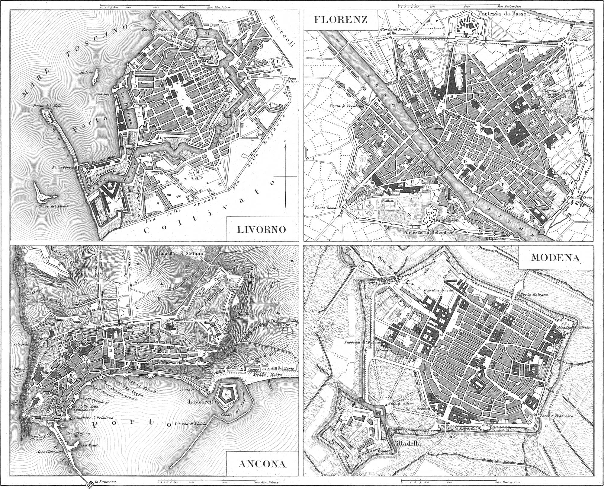
Leghorn Plate 44
Leghorn, or Livorno, in the Grand Duchy of Tuscany, is situated in a low country on the Mediterranean Sea, and a canal connecting the city with the Arno. With its excellent and double harbor (Darsena) and large Mole, it is one of the most important places in Italy for the pursuits of navigation and commerce. The population amounts to 80,000 souls, including 5000 Jews, who possess two thirds of the town; there are also Greeks, Armenians, and Turks. The north part of the city, termed New Venice, and intersected extensively by canals, is very regularly built. The finest street is the Strada Ferdinanda; the rest are straight and well paved, but rather narrow and obscure. Among the buildings of note are: the Grand Ducal Castle; the Synagogue; the Turkish Mosque; the colossal marble statue of Ferdinand I., in front of the harbor; the Arsenal; the Quarantine establishment, with three Lazarettoes, and especially the Magazine for goods coming from lands infested with the plague; the large hospitals; a lighthouse in the sea, with 214 steps; an aqueduct of nine miles; an enormous cistern. The Leopold Railroad connects Leghorn with Florence.
Explanation of the Plan.
- A. Piazza dei Grani.
- Piazzetta la Crocetta.
- Piazza S. Marco.
- Piazza de’ Grani.
- Piazza della Posta.
- Piazza dell’ Erba.
- Piazza Rangoni.
- Piazza dei Condotti.
- Piazza d’Armi.
- Piazza della Darsena
- Piazza S. Benedetto.
- Cimetero Vecchio.
- Cimetero Inglese.
- Cattedrale.
- Palazzo Reale.
- Cancelleria Communale.
- I Tre Palazzi.
- Real Dogana.
- Palazzo del Governo.
- Magazzino del Sale.
- Arsenale.
- Casone.
- Fortino.
- Parlatori.
- Teltoia del Fanale.
- Teltoia Nuova.
- Teltoia della Cuoia.
- Porta Murata.
- Porta Capuccini.
- Porta Colonetta.
- Porta Nuova.
- Porta San Marco.
- Porta a Pisa.
- Via dei Capuccini.
- Via del Lazzaretto S. Rocco
- Via del Ponte de’ Lami.
- Via dello Spalto S. Cosimo.
- I Condotti Nuovi.
- Via Disperata.
- Borgo Reale.
- Via delle quattro Cantonate.
- Via Reale.
- Via Serristori.
- Via S. Francesco.
- Via S. Giulia.
- Via del Monte.
- Via Grande.
- Via del Giardino.
- Via dell’ Annunziata.
- Via di S. Giovanni.
- Via del Porticciolo.
- Via Borra.
- Via S. Marco.
- Via del Corso.
Florence Plate 44
Florence (Firenze), surnamed “the beautiful,” the charming capital of Tuscany, with a population of 105,000, is situated in a fertile plain on the Arno, surrounded by mountains. It is protected by two citadels, and possesses streets which are mostly narrow, although clean (excellently paved in mosaic work, with plates of basalt), amongst which the finest are the Via Larga and the Corso. There are 160 public monuments, 10 fountains, 170 churches and chapels, 89 monasteries and nunneries, 8 theatres, and 17 large squares. The finest of the last are the Grand Duke’s Square, with the column of Cosmo I., and a marble group (Rape of the Sabine women), by John of Bologna; the square Santa Maria, with two obelisks, and the square dell’ Annunziata, with two fountains, and the statue of Ferdinand I. The finest churches and chapels are: the Cathedral, Santa Maria del Fiore, 500 feet long, covered externally with squares of black and white marble, chess-board fashion, and with an octagonal dome 380 feet high, and a separate tower of 280 feet; the church St. Maria Novella, with many painted windows, and other pictures; Santa Croce, with the tombs and monuments of Galileo, Macchiavelli, Alfieri, and Michael Angelo; the chapel of St. Lawrence Church, adorned with jasper, lapis lazuli, and other precious stones, and with monuments of the Grand Duke; the baptizing chapel, ii Battisterio, in which ah children born in Florence are baptized, with the metal folding doors by Ghiberti; the church and convent of the Holy Ghost; the Church del Carmine, with a finely painted dome, &c. The royal residence, called Palace Pitti, to which belongs the garden Boboli, is over 500 feet long, and contains the finest works of art, in eight saloons and several hundred rooms; the same may also be said of the contiguous Palazzo Vecchio, the former residence of the Grand Duke, with its fine Loggia or Hall. More celebrated and better worth seeing than either, is the gallery termed Palazzo degli Uffici, which is directly opposite, and whose third story contains, in twenty-three saloons and apartments, the rarest master-pieces of art, paintings, engravings, statuary, gems, mosaics, bronzes, and coins, all combined. Another large collection is that of the Academy of Arts; and the palaces of the old Florentine families, Riccardi, Strozzi, Gerini, and Corsini, and others, are likewise rich in gems of art. Among the scientific collections may be mentioned: the Medicean Library in the Convent of St. Lorenzo, with 120,000 volumes; the Grand Ducal and Magliabecchian Library; the Marucelli Library; the Museum of Natural Sciences, and the Botanic Garden. At the head of the scientific and literary institutions stands the University, founded in 1438, although for the Italian language the Accademia della Crusca is far more renowned; chief among the charitable institutions is the great St. Mary’s Hospital, capable of accommodating seven hundred sick persons.
Explanation of the Plan.
- Piazza S. Marco.
- Piazza Vecchia.
- Piazza S. Maria Novella.
- Piazza del Gran Duca.
- Piazza S. Croce.
- Piazza del Carmine.
- Piazza S. Spirito.
- Piazza dei Pitti.
- Chiesa S. Maria Novella.
- Chiesa S. S. Trinità.
- Chiesa S. Lorenzo.
- Teatro del Cocomero.
- Duomo S. Maria del fiore.
- Chiesa S. Marco.
- Accademia di Belle Arti.
- Chiesa S. Annunziata.
- Teatro degli Intrepidi o Torro Nuovo.
- Ospedale de S. Maria Nuovo.
- Teatro della Pergola.
- Chiesa S. Maria Maddalena de’ Pazzi.
- Chiesa S. Ambrogio.
- Teatro Alfieri.
- Chiesa S. Croce.
- Galleria Medici.
- Palazzo Vecchio.
- Palazzo Pitti.
- Museo di Storia Naturale.
- Teatro Goldoni.
- Chiesa S. Spirito.
- Chiesa il Carmine.
- Via Chiara Boffi.
- Via de’ Serragli.
- Via S. Agostino.
- Via Maggio.
- Via della Nunziatina.
- Via del Campuccio.
- Via dell’ Orto.
- Borgo S. Frediano.
- Borgo S. Jacopo.
- Lungo l’Arno.
- Via de’ Bardi.
- Palazzuolo.
- Borgo Ognissanti.
- Pantano di Ripoli.
- Via della Scala.
- Valfonda.
- Via Faenza.
- Via Vangelista.
- Via dei Ciliegio.
- Via degli Alfani.
- Via dei Pilastri.
- Via S. Zanobi.
- Via del Campo Accio.
- Via S. Gallo.
- Via Larga.
- ′ Via del Cocomero Maglio.
- ′ Via S. Bastiano.
- ′ Via Borgo di Pinti.
- ′ Via Pietrapiana.
- ′ Borgo la Croce.
- ′ Via dell’ Agnola.
- ′ Via delle Fornaci.
- ′ Via Ghibellina.
- ′ Via dei Malcontenti.
- ′ Corso.
- ′ Borgo degli Albizzi.
- ′ Via delle Torri.
- ′ P. S. Maria Mercato Calmara.
- ′ Via del Giglio.
- ′ Via de’ Ginori.
- ′ Ponte di ferro.
- ′ Ponte alia Caraja.
- ′ Ponte S. Trinitade.
- ′ Ponte Vecchio.
- ′ Ponte alle Grazie.
Ancona Plate 44
Ancona, the most important harbor and place of trade in the Papal States; and capital of the delegation of the same name, is situated on the Adriatic Sea, between two hills, one of which carries the citadel, and the other the cathedral. Its present population is 24,000 (or 32,000, according to other estimates), amongst which are 5000 Jews. The streets, with few exceptions, are narrow and crooked. The finest building is the Exchange: other objects of interest are the great Quarantine Building; the great Triumphal Arch, of white marble, erected in honor of the Emperor Trajan, and of Pope Benedict XIV., the one as builder, the other as restorer of the Mole; the remains of a Roman Amphitheatre, and the Mole on the harbor, 2000 feet long.
Explanation of the Plan.
- Piazza S. Bartolomeo.
- Piazza del Commune.
- Piazza S. Francesco.
- Piazza Grande.
- Piazza del Teatro.
- Piazza Nuova.
- Piazza Sotto Fortezza.
- Piazza S. Maria.
- Piazza S. Primiano.
- Duomo Cattedrale.
- S. Domenico Convento.
- SS. Annunziata.
- S. Francesco ad Alto Convento.
- La SS. Concezione.
- S. Agostino Convento.
- SS. Sacramento.
- Francesco del Ospedale.
- II Gesu Seminario.
- San Palazia.
- San Pellegrino.
- Palazzo Apostolico.
- Palazzo del Commune.
- Teatro nuovo Casino.
- Loggia de’ Mercanti.
- Arsenale.
- Porta Farina.
- Porta Calamo.
- Porta Capo di Monte.
- Strada nuova del Duomo.
- Via Grande.
- Strada Nembrini.
- Strada delle Scuole.
- Strada Calamo.
- Strada dell’ Annunziata.
- Strada S. Pietro.
- Strada della Loggia.
- Strada del Porto.
- Strada grand e di Capo di Monte.
Modena Plate 44
Modena, the capital of the Italian Duchy of Modena, with a population of 28,000, is situated on a canal connecting the Secchio with the Panaro. It is well built, and most of the streets have covered ways or arcades on the side. The beautiful castle is well arranged internally, and contains an excellent collection of paintings and antiques, although the former picture gallery was sold to Dresden in 1746. The town has thirty-four churches and three convents. Among the scientific institutions are: a University, a Library, an Academy for nobles, a Society of Sciences, &c. The former citadel now serves as a house of correction. The city itself is very ancient. In the time of the Romans it was called Mutina.
Explanation of the Plan.
- Palazzo Ducale.
- Ministerio di Buon Governo e Polizia, Accademia delle Belle Arti, &c.
- Ministerio delle Finanze.
- Scuderie Ducali, Uffizio Tipografico.
- Palazzo Communale.
- Duomo e Vescovado.
- Seminario Vescoville.
- Università.
- Convitto Medico.
- Convitto Legale.
- Convitto Matematico.
- Collegio dei Gesuiti.
- Dogana.
- Tribunali di Giustizia.
- Congregazione di S. Filippo Neri.
- Intendanza delle Opere pie.
- Educandato di S. Paolo.Teatro Communale.
- Tipografia Camerale.
- Chiesa del Voto.
- Madonna del Popolo.
- S. Giovanni decollate.
- P. Domenico.
- Terziarie di S. Domenico.
- Paradiso.
- Salesiane.
- S. Bartolomeo.
- San Salvatore.
- San Paolo.
- San Carlo.
- Santa Maria Pomposa.
- S. Sebastiano.
- Crocefisso.
- San Barnaba.
- San Pietro.
- Santa Trinità.
- Corpus Domini.
- San Vicenzo.
- San Francesco.
- Chiesa Tedesca.
- Terziare di S. Francesco.
Glossary to the Geographical Maps
Including a complete glossary of all those German geographical names and terms on the plates, which vary from the English, comprising also the modern names of ancient places, rivers, &c. The Longitude in the Maps is reckoned from the meridian of Ferro. To reduce it to the meridian of Greenwich (which is that used throughout the text) add 18° 10′ for W. long., and subtract the same for E. long.
View glossary
A
- Abasgia, Abkhas.
- Abassien, Abassi (tribe in North Africa).
- Abbitihes, Abbitibbe River.
- Abdera, Adra.
- Abrincate, Abrineafui.
- Abyssinien, Abyssinia.
- Acci, Guadix.
- Achalziche, Akalzike.
- Achen, Aix la Chapelle.
- Acincum, Buda Pest.
- Adagk, Island Adack.
- Admiralitäts Is., Admiralty Islands.
- Adrianopel, Adrianople.
- Adriatisches Meer, Adriatic Sea.
- Adulis, St. Gothard.
- Ægadische In., the islands of Levanso, Favignana, and Maritime (the ancient Ægades).
- Ægaisches Meer, Archipelago.
- Ægypten, Egypt.
- Ægyptische Schöne wovon 18\(\frac{4}{5}\) a. d. Gr., Egyptian miles 18\(\frac{4}{5}\) to a degree.
- Ælana, Akaba.
- Æmona, Laybach.
- Æquat. d. ewigen Schnees, Equator of perpetual snow.
- Æquatorgrenze d. Schneefalles, Equatorial boundary of snow.
- Æquatorialgrenze d. europ. tropn. Getreides, Equatorial boundary of European tropical grain.
- Æquaiorialgr. des ewigen Schnees, Equatorial boundary of perpetual snow.
- Æthiopien, Ethiopia.
- Æthiopisches Meer, Ethiopian Sea.
- Agrigentum, Girgenti
- Aguja Sp., Cape Aguya.
- Akjerman, Akerman.
- Alands In., Aland Islands.
- Alanen, Alani.
- Albanien, Albany.
- Albaracin, Albarracin.
- Albersche, Alberche River.
- Albis, Elbe River.
- Albufeira, Albufera.
- Albufera See, Lake Albufera.
- Alemannen, Alemanni.
- Aleschki, Aleshki.
- Aleuten Insein, Aleutian Islands.
- Alexandrien, Alexandria.
- Algesiras, Al Gezira.
- Algier, Algiers.
- Alpen 1200 t. mittlere Höhe, Alps 1200 toises mean height.
- Alpen Gebirge, the Alps.
- Alpes Basiarnicæ, Lower Alps.
- Alpes Rhætiæ, Rhætian Alps.
- Alsen, Isle of Als.
- Alt Californien, Upper California.
- Alter Molo, Old pier.
- Amassera, Amasserah.
- Amboser Hochland, Ambose Highlands.
- Amenis, Ameni Island.
- Amiranten I., Amir ante Islands.
- Atnisia, Ems River.
- Ammonia, Hargiah.
- Ancyra, Angora.
- Andalusien, Andalusia.
- Andamanen, Andaman Islands.
- Andes von Peru, the Andes of Peru.
- Andes von Quito, the Andes of Quito.
- Andöe, Island of Andoen.
- Andros mit Hafen, Andros with port.
- Anemurium, Cape Anamour.
- Angela, Angli.
- Anten, Antæ (Sarmatian tribe).
- Antinoe, Enseneh.
- Antwerpen, Antwerp.
- Anurigrammum, Anurajapoera.
- Aornus, Ohund.
- Aosta Thai, Aosta Valley.
- Apelioies (Ost), Southeast trade-wind.
- Apenninen Geb., the Apennines.
- Apulien, Apulia.
- Aquæ Sextiæ, Aix.
- Aquitanien, Aquitania.
- Arabien, Arabia.
- Arahische Wüste, Arabian Desert.
- Arab. Mb., Arabian Gulf.
- Arabisches od. Fersisches Meer, Arabian or Persian Sea.
- Arachosia, S. E. Cabul.
- Arachoius, Lora River.
- Aral See, Aral Sea.
- Aran, Karabagh.
- Araxes, Aras River.
- Arbela, Arbay.
- Archangelsk, Archangel.
- Archipel von Ncu Britannia, Archipelago of New Britain.
- Archipel der Niedrigen Inseln, Low Islands.
- Archipelagus, Archipelago.
- Ardennen, Ardennes.
- Arelaie, Aries.
- Argolische In., Archipelago of Nauplia.
- Argelis, Argellez.
- Argentoratum, Strasbourg.
- Argonnen Wald, the Argonne Forest.
- Aria, Khorasan.
- Aria See, Lake of Zarrah.
- Ariaspæ, Ariaspes (inhabitants of Aria, in ancient Drangiana, in Persia).
- Ariminum, Rimini.
- Armenier, Armenians.
- Armoricum, ancient Aquitania (S. W. France).
- Arnheim, Arnhem.
- Aroe, Patras.
- Arsanus, Murad River.
- Arsinoe, Suez.
- Art. Magazin, Artillery Arsenal.
- Aru In, Aroo Islands.
- Arvernum, Auvergne.
- Asiatisches Russland, Asiatic Russia.
- Asiatisckes Sarmatn., Asiatic Sarmatia.
- Asow, Azov.
- Asowsches Meer, Sea of Azov.
- Assomtion, Asuncion.
- Assyrn., Assyria.
- Asia, Asti.
- Asturica, Astorga.
- Asturien, Asturias.
- Athabasca S., Lake Athapescow.
- Athen, Athens.
- Athena, Athens.
- Athribis, Tel Atrib.
- Atlantischer Ocean, Atlantic Ocean.
- Atschin, Acheen.
- Attalia, Adalia.
- Aitici, Inhab. of Attica.
- Augila, Augela.
- Aug. Turinorum, Turin.
- Aug. Vindelicorum, Augsburg.
- Augustodunum, Autun.
- Aulona, Valona.
- Auster (Süd), South Wind.
- Australien, Australia.
- Austral. Busen, Gulf of Australia.
- Austrasien, Empire of Chlodwig.
- Avalites, Zeyla.
- Avalitischer G., Bay of Zeyla.
- Aventicum, Avenche.
- Avernum, Lake Avemo.
- Azania, Ajan.
- Azorische Inseln, Portugiesisch, the Azores, Portuguese.
- Azowsches Meer, Sea of Azov.
B
- B. von Athen od. v. Ægina, Bay of Athens or of Ægina.
- B. von Nauplia od. v. Argos, Bay of Nauplia or of Argos.
- Babadagh, Baba Dag.
- Bagistanus, Beesitoon.
- Bagous Geb., Bagous Mountains.
- Bahama Inseln, Bahama Islands.
- Bai u. Dorf Catalan, Bay and village of Catalan.
- Baiern, Bavaria.
- Baikal S. u. Geb., Baikal Lake and Mountains.
- Baireuth, Bayreuth.
- Bairischer Wd., Bavarian Forest.
- Baktrien, Bactriana.
- Balearen, Balearic Islands.
- Baleares, Balearic Islands.
- Balearischer Canal, Balearic Channel.
- Balkan Geb., Balkan Mountains.
- Balkasch S., Lake Balkash.
- Baltica, Sweden.
- Banasa, Meheduma.
- Banater Geb., Banat Mountains.
- Banater Milit. Grenge, Military frontier of the Banat.
- Banks Land, Banks’ Island.
- Barcelonnetti, Barceloneta.
- Barcino, Barcelona.
- Baschkiren, Bashkirs.
- Bass Strasse, Bass’s Strait.
- Bassislis, Bashnia.
- Baumwolle, Cotton.
- Baumwolle u. Reis, Cotton and Rice.
- Bayrische Alpen, Bavarian Alps.
- Bayrisches Hochland, Bavarian Highlands.
- Behrings Meer, Behring’s Strait.
- Behrings Meer od. Meer von Kamtschatka, Behring’s Strait or Kamtschatkian Sea.
- Belgien, Belgium.
- Belice, Belici River.
- Belochrobaten, Belochrobati (Slavonian tribe).
- Belzoi See, Lake Belzoi.
- Berenike, Bengazi.
- Berg Andros, Mount Andros.
- Berkley Sund, Berkeley Sound.
- Bermudas od. Sommer I., Bermudas or Somers Islands.
- Berner Alpen, Bernese Alps.
- Bernstein Küste, Amber Coast.
- Bessarahien, Bessarabia.
- Bieler S., Lake of Biel.
- Bjelos See, Lake Biellos.
- Biled-ul-gerid, od. Dattelland, Biled-ul-gerid, or Land of Dates.
- Biscayscher Meerbusen, Bay of Biscay.
- Bithynien, Bithynium.
- Blaue Bge., Blue Mountains.
- Bodensee, Lake of Constance.
- Böhmische Höhe, Bohemian Highlands.
- Böhmischer Kessel, Bohemian Basin.
- Bogen Indianer, Strongbow Indians (tribe of the Chippeways).
- Bolzoi, oder Grosser See, Bolzoi or Large Lake.
- Boreas (Nord), North Wind.
- Borysthenes, Pripet River.
- Borystheves (Danapris), Dniepr River.
- Bosnien, Bosna.
- Bostra, Boszra.
- Bothnischer Busen, Gulf of Botnia.
- Bracara, Braga.
- Brasilien, Brazil.
- Brasilische Gehirge, Brazil Mountains.
- Brasiliscke Stromung, Brazil Current.
- Brasilisches Guyana, Brazil Guyana.
- Braunschweig, Brunswick.
- Brede Bugt, Bay of Brede.
- Brienzer S., Lake of Brienz.
- Brigantium, Briançon.
- Britannien, Gr. Britain.
- Britisches Guyana, British Guyana.
- Brivates Haf, Bay of Brest.
- Brüssel, Brussels.
- Brundisium, Brindisi.
- Brundusium, Brindisi.
- Bucephala, Ibylum.
- Bucharest, Bukarest.
- Bucharien, Bokhara.
- Buchweitzen, Buckwheat.
- Bucinarische In., Buccinarian Islands.
- Bulgaren, Bulgari (tribe on the lower Danube).
- Burdigala, Bordeaux.
- Burgunder, Burgimdians.
- Busen von Bengalien, Bay of Bengal.
- Busen von Cadix, Bay of Cadiz.
- Busen Carpentaria, Bay of Carpentaria.
- Busen v. Danzig, Bay of Dantzig.
- Busen von Lepanto oder von Korinth, Gulf of Lepanto or of Corinth.
- Busen v. Lion, Gulf of Lyons.
- Busen v. Lubeck, Bay of Lubeck.
- Busen von Panama, Bay of Panama.
- Busen von Taranto, Gulf of Taranto.
- Busen von Tehuantepec, Gulf of Tehuantepec.
- Busen von Triest, Gulf of Trieste.
- Busen von Venedig, Bay of Venice.
- Byblos, Djebail.
- Byzacium, Tunis.
- Byzant., Constantinople.
C
- C. d. guten Hoffnung, Cape of Good Hope.
- C. Horner Stromung, Cape Horn Current.
- Cabillonus, Chalons.
- Cæsar Augusta, Saragossa.
- Cætobriga, Setobal.
- Cajeta, Gaeta.
- Caledonien, Caledonia.
- Caledonischer Canal, Caledonian Canal.
- Calvadosfelsen, Calvados Rocks.
- Canal oder La Blanche, the British Channel.
- Canal u. Strömung v. Mozambique, Channel and current of Mozambique.
- Canal von Yucatan, Channel of Yucatan.
- Canarische Inseln, Canary Islands.
- Candriaces, Nugor River.
- Canopus, Aboukir.
- Cantabrisches Geb. 600 t., Santillanos Mountains 600 toises.
- Cantal G., Cantal Mountains.
- Cap Strom, Cape current.
- Cap u. Ins. Breton, Cape and Island of Breton.
- Cappadocien, Cappadocia.
- Capsa, Wataras.
- Capstadt, Cape Town.
- Capverdische Inseln, Cape Verde Islands.
- Caraibisches Meer, Caribbean Sea.
- Caralis, Cagliari.
- Carenisches Gebirg, Sutherland Highlands.
- Carmania, Kerman.
- Carpathus, Scarpanto.
- Carteja, Ocana.
- Carthaginiensis Sinus, Gulf of Tunis.
- Carthago, Carthage.
- Carthago nova, Cartagena.
- Casp. Engpasse, Caspian or Caucasian passes.
- Caspisches Meer, Caspian Sea.
- Caspisch. See liegt 33 t. unter d. Niveau d. Oceans, Caspian Sea, lies 33 toises lower than the level of the ocean.
- Caspische See, Caspian Sea.
- Cassiterides Ins., Scilly Islands.
- Catalonien, Catalonia.
- Celænæ, Dingla.
- Cerasus, Keresoun.
- Cevennen, Cevennes Mountains.
- Chalifat der Abassiden, Caliphate of the Abassides.
- Charolais Geb., Charolles Mountains.
- Chemnis, Ekhmin.
- Cherson, Kherson.
- Chersonesus, Cape Razatin.
- Cheviot Gehirge, Cheviot Hills.
- Chile, Chili.
- China Wälder, Bathbark Forests.
- Chinesisches Meer, Chinese Sea.
- Chios, Scio.
- Choco Kette, Choco Mountain Chain.
- Chorasmia See, Lake Kharasm.
- Chorasmii, Kharasm.
- Churhessen, Electoral Hesse.
- Cihalis, Palanha.
- Cilicia, Itshih; Die Cilicischen Thore, the Passes of Itshili.
- Cimbrische Halh I., Cimbrian Peninsula (Jutland).
- Clearwater See, Clearwater Lake.
- Cnossus, Maeritichos.
- Colchis, Mingrelia.
- Colchischer G., Gulf of Mingrelia.
- Colonia, Cologne.
- Comana, Bostan.
- Comer S., Lake of Como.
- Comum, Como.
- Conimhriga, Coimbra.
- Constantinopel, Constantinople.
- Constantinopolis, Constantinople.
- Constanz, Constance.
- Cooks Strasse, Cook’s Strait.
- Cophas, Guadel.
- Cophes, Ghizni River.
- Coptos, Ghouft.
- Corcyra, Corfu.
- Cordofan, Kordofan.
- Corduba, Cordova.
- Corps unter Hephæstion, Corps under Hephæstion.
- Croatien, Croatia.
- Croatische Militair Grenze, Croatian military frontier.
- Curene, Kuren.
- Curland, Courland.
- Cydonia, Canea.
- Cynopolis, Nesle Sheik Hassan.
- Cypern, Cyprus.
- Cyrene, West Barca.
- Cyropolis, Enzellee.
- Cyrus, Politica.
- Cythere, Citria.
- Cyzicus, Kyzik.
D
- Dacia, Hungary and Transylvania.
- Daenemark, Denmark.
- Dakien, Dacia (Hungary).
- Dalmatien, Dalmatia.
- Dampfschiffe von Triest der Œstn. Lloyd Ges., Steamers of the Austrian Lloyd Company from Trieste.
- Dänen, Danes.
- Danubius, Danube River.
- Danzig, Dantzig
- Daphne, Daia.
- Dardanellen Schlösser, Palaces at the Dardanelles.
- Dardanellen Str., Dardanelles.
- Darnis, Dema.
- Das Alpen Gebirgc, the Alps.
- Das Po Thai, the Po Valley.
- Daurisches Alpenland, the Da Oural Alps (branch of the Oural Mountains).
- Bavia Strasse, Davis’s Strait.
- Delphi, Castri.
- Dembo Hochland, Dembo Highlands.
- D’Entrecasieanx Spitze, Point d’Entreeasteaux.
- Der Normannen Reiche, the Norman Empires.
- Der Spiegel des todten Bleeres liegt 220 t. tiefer als der Ocean, the surface of the Dead Sea lies 220 toises below the level of the ocean.
- Der Wash, the Wash.
- Dergh See, Lake Derg.
- Dertosa, Tortosa.
- Deutsche Meilen 15 auf den Grad, German miles 15 to the degree.
- Deutsche unter Kaiser Friedrich II., Germans under Emperor Frederick II.
- Deutsches Kaiserreich, German Empire.
- Deva, Ayas.
- Die Aleuten od. Catharinas Archipel, the Aleutian Islands or Catharine’s Archipelago.
- Die Aleutischen Inseln, the Aleutian Islands.
- Die Azoren, the Azores.
- Die bekannte Welt des Alterthums, the world known to the Ancients.
- Die Carolinen, the Caroline Islands.
- Die 3 Oder Mundn., the three mouths of the Oder.
- Die Eols Grotten, the Grottoes of Æolus.
- Die grosse osteuropdische Ebene in welcher kein Punkt die Höhe von 180 t. erreicht, the large East-European plain, in which no point reaches the height of 180 toises.
- Die Nord See oder das deutsche Meer, the North Sea or the German Sea.
- Die Ostsee, oder das Baltische Meer, the Baltic.
- Die Philippinen, the Philippine Islands.
- Die Schweiz, Switzerland.
- Die sieben Kuhfirsten, the Seven Cowridges.
- Diemtiger Th., Diemtig Valley.
- Dinarisches Alpen Gebirg, Dinarian Alps (on the lower Danube).
- Dio Adelphi (Die 2 Brüder), Die Adelphi (The Two Brothers).
- Dioscorides I., Island of Socotra.
- Dioscurias, Iskuria.
- District diesseits der Donau, District north of the Danube.
- District diesseits der Theiss, District west of the Theiss.
- District jenseits der Donau, District beyond the Danube.
- District jenseits der Theiss, District beyond (east of) the Theiss.
- Dobrudscher, Dobrodje.
- Donau, Danube.
- Donaumündungen, Mouths of the Danube.
- Donauwörth, Donauwerth.
- Donische Kosaken, Cossacks of the Don.
- Dora Baltea, Doria Baltea River.
- Drapsaea, Bamia,n.
- Drontheim, Trondheim.
- Dschebil el Kamar od. Mond Geb., Gebel Komri, or Mountains of the Moon.
- Duna, Dvina River.
- Dunkirchen, Dunkirk.
- Durius, Douro River.
- Durovernum, Canterbury.
E
- Eblana, Dublin.
- Eboracum, York.
- Ebro Mündung, Mouth of the Ebro.
- Ebusus, Iviza.
- Eisenbahnen, Railroads.
- Eisenbahnkarte von Mitteleuropa, Railroad chart of Central Europe.
- Eismeer, Arctic Ocean,
- Eisstarre Sand u. Morast Fldche, Frozen Sand and Swamp Plain.
- Elusa, Eauze.
- Emerita Aug., Merida.
- Emir at v. Cordova, Emirate of Cordova.
- Enara See, Lake Enara.
- Engländer unter Richard Lowenherz, the English under Richard Cœur de Lion.
- Engl. Colonien am Schwanftusse, K. Georg’s Sund und N. S. Wales, English Colonies on Swan River, King George’s Sound, and New South Wales.
- Englische Meilen 69\(\frac{22}{100}\) uf den Grad, English miles, 69\(\frac{22}{100}\) to the degree.
- Engpass v. Kaipha, Pass of Kaipha.
- Ephesus, Ayasaluk.
- Epidaurus, Ragusa Vecchia.
- Epirus, Albania.
- Eregli, Erekli.
- Erkldrung der Zahlen, Explanation of the figures.
- Erne See, Erne Loch.
- Erymanthus, Mount Olonos.
- Eskimos, Esquimaux.
- Esthland, Esthonia.
- Euboa, Negropont.
- Euphrai, Euphrates.
- Europa vor der Französischen Revolution, Europe before the French Revolution.
- Europa zur Zeit der Kreuzzüge, Europe during the Crusades.
- Europa zur Zeil Karls des Grossen, Europe at the time of Charlemagne.
- Europäisch Sarmatien, European Sarmatia.
- Europäische Besitzungen in Nord Guinea, European possessions in North Guinea.
- Europäisches Russland, European Russia.
- Europäisches Scythien, European Scythia.
F
- Fadejewski, Fadevskoi.
- Fær Œer, Faro Islands.
- Falklands Ins., Falkland Manas.
- Falsche Bai, Bay of Falso.
- Faltschi, Faltsi.
- Fan Œ., Fano I.
- Favonius (West), West Wind (Zephyr).
- Feuerland, Terra del Fuego.
- Finnischer Busen, Gulf of Finland.
- Fischereien von Agoutinitza, Fisheries of Agoutinitza.
- Fittre See, Bahr Fittre.
- Flachs u. Hanf, Flax and Hemp.
- Flandern, Flanders.
- Flavia Cäsariensis, Central England.
- Flaviobriga, Bilbao.
- Flavionavia, Laviana.
- Flevus, Flevo, Zuyder Zee.
- Florentia, Florence.
- Florenz, Florence.
- Franken, Franconia.
- Frankfurt, Frankfort.
- Fränkisches Italien, Frankish Italy.
- Fränkisches Plateau, Franconian plateau.
- Frankreich, France.
- Franzos. Guyana, French Guyana.
- Franzosische Lieues 25 auf den Grad, French leagues 25 to the degree.
- Franzosen unter Philipp August, The French under Philip Augustus.
- Franzosen unter Ludwig IX., The French under Louis IX.
- Freiburg, Freeburg.
- Freie Indianer, Free Indians.
- Freundschafts oder Tonga In., Friendly or Tonga Islands.
- Friedens Fl., Peace River.
- Frobischer Str., Frobisher’s Strait.
- Fuchs Ins., Fox Islands.
- Fünen, Fyen.
- Fuglœ, Bird Island.
- Fürstm. Benevent, Principality of Benevento.
- Fürstenthum Neuenburg, Principality of Neuenburg.
G
- Gabæ, Chavos.
- Gades, Cadiz.
- Gaditanum, Gibraltar.
- Galætia, Anadolia.
- Galicien, Galicia.
- Galizien, Galicia.
- Gallien, Gallia (France).
- Gallische Wegestunden wovon 50 auf den Grad, Gallic miles 50 to the degree.
- Gangischer oder Indischer Golf, Bay of Bengal.
- Garamantes, Fezzaneers and Tibboo (tribe).
- Garda See, Lake of Garda.
- Gaugamela, Kamalis.
- Gaulos, Island of Goza.
- Geb. v. Granada, Granada Mountains.
- Gebirge von Auvergne, Mountains of Auvergne.
- Gedros, Mekran.
- Gelbes Meer, Yellow Sea.
- Genf, Geneva.
- Genfer See, Lake of Geneva.
- Gent, Ghent.
- Genua, Genoa.
- Geographen B., Geographer’s Bay.
- Geogr. Meilen 15 auf den Grad, Geographical miles 15 to the degree.
- Gepiden, Gepidæ (tribe).
- Germanen, Germans.
- Germanien, Germany.
- Germanische Meer, North Sea.
- Germanische Tiefebene, German Low Plain.
- Gerste, Barley.
- Gerste, Hafer, Roggen, Barley, Oats, Rye.
- Gerste, Roggen, Kartoffeln und Buchweitzen, Barley, Rye, Potatoes, and Buckwheat.
- Gesellschafts In., Society Islands.
- Gesoriacum, Boulogne.
- Geten, Getæ (tribe).
- Gletscher, Glacier.
- Glilckliches Arabien, Arabia Felix.
- Gogana, Congoon.
- Gökssckai See, Lake Gokshai.
- Goldener Chersonesus, Golden Khersonesus (Malaya).
- Gordium, Sarilar.
- Gorsynia, Atchicola.
- Gothen, Goths.
- Gr. Bären See, Great Bear Lake.
- Gr. Minsk oder Caledonisches Meer, Great Minsh or Caledonian Sea.
- Gr. Sclaven S., Great Slave Lake.
- Grampian Gebirge, Grampian Mountains.
- Graubündner Alpen, Grison Alps.
- Griechenland, Greece.
- Griechisches Italien, Greek Italy.
- Grönland, Greenland.
- Gross Britannien und Ireland, Great Britain and Ireland.
- Gross Phrygia, Phrygia Major.
- Gross Russland, Great Russia.
- Grosse Antillen, the larger Antilles (West India Islands).
- Grosse Eskimos, Great Esquimaux.
- Grosser Atlas, Mount Atlas.
- Grosser oder Stiller Ocean, Pacific Ocean.
- Grossherz. Hessen, Grand Duchy of Hesse.
- Grune Berge, Green Mountains.
- Grimes Vorgebirge, Cape Verde.
- Gurtel des Getreides, Zone of the grains.
- Gurtel ohne Cultur, Zone without cultivation.
- Gurdus, Kamah River.
H
- H. l. or Halbinsel stands for “Peninsula” before the respective names.
- Haag, the Hague.
- Habesch, Habesh.
- Hadrianopolis, Adrianople.
- Hæmus, Balkan Mountains.
- Haf. V. or Hafen von stands for “Port of” before the respective names.
- Hafer, Oats.
- Hafer u. Gerste, Oats and Barley.
- Hafer u. Weitzen, Oats and Wheat.
- Halbinsel Methana, Peninsula of Dara (Methana).
- Halicarnassus, Boodroom.
- Haliez oder Galizien, Galicia.
- Han Hai (Südl. Meer), South Sea.
- Harz Gb., Harz Mountains.
- Hasen Ind., Hare Indians.
- Haupt Æquatorial Stromung, Principal equatorial current.
- Haupstadt, Capital.
- Hebräische Stadien woven 750 a. d. Gr., Hebrew stadia 750 to the degree.
- Hebriden oder Western Inseln, Hebrides or Western Islands.
- Hecatompylos, Danghan.
- Hedschas, Hedjas.
- Heiliges Vgb., Promontorium Sacrum.
- Heliopolis, Baalbec.
- Hellas, Greece.
- Hellespontus, Dardanelles.
- Helsingör, Elsinore.
- Heniochi, Tribe in Armenia.
- Hermopolis, Eshmounein.
- Hermunduren, Hermunduri (tribe in central Germany).
- Herodots Erdtafel, Herodotus’s Map of the World.
- Heruler, Heruli (tribe in North Germany).
- Herzogl. Sächsische Länder, Saxon Duchies.
- Herzogthum, Duchy.
- Hibernien, Hibemia.
- Hinter Rhein, Hind Rhine (one of the rivulets tributary to the Rhine).
- Hippo Regius, Bona.
- Hispalis, Seville.
- Hispanien, Spain.
- Hoch Alp, High Alp.
- Hoch Sudan, Soudah Mountains.
- Hochland von Africa, Higjilands of Africa.
- Hohe Taiarei, Tartar Highlands.
- Höher Atlas, Mount Atlas.
- Hügelgruppe v. Sandomir, Group of Hills of Sandomir.
- Hunds Ribben Ind, Dogrib Indians.
- Hunigaren oder Ungrier, Hungarians.
- Hydraotes, Ravee River.
- Hypanis, Kuban River.
- Hyphasis, Beyah River.
- Hyrcania, Gyrgaun.
- Hyrkanisch. Meer, Caspian Sea.
I/J
- I., Ia., Ins., or Insel stands for “Island” before the respective names.
- I. Helgoland, Island of Heligoland.
- I. Kängurah, Kangaroo Island.
- I. u. Stadt Cayenne, Island and Town of Cayenne.
- Jacobs Thai, Jacob’s Valley.
- Jadera, Zarah.
- Japanisches Meer, Sea of Japan.
- Jasygien, Jassygia.
- Jaxartes, Sihon River.
- Jazygen (Sarmafen), Sarmatians.
- Ibenes, Ebro River.
- Iberia, Georgia.
- Ickthyophagen, Fish-eaters.
- Iconium, Konia.
- Jenseits d. Ganges, Beyond the Ganges.
- Jenseits d. Imaus, Beyond the Altai.
- Jernis, Dunkerrin.
- lllyricum, Illyria.
- Illyrien, Illyria.
- Im Sommer 15°, In the summer 66 degrees F.
- Im Winter 5°, In the winter 43 degrees F.
- Imandra See, Lake Imandra.
- Imaus Geb., Altai Mountains.
- Indischer Ocean, Indian Ocean.
- Indsche Burun, Cape Indjeh.
- Indus Mundn., Mouths of the Indus.
- Ins. unter d. Winde, Caribbean Islands.
- Ins. d. gunen Vorgebirges, Cape Verde Islands.
- Jomanes, Jumna River.
- Jonische Inseln, Ionian Islands.
- Joppe, Yaffa.
- Joux See, Lake Joux.
- Ipsus, Ipsilihissar.
- Irgis, Irghiz River.
- Irische See, Irish Sea.
- Irland, Ireland.
- Irtisch, Irtish River.
- Is, Hit.
- Isca, Exe River.
- Island, Iceland.
- Issedones, Mongolian tribe.
- Ister (Donau), Danube.
- Ister Mündn., Mouths of the Danube.
- Italien, Italy.
- Jitlich, Juliers.
- Jüten, Jutlanders.
- Juliobriga, Reynosa.
- Julische Alpen, Carnic or Julian Alps.
- Jura Geb., Jura Mountains.
- Jura Sund, Jura Sound.
- Juvavia, Saltzburg.
K
- K. Charlotte S., Queen Charlotte’s Sound.
- Kärnthen, Carinthia.
- Kaiser Canal, Emperor’s Canal.
- Kaiserthum Œsterreich, Empire of Austria.
- Kalmühen, Calmucks.
- Kamische Bulgaren, Kama Bulgarians.
- Kandle, Canals.
- Kanal von Bristol, Bristol Channel.
- Kaptschak, Cabjak (tribe in Bokhara).
- Karafta oder Sachalin, Caraphta or Sachalin.
- Karazubazar, Kara Soo.
- Karchedon, Carthage.
- Karischer B., Bay of Caria.
- Karmanien, Kerraan.
- Karolinen, Caroline Islands.
- Karpathen 2000 t. mittl. Höhe, Carpathian Mountains 2000 toises mean height.
- Karpathen Geb., Carpathian Mountains.
- Karpathisches Waldgehirge, Carpathian Forest.
- Kartagena, Cartagena.
- Karthago, Carthage.
- Kartoffeln u. Hafer, Potatoes and Oats.
- Kartoffeln u. Buchweitzen, Potatoes and Buckwheat.
- Kaspisches Meer, Caspian Sea.
- Kattegat, Cattegat.
- Kaukasien, Caucasia.
- Kaukasus Gebirge, Caucasian Mountains.
- Kaukasische Steppe, Caucasian Steppes.
- Keine Bäume ab. Graswuchs, No trees but grass.
- Kelten, Celts.
- Kemi See, Lake Kemin.
- Kgn. Charlotte I., Queen Charlotte’s Island.
- Kimbrischer Cherson, Cimbrian Chersonesus (Jutland).
- Kjölen Gebirge, Koelen Mountains.
- Kirchenstaat, Papal States.
- Kirgisen Horde, Kirghis Horde.
- Kirghisen Steppe, Earghis Steppes.
- Kizil Ermak, Kizil Irmak River.
- Kl. Antillen, Little Antilles (Caribbean Islands).
- Kl. Karpathen, Little Carpathians.
- Kl. Kumanien, Kis Kunsag.
- Klein Phrygia, Phrygia Minor.
- Klein Russland, Little Russia (Russian Province).
- Kleinasien, Asia Minor.
- Kleine Kirgisen Horde, Little Kirghis Horde.
- Koblenz, Coblentz.
- Köln, Cologne.
- Kön. Georg Sund, King George’s Sound.
- König. Georg’s I., King George’s Islands.
- Königin Charlotte Sund, Queen Charlotte’sSound.
- Königreich stands for “kingdom” before the respective names.
- Konäguen, Tribe of Esquimaux.
- Kong Gebirge, Mountains of Kong
- Kopenhagen, Copenhagen.
- Kosaken, Cossacks.
- Krakau, Cracow.
- Krym, Crimea.
- Kuba, Cuba.
- Kupfer Ind., Copper Indians.
L
- L. I. Sund, Long Island Sound.
- Ladoga See, Lake Ladoga.
- Lakeneig, Lakeneigh.
- Laminium, Alambra.
- Lamose, Lamusa River.
- Lampsacus, Lamsaki.
- Lanai, Tribe in North Germany.
- Lancerote, Lancerota Island.
- Land der Finnen, Land of the Finns.
- Land der kleinen Eskimos, Land of the dwarf Esquimaux.
- Larice, Lack.
- Lauriacum, Lorch.
- Lausitzer Gebirg, Lusatian Mountains.
- Leba See, Lake Leba.
- Leman S., Lake Leman.
- Leptis, Lebida.
- Lerdalsoer, Lerdals Islands.
- Lesbos, Mytilene.
- Lessöewerk, Lessoe forge.
- Leucas, Amaxiki.
- Leuce, Island of Adasi.
- Ljæchen, Bohemians.
- Libyen, Africa.
- Libysche Wuste, Libyan Desert.
- Lieukieu In., Loo Choo Islands.
- Ligeris, Loire River.
- Liguria, Genoa.
- Ligurisches Meer, Gulf of Genoa.
- Likeio In., Loo Choo Islands.
- Lilybæum, Boe.
- Lindum, Lincoln.
- Liptauer Alp, Liptau Alps.
- Lissus, Allessio.
- Lithauer, Lithuania.
- Litus Saxonum, Coast of Sussex.
- Litwanen, Lithuania.
- Livadien, Livadia.
- Liviner Thai, Livin Valley.
- Livland, Livonia.
- Livorno, Leghorn.
- Lixus, Luccos River.
- Loja, Loxa.
- Lombardei, Lombardy.
- Lomond S., Lake Lomond.
- Londinum, London.
- Longobarden, Longobardi (Lombards).
- Lucentum, Alicante.
- Luceria, Lucera.
- Lüneburger Heide, Luneburg Heath.
- Lüttich, Liège.
- Lugdunensis, North West France.
- Lugdunum, Leyden.
- Lugovallum, Carlisle.
- Lugumkloster, Lugum Convent.
- Lulea See, Lake Lulea.
- Lumnitz B., Mount Lomnitz.
- Lusitania, Portugal.
- Lutitschen, Luititsi or Wilzi (Tribe in North Germany).
- Luzern, Lucerne.
- Lycaonia, N. W. Karamania.
- Lyon, Lyons.
- Lystra, Illisera.
M
- Maas, Meuse River.
- Maasstäbe, Scales.
- Macedonien, Macedonia.
- Mackenzie In., Mackenzie’s Islands.
- Macquarie In., Macquarie’s Island.
- Madgyaren, Magyars.
- Mähren, Moravia.
- Mährische Höhe, Moravian Highlands.
- Mælar See, Lake Maelar.
- Maeotis See, Sea of Azov.
- Magelhaens Strasse, Straits of Magallan.
- Mahadia, Mahedia.
- Mahrah, Mahran.
- Mailand, Milan.
- Mainz, Mayence, Maynz.
- Mais und Weitzen, Indian Com and Wheat.
- Makarjew, Makariv.
- Mai Ström, Malstrom.
- Malaca, Malacca.
- Malmö, Malmo.
- Malmysch, Malmish.
- Malouinen, Falkland Islands.
- Mandeln, Almonds.
- Mandschurei, Manchooria.
- Manytsch, Manich River.
- Maraniten, Maranites, tribe in Arabia Felix.
- Marcomannen, Marcomanni, tribe in S. E. Germany.
- Mare Adriaticum, Adriatic Sea.
- Mare Caspium, Caspian Sea.
- Mare Erythrcsum (Indisches Meer), Indian Ocean.
- Mare Hyrcanum oder Caspium, Caspian Sea.
- Mare Internum (Mittelländisches Meer), Mediterranean Sea.
- Marea, El Khreit.
- Margaret In., Margaret’s Island.
- Margus, Murghab River.
- Marianen od. Ladronen, Marian Islands.
- Marinestunden 25 auf den Grad, Marine leagues 25 to the degree.
- Marisus, Maros River.
- Marmara Meer, Sea of Marmora.
- Marschall Inseln, Mulgrave Islands.
- Marseille, Marseilles.
- Martyropolis, Meia Farekin.
- Mascarenen Inseln, Mascarenhas Islands (Mauritius, Bourbon, &c.).
- Massaga, Massa.
- Massilia, Marseilles.
- Mater, Matter.
- Mauritania, Algiers.
- Mauritanien, Algiers.
- Maxima Cæsariensis, Northern England.
- Mb. V. Issus (Sinus Issilicus), Bay of Iskenderoon.
- Meder, Medes (nation).
- Mediolanum, Milan.
- Medus, Abkuren River.
- Meer Alpen, Maritime Alps.
- Meer von Ochotsh, Sea of Okotsk.
- Meer von Tarrakai, Gulf of Tartary.
- Meerb. v. Californien, Gulf of California.
- Meerb. v. Sues, Gulf of Suez.
- Meerbusen von Mexico, Gulf of Mexico.
- Meiningen, Meinungen.
- Melgig Sumpf, Melgig Swamp.
- Melitene, Malatia.
- Memel od. Nienien, Meman River.
- Memel Niederung, Tilsit Lowlands.
- Memnis, Korkor Baba.
- Memphis, Mangel Mousa, or Mit Raheni.
- Meninx, Jerba Island.
- Mergui In., Mergue Archipelago.
- Meroe, Gibbainy.
- Mesagna, Mesagne.
- Mesembria, Missivri.
- Mesopotamia, Al Gezira.
- Messana, Messina.
- Mettis, Metz.
- Mexicanische Küstenströmung, Mexican Coast Current.
- Miletus, Palatia.
- Militär Colonien, Military Colonies.
- Militair Grenze, Military Boundary.
- Minius, Minho River.
- Miö See, Lake Miœ.
- Mioritz See, Lake Mioritz.
- Mississippi Mündungen, Mouths of the Mississippi.
- Mittelländisches Meer, Mediterranean Sea.
- Mittlere Kirgisen Horde, Middle Kirghis Horde.
- Mittlere Temperatur nach Celsius, Mean temperature according to Celsius.
- Mittlere Temperatur nach Reaumur, Mean temperature according to Reaumur.
- Mogontiacum, Mayntz.
- Molukken, Molucca Islands.
- Molukken Str., Molucca Passage.
- Mond Gebirg, Mountains of the Moon.
- Mongolei, Mongolia.
- Monreale, Monreal.
- Montagues Noires, Black Mountains (Black Forest).
- Mordwinen, Mordwines (tribe in Asiatic Russia).
- Moreton C. u. B., Moreton Cape and Bay.
- Moscha, Morebat.
- Mosel, Moselle River.
- Moskenaso, Mosken Island.
- Moskau, Moscow.
- Moskwa, Moskow.
- Mosyneoci (tribe on the Black Sea).
- Mozyr, Mozir.
- Mühlhausen, Mulhouse.
- München, Munich.
- Mündung des Amazonen Stroms, Mouth of the Amazon River.
- Mündung der Elbe, Mouth of the Elbe.
- Mündung des Tajo, Mouth of the Tagus.
- Murray Busen, Murray Firth.
- Muthmassliche Grenze der den Alien bekannten Binnenländer von Afrika nach den Geographen Walkenaer und Gosselin, Probable boundary of the African inland known to the Ancients according to the geographers Walkenaer and Gosselin.
- Mutina, Modena.
N
- N. Schottl., North Scotland.
- N. W. Ausflusse des Æquatorial Stroms, Northwest termination of the Equatorial Current.
- Nabathæer, Nabathæi (nation in Arabia).
- Nadel Banck, Cape Agulhas.
- Naissus, Nissa.
- Namadus, Nerbuddah River.
- Napeta, Mograt.
- Narbona, Narbonne.
- Narbonensis, Narbonne.
- Nasamonen, Nasamones (tribe in West Barca).
- Natal Kusie, Natal Coast.
- Navusa mit Hafer, Nausa, with port.
- Nazareth Bank und Ins., Nazaret Bank and Island.
- Neagh S., Lake Neagh.
- Neapel (Neapolis), Naples.
- Nelson Canal, Nelson Channel.
- Nemausus, Nismes.
- Nerbudda, Nerbuddah River.
- Neu stands for “New” before the respective names.
- Neu Californien, New California.
- Neu Georgien, New Georgia.
- Neu Helvetien, New Helvetia.
- Neu Karthago, New Carthage.
- Neu Scotia, Nova Scotia.
- Neu Sibirien, New Siberia.
- Neue Hebriden, New Hebrides.
- Neue Saline, New Saltwork.
- Neuenburg, Neufchatel.
- Neuenburger S., Lake of Neufchatel.
- Neustrien, Neustria (the part of France lying between the Meuse, Loire, and the Atlantic Ocean).
- Nicosia, Island of Karos.
- Nicobaren, Nicobar Islands.
- Nicomedia, Izmid.
- Nieder Canada, Lower Canada.
- Nieder Ungarische Ebene, Lower Hungarian Plain.
- Niederl. Guyana, Dutch Guyana.
- Niederlande, Netherlands.
- Niger, Niger River.
- Nil, Nile River.
- Nil Mündungen, Mouths of the Nile.
- Nilus, Nile River.
- Nînes, Nismes.
- Niphates Geb., Sepan Mountains.
- Nizza, Nice.
- Norba Cæsaria, Alcantara.
- Nördlicher Oceanus, Arctic Ocean.
- Nördlicher Polarkreis, Arctic Circle.
- Nördlicher Wolga Rücken, Northern Volga Ridge.
- Nördliches Eismeer, Arctic Ocean.
- Nord stands for “North” before the respective names.
- Nord Afrikanische Stromung, North African Current.
- Nord Albinger, North Albingians (tribe in Holstein).
- Nord Georgien, North Georgia.
- Nord Georgien I., North Georgia Island.
- Nord See, North Sea.
- Noricum, Styria, Salzburg, &c.
- Norische Alpen, Noric Alps.
- Normanische Inseln, Normandy Islands (Guernsey, Jersey, Alderney, Sark).
- Northlined S., Northlined Lake.
- Norwegen, Norway.
- Notium Vgb., Mizen Head.
- Nuba See, Nuba Lake.
- Nuba Sumpf, Nuba Swamp.
- Nubier, Nubians (tribe).
- Nubische Wuste, Nubian Desert.
- Numidien, Numidia (East Algiers).
- Nursa, Norcia.
- Nymegen, Nimegue.
O
- Obdorisches Gebirge, Obdorsk Mountains (Northern extremity of the Oural Ms).
- Ober See, Lake Superior.
- Obi, Oby Island.
- Obotriten, Obotrites (Vandal tribe in North Germany).
- Oceanus Atlanticus, Atlantic Ocean.
- Oceanus Germanicus, North Sea.
- Ochus See, mit dem Kaspisches Meere fruher wahrscheinlich zusammenhängend, Ochus Sea
(Aral Sea), probably formerly connected with the Caspian Sea. - Odessus, Odessa.
- Odyssus, Odessa.
- Œ. L. V. Ferro, East longitude from the Island of Ferro.
- Œ. L. V. Paris, East longitude from Paris.
- Œca, Tripoli.
- Œlbäume, Olive trees.
- Œsterreich, Austria.
- Œsterreichische Alpen, Austrian Alps.
- Œsterreichische Landestheile, Austrian dependencies.
- Œsil. Gats, Eastern Ghauts.
- Œstliche Länge von Ferro, East longitude from the Island of Ferro.
- Œstliche Länge von Paris, East longitude from Paris.
- Offene B., Open Bay.
- Olisibon (Olisipo), Lisbon.
- Olite, Olitte.
- Olivenza, Olivenca.
- Olympia, Miracca.
- Olympische Stadien wovon 600 a. d. Grad, Olympic stadia, 600 to the degree.
- Onega See, Onega Lake.
- Ophiusa, Island of Formentera.
- Orange od. Gariep, Orange or Gariep River.
- Orangen, Oranges.
- Orbelus, Mt. Gliubotin.
- Orchoe, Bassora.
- Oregon oder Felsen Gebirge, Rocky Mountains.
- Oregon od. Columbia, Columbia River.
- Orinoco Mund., Mouth of the Orinoco.
- Orkaden, Orkney Islands.
- Orscha, Orsha.
- Orsowa, Orsova.
- Ortles Sp., Ortler Spitz.
- Ortospanum, Kandahar.
- Osca, Huesca.
- Osmanisches Asien, Ottoman Asia.
- Osmanisches Reich, Ottoman Empire.
- Ossa, Mount Kissovo.
- Ossadiæ (tribe in India).
- Ost stands for “East” before the respective names.
- Ost Küste von Brasilien, East Coast of Brazil.
- Ost Preussen, East Prussia.
- Ost Pyrenäen, East Pyrenees.
- Ost See, Baltic.
- Ost Römisches Kaiserreich, East Roman Empire.
- Ostphalen, Eastphalians (tribe of the Saxon nation).
- Ostracine, Ras Straki.
- Ostrogothen, Ostrogoths.
- Othrys Gebirg, Othrys (Hellovo) Mountains.
- Ottomaken, Ottomak Indians.
- Oxus, Amoo River.
- Oxyrynchus, Behenese.
- Oxydraces, Oxydracæ (tribe in Moultan).
- Ozark Gebirg, Ozark Mountains.
P
- P. Gr. d. Gelreides u. d. Zone d. Regens, Polar boundary of grain and of the zone of rain.
- P. Gr. d. Weines u. d. europdisch. tropen. Getreides, Polar boundary of the grape vine and of
European tropical grain. - Padua, Padova.
- Padus, Po River.
- Pæstum, Pesto.
- Palästina, Palestine.
- Palibothra (Palimbothra), Patna.
- Palks Strasse, Palk’s Straits.
- Palmyra oder Tadmor, Palmyra or Tadmor.
- Palus Mæotis, Sea of Azov.
- Pamphylia, S. E. Anadolia.
- Pandosia, Mendicino.
- Pannonia, Hungary.
- Pannonien, Hungary.
- Panormus, Raphti.
- Panticapæum, Kertch.
- Paphlagonia, N. E. Anadolia.
- Paphos, Baffa.
- Parætonium, Al Bareton.
- Parisii, nation in North France.
- Paropanusus Geb., Hindoo Koosh.
- Parthia, Province in Khorasan and N. E. Irak.
- Partkiscus (Tibiscus), Theiss River.
- Pasargadæ (Persepolis), Istakar.
- Pastona, Fasten.
- Patagonien, Patagonia.
- Patagonische Kette, Patagonian Cordilleras.
- Pax Julia, Beja.
- Pella, Allahkilissia.
- Pelopones, Morea.
- Pelusium, Tineh.
- Penninische Alpen, Pennine Alps.
- Pentapolis, Chittagong.
- Pentland Strasse, Pentland Firth.
- Pergamus, Pergamo.
- Pers. Golf, Gulf of Persia.
- Persien, Persia.
- Persische Parasangen, wov. 25 a. d. Gr., Persian Parasangs, 25 to the degree.
- Persischer M. B., Gulf of Persia.
- Peruaniscke Strömung, Peruvian Current.
- Petschenegen, Petshenegs (Tartar tribe).
- Peucetia, Terra di Bari.
- Peuciner, Peucini (tribe in Galicia, &c.).
- Phanagoria, Tmutarakan.
- Pharsalus, Pharsala.
- Pharselis, Tekrova.
- Phazania, Fezzan.
- Philippi, Filibah.
- Philippinen, Philippine Islands.
- Philippopel, Philippopolis.
- Phocæa, Fokies.
- Phryger, Phrygians (nation in Anadolia).
- Physikalische Karte von Europa (—Afrika, —Asien, —Nord America, —Süd Amerika), Physical map of Europe (—Africa, —Asia, —North America, —South America).
- Pictavi (nation in Gallia Aquitania).
- Picten, Picts (nation in Scotland).
- Pielis See, Lake of Pielis.
- Pindus Mn., Agrafa and Smocovo Mountains.
- Pisidia, S. E. Anadolia.
- Pithyusen (Pityusæ), Islands of Iviza, Formentera, &c.
- Pityus, Soukoum.
- Pitkarainen, Pitcairn’s Island.
- Plateau v. (or von) stands for “Plateau of” before the respective names.
- Plateau von Ost Galizien, Plateau of East Galicia.
- Plattkopf Indr., Flathead Indians.
- Podolien, Podolia.
- Polænen, Polænæ (Slavonic tribe).
- Polargr. d. Bäume, Polar boundary of trees.
- Polargr. d. Moose u. Beeren, Polar boundary of mosses and berries.
- Polargr. d. Obstbaumes, Polar boundary of fruit trees.
- Polargr. d. Œlbaumes, Polar boundary of the olive tree.
- Polargr. d. Weinstocks, Polar boundary of the grape vine.
- Polargrenze, Polar boundary.
- Polargrenze d. Banane u. d. tropischen Getreides, Polar boundary of the banana and of the tropical grain.
- Polargrenze des Getreides, Polar boundary of grain.
- Polargrenze d. Palmen, Polar boundary of palm trees.
- Polargrenze d. Weinstocks u. d. europäisch. trop. Getreides, Polar boundary of the grape vine and of the European tropical grain.
- Polar Kreis, Arctic (or Antarctic) Circle.
- Polen, Poland.
- Polesiens Urwälder u. Sümpfe, Primitive forests and swamps of Polesia (now Minsk in Russia).
- Pommern, Pomerania.
- Pompelo, Pampeluna.
- Pont. Eux. (Pontus Euxinus), Black Sea.
- Pontinische In., Ponza Islands.
- Pontus, N. E. Bulgaria.
- Pontus Euxinus (Schwarzes Meer), Black Sea.
- Porata, Pruth River.
- Portland Sp., Portland Point.
- Prag, Prague.
- Prairien, Prairies.
- Premnis, Cas. of Ibrim.
- Pr. Holland, Prussian Holland (district in East Prussia).
- Preussen, Prussia.
- Preussische Landestheile, Prussian districts.
- Preussische Höhe, Prussian Plateau.
- Prophtasia (Prophthasia), Dookshak.
- Propontis, Sea of Marmora.
- Pskow, Pskov.
- Psyllen, Psylli (tribe in N. Africa).
- Ptolemäische Erdtafel, Map of the world according to Ptolemy.
- Ptolemdische Stadien wovon 700 auf den Grad, Ptolemaean stadia 700 to the degree.
- Pudosh, Pudog.
- Pura, Pureg.
- Purpur Ins., Purpureæ Insulæ (probably Salvage Islands).
- Putea, Fuentes.
- Putziger Wiek, Bay of Putzig.
- Pyrenæi, Pyrenees.
- Pyrenäen, Pyrenees.
- Pyreneos Geb., Pyrenees.
Q
- Quaden, Quadi (nation in Hungary).
- Quadra u. Vancouvers I., Vancouver’s Island.
- Querimbe, Querimba.
R
- Rathenow, Rathenau.
- Ratiaria, Arcer Palanka.
- Rauhe Alp, Rauhe Alpe.
- Rauraci, Tribe in Alsace.
- Rch. d. Picten, Kingdom of the Picts.
- Ree See, Lake Ree.
- Regen Fluss, Rain River.
- Regen S., Rain Lake.
- Regenloses Gebiet, Rainless territory.
- Regensburg, Ratisbon.
- Reich der Aglabiten, Kingdom of the Aglabites (dynasty of Ibrahim ben Aglab).
- Reich Alexanders des Grossen, Empire of Alexander the Great.
- Reich der Bulgaren, Empire of the Bulgarians.
- Reich der Chazaren, Empire of the Chazares (nation in East Russia).
- Reich Karls d. Gr., Empire of Charlemagne.
- Reich des Porus, Kingdom of Porus (in India).
- Reich der Seleuciden, Kingdom of the Seleucidæ (dynasty of Seleucus).
- Reich der Slaven, Empire of the Slavonians.
- Reiche d. Angelsaxen, Anglo-Saxon Possessions.
- Reiche d. Briten, Possessions of the Britons.
- Reiche d. Danen, Possessions of the Danes.
- Reiche d. Scoten, Possessions of the Scots.
- Reis und Kaffee, Rice and Coffee.
- Reis und Mais, Rice and Indian Com.
- Republik Genua, Republic of Genoa.
- Republik Venedig, Republic of Venice.
- Reus, Reuss.
- Reval, Revel.
- Rha (Wolga), Rha (Volga).
- Rhätische Alpen, Rhaetian Alps.
- Rhagæ, Rha.
- Rhein, Rhine River.
- Rhein Bayern, Rhenish Bavaria.
- Rhegium, Reggio.
- Rheims, Reims.
- Rhenus, Rhine.
- Rhoda, Rosas.
- Rhodanus, Rhone River.
- Rhodus, Rhodes.
- Rhon Gb., Höhe Rhoene Mountains.
- Rhoxolanen, Rhoxolani (Sarmatian tribe).
- Römisch Deutsches Kaiserreich, Romano-Germanic Empire.
- Römische Meilen wovon 75 auf den Grad, Roman miles 75 to the degree.
- Römisches Reich, Roman Empire.
- Romisches Reich zur Zeit Constantins des Grossen, Roman Empire in the time of Constantino the Great.
- Roggen, Gerste, Weitzen, Rye, Barley, Wheat.
- Roggen u. Gerste, Rye and Barley.
- Roggen und Weitzen, Rye and Wheat.
- Rom, Rome.
- Roma, Rome.
- Rothes od. Erythrdisches Meer, Red Sea.
- Rothes Meer od. Arabischer Meerb, Red Sea.
- Rotomagus, Rouen.
- Roxolanen, Roxolani (Sarmatian tribe).
- Rückkehr der Floite unter Nearch, Return of the fleet under Nearchus.
- Rücklaufende Strömung, Counter current.
- Ruinen v. Babylon, Ruins of Babylon.
- Ruinen von Carthago, Ruins of Carthage.
- Ruinen v. Palmyra, Ruins of Palmyra.
- Ruinen v. Susa, Ruins of Susa.
- Rumanier, Rumini (tribe in Bulgaria, Moldavia, and Moravia).
- Rusadir, Melilla.
- Rusicada, Stora.
- Ruspæ, Sbea.
- Russische Werste 104.3 auf den Grad, Russian Worsts 104.3 to the degree.
- Russisches America, Russian America.
- Russlands beste Kornfelder, Russia’s best grain-fields.
- Rusucurrum, Koleah.
S
- Saas Thal, Saas Valley.
- Sabier, Sabians (St. John the Baptist’s disciples; sect in Persia).
- Sachalites Golf, Bay of Segei.
- Sachsen, Saxony.
- Sächsische Schweiz, Saxonian Switzerland.
- Saguritum, Murviedro.
- Saima S., Lake Saim.
- Saker, Sakr.
- Salamis, Coulouri.
- Salmantica, Salamanca.
- Salomons Ins., Solomon Islands.
- Saloniki, Salonica.
- Salz Seen, Salt Lakes.
- Salz Wüste, Salt Desert.
- Sambus, Chumbul River.
- Samojeden, Samoyedes.
- Samoa oder Schiffer In., Navigators’ Islands.
- Samosate, Samisat.
- Samsun, Samsoun.
- Sandw. Cobi od. Hanhai, Desert of Gobi.
- Sand Wüste, Sandy Desert.
- Sangarius, Sakariah River.
- Sarazenen, Saracens or Moors.
- Sardes, Sart.
- Sardica, Sophia.
- Sardinien, Sardinia.
- Sariphi Geb., Shar Mountains.
- Sarmatæ, Sarmatians.
- Sarmatien, Sarmatia.
- Sarmatische Tiefebene, Sarmatian Lowland (East Prussia, Poland, and part of Russia).
- Sarmatisches Meer, Sarmatian Sea (part of the Baltic).
- Sarnia, Island of Guernsey.
- Satala, Shaygran.
- Sauromaten, Sarmatians.
- Saxen, Saxony (Saxonians, Saxons).
- Scandinavisches Meer, Scandinavian Sea.
- Schetland In., Shetland Islands.
- Schlangen Indr., Snake Indians.
- Schlesien, Silesia.
- Schloss V. Romelli, Romelli Castle,
- Schnee Alp, Snowy Alps.
- Schotland, Scotland.
- Schwäbische Alp, Suabian Mountains.
- Schwarzes Meer 52 t. tief, Black Sea 52 toises deep.
- Schwarzw. (ald), Black Forest.
- Schweden, Sweden.
- Schweden, Norwegen und Dänemark, Sweden, Norway, and Denmark.
- Schwedische Landestheile, Swedish districts.
- Schweiz, Switzerland.
- Sclaven K. (üste), Slave Coast.
- Scodra, Scutari.
- Scordisci, tribe in Slavonia.
- Scythopolis, Bysan.
- Scupi, Uskup.
- Scylacium, Squillace.
- See, Sea or Lake.
- See Alpen, Maritime Alps.
- See Alpen von Californien, Maritime Alps of California.
- See Alpen der Nord West Küste, Maritime Alps of the N. W. Coast.
- See Arsissa, Lake Van.
- See Küsten Kette v. Venezuela, Sea coast mountain chain of Venezuela.
- See Likari, Lake Likaris.
- Seehunds B., Seal’s or Shark’s Bay.
- Seeland, Zealand.
- Seemeilen 20 auf den Grad, Sea miles 20 to the degree.
- Segobriga, Segorbe.
- Seliger S., Lake Seligero.
- Selinus, Vostizza River.
- Senegambien, Senegambia.
- Senogallia (Lugdunensis quarta), Isle of France and Champagne.
- Senus, Shannon River.
- Septentrio (Nord), North.
- Septimanen, Septimani (tribe in Languedoc).
- Serbien, Servia.
- Sesamus, Amasserah.
- Setuval, Setubal.
- Sevennen, Cevennes Mountains.
- Seyschellen Ins., Seychelle Islands.
- Shetland Inseln, Shetland Islands.
- Shin See, Shin Lake.
- Sicilia, Sicily.
- Sidodona, Shenaas.
- Sidun, Sayda.
- Siebenbürgen, Transylvania.
- Siebenbürgisches Plateau, Plateau of Transylvania.
- Siena, Sienna.
- Siga, Takumbreet.
- Signia, Segni.
- Sil, Sile River.
- Simferopol, Taurida.
- Simmen Thai, Simm Valley.
- Singaglia, Sinigaglia.
- Singara, Sinjar.
- Singidunum, Belgrade.
- Siniope, Sinub.
- Sinus Arabicus, Red Sea.
- Sirmium, Alt Schabacz.
- Siscia, Sziszek.
- Sitacus, Sita Rhegian River.
- Sitife, Seteef.
- Skagerak, Skager Rack.
- Skagestrandsbugt u. Handelsted, Skager Beach Bay and Commercial Town.
- Skandien (Scandia), Sweden.
- Skythen, Scythians (nation).
- Skythini (Scythini), probably Saracens in Armenia.
- Slaven, Slavonians.
- Slavonische Militair Grenze, Slavonian military frontier.
- Slowenen, Wends (Slavonic nation).
- Sogdiana, Great Bukaria.
- Sogdianien (Sogdiana), Great Bukaria.
- Solanus (Ost), East.
- Soledad od. Ost I., Soledad or Eastern Island (Falkland Islands).
- Soli, Mezetlu.
- Soraben, Sorbi (Slavonic tribe).
- Span. Mark, Spanish mark (modem Catalonia, Navarre, and part of Arragonia).
- Spanien, Spain.
- Speier, Speyer.
- Spoletum, Spoleto.
- St. Georgs Kanal, St. George’s Channel.
- St. Johann, St. John.
- Staaten der Mexicanischen Union, States of the Mexican Union.
- Staaten der Nordamerikanischen Union, States of the North American Union.
- Staatenland, Staten Island (S. A.).
- Stadt der Getæ, City of the Getæ.
- Stalaktiden Grotte, Stalactite Grotto.
- Steyermark, Styria.
- Str. V. (Strasse von) stands for “Straits of” before the respective names.
- Strabo’s Erdtafel, Map of the World according to Strabo.
- Strasse v. Calais, the British Channel.
- Strom und Gebirgs-System von Mitteleuropa, River and Mountain System of Central Europe.
- Südamerika, South America.
- Süd Atlantische Strömung, South Atlantic Current.
- Süd Cap, South Cape.
- Süd Georgien, South Georgia.
- Südl. Continent, Southern Continent.
- Südl. Grenze des Weinstocks, Southern boundary of the grape vine.
- Südliche Verbindungs Stromung, Southern Connecting Current.
- Südlicher Polarkreis, Antarctic Circle.
- Süd oder Neu Georgien, South or New Georgia.
- Süd Schetland, New South Shetland.
- Süd West, South West.
- Sutmpfe in gleicher Höhe m. d. Ocean, Swamps on a level with the ocean.
- Sumpf, Swamp.
- Sund, Sound.
- Sunda See, Sea of Sunda.
- Sunda Strasse, Straits of Sunda.
- Susiana, Khuzistan and Louristan.
- Swilly See, Lake Swilly.
- Sybaris, Cochyle River.
- Syracusa, Syracuse.
- Syrdaria, Sir River.
- Syrien, Syria.
- Syrisch Arabische Wüste, Syro-Arabian Desert.
- Syrische Wüste, Syrian Desert.
- Syrtes, Gulf of Sidra.
- Syrtika (Seli or Psylli), in Tripolis.
T
- Tabor, Mt. Tor.
- Tabraca, Tabarca.
- Tacape, Cabes.
- Tafelland von Armenien 250 t., Armenian Plateau 250 toises.
- Tafelland von Iran 650 t. üb. d. Meere, Plateau of Iran 650 toises above the level of the sea.
- Tafelland v. Mexico od. Anahuac, Plateau of Mexico or Anahuac.
- Taifalen, Taifalæ (tribe on the Danube).
- Tajo, Tagus River.
- Tambow, Tambov.
- Tamesis, Thames River.
- Tanais (Danaber), Don River.
- Tape, Bostam.
- Tapes Ind., Tappe Indians.
- Taprobana, Ceylon.
- Tarnowitzer Höhe, Plateau of Tamowitz.
- Tarsus, Tersoos.
- Tarum, Tarem.
- Tatra Gebirg, Tatra Moimtains (part of the Carpathian Ms.).
- Taurica, Crimea.
- Taurien, Tauria.
- Taurischer Cherson, Crimea.
- Taxila, Attock.
- Tay Mündung, Firth of Tay.
- Teate, Chieti.
- Telmissus, Macry.
- Tenerifa, Teneriffe.
- Termessus, Schenet.
- Teufels Inseln, Devil’s Islands.
- Thapsacus, Der.
- Thebais, Upper Egypt.
- Theben, Thebes.
- Thebunte, Melhafa.
- Themse, Thames River.
- Therwinger, Thervingi (Gothic tribe).
- Thessalonica, Salonica.
- Thracia, Rumilia.
- Thrakien (Thracia), Rumilia.
- Thuner See, Lake of Thun.
- Tiberis, Tevere River.
- Tief Sudan, Low Soudan.
- Tiefland von Afrika, Lowlands of Africa.
- Tingis, Tangiers.
- Tischit, Tisheet.
- Titianus, Tezzano.
- Titicaca See, Lake Titicaca.
- Todtes Meer, Dead Sea.
- Toletum, Toledo.
- Tomi, Tomisvar.
- Torneo See u. Elf, Tomea Lake and River.Torres Strasse, Torres’ Strait.
- Toscana, Tuscany.
- Toskanisches Hochland, Tuscan Highlands.
- Transylvanische Alpen, Transylvanian Alps.
- Trapezunt, Trebisonde.
- Trapezus, Trebisonde.
- Tremitische In., Tremiti Islands.
- Tridentum, Trento.
- Trier, Treves.
- Triest, Trieste.
- Trileucum, Ortegal.
- Troglodyten, Troglodytes (tribe on the Red Sea).
- Tschad See, Lake Tchad.
- Tscheremissen, Tchermisses (Finnish tribe in Russian Asia).
- Tscherkessien, Circassia.
- Tschernomorische Kosaken, Cimomorian Cossacks.
- Tschuktschen, Tchookches (tribe in N. E. Asia).
- Turkei, Turkey.
- Turkisch Croatien, Turkish Croatia.
- Tunes, Tunis.
- Tungusen, Tungouski (nation in Asia).
- Turini, Turin.
- Turkmanen, Turcoman (Tartar tribe).
- Tusculum, Frascati.
- Tyana, Kiliss Hissar.
- Tyras, Dniestr River.
- Tyras Donaster, Dniestr River.
- Tyroler Alpen, Tyrol Alps.
- Tyrrhenen, Tyrrheni (Pel asgian tribe).
- Tyrrhenisches Meer, Tyrrhenian Sea (part of the Mediterranean).
- Tyrus, Soor.
U
- Umgebung von Neu York, Vicinity of New York.
- Unerforschte Alpengebirge, Unexplored Mountain Region.
- Ungarisches Erzgebirge, Hungarian Erzgebirge.
- Ungarn, Hungary.
- Unterirdische Wasserleitung, Subterranean Aqueduct.
- Unzugängliche Felsenkuste, Inaccessible rocky coast.
- Ural Gebirge, Oural Mountains.
- Uralische Kosaken, Oural Cossacks.
- Urumija See, Lake Uromija.
- Usa, Ouse River.
- Ursprung der Peruanischen Küsten Ström, kalten Wassers, Origin of the Peruvian cold water
current. - Uzen, Cumanen oder Polowzer, Utses Camanes or Polovzi (Mongolian tribe).
V
- Vandalen, Vandals (Gothic tribe).
- Vanille u. Cacao, Vanilla and Cacao.
- Vaterland des Kaffeebaumes, Country of the Coffee tree.
- Veldidena, Wilden.
- Venedicus Sinus, Gulf of Venice.
- Venedig, Venice.
- Veneta, Venetes (tribe in Britany).
- Veneten, Venetes (tribe in Britany).
- Venetia, Venice.
- Vereinigte Staaten, United States.
- Verschiedene Ind. Stämme, Various Indian tribes.
- Vesuv, Vesuvius.
- Vgb. Comaria, Cape Comorin.
- Vgb. Maceta, Cape Musseldom.
- Vgb. Prionotus, Point Comol.
- Vgb. Syagros, Cape Ras Vire.
- Viadrus, Oder River.
- Viennensis, Dauphiny.
- Vierwaldstädter See, Lake of Lucerne.
- Vindhy Kette, Vindhya Mountains.
- Vindobona, Vienna.
- Virunum, Waren.
- Visurgis, Weser River.
- Vogesen, Vosges Mountains.
- Volhynien, Volhynia.
- Voluhilis, Pharaoh’s Castle.
- Vorder Rhein, Fore Rhine (one of the rivulets tributary to the Rhine).
- Vorgeh Aromata, Cape Guardafui.
- Vorgeb Simylla, Cape Simylla.
- Votiaken, Wotyaks (Finnish tribe).
W
- Wälder S., Lake of the Woods.
- Wahahiten, Wahabites (Mahomedan sect).
- Walachei, Walachia.
- Waldai Geb., Waldai Mountains.
- Walfisch B., Whale Bay.
- Wallachisches Tiefland, Wallachian Lowlands.
- Wallenstädter See, Lake of Wallenstadt.
- Wan See, Lake Van.
- Wanger Oge, Wanger Oog.
- Warasdiner Geb., Warasdin Mountains.
- Warschau, Warsaw.
- Weichsel, Vistula River.
- Weichsel Niederung, Vistula Lowlands.
- Weisse Bai, White Bay.
- Weisse Berge, White Mountains.
- Weisse Bulgaren, White Bulgarians.
- Weisses Meer, White Sea.
- Weisses Vorgeb., Cape Blanc.
- Weitzen, Gerste u. Hafer, Wheat, Barley and Oats.
- Weitzen, Mais und Baumwolle, Wheat, Indian Corn and Cotton.
- Weitzen u. Baumwolle, Wheat and Cotton.
- Weitzen u. Reis, Wheat and Rice.
- Wendekreis des Krebses, Tropic of Cancer.
- Wendekreis des Steinbocks, Tropic of Capricorn.
- Wenden, Wends (Slavonic tribe).
- Wenern See, Lake Wenem.
- Wesegothen, Visigoths (nation).
- Weser Gh., Weser Mountains.
- West Gats, West Ghauts.
- West Indien, West Indies.
- West Preussen, West Prussia.
- West Pyrenäen, West Pyrenees.
- West Russland, West Russia.
- Wester W., Wester Wald.
- Westliche Lange von Paris, W. Longitude from Paris.
- Westphalen, Westphalia.
- Wettern See, Lake Wettern.
- Wien, Vienna.
- Wilde Völker, Savage nations.
- Windtafel der Griechen nach Aristoieles, Windchart of the Greeks according to Aristotle.
- Windtafel der Römer nach Vitruvius, Windchart of the Romans according to Vitruvius.
- Winipeg S., Winnipeg Lake.
- Winipigoos S., Lake Winnipigoos.
- Wogulen, Woguls or Uranfi (Finnish tribe).
- Wolga, Volga River.
- Wüste al Ahkaf, Desert Al Ahkaf.
- Wüste Hochebene, Sandy Plateau.
- Wüste Kharasm, Desert of Kharasm.
- Wüste Sahara, Desert of Sahara.
- Wüste Sahel, Desert of Sahel.
- Wüstes Arabien, Arabia Deserta.
Z
- Zacynthus, Zante.
- Zadracasta, Goorgaun.
- Zagrus Geb., Aiagha Mountains.
- Zahn u. Elfenbein K., Ivory Coast.
- Zalissa, Tiflis.
- Zana See, Lake Zana.
- Zembre S., Lake Zembe.
- Zariaspa später Baetra (Zariaspa, later Baetra), Balkh.
- Zeiton, Zeitoun.
- Zenobia, Zelebi.
- Zephyros (West), West wind.
- Zerstuckelung des Reiches, Dismembering of the Empire.
- Zimmt, Muskatnuss u. Getwürznelke, Cinnamon, Nutmeg, and Clove.
- Zoromha, Dustee River.
- Zucker, Sugar.
- Zucker, Kaffee, Thee, Sugar, Coffee, Tea.
- Zucker u. Kaffee, Sugar and Coffee.
- Zuricher See, Lake of Zurich.
- Zug unter Gottfried von Bouillon, Crusade under Godfrey of Bouillon.
- Zug unter Conrad III. u. Ludwig VII., Crusade under Conrad III. and Louis VII.
- Zug unter Ludwig IX. v. Frankr., Crusade under Louis IX. of France.
- Zug winter Friedrich Barbarossa, Crusade under Frederick Barbarossa.
- Zug unter Kaiser Friedrich II., Crusade under Emperor Frederick II.
- Zug unter Richard I. u. Phil. August, Crusade under Richard I. and Philip Augustus.
- Zuyder See, Zuyder Zee.
- Zwarte Bge., Black Mountains.
- Zweihrücken, Bipont.
- Zwischen 0° und 10°, Between 0° and 10°.